Thursday's Mothrazilla, Part II: First Forecast
+44
bloc1357
Dunnzoo
hurrysundown23
larryrock72
phil155
dsvinos
docstox12
weatherwatchermom
SNOW MAN
kalleg
Snow88
Radz
Joe Snow
oldtimer
gigs68
mmanisca
Vinnydula
SkiSeadooJoe
algae888
jaydoy
dkodgis
Zhukov1945
skinsfan1177
2004blackwrx
lglickman1
Artingerb
Grselig
GreyBeard
moleson
nutleyblizzard
essexcountypete
billg315
sroc4
amugs
Fededle22
CPcantmeasuresnow
Irish
heehaw453
SENJsnowman
aiannone
DAYBLAZER
jmanley32
frank 638
Frank_Wx
48 posters
Page 3 of 18
Page 3 of 18 •  1, 2, 3, 4 ... 10 ... 18
 Re: Thursday's Mothrazilla, Part II: First Forecast
I think the only way we'll see the higher end totals would be to pool our cash and get Frank on an earlier flight. I see a few open seats on the red eye tonight 
essexcountypete- Pro Enthusiast

- Posts : 783
Join date : 2013-12-09
billg315 likes this post
 Re: Thursday's Mothrazilla, Part II: First Forecast
essexcountypete wrote:I think the only way we'll see the higher end totals would be to pool our cash and get Frank on an earlier flight. I see a few open seats on the red eye tonight
This actually is the only way, and I would be open to it
moleson likes this post

aiannone- Senior Enthusiast - Mod

- Posts : 4828
Reputation : 92
Join date : 2013-01-07
Location : Saint James, LI (Northwest Suffolk Co.)
 Re: Thursday's Mothrazilla, Part II: First Forecast
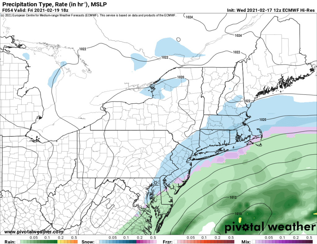
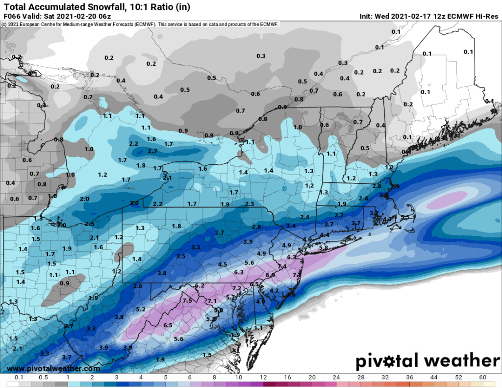
Yeah gfs and Euro similar in that regard where folks to the east (mainly LI) don't do too well from the front end of the system tomorrow but catch some snow on the back end Friday. We shall see.

billg315- Advanced Forecaster - Mod

- Posts : 4564
Reputation : 185
Join date : 2015-01-24
Age : 50
Location : Flemington, NJ
 Re: Thursday's Mothrazilla, Part II: First Forecast
There is the WAA which I suspect will travel a little north of where the Euro has it based on the jet streak and another wave that rides the baroclinic zone that sets up to our SE. Those waves that ride baroclinic can produce more than being shown currently. Just a slightly stronger low makes a big difference.
Euro low trajectory and placement keeps this as mainly snow which not having strong frontogenesis I would tend to believe more snow than not.
Euro low trajectory and placement keeps this as mainly snow which not having strong frontogenesis I would tend to believe more snow than not.
heehaw453- Advanced Forecaster

- Posts : 3942
Reputation : 86
Join date : 2014-01-20
Location : Bedminster Township, PA Elevation 600' ASL
 Re: Thursday's Mothrazilla, Part II: First Forecast
Follow the seasonal trends. Euro and GFS will come north with tonight’s runs.heehaw453 wrote:There is the WAA which I suspect will travel a little north of where the Euro has it based on the jet streak and another wave that rides the baroclinic zone that sets up to our SE. Those waves that ride baroclinic can produce more than being shown currently. Just a slightly stronger low makes a big difference.
Euro low trajectory and placement keeps this as mainly snow which not having strong frontogenesis I would tend to believe more snow than not.

nutleyblizzard- Senior Enthusiast

- Posts : 1964
Reputation : 41
Join date : 2014-01-30
Age : 58
Location : Nutley, new jersey
 Re: Thursday's Mothrazilla, Part II: First Forecast
nutleyblizzard wrote:Follow the seasonal trends. Euro and GFS will come north with tonight’s runs.heehaw453 wrote:There is the WAA which I suspect will travel a little north of where the Euro has it based on the jet streak and another wave that rides the baroclinic zone that sets up to our SE. Those waves that ride baroclinic can produce more than being shown currently. Just a slightly stronger low makes a big difference.
Euro low trajectory and placement keeps this as mainly snow which not having strong frontogenesis I would tend to believe more snow than not.
The Super Bowl storm trended south.

moleson- Posts : 34
Reputation : 0
Join date : 2013-01-07
 Re: Thursday's Mothrazilla, Part II: First Forecast
18z NAM's heaviest banding shifted slightly south (about 15-20 miles) from the last run. Also a little lighter on the totals. But still generally a 4-8" storm for most of the area. The heaviest band is now oriented from Philadelphia/ChestCo/MontCo/BucksCo in PA to Hunterdon/Mercer/Somerset/Middlesex in NJ and then onto LI.

billg315- Advanced Forecaster - Mod

- Posts : 4564
Reputation : 185
Join date : 2015-01-24
Age : 50
Location : Flemington, NJ

aiannone- Senior Enthusiast - Mod

- Posts : 4828
Reputation : 92
Join date : 2013-01-07
Location : Saint James, LI (Northwest Suffolk Co.)
 Re: Thursday's Mothrazilla, Part II: First Forecast
I'm seeing reports of 4-8" tomorrow and 1-3" on Friday. That'd be great!

Irish- Pro Enthusiast

- Posts : 788
Reputation : 19
Join date : 2019-01-16
Age : 46
Location : Old Bridge, NJ
essexcountypete likes this post
 Re: Thursday's Mothrazilla, Part II: First Forecast
Irish wrote:I'm seeing reports of 4-8" tomorrow and 1-3" on Friday. That'd be great!
You look to be in a good spot for this one.

essexcountypete- Pro Enthusiast

- Posts : 783
Reputation : 12
Join date : 2013-12-09
Location : Bloomfield, NJ
Irish likes this post
 Re: Thursday's Mothrazilla, Part II: First Forecast
CBS-AM says "possible 8-12" and then Craig Allen comes on minutes later and says 4-8" is still the forecast.

essexcountypete- Pro Enthusiast

- Posts : 783
Reputation : 12
Join date : 2013-12-09
Location : Bloomfield, NJ
 Re: Thursday's Mothrazilla, Part II: First Forecast
URGENT - WINTER WEATHER MESSAGE
National Weather Service New York NY
355 PM EST Wed Feb 17 2021
CTZ009-NJZ004-006-104>108-NYZ071>075-078-176>179-181200-
/O.UPG.KOKX.WS.A.0003.210218T1100Z-210219T2100Z/
/O.NEW.KOKX.WW.Y.0009.210218T0900Z-210220T0000Z/
Southern Fairfield-Eastern Passaic-Hudson-Eastern Bergen-
Western Essex-Eastern Essex-Western Union-Eastern Union-
Southern Westchester-New York (Manhattan)-Bronx-
Richmond (Staten Island)-Kings (Brooklyn)-Northwestern Suffolk-
Northern Queens-Northern Nassau-Southern Queens-Southern Nassau-
355 PM EST Wed Feb 17 2021
...WINTER WEATHER ADVISORY IN EFFECT FROM 4 AM THURSDAY TO 7 PM
EST FRIDAY...
* WHAT...Snow expected. Snowfall accumulations of 3 to 6 inches
are expected Thursday, with total snowfall accumulations of 5
to 9 inches by the end of the event on Friday. A light glaze of
ice accumulation is possible Thursday Night as well.
* WHERE...Portions of northeast New Jersey, southern Connecticut
and southeast New York.
_________________
-Alex Iannone-

aiannone- Senior Enthusiast - Mod

- Posts : 4828
Reputation : 92
Join date : 2013-01-07
Location : Saint James, LI (Northwest Suffolk Co.)
 Re: Thursday's Mothrazilla, Part II: First Forecast
Wwa for 5 to 9. Would normally be a wsw but due to duration it was made a wwa. Not sure I've seen that b4 due to duration. I wonder how much actually sticks arpund as it's go be light most the time. I don't foresee any road issues really.

jmanley32- Senior Enthusiast

- Posts : 20648
Reputation : 108
Join date : 2013-12-13
Age : 43
Location : Yonkers, NY
 Re: Thursday's Mothrazilla, Part II: First Forecast
WINTER STORM WARNING IN EFFECT FROM 4 AM THURSDAY TO 10 AM EST
FRIDAY...
* WHAT...Heavy mixed precipitation expected. Total snow
accumulations of 4 to 6 inches and ice accumulations of a
light glaze.
* WHERE...Portions of central, northern, northwest and southern
New Jersey, southeast Pennsylvania and northern Delaware.
* WHEN...From 4 AM Thursday to 10 AM EST Friday.
* IMPACTS...Travel could be very difficult. The hazardous
conditions could impact the Thursday morning, Thursday evening,
and Friday morning commutes.
* ADDITIONAL DETAILS...Snow overspreads the area early Thursday
morning and could be heavy at times in the morning and early
afternoon. A change to sleet and freezing rain is expected by
late afternoon or evening. Light wintry precipitation will
likely continue into the daytime hours on Friday.

Irish- Pro Enthusiast

- Posts : 788
Reputation : 19
Join date : 2019-01-16
Age : 46
Location : Old Bridge, NJ
 Re: Thursday's Mothrazilla, Part II: First Forecast
Seems like a long duration for not much accumulation 

GreyBeard- Senior Enthusiast

- Posts : 732
Reputation : 34
Join date : 2014-02-12
Location : Boca Raton, Fl.
essexcountypete and Vinnydula like this post
 Re: Thursday's Mothrazilla, Part II: First Forecast
Winter Storm Warning for me in Sussex, 5-8 inches of heavy snow.
Honestly, that's right in the sweet spot for me. I got my 2+ ft. event this winter. Give me 6 inches of nice snow and I will ALWAYS be satisfied.
Honestly, that's right in the sweet spot for me. I got my 2+ ft. event this winter. Give me 6 inches of nice snow and I will ALWAYS be satisfied.

DAYBLAZER- Posts : 228
Reputation : 20
Join date : 2017-03-12
Location : Hopatcong, NJ Sussex County
heehaw453 and Irish like this post
 Re: Thursday's Mothrazilla, Part II: First Forecast
I have a WWA as well with up to 9 possible. Funny if we max out with only a WAA

Grselig- Senior Enthusiast

- Posts : 1410
Reputation : 140
Join date : 2013-03-04
Age : 54
Location : Wayne NJ

aiannone- Senior Enthusiast - Mod

- Posts : 4828
Reputation : 92
Join date : 2013-01-07
Location : Saint James, LI (Northwest Suffolk Co.)
Artingerb- Posts : 11
Reputation : 0
Join date : 2019-03-03
Location : Lake Ariel, PA 18436
 Re: Thursday's Mothrazilla, Part II: First Forecast
Okay the Warning in NJ makes no sense and a WWA in Upton for the same amount of snow and duration. I do not care but my question is do they have different criteria for a warning versus WWA? Upton talked about the duration being why they made it a WWA versus warning but the total for me is 5-9 which is higher than some of the warnings in NJ.

jmanley32- Senior Enthusiast

- Posts : 20648
Reputation : 108
Join date : 2013-12-13
Age : 43
Location : Yonkers, NY

jmanley32- Senior Enthusiast

- Posts : 20648
Reputation : 108
Join date : 2013-12-13
Age : 43
Location : Yonkers, NY
 Re: Thursday's Mothrazilla, Part II: First Forecast
The "long duration" aspect of this not being a WSW for some seems a bit misguided from the NWS to me in that, for many people the bulk of that accumulation WILL be in a 12 hour span -- primarily from about 6 a.m. tomorrow morning to 6 p.m. in the evening. Most of what falls after that will either be light/and or mixed with sleet/frz rain. So if you're in a 5-9 or 6-8 zone, I'm thinking you're getting most of that during the day tomorrow. The exception might be Long Island where you might add about half of your total on Friday so it really will be a 24-plus hour event.
Where I am, I'd bet that 95% or more of my 4-6 (or isolated 8") will fall between sunrise and sunset tomorrow. Of course Mt Holly has me in a WSW so that is different from Upton.
Where I am, I'd bet that 95% or more of my 4-6 (or isolated 8") will fall between sunrise and sunset tomorrow. Of course Mt Holly has me in a WSW so that is different from Upton.

billg315- Advanced Forecaster - Mod

- Posts : 4564
Reputation : 185
Join date : 2015-01-24
Age : 50
Location : Flemington, NJ
 Re: Thursday's Mothrazilla, Part II: First Forecast
Jman I don't think that will happen. Surface temps are expected to be at or below freezing for most of this event and the snow should start accumulating early before the sun angle comes into play so it should accumulate from the get-go and build on that. Also check out my post from a couple minutes ago. I don't think those totals are truly spread over 24-36 hours. I think most falls in about 12 hours and then just light and mixed stuff from tomorrow evening through Friday afternoon (again, except Long Island which could see a back-end thump).

billg315- Advanced Forecaster - Mod

- Posts : 4564
Reputation : 185
Join date : 2015-01-24
Age : 50
Location : Flemington, NJ
 Re: Thursday's Mothrazilla, Part II: First Forecast
LOL. The difference between GFS and GFSv16 is pretty dramatic as to where it places heavier snowfall amounts. This is 24-36 hours out. The models are really not having much consensus even at this range.
e.g., GFSv16 puts DC around 9" of snow within 30 hours and GFS puts DC at 2" in that same 30 hours.
e.g., GFSv16 puts DC around 9" of snow within 30 hours and GFS puts DC at 2" in that same 30 hours.
heehaw453- Advanced Forecaster

- Posts : 3942
Reputation : 86
Join date : 2014-01-20
Location : Bedminster Township, PA Elevation 600' ASL
 Re: Thursday's Mothrazilla, Part II: First Forecast
Actually, if that "trailer" system or the sort of second, secondary low does get going Friday early enough to dump snow on NJ/NY I think the storm totals may be underdone because you could possibly add another 1-3 on Friday but even if that's factored into the 6-9 (which it may be since tomorrow seems more like a 4-6) keep in mind that's not evenly spread over 36 hours. It's more like a 12 hour 6" storm tomorrow and then a 6 hour 3" storm on Friday. Almost two storms not one.
Last edited by billg315 on Wed Feb 17, 2021 7:02 pm; edited 1 time in total

billg315- Advanced Forecaster - Mod

- Posts : 4564
Reputation : 185
Join date : 2015-01-24
Age : 50
Location : Flemington, NJ
 Re: Thursday's Mothrazilla, Part II: First Forecast
heehaw453 wrote:LOL. The difference between GFS and GFSv16 is pretty dramatic as to where it places heavier snowfall amounts. This is 24-36 hours out. The models are really not having much consensus even at this range.
e.g., GFSv16 puts DC around 9" of snow within 30 hours and GFS puts DC at 2" in that same 30 hours.
18z GFS vs 18z GFS v16 LOL


_________________
-Alex Iannone-

aiannone- Senior Enthusiast - Mod

- Posts : 4828
Reputation : 92
Join date : 2013-01-07
Location : Saint James, LI (Northwest Suffolk Co.)
Page 3 of 18 •  1, 2, 3, 4 ... 10 ... 18
Page 3 of 18
Permissions in this forum:
You cannot reply to topics in this forum
 Home
Home


