Long Range Discussion 22.0
+33
skinsfan1177
chief7
WeatherBob
emokid51783
hyde345
jmanley32
dsix85
jaydoy
billg315
lglickman1
CPcantmeasuresnow
Snow88
mmanisca
phil155
weatherwatchermom
Dunnzoo
nutleyblizzard
Radz
Irish
Wheezer
Math23x7
rb924119
SENJsnowman
heehaw453
algae888
aiannone
MattyICE
frank 638
Frank_Wx
docstox12
dkodgis
amugs
sroc4
37 posters
Page 8 of 31
Page 8 of 31 •  1 ... 5 ... 7, 8, 9 ... 19 ... 31
 Re: Long Range Discussion 22.0
algae888 wrote:Rb If I understand correctly from your post the last several days you're Punting the 1st 6 weeks of
met Winter and you're excited about that. Winter starting mid January just doesn't do it for me. for the most part it would be a Winter fail
Yeah, I think we are out of the game until mid-January, but by Week 3 of January we start making up for lost time. To clarify, I’m NOT happy that we are losing the opening month (plus) of my favorite season, but unlike some other years, I don’t see any reason to jump off the cliff. Right now I fully believe that we are just going to have to be patient, and in time, we will be rewarded pretty handsomely. As I said, once we flip, which I think will be during Week 2 of January, I think we flip hard and have an old-fashioned winter from Week 3 of January through most, if not even all of March. In looking at how I expect this winter to play out regarding the overall evolution of winter, I like ‘17-‘18 as an analog, but we will be about a month to six weeks ahead of that pace. Granted, I’ve not compared ENSO or QBO states, SST configurations, or things like that, and that may be my downfall. But conceptually, I like a similar evolution to how that winter played out, just on an earlier timeline relative to the seasonality.
rb924119- Meteorologist

- Posts : 7040
Join date : 2013-02-06
sroc4 and heehaw453 like this post
 Re: Long Range Discussion 22.0
rb924119 wrote:algae888 wrote:Rb If I understand correctly from your post the last several days you're Punting the 1st 6 weeks of
met Winter and you're excited about that. Winter starting mid January just doesn't do it for me. for the most part it would be a Winter fail
Yeah, I think we are out of the game until mid-January, but by Week 3 of January we start making up for lost time. To clarify, I’m NOT happy that we are losing the opening month (plus) of my favorite season, but unlike some other years, I don’t see any reason to jump off the cliff. Right now I fully believe that we are just going to have to be patient, and in time, we will be rewarded pretty handsomely. As I said, once we flip, which I think will be during Week 2 of January, I think we flip hard and have an old-fashioned winter from Week 3 of January through most, if not even all of March. In looking at how I expect this winter to play out regarding the overall evolution of winter, I like ‘17-‘18 as an analog, but we will be about a month to six weeks ahead of that pace. Granted, I’ve not compared ENSO or QBO states, SST configurations, or things like that, and that may be my downfall. But conceptually, I like a similar evolution to how that winter played out, just on an earlier timeline relative to the seasonality.
I'm impressed that you have the conviction to make that kind of call. It's very easy to bail on winter if the first half is poor. Mob mentality can many times take over and make one change their mind with or w/out good reason. Kudos and am certainly rooting for this!
heehaw453- Advanced Forecaster

- Posts : 3914
Join date : 2014-01-20
rb924119 likes this post
 Re: Long Range Discussion 22.0
heehaw453 wrote:rb924119 wrote:algae888 wrote:Rb If I understand correctly from your post the last several days you're Punting the 1st 6 weeks of
met Winter and you're excited about that. Winter starting mid January just doesn't do it for me. for the most part it would be a Winter fail
Yeah, I think we are out of the game until mid-January, but by Week 3 of January we start making up for lost time. To clarify, I’m NOT happy that we are losing the opening month (plus) of my favorite season, but unlike some other years, I don’t see any reason to jump off the cliff. Right now I fully believe that we are just going to have to be patient, and in time, we will be rewarded pretty handsomely. As I said, once we flip, which I think will be during Week 2 of January, I think we flip hard and have an old-fashioned winter from Week 3 of January through most, if not even all of March. In looking at how I expect this winter to play out regarding the overall evolution of winter, I like ‘17-‘18 as an analog, but we will be about a month to six weeks ahead of that pace. Granted, I’ve not compared ENSO or QBO states, SST configurations, or things like that, and that may be my downfall. But conceptually, I like a similar evolution to how that winter played out, just on an earlier timeline relative to the seasonality.
I'm impressed that you have the conviction to make that kind of call. It's very easy to bail on winter if the first half is poor. Mob mentality can many times take over and make one change their mind with or w/out good reason. Kudos and am certainly rooting for this!
Thanks, heehaw! It may all be for naught, in all honesty. But I’ve come to a couple conclusions through my relatively short career of forecasting (roughly 13 years with any sound meteorological reasoning), that 1. If you are able to develop a strong belief in a particular forecast, and it’s based on sound reasoning, experience, etc., and certain “checkpoints” of your forecast are shown to have merit (in this case, for example, my first checkpoint was to see if the MJO actually gains amplitude and slows in Phases 6/7, which, so far, appears to be garnering support from guidance now), then why abandon what’s gotten you to that point, regardless of what others say? Stay the course. Make your stand and stick with it. I’d rather be wrong with my initial idea(s) once or twice and have to adjust, instead of following the model cycles and switch everything up every six hours. What skill is there in that? 2. The way I look at it is it’s always a net positive: Either my forecast busts and we have a snowless winter (neither of which are in my control) BUT I own up to the loss and gain an opportunity to learn something to improve my skills down the road, OR, my forecast verifies and we salvage what would have been a miserable winter. Sure, I’ll take flack from people either way during and after the process, but so what? It’s how you learn, and part of the process. Trial and error. Nobody knows tomorrow, but it’s the thrill of trying and learning that I love.
Sometimes I hold on too long, as others can attest. And that’s just me being too stubborn, every time haha but acknowledging the above mindset, and being able to accept criticism and carry out some self inflection/analysis on events that I got wrong, I think, has helped me to become a better forecaster; a more objective forecaster. If I have reason to change or adjust, I will. But right now, as I said, I have a real good feeling that this will be a tale of two winters.
rb924119- Meteorologist

- Posts : 7040
Reputation : 195
Join date : 2013-02-06
Age : 32
Location : Greentown, Pa
Frank_Wx, sroc4, amugs, kalleg and heehaw453 like this post
 Re: Long Range Discussion 22.0
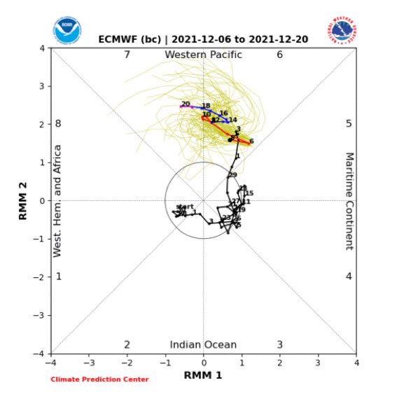
rb924119 wrote:The match has been lit. How long and how strong can we go? I still like the amplitude of the GEFS, and a blend of the GEFS and EC for phase evolution:
Let’s watch it burn and see what happens. I like our prospects, increasingly from day to day, I might add. And, the long-range GEFS are beginning to show signs of EXACTLY what I’m looking for in the Strat. And with the magnitude that they are showing it at a two-week lead, it’s impressive. I know it’s the GFS at extended range, but when it fits my preconceived ideas, I start paying attention. I’m trying to claw around for additional details, but it’s tough lol so sit tight folks, and TRUST THE PROCESS.
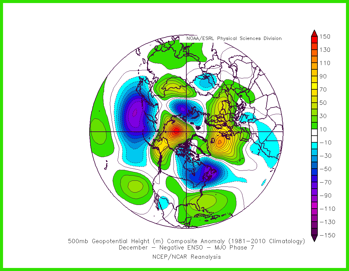
Additionally, some of you are going to see “MJO Phase 7 at amplitude in December is cold”. Yes, at face value. But the problem is it’s enhancing the La Niña signal in the background state; it’s not acting on a tropically “neutral” playing field. This means that it will act very differently than it otherwise would. I believe a strong La Niña response (which is about what you’ll have if you combine the background La Niña forcing with the MJO pulse) is an all-out torch for us, similar to strong El Niño, with an enhanced Southeast ridge, and that should be our result here during the next several weeks. But somebody please check my memory on this and correct me if I’m wrong.
Regarding your last point about a phase 7 MJO during La Niña, you may be onto something regarding the SE ridge, but I’m pushing back a bit on the “torch” comment. The H5 historical map features an anomalous ridge directly over the Pole. A moderate to strong -AO would force arctic air into our CONUS, but it will be tested by the SE ridge. Unfortunately, the Atlantic pattern doesnt look great so your storm tracks may average N&W still, but there will definitely be some cold air to work with. More importantly is the impact this Trop pattern will have on the Stat. If this comes to fruition, I would expect a drastic weakening and/or SSW.
Time will tell…
_________________
_______________________________________________________________________________________________________
CLICK HERE to view NJ Strong Snowstorm Classifications
rb924119 likes this post
 Re: Long Range Discussion 22.0
CFS December forecast
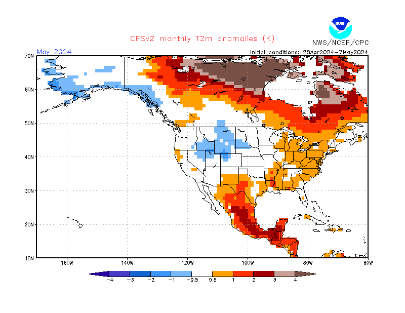
GEFS December forecast days 8-12 and 12-16


The cold air is on the other side of the continent (-WPO, +AO, +NAO)
Gotta get the WPO to -EPO and the MJO in phase 7 MAY do that

GEFS December forecast days 8-12 and 12-16


The cold air is on the other side of the continent (-WPO, +AO, +NAO)
Gotta get the WPO to -EPO and the MJO in phase 7 MAY do that
_________________
_______________________________________________________________________________________________________
CLICK HERE to view NJ Strong Snowstorm Classifications
rb924119 likes this post
 Re: Long Range Discussion 22.0
Frank, I have a response pending, but I want to look at some maps first. However, I can’t figure out how to make a 500mb composite map of multiple variables like you did (negative ENSO, MJO phase, etc.)…..would you mind helping me figure it out? Lmao
rb924119- Meteorologist

- Posts : 7040
Reputation : 195
Join date : 2013-02-06
Age : 32
Location : Greentown, Pa
 Re: Long Range Discussion 22.0
rb924119 wrote:Frank, I have a response pending, but I want to look at some maps first. However, I can’t figure out how to make a 500mb composite map of multiple variables like you did (negative ENSO, MJO phase, etc.)…..would you mind helping me figure it out? Lmao
Just gotta translate it to English
https://www.meteonetwork.it/models/mjo/
But I sometimes make my own using this
https://psl.noaa.gov/cgi-bin/data/getpage.pl
_________________
_______________________________________________________________________________________________________
CLICK HERE to view NJ Strong Snowstorm Classifications
 Re: Long Range Discussion 22.0
Frank_Wx wrote:rb924119 wrote:Frank, I have a response pending, but I want to look at some maps first. However, I can’t figure out how to make a 500mb composite map of multiple variables like you did (negative ENSO, MJO phase, etc.)…..would you mind helping me figure it out? Lmao
Just gotta translate it to English
https://www.meteonetwork.it/models/mjo/
But I sometimes make my own using this
https://psl.noaa.gov/cgi-bin/data/getpage.pl
Ray go to this site here: https://psl.noaa.gov/data/composites/day/
Im in the process of looking at some stuff, as well specifically this map that has been posted a few times regarding what the MJO in phase 6 is supposed to look like in Decem\ber:
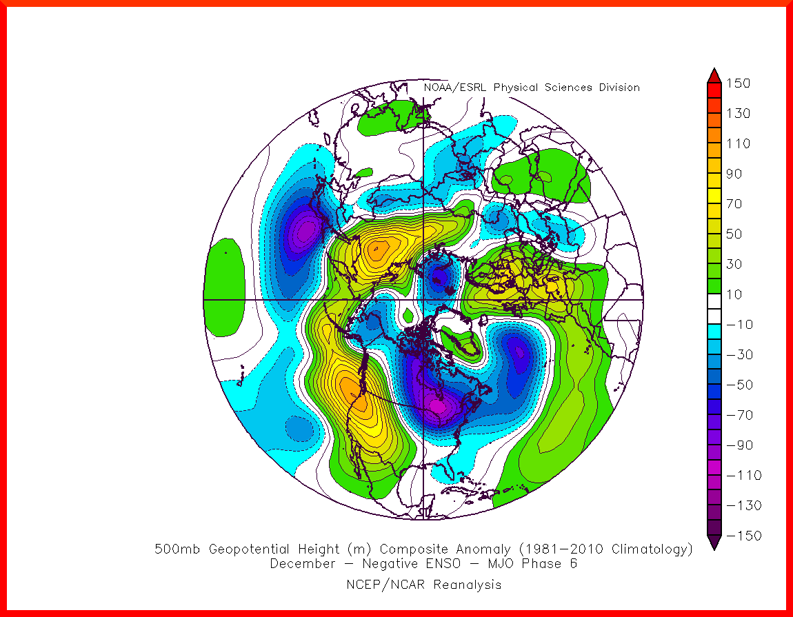
Its a bit deceiving. At first glance it looks cold and has potential for snow if taken at face value. Trough in the east, Ridge along the west coast. But if you haven't already go to the site that frank posted. This is where this map and the one that he posted regarding phase 7 came from: https://www.meteonetwork.it/models/mjo/
He's right in that you need to translate it. I open in chrome. Top right of the address bar next to the star that I can use to save the link to favorites is the translate icon thing. I think the rest is fairly self explanatory . Once translated you will see the key at the top of the site shows that Red is low confidence, Blue Low-mod, and green high confidence in the map for any given MJO phase vs ENSO status and Month. You will notice that for December the box for Nina phase 6 for Dec is Red(low confidence).
Affter further investigation using these two sites, the historical MJO phases relative to La Nina years: http://www.bom.gov.au/climate/mjo/
https://ggweather.com/enso/oni.htm
there are only 2 times that the MJO came out in phase 6 in December during a La Nina ENSO. Dec 2000, and Dec 2017. Now the MJO site only goes back as far as 1975 so I cant find that data on what the MJO was doing in La Nina years prior to 1975:


Obviously with only 2 prior years the confidence in the mean maps will be low. Using the first link I posted, the Map Generator I plugged in the the dates the MJO was in Dec starting with a few days prior to getting into 6 and ending with as few days after and these are the results for those two years.


When compared with the above map you can see that the blend of both of these two maps looks pretty close to this map. BUT when you read between the lines its really isnt that cold or that conducive to snow chances when looking at the individual maps.

In order to make the two maps above only the areas where I have arrows need manipulation. The area that I have circled m pretty sure you can actually plug in multiple dates and years to get the blend of all of the entered dates. IE: I only generated the map for Dec 2000 between Dec 4th-20th and 2017 Dec 4th-23rd and generated two separate maps. However, Im pretty sure using the area I have circled on that site you can enter both of those data sets and generate one mean map that is the blend of both 2000 and 2017 between the specific dates specified. (I hope that makes senses) I havent figured that part out yet.


Now if we look at the Mean map for MJO phase 7 again that our area is right on the interface between the trough and SE ridge. And so yes it can be cold, reading between the lines, phase 7 is not as cold and conducive as one would think as the SE ridge is literally at the front door, and so stronger systems in the plains likely pump the ridge, heights expand along the EC, warm sector, system passes N&W, cold front pushes through, its gets chilly, and then things moderate before the next system. Rinse wash repeat. Reading between the lines of the two Phase 6 maps seem to go along nicely with that same narrative as well, with slightly different ways of getting there.

A few other things Ill be looking at after the fact will be what the strat looks like in those two Decembers, 2000, 2017 compared to this years December relative to the time the MJO ends up spending in phase 6, and or 7.
_________________
"In weather and in life, there's no winning and losing; there's only winning and learning."
WINTER 2012/2013 TOTALS 43.65"WINTER 2017/2018 TOTALS 62.85" WINTER 2022/2023 TOTALS 4.9"
WINTER 2013/2014 TOTALS 64.85"WINTER 2018/2019 TOTALS 14.25" WINTER 2023/2024 TOTALS 13.1"
WINTER 2014/2015 TOTALS 71.20"WINTER 2019/2020 TOTALS 6.35"
WINTER 2015/2016 TOTALS 35.00"WINTER 2020/2021 TOTALS 37.75"
WINTER 2016/2017 TOTALS 42.25"WINTER 2021/2022 TOTALS 31.65"

sroc4- Admin

- Posts : 8446
Reputation : 302
Join date : 2013-01-07
Location : Wading River, LI
rb924119 and heehaw453 like this post
 Re: Long Range Discussion 22.0
Great discussion here gents. Okay I am looking at some OLR modelling and i know this can all change BUT this gives some hope for teh later part of Dec if the MJO wave gets into these phases:
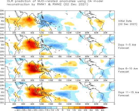
Forecast - pretty good wave SD 2-2.5 -would love to see a 3 into phase 7
GEFS

Euro too

OhioWx posted this and this an extended range MJO forecast that would bode well as pointed out for Late Dec and early Jan

Shows MJO getting to 7 then the golden 8 with a decent wave. If this can occur this can save the later part of Dec into early Jan BUT the wave needs to get there 1st.
Also the amplitude of teh MJO phase we need to be moderate in phase 6 and 7 2SD -3SD strong to help produce the heat flux needed to knock around the SPV.
We also have the Urals/Scandinavian HP to help knock it on the back side.
From 33 n Rain - great depiction of what we have and need more of

Starting to nose into the regions noted above - we need more of that heat to do so to start the process hopefully moving up in time which it is hinting at.

Ugly look for sure BUT as Rb and SROC have pointed out AN train will pull into the station (however you want to look at the train) and we get to some real goods as we move into Later Dec/early Jan if this keeps up IMO. Entrenchment will most likely be a bit later than sooner but we may get to see some good cold shots with brief moderation again if this comes together. After that I say buckle up for a good stretch of the heart of winter and latter part.

Forecast - pretty good wave SD 2-2.5 -would love to see a 3 into phase 7
GEFS

Euro too

OhioWx posted this and this an extended range MJO forecast that would bode well as pointed out for Late Dec and early Jan

Shows MJO getting to 7 then the golden 8 with a decent wave. If this can occur this can save the later part of Dec into early Jan BUT the wave needs to get there 1st.
Also the amplitude of teh MJO phase we need to be moderate in phase 6 and 7 2SD -3SD strong to help produce the heat flux needed to knock around the SPV.
We also have the Urals/Scandinavian HP to help knock it on the back side.
From 33 n Rain - great depiction of what we have and need more of

Starting to nose into the regions noted above - we need more of that heat to do so to start the process hopefully moving up in time which it is hinting at.

Ugly look for sure BUT as Rb and SROC have pointed out AN train will pull into the station (however you want to look at the train) and we get to some real goods as we move into Later Dec/early Jan if this keeps up IMO. Entrenchment will most likely be a bit later than sooner but we may get to see some good cold shots with brief moderation again if this comes together. After that I say buckle up for a good stretch of the heart of winter and latter part.
_________________
Mugs
AKA:King: Snow Weenie
Self Proclaimed
WINTER 2014-15 : 55.12" +.02 for 6 coatings (avg. 35")
WINTER 2015-16 Total - 29.8" (Avg 35")
WINTER 2016-17 : 39.5" so far

amugs- Advanced Forecaster - Mod

- Posts : 15130
Reputation : 213
Join date : 2013-01-07
Age : 54
Location : Hillsdale,NJ
 Re: Long Range Discussion 22.0
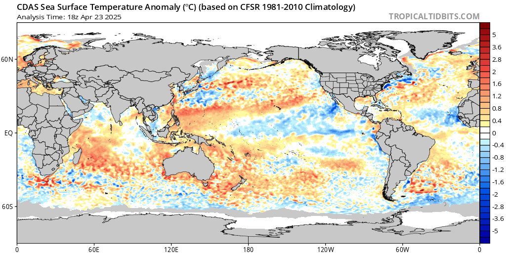
A very prominent La Niña…last couple of weeks of data suggest it may only get stronger.

_________________
_______________________________________________________________________________________________________
CLICK HERE to view NJ Strong Snowstorm Classifications
 Re: Long Range Discussion 22.0
frank is this good or bad for usFrank_Wx wrote:A very prominent La Niña…last couple of weeks of data suggest it may only get stronger.
frank 638- Senior Enthusiast

- Posts : 2874
Reputation : 37
Join date : 2016-01-01
Age : 41
Location : bronx ny
 Re: Long Range Discussion 22.0
Looks like Dec 8 is looking better and better for the “S” word

dkodgis- Senior Enthusiast

- Posts : 2671
Reputation : 98
Join date : 2013-12-29
 Re: Long Range Discussion 22.0
Before I respond to the above comments (probably tomorrow), I just want to say one thing, and I’ll leave you all hanging for now……
UH OHHHHH

UH OHHHHH
rb924119- Meteorologist

- Posts : 7040
Reputation : 195
Join date : 2013-02-06
Age : 32
Location : Greentown, Pa
 Re: Long Range Discussion 22.0
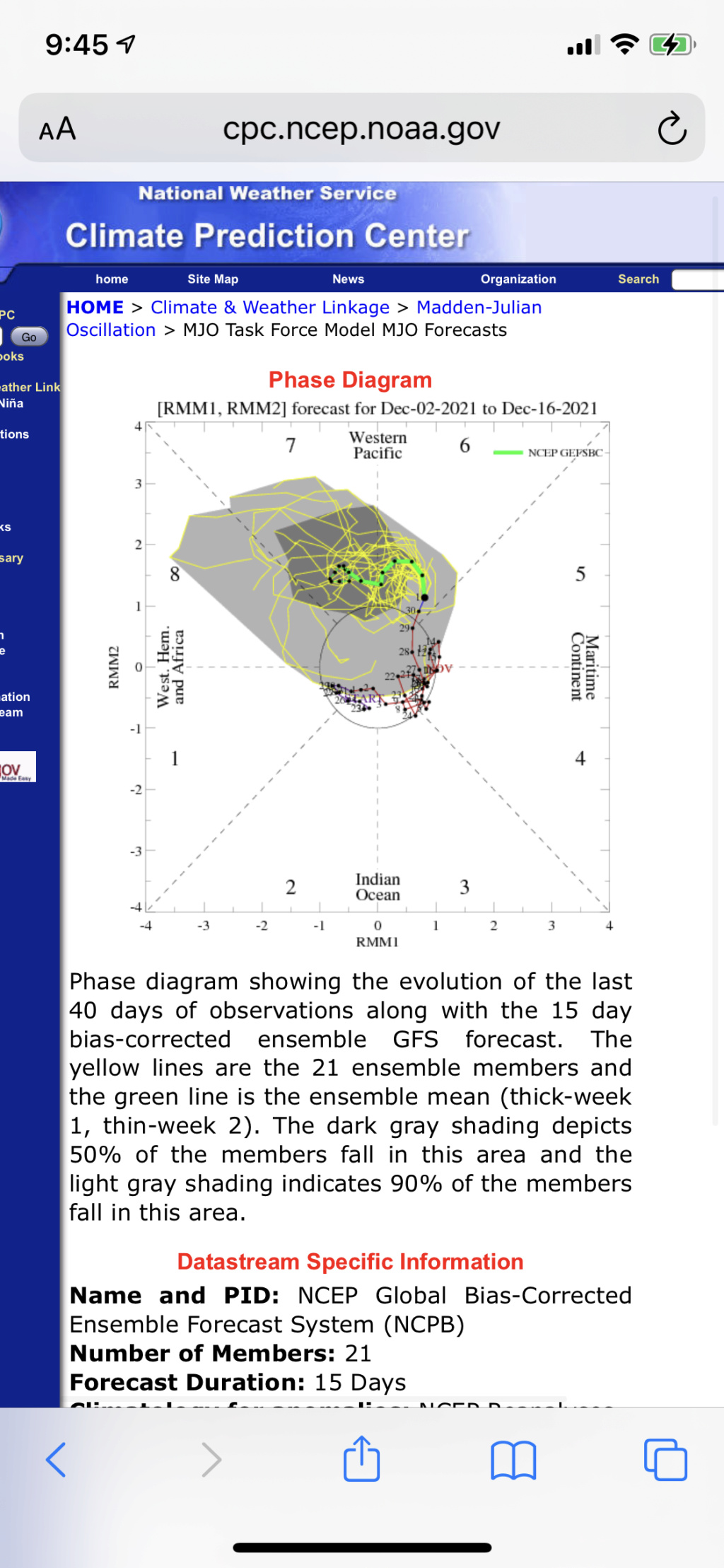
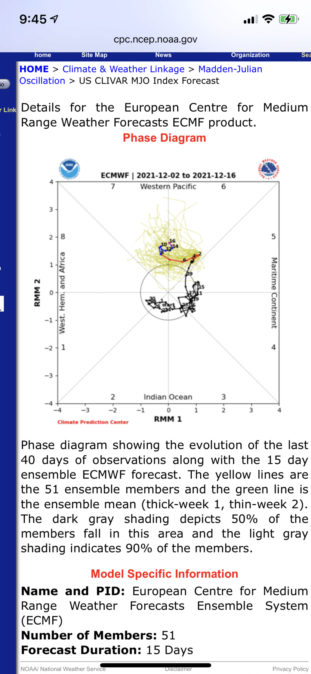
Almost all of the ECM ensemble members forecast the MJO to enter phase 7 by the end of this month. What remains unclear is the amplitude of this tropical wave upon arrival in this region.
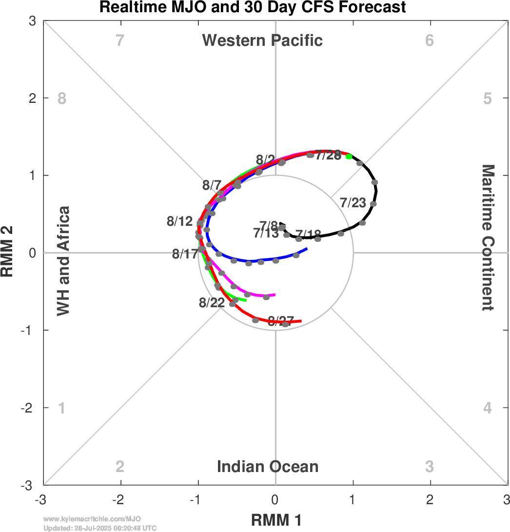

_________________
_______________________________________________________________________________________________________
CLICK HERE to view NJ Strong Snowstorm Classifications
 Re: Long Range Discussion 22.0
[quote="Frank_Wx"]Almost all of the ECM ensemble members forecast the MJO to enter phase 7 by the end of this month. What remains unclear is the amplitude of this tropical wave upon arrival in this region.

[/quoteThe current location of MJO and the dates on the graph posted don't line up. Is the current location not already in phase 6?]

[/quoteThe current location of MJO and the dates on the graph posted don't line up. Is the current location not already in phase 6?]
Wheezer- Posts : 30
Reputation : 6
Join date : 2017-11-08
Location : Cincinnati, Oh
 Re: Long Range Discussion 22.0
This is the one I meant to post
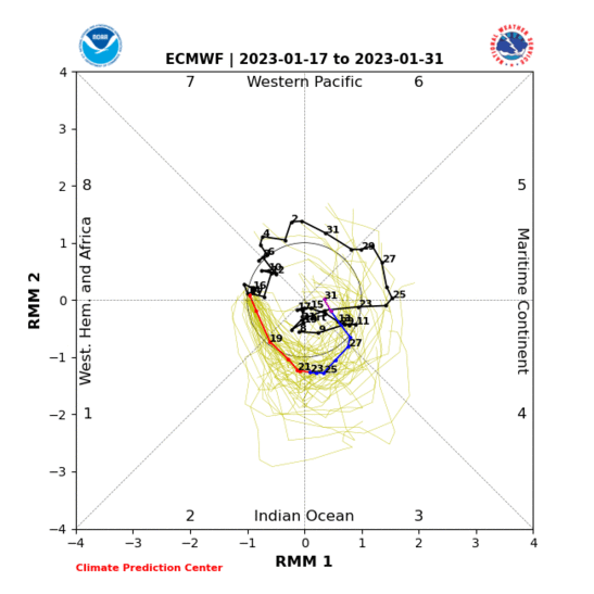
The one from earlier shows actuals (in gray) and a 30 day forecast in colors by model

The one from earlier shows actuals (in gray) and a 30 day forecast in colors by model
_________________
_______________________________________________________________________________________________________
CLICK HERE to view NJ Strong Snowstorm Classifications
 Re: Long Range Discussion 22.0
All of this…yet…can’t forget the next 20 to 30 days will feature pretty warm weather. We have the storm system for mid next week, which is starting to look pretty white for far N&W areas. The coast will have to wait their turn 
_________________
_______________________________________________________________________________________________________
CLICK HERE to view NJ Strong Snowstorm Classifications
 Re: Long Range Discussion 22.0
not sure what effect we will have from the MJO going into a phase 7 since the wave is South of the equator. From what I've been reading it seems to affect the Southern hemisphere more than us. still uncertain how far it gets into 7 and it reverts back to 6Frank_Wx wrote:This is the one I meant to post
The one from earlier shows actuals (in gray) and a 30 day forecast in colors by model

algae888- Advanced Forecaster

- Posts : 5311
Reputation : 46
Join date : 2013-02-05
Age : 62
Location : mt. vernon, new york
 Re: Long Range Discussion 22.0
Looks like a decent shot at snow Tuesday into Wednesday.

Irish- Pro Enthusiast

- Posts : 788
Reputation : 19
Join date : 2019-01-16
Age : 46
Location : Old Bridge, NJ
 Re: Long Range Discussion 22.0
Irish wrote:Looks like a decent shot at snow Tuesday into Wednesday.
We've been discussing in the December Observations thread, Irish
rb924119- Meteorologist

- Posts : 7040
Reputation : 195
Join date : 2013-02-06
Age : 32
Location : Greentown, Pa
Irish likes this post
 Re: Long Range Discussion 22.0
Frank_Wx wrote:rb924119 wrote:The match has been lit. How long and how strong can we go? I still like the amplitude of the GEFS, and a blend of the GEFS and EC for phase evolution:
Let’s watch it burn and see what happens. I like our prospects, increasingly from day to day, I might add. And, the long-range GEFS are beginning to show signs of EXACTLY what I’m looking for in the Strat. And with the magnitude that they are showing it at a two-week lead, it’s impressive. I know it’s the GFS at extended range, but when it fits my preconceived ideas, I start paying attention. I’m trying to claw around for additional details, but it’s tough lol so sit tight folks, and TRUST THE PROCESS.
Additionally, some of you are going to see “MJO Phase 7 at amplitude in December is cold”. Yes, at face value. But the problem is it’s enhancing the La Niña signal in the background state; it’s not acting on a tropically “neutral” playing field. This means that it will act very differently than it otherwise would. I believe a strong La Niña response (which is about what you’ll have if you combine the background La Niña forcing with the MJO pulse) is an all-out torch for us, similar to strong El Niño, with an enhanced Southeast ridge, and that should be our result here during the next several weeks. But somebody please check my memory on this and correct me if I’m wrong.
Regarding your last point about a phase 7 MJO during La Niña, you may be onto something regarding the SE ridge, but I’m pushing back a bit on the “torch” comment. The H5 historical map features an anomalous ridge directly over the Pole. A moderate to strong -AO would force arctic air into our CONUS, but it will be tested by the SE ridge. Unfortunately, the Atlantic pattern doesnt look great so your storm tracks may average N&W still, but there will definitely be some cold air to work with. More importantly is the impact this Trop pattern will have on the Stat. If this comes to fruition, I would expect a drastic weakening and/or SSW.
Time will tell…
Thanks for all of your links and discussion!! That MJO composite site has been saved to my Favorites for safe keeping :p
The point that I was making with my comment was that we are not likely to get this response of the MJO, likely because of how coupled the atmosphere is with the base state of La Niña:
Extended EURO Ensemble mean to demonstrate the expected/sensible outcome:
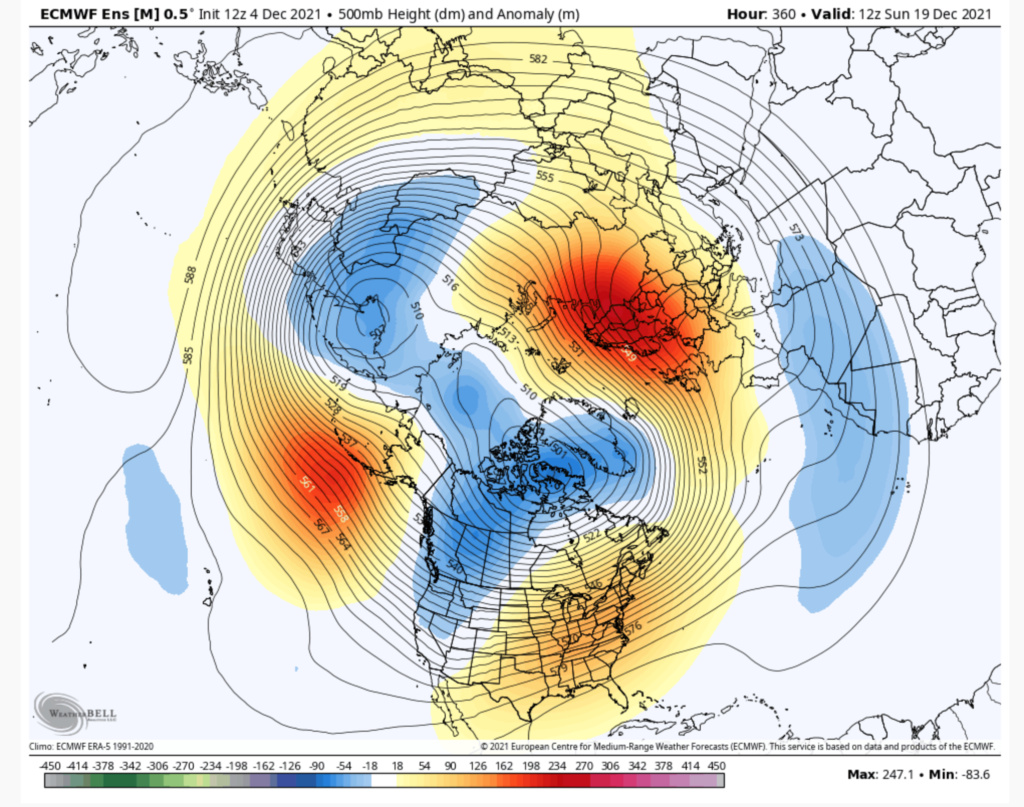
La Niña base state:
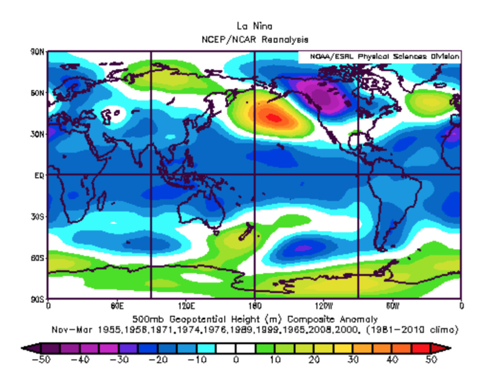
ENSO-neutral MJO Phase 7:

So, I think that the MJO is likely enhancing the well-established background La Niña atmospheric structure rather than the La Niña enhancing the MJO signal. This would explain the breakdown between the ENSO-negative MJO Phase 7 composite versus the pattern that I feel is more likely to verify - high latitude blocking is completely absent, and will be, in my opinion, thanks to the secondary coupling to the stronger than average Stratospheric PV. Additionally, the ENSO-neutral composite much more closely resembles that of the La Niña base state than the ENSO-negative composite, though the blocking in the Atlantic domain is shunted further south. In our case, this is (again) likely a result of the secondary, yet no less important, coupling to the Stratospheric PV. HOWEVER, I believe that this will change, and some of the guidance that I've been looking at is trying to hint at that, though I don't think that it's quite ready to starting pulling the trigger because it's still so far out. I will make another video regarding these longer-range thoughts, though, when I have time. Tonight's video on the December 8th potential event took the place of this discussion haha
rb924119- Meteorologist

- Posts : 7040
Reputation : 195
Join date : 2013-02-06
Age : 32
Location : Greentown, Pa
 Re: Long Range Discussion 22.0
Scott, thank you for your detailed step-by step!! It would appear that you are at the same place I am, in that you have to manually figure out what years were a particular ENSO phase, and then create your own composite of the individual years. What I'm trying to figure out is how they were able to composite multiple variables (ENSO phase AND MJO phase) together, because according to the label of the graphic, that's exactly what they did. They pulled from a predefined dataset and merged the composites. If I have time, I may have a couple leads that I could chase down to figure this out haha
Mugsy, be careful with these MJO projections. With such a strong atmospheric La Niña structure, this MJO pulse is not going to readily propagate through Phase 7. It's going to take a while. That said, I DO think that it will emerge, with amplitude, just not as soon. If you notice, the MJO is already longer and stronger in Phase 6 than it was previously forecast to be. This was to be expected, as the GEFS and CFS are generally overly ambitious in propagating this wave - it's a known bias. And considering the situation, I would caution against taking them verbatim and is why I mentioned that I like a blend of the GEFS and Euro phase propagation, BUT I DO like the GEFS amplitude forecast overall, and so far, that idea is proving to have merit. More on this in coming days, though, because I will discuss where I think this whole thing is headed down the road
Mugsy, be careful with these MJO projections. With such a strong atmospheric La Niña structure, this MJO pulse is not going to readily propagate through Phase 7. It's going to take a while. That said, I DO think that it will emerge, with amplitude, just not as soon. If you notice, the MJO is already longer and stronger in Phase 6 than it was previously forecast to be. This was to be expected, as the GEFS and CFS are generally overly ambitious in propagating this wave - it's a known bias. And considering the situation, I would caution against taking them verbatim and is why I mentioned that I like a blend of the GEFS and Euro phase propagation, BUT I DO like the GEFS amplitude forecast overall, and so far, that idea is proving to have merit. More on this in coming days, though, because I will discuss where I think this whole thing is headed down the road
rb924119- Meteorologist

- Posts : 7040
Reputation : 195
Join date : 2013-02-06
Age : 32
Location : Greentown, Pa
sroc4 likes this post
 Re: Long Range Discussion 22.0
Great work and discussions by Frank Doc, Mugs,rb, Al and heehaw! Wonderful time for the board, snow possibility for us all.What a nice boost to the Christmas spirit that will be.I am sitting over 700 feet up in the LHV of NY so I think I may see some snow on the ground.Hope it happens for all.Thanks for the great reads long range crew. Maybe if I had another life I could begin to understand it all, but my blown circuit brain at age 71 is picking it up gradually,LOL.

docstox12- Wx Statistician Guru

- Posts : 8597
Reputation : 222
Join date : 2013-01-07
Age : 73
Location : Monroe NY
sroc4, rb924119, dkodgis and SENJsnowman like this post
 Re: Long Range Discussion 22.0
rb924119 wrote:Irish wrote:Looks like a decent shot at snow Tuesday into Wednesday.
We've been discussing in the December Observations thread, Irish
Thx, I'm never sure what observation threads are for. I thought they were for daily observations already made. Long range was for weather yet to happen days/weeks out.

Irish- Pro Enthusiast

- Posts : 788
Reputation : 19
Join date : 2019-01-16
Age : 46
Location : Old Bridge, NJ
 Re: Long Range Discussion 22.0
Irish wrote:rb924119 wrote:Irish wrote:Looks like a decent shot at snow Tuesday into Wednesday.
We've been discussing in the December Observations thread, Irish
Thx, I'm never sure what observation threads are for. I thought they were for daily observations already made. Long range was for weather yet to happen days/weeks out.
Irish. No worries bother. As a general rule the long range is used to discuss the potential threats out there. Then as the one most imminent begins to seem more realistic often, but not always we then discuss just that threat in discussion, but ultimately we end up making a threat its own thread eventually when it seems like its becoming even more likely like I did today.
Again all just general rules.
_________________
"In weather and in life, there's no winning and losing; there's only winning and learning."
WINTER 2012/2013 TOTALS 43.65"WINTER 2017/2018 TOTALS 62.85" WINTER 2022/2023 TOTALS 4.9"
WINTER 2013/2014 TOTALS 64.85"WINTER 2018/2019 TOTALS 14.25" WINTER 2023/2024 TOTALS 13.1"
WINTER 2014/2015 TOTALS 71.20"WINTER 2019/2020 TOTALS 6.35"
WINTER 2015/2016 TOTALS 35.00"WINTER 2020/2021 TOTALS 37.75"
WINTER 2016/2017 TOTALS 42.25"WINTER 2021/2022 TOTALS 31.65"

sroc4- Admin

- Posts : 8446
Reputation : 302
Join date : 2013-01-07
Location : Wading River, LI
Irish likes this post
 Re: Long Range Discussion 22.0
_________________
Mugs
AKA:King: Snow Weenie
Self Proclaimed
WINTER 2014-15 : 55.12" +.02 for 6 coatings (avg. 35")
WINTER 2015-16 Total - 29.8" (Avg 35")
WINTER 2016-17 : 39.5" so far

amugs- Advanced Forecaster - Mod

- Posts : 15130
Reputation : 213
Join date : 2013-01-07
Age : 54
Location : Hillsdale,NJ
 Re: Long Range Discussion 22.0
_________________
_______________________________________________________________________________________________________
CLICK HERE to view NJ Strong Snowstorm Classifications
Page 8 of 31 •  1 ... 5 ... 7, 8, 9 ... 19 ... 31
Page 8 of 31
Permissions in this forum:
You cannot reply to topics in this forum
 Home
Home
