Long Range Discussion 22.0
Page 20 of 31 •  1 ... 11 ... 19, 20, 21 ... 25 ... 31
 Re: Long Range Discussion 22.0
jaydoy wrote:I don’t post here a lot, but these last few weeks I have placed my trust in rb, probably longer, let’s see some of that cold and white gold
Thanks, Jay!! Trying my best to deliver the goods! Haha
rb924119- Meteorologist

- Posts : 7042
Join date : 2013-02-06
rb924119- Meteorologist

- Posts : 7042
Join date : 2013-02-06
heehaw453 and MattyICE like this post
 Re: Long Range Discussion 22.0
dsix85- Pro Enthusiast

- Posts : 349
Reputation : 8
Join date : 2014-01-01
Location : New York
 Re: Long Range Discussion 22.0
dsix85 wrote:RB- are we looking at a period of sustained cold or just transient shots of cold/stormy weather during the aforementioned time frame?
My idea has been that once we transition during Week 2 of January, I think that we pretty much run the table with a colder/snowier regime overall (limited warmups) through most of March before it breaks down. So far, I see no reason to stray from the ideas that brought me to that opinion, as things are proceeding according to plan.
rb924119- Meteorologist

- Posts : 7042
Reputation : 195
Join date : 2013-02-06
Age : 32
Location : Greentown, Pa
heehaw453 likes this post
 Re: Long Range Discussion 22.0
"Build it ...and Cold n Snow ...wil come"
Or CP and Snow will come !!!!
All great information.
And I am harping on my call from mid month if not earlier that we see a NESIS thatb2nd orb3rdbweek of Jan to kick the winters arse!!
_________________
Mugs
AKA:King: Snow Weenie
Self Proclaimed
WINTER 2014-15 : 55.12" +.02 for 6 coatings (avg. 35")
WINTER 2015-16 Total - 29.8" (Avg 35")
WINTER 2016-17 : 39.5" so far

amugs- Advanced Forecaster - Mod

- Posts : 15133
Reputation : 213
Join date : 2013-01-07
Age : 54
Location : Hillsdale,NJ
rb924119 likes this post
 Re: Long Range Discussion 22.0
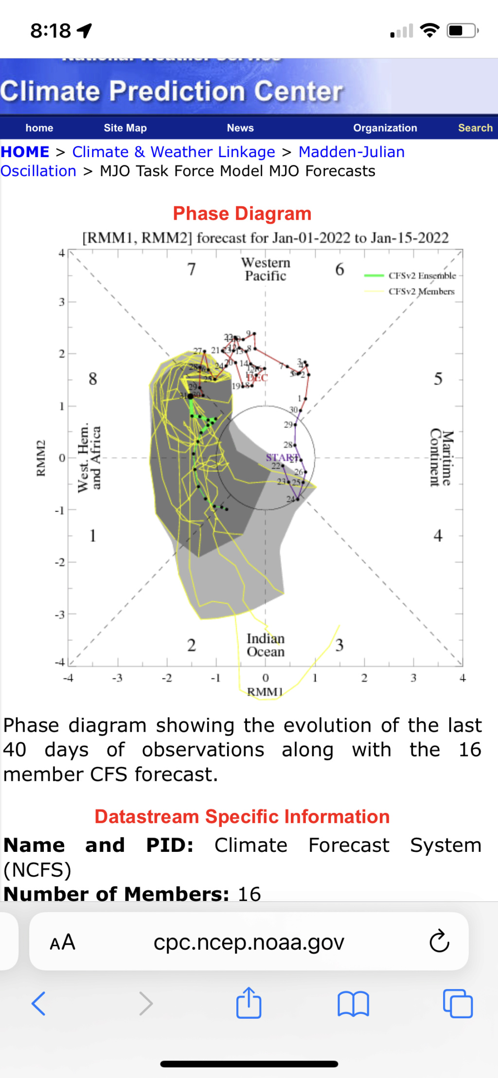
amugs wrote:Rb interesting you posted the CFSv2 because I have been watching that model runs for a week plus now and it has been adamant about the wave going full blown Nina molasses through what the LR MOLLER maps I posted are indicating down the road.
"Build it ...and Cold n Snow ...wil come"
Or CP and Snow will come !!!!
All great information.
And I am harping on my call from mid month if not earlier that we see a NESIS thatb2nd orb3rdbweek of Jan to kick the winters arse!!
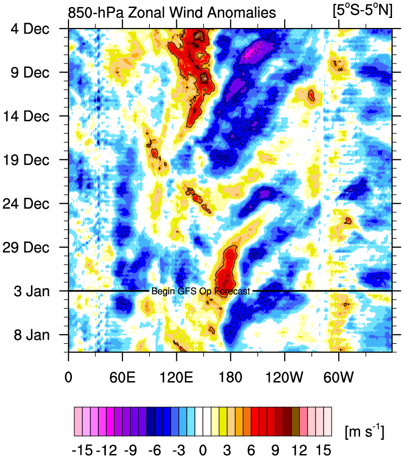
I’ve ignored it until now because it has a bias of being overly ambitious with propagating the MJO too quickly and too strongly. It always shows an amplified full rotation through the phases. Up until now, I knew that would not be the case based on the forcing mechanisms, so I didn’t pay attention. However, now that those forcing mechanisms are different, I think it has the best representation of the MJO progression, and the other models are steadily correcting towards it.
rb924119- Meteorologist

- Posts : 7042
Reputation : 195
Join date : 2013-02-06
Age : 32
Location : Greentown, Pa
 Re: Long Range Discussion 22.0

Irish- Pro Enthusiast

- Posts : 788
Reputation : 19
Join date : 2019-01-16
Age : 46
Location : Old Bridge, NJ
rb924119 likes this post
 Re: Long Range Discussion 22.0
Irish wrote:I think someone else mentioned it already but what about the smaller snow threat on 1/7?
Very good question Irish. That’s less than a week away, so it would usually be highly discussed at this point. But of course, Monday has everyone’s attention at the moment.
My TWC app shows 1-3” for both Thurs night and Friday morning. In my world, that’s a perfect indication that we’re in good shape this far out. The latest GFS shows a range of 5-9” for our board. Someone here mentioned earlier that r/s lines and snowfall projections are a bit premature. Probably bc what happens Monday will clear up the picture a good deal.
So, in general, I’d say the threat appears to be alive and well. Hope that helps!
SENJsnowman- Senior Enthusiast

- Posts : 1197
Reputation : 61
Join date : 2017-01-06
Age : 51
Location : Long Branch, NJ
rb924119 likes this post
rb924119- Meteorologist

- Posts : 7042
Reputation : 195
Join date : 2013-02-06
Age : 32
Location : Greentown, Pa
 Re: Long Range Discussion 22.0
Irish wrote:I think someone else mentioned it already but what about the smaller snow threat on 1/7?
What Snowman said haha the 1/7 threat is just that; a legitimate threat. I’m sure it will get its own thread before too long, but the focus of most is on what’s front and center right now
rb924119- Meteorologist

- Posts : 7042
Reputation : 195
Join date : 2013-02-06
Age : 32
Location : Greentown, Pa
 Re: Long Range Discussion 22.0
As much as I want snow friday and sat couldnt be worse timing, due to covid we missed seeing my family where many of my daughters gifts are and we are supposed to visit them saturday in CT, now I am a really good driver in the snow but it is the others i worry about and if we do not make it my daughter and us will be really upset. So lets make it on the 7th and clear up for morning of 8th would be perfect : ) Got it rb? Make it happen lolrb924119 wrote:Irish wrote:I think someone else mentioned it already but what about the smaller snow threat on 1/7?
What Snowman said haha the 1/7 threat is just that; a legitimate threat. I’m sure it will get its own thread before too long, but the focus of most is on what’s front and center right now

jmanley32- Senior Enthusiast

- Posts : 20639
Reputation : 108
Join date : 2013-12-12
Age : 43
Location : Yonkers, NY
 Re: Long Range Discussion 22.0
The most impactful system of interest in the medium range looks to affect the region Thursday night into Friday. The deterministic solutions all feature a digging trough into the Midwest Thursday
night, becoming negatively tilted by Friday, with a developing surface low moving through the Appalachians into the Mid-Atlantic. The individual models appear to be exhibiting some typical biases,
with the GFS the most progressive and suppressed and the ECMWF farther northwest and a little slower to intensify. The CMC is the middle-ground solution (though stronger, and also by far the most
problematic for our CWA, with warning-level snows projected in much of the region). Notably, model variability is sufficiently high and run-to-run continuity is sufficiently poor to point out that this
event is by no means a slam dunk for our area...the GFS and ECMWF would indicate two failure modes for most of our area, for example.
However, pattern recognition suggests this is a setup favorable for impactful snow somewhere in the Mid-Atlantic and Northeast, and the tendency of the digging trough to become negatively-tilted would
suggest to me that farther northwest solutions would be favored (unlike the GFS trend, e.g.). Will definitely need to keep an eye on this system, with plenty of time to sift out the noise from the real
model trends.
For reference, here is the Canadian 12z:
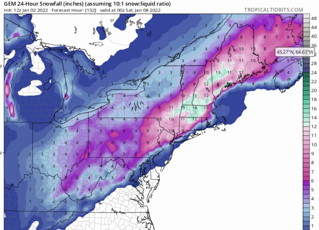
That would certainly for make for a great for week for the whole board!
SENJsnowman- Senior Enthusiast

- Posts : 1197
Reputation : 61
Join date : 2017-01-06
Age : 51
Location : Long Branch, NJ
 Re: Long Range Discussion 22.0
_________________
Mugs
AKA:King: Snow Weenie
Self Proclaimed
WINTER 2014-15 : 55.12" +.02 for 6 coatings (avg. 35")
WINTER 2015-16 Total - 29.8" (Avg 35")
WINTER 2016-17 : 39.5" so far

amugs- Advanced Forecaster - Mod

- Posts : 15133
Reputation : 213
Join date : 2013-01-07
Age : 54
Location : Hillsdale,NJ
 Re: Long Range Discussion 22.0

Irish- Pro Enthusiast

- Posts : 788
Reputation : 19
Join date : 2019-01-16
Age : 46
Location : Old Bridge, NJ
 Re: Long Range Discussion 22.0
Irish wrote:TWC is calling for 4-6 inches in my area Thursday night into Friday morning. Getting pumped here!
The 6/7th is legit for a significant to major storm. All models have a storm signal except of course the GooFuS. Still 5 days out so details have to be worked out but it looks good right now.

hyde345- Pro Enthusiast

- Posts : 1082
Reputation : 48
Join date : 2013-01-08
Location : Hyde Park, NY
weatherwatchermom likes this post
 Re: Long Range Discussion 22.0
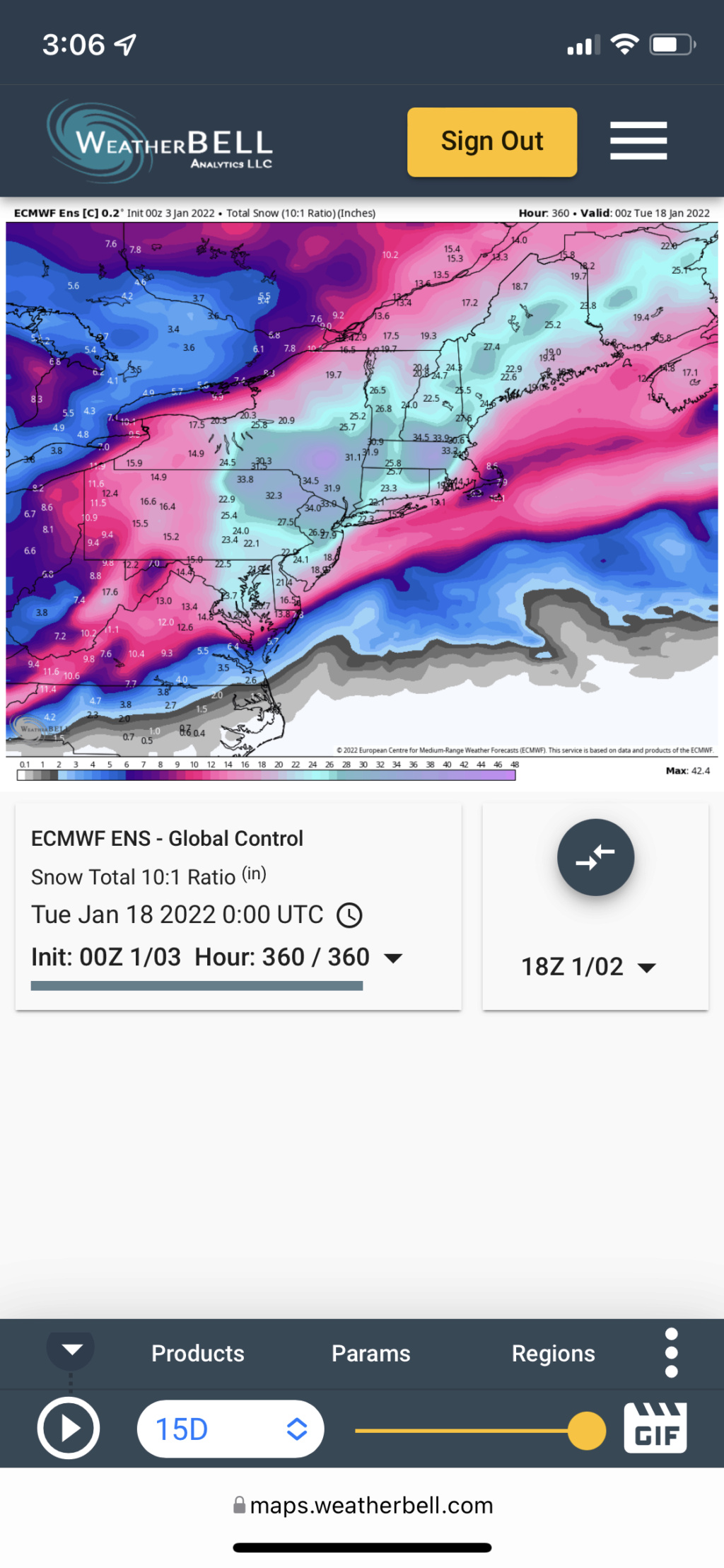
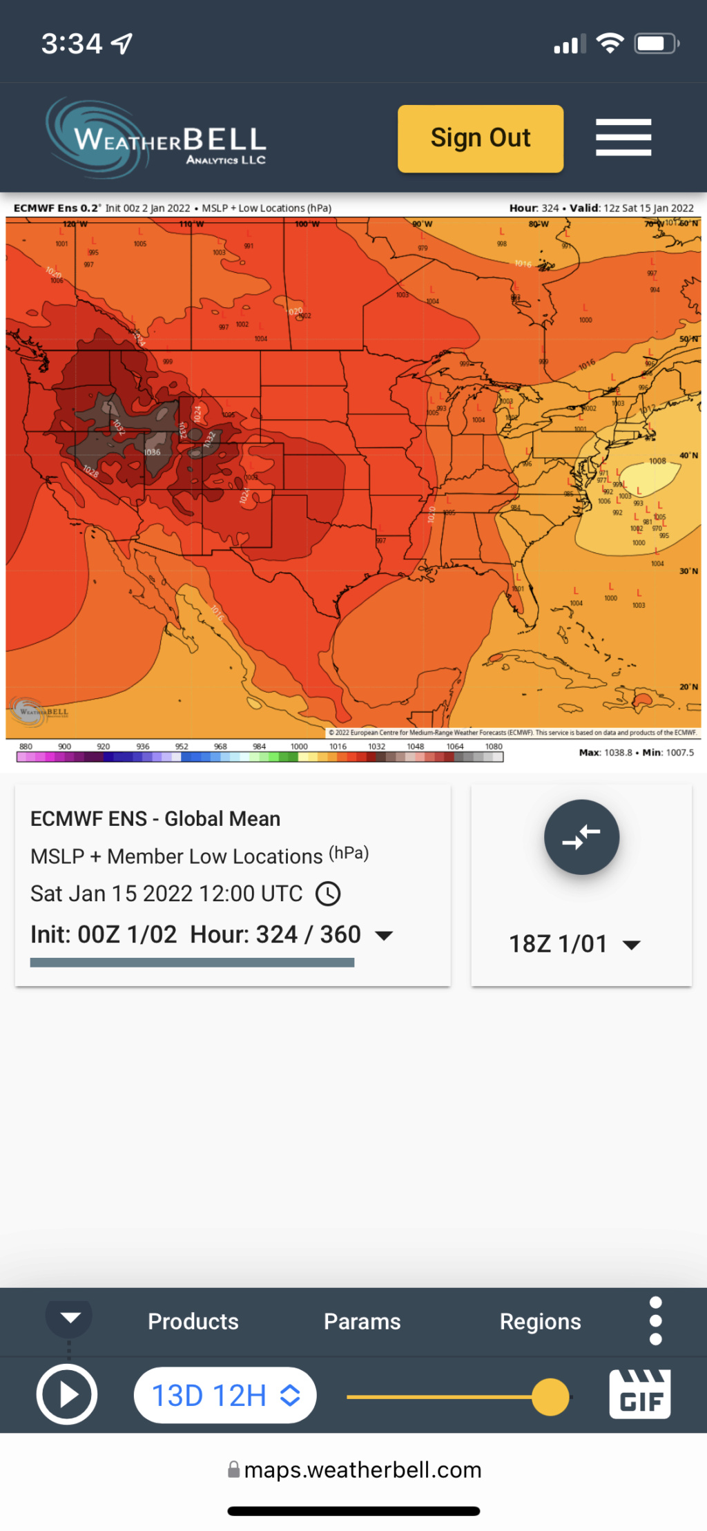
This is its rendition of the 13th-16th potential (minus about 8 inches on average for everybody, since it also includes today’s and Friday’s events). However, even though the snowfall maps aren’t showing it, the sea level pressure maps across the ensembles (GEFS, GEPS and EPS all have a similar signature):
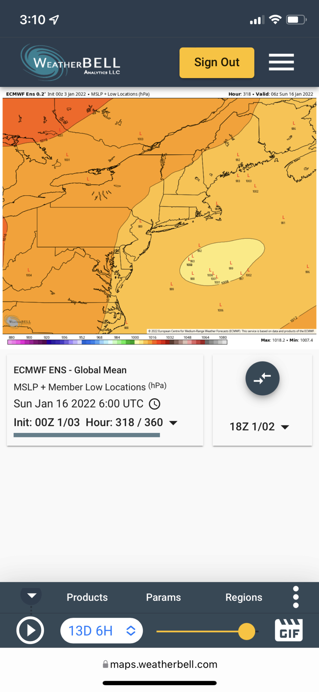
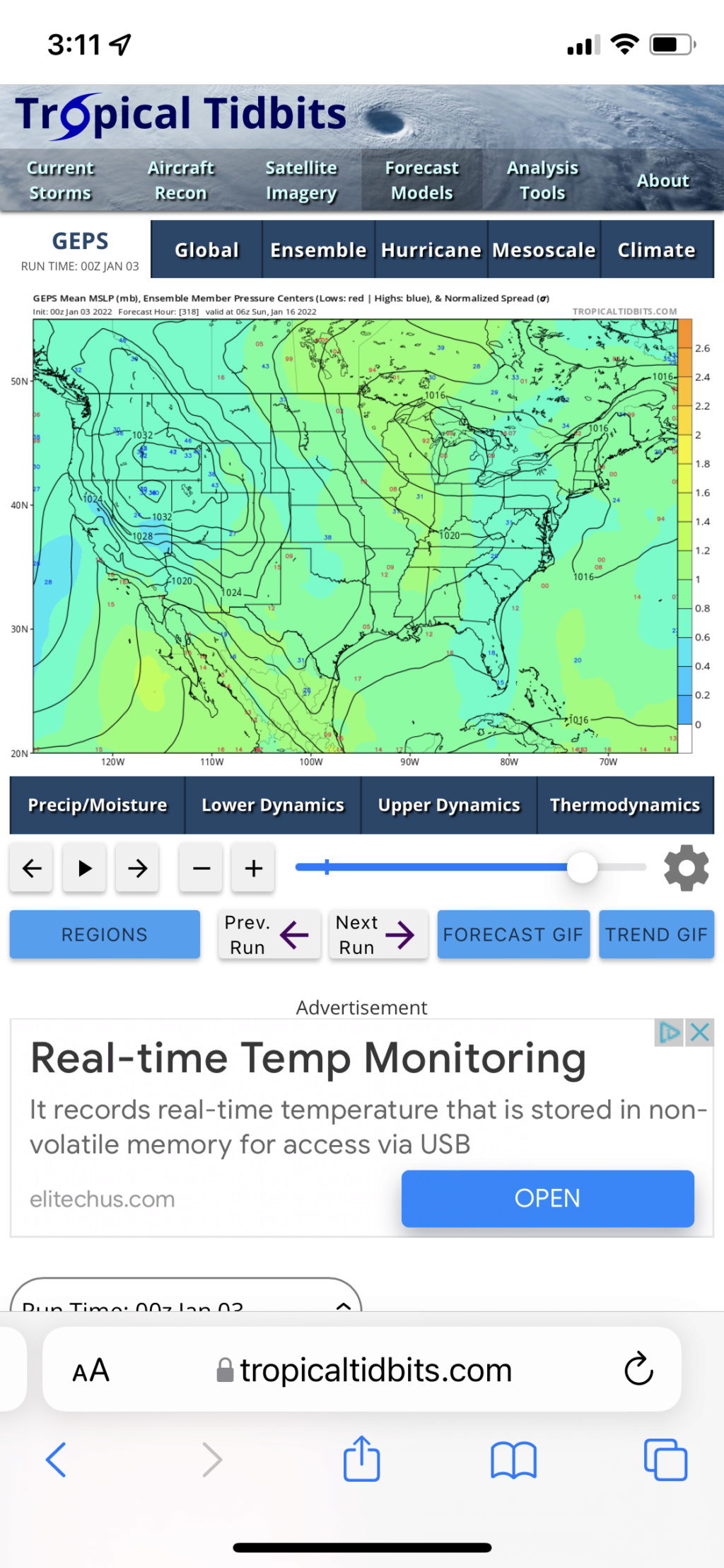
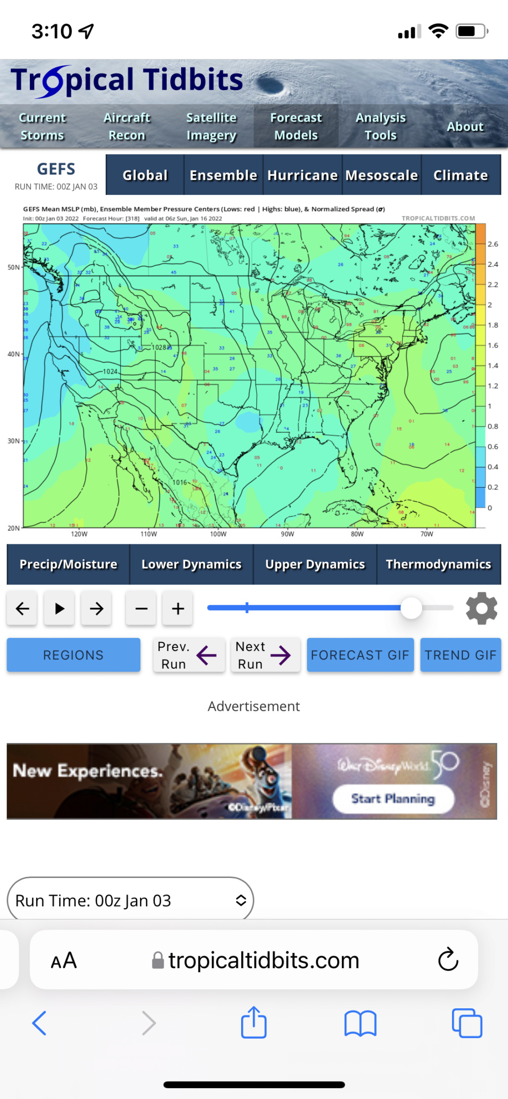
And their H5 depictions support it BIGLY. Today is the hors d’oeuvres, Friday could be the appetizer, and the 13th-16th threat will be the main course
Trust the process folks.
rb924119- Meteorologist

- Posts : 7042
Reputation : 195
Join date : 2013-02-06
Age : 32
Location : Greentown, Pa
amugs and weatherwatchermom like this post
 Re: Long Range Discussion 22.0
I must say for some years we had Dec 1, 8, etc. snow storms and I was spoiled. Those were my expectations. Then I learned if Dec starts out with a bang, the rest of the winter could be meh. I like the foregoing of the snow in Dec if the long range gives us victory.

dkodgis- Senior Enthusiast

- Posts : 2671
Reputation : 98
Join date : 2013-12-29
rb924119 likes this post
 Re: Long Range Discussion 22.0
Irish wrote:TWC is calling for 4-6 inches in my area Thursday night into Friday morning. Getting pumped here!
I've been discussing it in the January discussions channel. It's the most legit threat for the I-95/and NW that we've had all season. It depends on where baroclinic zone sets up as to who gets what, but I like the H5 look and the consensus among the ensembles.
heehaw453- Advanced Forecaster

- Posts : 3916
Reputation : 86
Join date : 2014-01-20
Location : Bedminster Township, PA Elevation 600' ASL
rb924119 likes this post
 Re: Long Range Discussion 22.0
Finally starting to see the emergence of an Alaskan ridge, which will release the floodgates on some of the very cold air that has been locked up in western North America.
— Ben Noll (@BenNollWeather) January 2, 2022
Tropical convection favoring RMM phase 7/8 and the atmospheric response for the U.S. looks classic. pic.twitter.com/UWcNL5CW9o
Phase 8

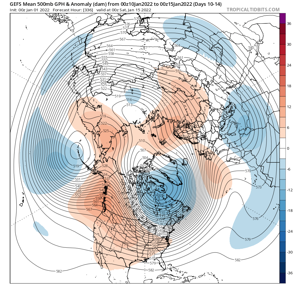
Cross polar flow with a Negative EPO, AO and Positive PNA - yes NAO is Positive but this is a workable pattern - much better than what were are in now!!
What we've been harping on here for 2 weeks now.
_________________
Mugs
AKA:King: Snow Weenie
Self Proclaimed
WINTER 2014-15 : 55.12" +.02 for 6 coatings (avg. 35")
WINTER 2015-16 Total - 29.8" (Avg 35")
WINTER 2016-17 : 39.5" so far

amugs- Advanced Forecaster - Mod

- Posts : 15133
Reputation : 213
Join date : 2013-01-07
Age : 54
Location : Hillsdale,NJ
rb924119 and heehaw453 like this post
 Re: Long Range Discussion 22.0
_________________
Mugs
AKA:King: Snow Weenie
Self Proclaimed
WINTER 2014-15 : 55.12" +.02 for 6 coatings (avg. 35")
WINTER 2015-16 Total - 29.8" (Avg 35")
WINTER 2016-17 : 39.5" so far

amugs- Advanced Forecaster - Mod

- Posts : 15133
Reputation : 213
Join date : 2013-01-07
Age : 54
Location : Hillsdale,NJ
rb924119 likes this post
 Re: Long Range Discussion 22.0
_________________
Mugs
AKA:King: Snow Weenie
Self Proclaimed
WINTER 2014-15 : 55.12" +.02 for 6 coatings (avg. 35")
WINTER 2015-16 Total - 29.8" (Avg 35")
WINTER 2016-17 : 39.5" so far

amugs- Advanced Forecaster - Mod

- Posts : 15133
Reputation : 213
Join date : 2013-01-07
Age : 54
Location : Hillsdale,NJ
rb924119 and MattyICE like this post
 Re: Long Range Discussion 22.0
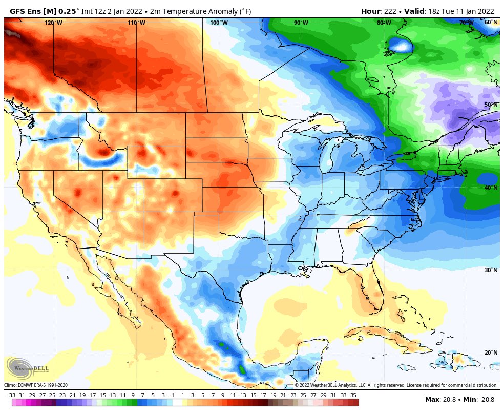
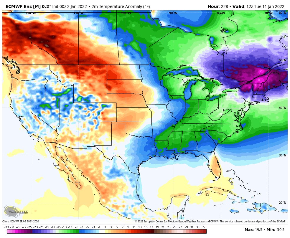
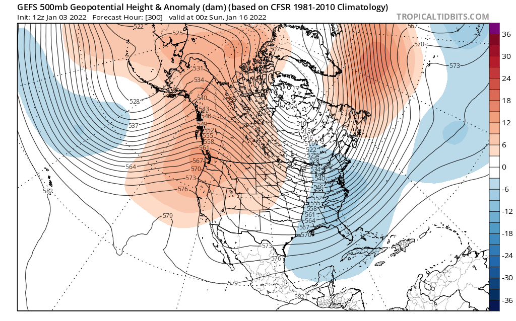
amugs wrote:Paging Rb!!! Here's your pattern and our storm potential!
LOCK. IT. IN.
Don’t be surprised if we see a pseudo -NAO during this period too. A lot of people are going to say “look at Greenland”, and “look at the charts”, but just because the atmosphere doesn’t project well onto our subjective diagrams, doesn’t mean that it won’t behave in a similar manner even though it has a non-textbook appearance. If this occurs, then it only adds to the potential. If I don’t go up north at the end of this week, then I’ll put out a video explaining what I’ve been seeing for the last several days that has me so excited.
rb924119- Meteorologist

- Posts : 7042
Reputation : 195
Join date : 2013-02-06
Age : 32
Location : Greentown, Pa
 Re: Long Range Discussion 22.0

_________________
Mugs
AKA:King: Snow Weenie
Self Proclaimed
WINTER 2014-15 : 55.12" +.02 for 6 coatings (avg. 35")
WINTER 2015-16 Total - 29.8" (Avg 35")
WINTER 2016-17 : 39.5" so far

amugs- Advanced Forecaster - Mod

- Posts : 15133
Reputation : 213
Join date : 2013-01-07
Age : 54
Location : Hillsdale,NJ
rb924119 likes this post
 Re: Long Range Discussion 22.0

Snow88- Senior Enthusiast

- Posts : 2193
Reputation : 4
Join date : 2013-01-09
Age : 36
Location : Brooklyn, NY
rb924119 likes this post
 Re: Long Range Discussion 22.0
There also might be a threat of a big storm mid month but that's too far out to talk about it..

Snow88- Senior Enthusiast

- Posts : 2193
Reputation : 4
Join date : 2013-01-09
Age : 36
Location : Brooklyn, NY
rb924119 likes this post
 Re: Long Range Discussion 22.0
Snow88 wrote:Holy PNA in the long range
There also might be a threat of a big storm mid month but that's too far out to talk about it..
That’s the one mugsy and I have been barking at for almost a week now (though the foundation was laid a long time before that). Now that the models are finally seeing the proper pattern evolution, they will start (and have already started) to pick up on the actual storm threat itself.
rb924119- Meteorologist

- Posts : 7042
Reputation : 195
Join date : 2013-02-06
Age : 32
Location : Greentown, Pa
 Re: Long Range Discussion 22.0
_________________
Mugs
AKA:King: Snow Weenie
Self Proclaimed
WINTER 2014-15 : 55.12" +.02 for 6 coatings (avg. 35")
WINTER 2015-16 Total - 29.8" (Avg 35")
WINTER 2016-17 : 39.5" so far

amugs- Advanced Forecaster - Mod

- Posts : 15133
Reputation : 213
Join date : 2013-01-07
Age : 54
Location : Hillsdale,NJ
rb924119 likes this post
Page 20 of 31 •  1 ... 11 ... 19, 20, 21 ... 25 ... 31

 Home
Home

