Long Range Discussion 22.0
+33
skinsfan1177
chief7
WeatherBob
emokid51783
hyde345
jmanley32
dsix85
jaydoy
billg315
lglickman1
CPcantmeasuresnow
Snow88
mmanisca
phil155
weatherwatchermom
Dunnzoo
nutleyblizzard
Radz
Irish
Wheezer
Math23x7
rb924119
SENJsnowman
heehaw453
algae888
aiannone
MattyICE
frank 638
Frank_Wx
docstox12
dkodgis
amugs
sroc4
37 posters
Page 27 of 31
Page 27 of 31 •  1 ... 15 ... 26, 27, 28, 29, 30, 31
 Re: Long Range Discussion 22.0
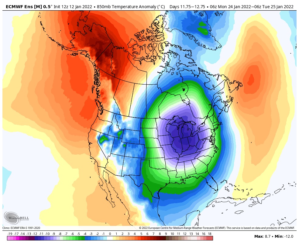
Momma Mia that is one hell of a arctic outbreak forecasted- Grid gonna be taxed like Docstox when he trades Nat Gas!!!


amugs- Advanced Forecaster - Mod

- Posts : 15130
Join date : 2013-01-07
 Re: Long Range Discussion 22.0
A little nervous the PV gets too far south from a stormy standpoint. But yea, that is a verrrry cold look. Record breaking.
phil155 likes this post
 Re: Long Range Discussion 22.0
Frank_Wx wrote:A little nervous the PV gets too far south from a stormy standpoint. But yea, that is a verrrry cold look. Record breaking.
Cold and dry is no fun at all
phil155- Pro Enthusiast

- Posts : 494
Reputation : 4
Join date : 2019-12-16
 Re: Long Range Discussion 22.0
No it's not but let it happen first before we go to that rabbit hole. In the meantime here in next weekend.


_________________
Mugs
AKA:King: Snow Weenie
Self Proclaimed
WINTER 2014-15 : 55.12" +.02 for 6 coatings (avg. 35")
WINTER 2015-16 Total - 29.8" (Avg 35")
WINTER 2016-17 : 39.5" so far

amugs- Advanced Forecaster - Mod

- Posts : 15130
Reputation : 213
Join date : 2013-01-07
Age : 54
Location : Hillsdale,NJ
rb924119- Meteorologist

- Posts : 7040
Reputation : 195
Join date : 2013-02-06
Age : 32
Location : Greentown, Pa
 Re: Long Range Discussion 22.0
If the storm on Monday does not pan out, the next time period to watch is 21st through 28th. Especially 21st-22nd and 25th-27th. No doubt we will have the cold air. Question will be can we get the critical pieces of upper air features to be placed favorably. We need the EPO, PNA, AO and NAO ridges in the right spots. It's one thing for them to be negative (or positive) but if they are oriented in a way that disrupts the overall flow then we won't see anything come together.
_________________
_______________________________________________________________________________________________________
CLICK HERE to view NJ Strong Snowstorm Classifications
phil155 likes this post
 Re: Long Range Discussion 22.0
I have found predicting this #winter to be challenging so why should February be any different? GFS has been suggesting a bit more confidently yet another stretched #PolarVortex as we approach February. Would certainly bias #colder East US but cold polar cap heights keep me wary pic.twitter.com/avGQsN7foE
— Judah Cohen (@judah47) January 14, 2022
_________________
Mugs
AKA:King: Snow Weenie
Self Proclaimed
WINTER 2014-15 : 55.12" +.02 for 6 coatings (avg. 35")
WINTER 2015-16 Total - 29.8" (Avg 35")
WINTER 2016-17 : 39.5" so far

amugs- Advanced Forecaster - Mod

- Posts : 15130
Reputation : 213
Join date : 2013-01-07
Age : 54
Location : Hillsdale,NJ
 Re: Long Range Discussion 22.0
Seems the 12z gfs picked back up on the signal for next weekend. Looked rather enticing in fact. (Oh lord help me lol)
SENJsnowman- Senior Enthusiast

- Posts : 1197
Reputation : 61
Join date : 2017-01-06
Age : 51
Location : Long Branch, NJ
amugs likes this post
 Re: Long Range Discussion 22.0
Aside from a possibly good looking pattern, are there any storm signals that are evolving favorably? I know TWC isn't the greatest but there doesn't seem to be anything on the horizon until maybe the end of the month
lglickman1- Pro Enthusiast

- Posts : 319
Reputation : 0
Join date : 2013-02-05
Location : New Rochelle, NY
 Re: Long Range Discussion 22.0
Larry, here's my take. After 2 or 3 consistent GFS runs, I think the result shows up on TWC. And then after 2-3 runs of not showing up on the GFS, TWC drops the storm from the forecast. Same thing as far the amounts of precip, storm timing etc...
Just looking at the recent and present gfs operational runs, there has been a signal for a clipper midweek, a storm that misses to our south late week and then a potential coastal storm for next Sat/Sun. They've all looked decent on individual prior runs the last few days and all look like hot poo as of now, at least on the GFS.
So, I think after this weekend's last system clears out on Monday, the potential for anything next week will emerge more clearly on the models.
Also, we are just now, as of today, entering the third week of January. Rb wan kenobi was very steadfast in his assessment that this is when the active period first begins. Finally, plenty of cold air for next week, and that's the one ingredient that needs to be there from the start I guess.
OK, there's my optimistic attempt at answering your question from a total novice-weenie.
SENJsnowman- Senior Enthusiast

- Posts : 1197
Reputation : 61
Join date : 2017-01-06
Age : 51
Location : Long Branch, NJ
 Re: Long Range Discussion 22.0
SENJsnowman wrote:Larry, here's my take. After 2 or 3 consistent GFS runs, I think the result shows up on TWC. And then after 2-3 runs of not showing up on the GFS, TWC drops the storm from the forecast. Same thing as far the amounts of precip, storm timing etc...
Just looking at the recent and present gfs operational runs, there has been a signal for a clipper midweek, a storm that misses to our south late week and then a potential coastal storm for next Sat/Sun. They've all looked decent on individual prior runs the last few days and all look like hot poo as of now, at least on the GFS.
So, I think after this weekend's last system clears out on Monday, the potential for anything next week will emerge more clearly on the models.
Also, we are just now, as of today, entering the third week of January. Rb wan kenobi was very steadfast in his assessment that this is when the active period first begins. Finally, plenty of cold air for next week, and that's the one ingredient that needs to be there from the start I guess.
OK, there's my optimistic attempt at answering your question from a total novice-weenie.
Thanks, let's hope something comes together for us
lglickman1- Pro Enthusiast

- Posts : 319
Reputation : 0
Join date : 2013-02-05
Location : New Rochelle, NY
SENJsnowman likes this post
 Re: Long Range Discussion 22.0
Frank_Wx wrote:If the storm on Monday does not pan out, the next time period to watch is 21st through 28th. Especially 21st-22nd and 25th-27th. No doubt we will have the cold air. Question will be can we get the critical pieces of upper air features to be placed favorably. We need the EPO, PNA, AO and NAO ridges in the right spots. It's one thing for them to be negative (or positive) but if they are oriented in a way that disrupts the overall flow then we won't see anything come together.
These time periods still remain of interest. The wave on the 21st probably not, but we have one on the 23rd and still the one I like the most near the 25th. I won’t talk much beyond that…but I’m still not completely sold on February. If anything, I see the dreaded -PNA trying to make a comeback

_________________
_______________________________________________________________________________________________________
CLICK HERE to view NJ Strong Snowstorm Classifications
 Re: Long Range Discussion 22.0
Frank_Wx wrote:Frank_Wx wrote:If the storm on Monday does not pan out, the next time period to watch is 21st through 28th. Especially 21st-22nd and 25th-27th. No doubt we will have the cold air. Question will be can we get the critical pieces of upper air features to be placed favorably. We need the EPO, PNA, AO and NAO ridges in the right spots. It's one thing for them to be negative (or positive) but if they are oriented in a way that disrupts the overall flow then we won't see anything come together.
These time periods still remain of interest. The wave on the 21st probably not, but we have one on the 23rd and still the one I like the most near the 25th. I won’t talk much beyond that…but I’m still not completely sold on February. If anything, I see the dreaded -PNA trying to make a comeback
Alright, so this winter is almost over, lol! Just kidding.

Irish- Pro Enthusiast

- Posts : 788
Reputation : 19
Join date : 2019-01-16
Age : 46
Location : Old Bridge, NJ
 Re: Long Range Discussion 22.0
18z GFS with a bomb day 7 snowstorm.

nutleyblizzard- Senior Enthusiast

- Posts : 1963
Reputation : 41
Join date : 2014-01-30
Age : 58
Location : Nutley, new jersey
 Re: Long Range Discussion 22.0
At least it's something to hope for...nutleyblizzard wrote:18z GFS with a bomb day 7 snowstorm.

Irish- Pro Enthusiast

- Posts : 788
Reputation : 19
Join date : 2019-01-16
Age : 46
Location : Old Bridge, NJ
 Re: Long Range Discussion 22.0
No, just no stop lolnutleyblizzard wrote:18z GFS with a bomb day 7 snowstorm.

jmanley32- Senior Enthusiast

- Posts : 20638
Reputation : 108
Join date : 2013-12-12
Age : 43
Location : Yonkers, NY
 Re: Long Range Discussion 22.0
18z GFS has the tip of florida panhandle with a foot of snow....theres just nothing right about that, we arent getting good snows but florida is

jmanley32- Senior Enthusiast

- Posts : 20638
Reputation : 108
Join date : 2013-12-12
Age : 43
Location : Yonkers, NY
 Re: Long Range Discussion 22.0
Looking forward to seeing what's in store between the 25th-26th and 28th-29th.

Irish- Pro Enthusiast

- Posts : 788
Reputation : 19
Join date : 2019-01-16
Age : 46
Location : Old Bridge, NJ
 Re: Long Range Discussion 22.0
Come on people wake up the euro just dropped a bomb on us
Last edited by chief7 on Sun Jan 16, 2022 2:00 am; edited 1 time in total
chief7- Posts : 132
Reputation : 0
Join date : 2013-11-10
Location : Langhorne pa
 Re: Long Range Discussion 22.0
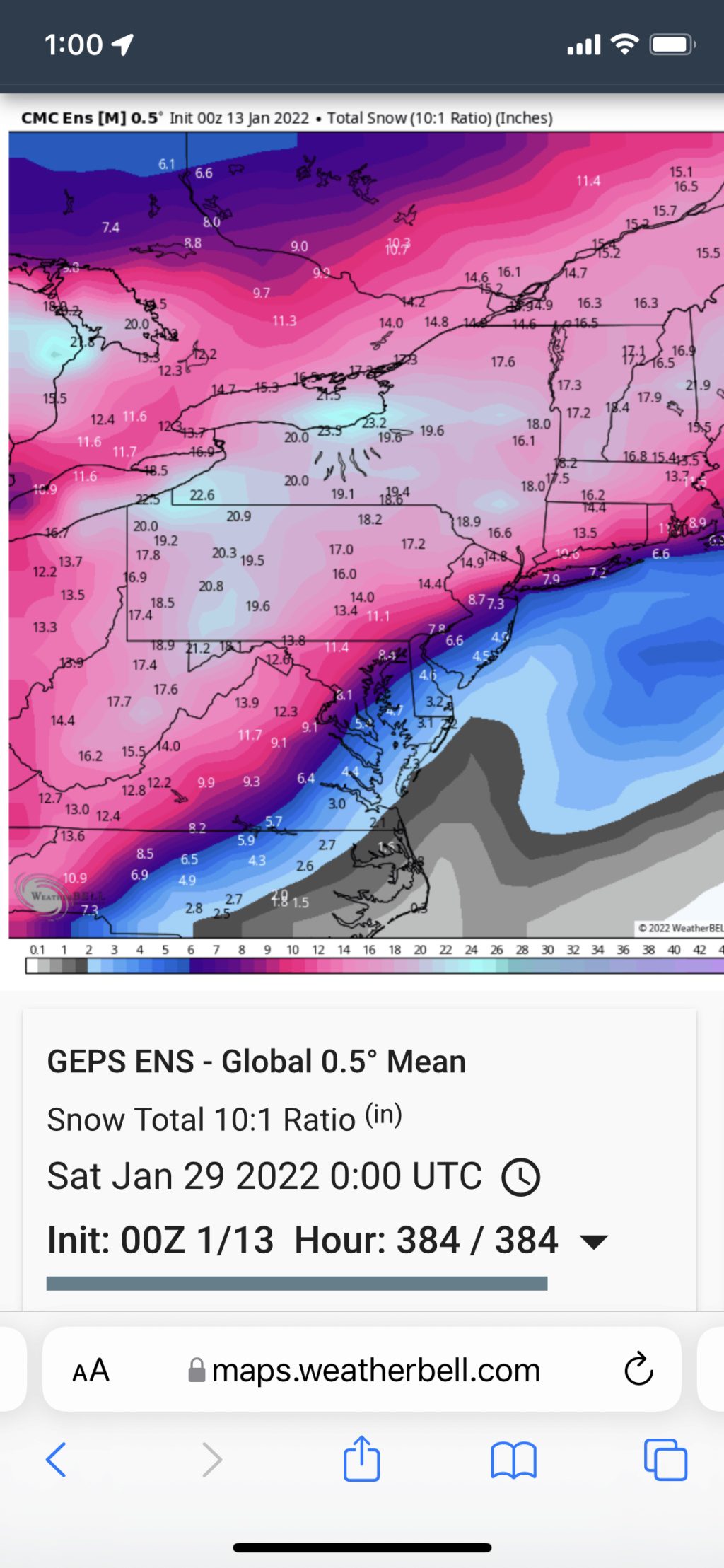
CMC gives us a complete hecs for the 22nd!!
adamfitz1969- Posts : 122
Reputation : 14
Join date : 2018-03-01
Age : 54
Location : Tarrytown
 Re: Long Range Discussion 22.0
Actually it was the euro and it’s for late Friday night early Saturday morningadamfitz1969 wrote:CMC gives us a complete hecs for the 22nd!!
chief7- Posts : 132
Reputation : 0
Join date : 2013-11-10
Location : Langhorne pa
 Re: Long Range Discussion 22.0
chief7 wrote:Actually it was the euro and it’s for late Friday night early Saturday morningadamfitz1969 wrote:CMC gives us a complete hecs for the 22nd!!
Thank you for the correction! Im surprised no one is commenting on those runs!
adamfitz1969- Posts : 122
Reputation : 14
Join date : 2018-03-01
Age : 54
Location : Tarrytown
chief7 likes this post
 Re: Long Range Discussion 22.0
I didn’t comment cause I can’t see the EURO run. Tropical Tidbits says the EURO server is down.adamfitz1969 wrote:chief7 wrote:Actually it was the euro and it’s for late Friday night early Saturday morningadamfitz1969 wrote:CMC gives us a complete hecs for the 22nd!!
Thank you for the correction! Im surprised no one is commenting on those runs!

nutleyblizzard- Senior Enthusiast

- Posts : 1963
Reputation : 41
Join date : 2014-01-30
Age : 58
Location : Nutley, new jersey
 Re: Long Range Discussion 22.0
chief7 wrote:Come on people wake up the euro just dropped a bomb on us
Nice to see a storm signal there but way too soon to predict what will happen here.Look at this current storm, it was OTS, then a big hit, now a slop rain storm.This morning I can see pretty clearly what will happen.I will do the same with this upcoming storm signal, wait until a day before and the day of the storm before getting psyched up.

docstox12- Wx Statistician Guru

- Posts : 8597
Reputation : 222
Join date : 2013-01-07
Age : 73
Location : Monroe NY
moleson likes this post
 Re: Long Range Discussion 22.0

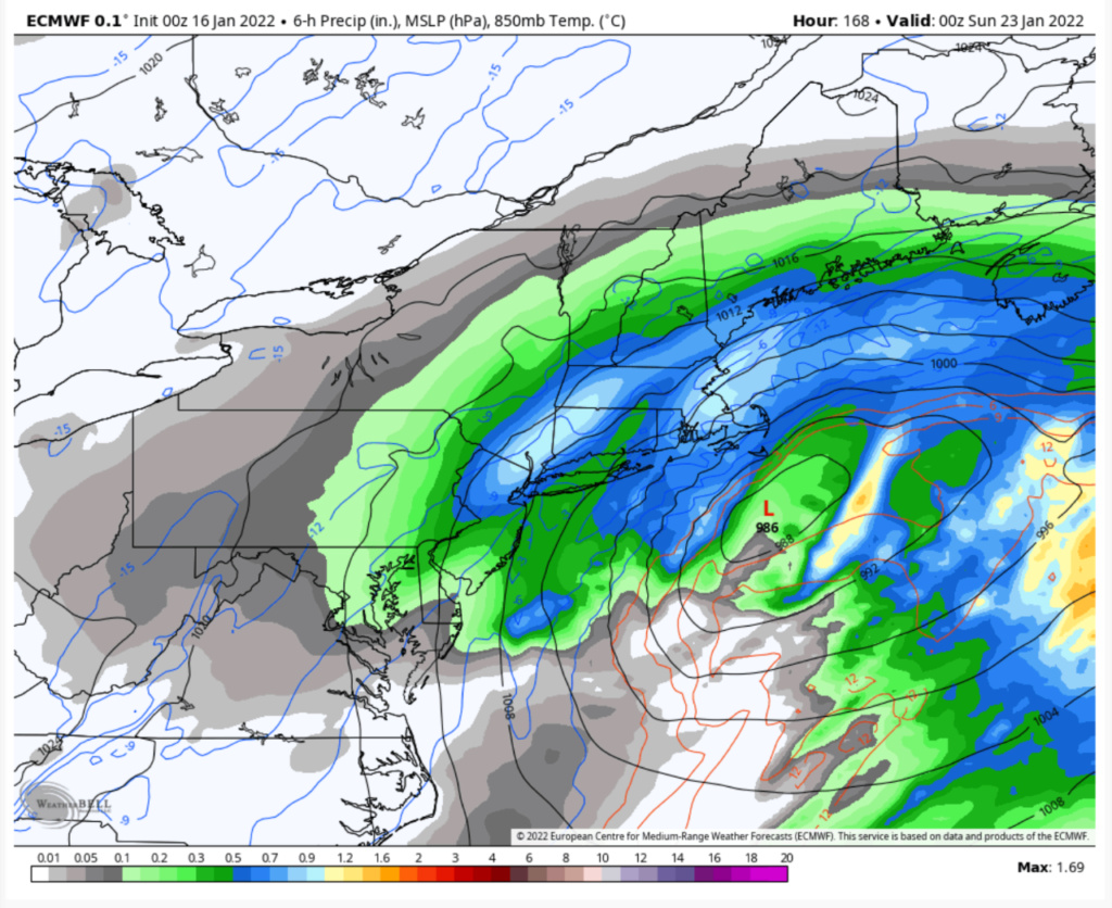
Aha there it is. Taken verbatim with 1.5 QPF with temps in the teens during the event it’s a 2 footer. CMC shows a huge hit as well. GFS shows a very strong storm although OTS. The difference with next weekends potential compared to tomorrows rainstorm is that we have a high in the right spot this time. Currently the models see the Day 6 potential then lose it only to bring it back again. Plenty of time to track, but after last nights Euro and CMC runs I’m sure Frank will have a more detailed discussion on it.

nutleyblizzard- Senior Enthusiast

- Posts : 1963
Reputation : 41
Join date : 2014-01-30
Age : 58
Location : Nutley, new jersey
 Re: Long Range Discussion 22.0
wow that deayh band right over my house, ill take 1 for me plz. Not getting sucking in though, thursday.nutleyblizzard wrote:
Aha there it is. Taken verbatim with 1.5 QPF with temps in the teens during the event it’s a 2 footer. CMC shows a huge hit as well. GFS shows a very strong storm although OTS. The difference with next weekends potential compared to tomorrows rainstorm is that we have a high in the right spot this time. Currently the models see the Day 6 potential then lose it only to bring it back again. Plenty of time to track, but after last nights Euro and CMC runs I’m sure Frank will have a more detailed discussion on it.

jmanley32- Senior Enthusiast

- Posts : 20638
Reputation : 108
Join date : 2013-12-12
Age : 43
Location : Yonkers, NY
 Re: Long Range Discussion 22.0
jmanley32 wrote:wow that deayh band right over my house, ill take 1 for me plz. Not getting sucking in though, thursday.nutleyblizzard wrote:
Aha there it is. Taken verbatim with 1.5 QPF with temps in the teens during the event it’s a 2 footer. CMC shows a huge hit as well. GFS shows a very strong storm although OTS. The difference with next weekends potential compared to tomorrows rainstorm is that we have a high in the right spot this time. Currently the models see the Day 6 potential then lose it only to bring it back again. Plenty of time to track, but after last nights Euro and CMC runs I’m sure Frank will have a more detailed discussion on it.
Good call Jon! As for myself, I’ll be getting sucked in. Probably in the next 24 hours, if the signal persists…
SENJsnowman- Senior Enthusiast

- Posts : 1197
Reputation : 61
Join date : 2017-01-06
Age : 51
Location : Long Branch, NJ
Page 27 of 31 •  1 ... 15 ... 26, 27, 28, 29, 30, 31
Page 27 of 31
Permissions in this forum:
You cannot reply to topics in this forum
 Home
Home
