
 Search
Tracking JAN 29th 2022 'The Phase'
Page 23 of 31 •  1 ... 13 ... 22, 23, 24 ... 27 ... 31
 ![]()
Re: Tracking JAN 29th 2022 'The Phase'
![]() by Frank_Wx Thu Jan 27, 2022 1:07 pm
by Frank_Wx Thu Jan 27, 2022 1:07 pm
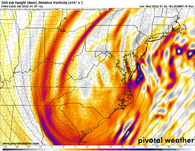
12Z SATURDAY
I TOLD MUGS AND JANET YESTERDAY WE NEED THIS TO CLOSE OFF AT 09Z. WE ARE 3 HOURS AWAY FROM IT. MADONNA MIA!!!!!!!!!!!!!!!!!!!

Frank_Wx- Godzilla Seeker

- Posts : 21305
Join date : 2013-01-05 -

Bwtr and DWay like this post
Re: Tracking JAN 29th 2022 'The Phase'
![]() by Frank_Wx Thu Jan 27, 2022 1:08 pm
by Frank_Wx Thu Jan 27, 2022 1:08 pm
Frank_Wx- Godzilla Seeker
- Posts : 21305
Join date : 2013-01-05 -
Bwtr likes this post
Re: Tracking JAN 29th 2022 'The Phase'
![]() by bloc1357 Thu Jan 27, 2022 1:09 pm
by bloc1357 Thu Jan 27, 2022 1:09 pm
bloc1357- Pro Enthusiast

- Posts : 344
Reputation : 10
Join date : 2013-03-05
Age : 47
Location : West Babylon, NY - 11704
Re: Tracking JAN 29th 2022 'The Phase'
![]() by jmanley32 Thu Jan 27, 2022 1:10 pm
by jmanley32 Thu Jan 27, 2022 1:10 pm
such intricacies it is amazing. Were we further away than 3 hrs in past runs? That could be a eternity though in terms of a model run, this is so nail biting and probably will be till we see what happens at 09z lol oyFrank_Wx wrote:The EURO CLOSED H5 AT 48 HOURS
12Z SATURDAY
I TOLD MUGS AND JANET YESTERDAY WE NEED THIS TO CLOSE OFF AT 09Z. WE ARE 3 HOURS AWAY FROM IT. MADONNA MIA!!!!!!!!!!!!!!!!!!!

jmanley32- Senior Enthusiast

- Posts : 20595
Reputation : 108
Join date : 2013-12-12
Age : 43
Location : Yonkers, NY
Re: Tracking JAN 29th 2022 'The Phase'
![]() by Quietace Thu Jan 27, 2022 1:10 pm
by Quietace Thu Jan 27, 2022 1:10 pm

Quietace- Meteorologist - Mod

- Posts : 3689
Reputation : 33
Join date : 2013-01-07
Age : 27
Location : Point Pleasant, NJ
Re: Tracking JAN 29th 2022 'The Phase'
![]() by jmanley32 Thu Jan 27, 2022 1:11 pm
by jmanley32 Thu Jan 27, 2022 1:11 pm
I will join you tomorrow night if this busts, we arent far from each other, love to meet ya lolfrank 638 wrote:I think we should go get drinks this storm is driving everyone crazyFrank_Wx wrote:Not great trends on the EURO so far
jmanley32- Senior Enthusiast
- Posts : 20595
Reputation : 108
Join date : 2013-12-12
Age : 43
Location : Yonkers, NY
Re: Tracking JAN 29th 2022 'The Phase'
![]() by Frank_Wx Thu Jan 27, 2022 1:12 pm
by Frank_Wx Thu Jan 27, 2022 1:12 pm

_________________
_______________________________________________________________________________________________________
CLICK HERE to view NJ Strong Snowstorm Classifications

Frank_Wx- Godzilla Seeker
- Posts : 21305
Reputation : 328
Join date : 2013-01-05
Age : 32
Location : Jersey City, NJ -
Re: Tracking JAN 29th 2022 'The Phase'
![]() by Frank_Wx Thu Jan 27, 2022 1:15 pm
by Frank_Wx Thu Jan 27, 2022 1:15 pm
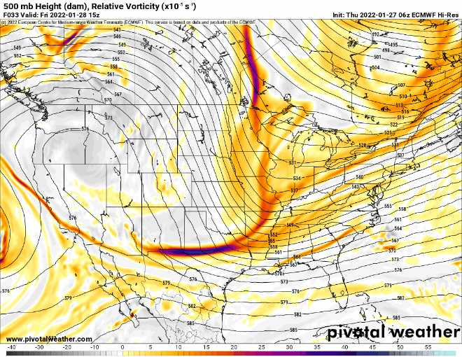
Quietace wrote:Still a double barrell low at the surface. Odd, and not entierly buying it, but we will see.
I think its the one model that does an OK job with holding onto a single primary

_________________
_______________________________________________________________________________________________________
CLICK HERE to view NJ Strong Snowstorm Classifications
Frank_Wx- Godzilla Seeker
- Posts : 21305
Reputation : 328
Join date : 2013-01-05
Age : 32
Location : Jersey City, NJ -
Re: Tracking JAN 29th 2022 'The Phase'
![]() by heehaw453 Thu Jan 27, 2022 1:16 pm
by heehaw453 Thu Jan 27, 2022 1:16 pm
Frank_Wx wrote:The EURO CLOSED H5 AT 48 HOURS
12Z SATURDAY
I TOLD MUGS AND JANET YESTERDAY WE NEED THIS TO CLOSE OFF AT 09Z. WE ARE 3 HOURS AWAY FROM IT. MADONNA MIA!!!!!!!!!!!!!!!!!!!
It's very close to being something much bigger Frank. It reconsolidation of the ULL that is causing this not be a big dog.
heehaw453- Advanced Forecaster

- Posts : 3906
Reputation : 86
Join date : 2014-01-20
Location : Bedminster Township, PA Elevation 600' ASL
Re: Tracking JAN 29th 2022 'The Phase'
![]() by sroc4 Thu Jan 27, 2022 1:17 pm
by sroc4 Thu Jan 27, 2022 1:17 pm
Quietace wrote:Still a double barrell low at the surface. Odd, and not entierly buying it, but we will see.
Hey Ryan. Nice to se you back. It looks like it’s chasing this convection. I bet that’s the reason for the double barrel slp. These little details ie exactly where these embedddd vorticies end up will be very diff to nail down in a model. Even this close.

_________________
"In weather and in life, there's no winning and losing; there's only winning and learning."
WINTER 2012/2013 TOTALS 43.65"WINTER 2017/2018 TOTALS 62.85" WINTER 2022/2023 TOTALS 4.9"
WINTER 2013/2014 TOTALS 64.85"WINTER 2018/2019 TOTALS 14.25" WINTER 2023/2024 TOTALS 13.1"
WINTER 2014/2015 TOTALS 71.20"WINTER 2019/2020 TOTALS 6.35"
WINTER 2015/2016 TOTALS 35.00"WINTER 2020/2021 TOTALS 37.75"
WINTER 2016/2017 TOTALS 42.25"WINTER 2021/2022 TOTALS 31.65"

sroc4- Admin
- Posts : 8394
Reputation : 302
Join date : 2013-01-07
Location : Wading River, LI
Re: Tracking JAN 29th 2022 'The Phase'
![]() by Frank_Wx Thu Jan 27, 2022 1:18 pm
by Frank_Wx Thu Jan 27, 2022 1:18 pm
_________________
_______________________________________________________________________________________________________
CLICK HERE to view NJ Strong Snowstorm Classifications
Frank_Wx- Godzilla Seeker
- Posts : 21305
Reputation : 328
Join date : 2013-01-05
Age : 32
Location : Jersey City, NJ -
Re: Tracking JAN 29th 2022 'The Phase'
![]() by jmanley32 Thu Jan 27, 2022 1:21 pm
by jmanley32 Thu Jan 27, 2022 1:21 pm
Hasnt chimed in at all, probably why, is there anyway even a shred of hope that we get back that far west again? I am guessing not but just curious on ur thoughts about what the outcome might be or is it still sunny or huge storm?Frank_Wx wrote:I know we hate them and trust me I really do, but our very own @Taffy up in Boston is looking at a possible 2 footer+
jmanley32- Senior Enthusiast
- Posts : 20595
Reputation : 108
Join date : 2013-12-12
Age : 43
Location : Yonkers, NY
Re: Tracking JAN 29th 2022 'The Phase'
![]() by essexcountypete Thu Jan 27, 2022 1:22 pm
by essexcountypete Thu Jan 27, 2022 1:22 pm
Frank just gave this one Euro run all the twists and turns of a whole Netflix series.
I can see the trailer now...
"Frank and his intrepid band of forecasters and novices battle quirky models and an unseen force to save the nation from over-hyped weather forecasts.
Watch the new Netflix series WE TRACK!"
Last edited by essexcountypete on Thu Jan 27, 2022 1:27 pm; edited 1 time in total

essexcountypete- Pro Enthusiast
- Posts : 783
Reputation : 12
Join date : 2013-12-09
Location : Bloomfield, NJ
bloc1357, Angela0621, brownie, dkodgis, Sparky Sparticles and Zhukov1945 like this post
Re: Tracking JAN 29th 2022 'The Phase'
![]() by jmanley32 Thu Jan 27, 2022 1:22 pm
by jmanley32 Thu Jan 27, 2022 1:22 pm
I really will be facinated during real time to see if that was the nerror (or in reality can a storm chase convection?)sroc4 wrote:Quietace wrote:Still a double barrell low at the surface. Odd, and not entierly buying it, but we will see.
Hey Ryan. Nice to se you back. It looks like it’s chasing this convection. I bet that’s the reason for the double barrel slp. These little details ie exactly where these embedddd vorticies end up will be very diff to nail down in a model. Even this close.
jmanley32- Senior Enthusiast
- Posts : 20595
Reputation : 108
Join date : 2013-12-12
Age : 43
Location : Yonkers, NY
Re: Tracking JAN 29th 2022 'The Phase'
![]() by heehaw453 Thu Jan 27, 2022 1:26 pm
by heehaw453 Thu Jan 27, 2022 1:26 pm

heehaw453- Advanced Forecaster
- Posts : 3906
Reputation : 86
Join date : 2014-01-20
Location : Bedminster Township, PA Elevation 600' ASL
Re: Tracking JAN 29th 2022 'The Phase'
![]() by amugs Thu Jan 27, 2022 1:28 pm
by amugs Thu Jan 27, 2022 1:28 pm
Frank_Wx wrote:These maps should be FORBIDDEN but here I am posting it anyway
Close up shave peeps - in more ways than one!!

_________________
Mugs
AKA:King: Snow Weenie
Self Proclaimed
WINTER 2014-15 : 55.12" +.02 for 6 coatings (avg. 35")
WINTER 2015-16 Total - 29.8" (Avg 35")
WINTER 2016-17 : 39.5" so far

amugs- Advanced Forecaster - Mod

- Posts : 15095
Reputation : 213
Join date : 2013-01-07
Age : 54
Location : Hillsdale,NJ
Re: Tracking JAN 29th 2022 'The Phase'
![]() by Quietace Thu Jan 27, 2022 1:30 pm
by Quietace Thu Jan 27, 2022 1:30 pm
Well, deep convection is pretty good for mass evacuation. The question is whether this gargled mess of vorticity out ahead of the midlatitude trough will feature enough synoptic scale forcing and mass evacuation to be the dominant low pressure for the ETC. If you follow the low trajectory on the ECMWF, there is jump to the NE at a specific timestep. Is that legitimate? You can argue both ways based on the H5 fields and the surface low evolution from the Southeast, hence why you see a almost meso-like surface reflection off the NJ coast whilst there also being the main surface low near boston. Realistically, ETC's aren't driven my small areas of convection. Yet, models often attach themselves to it based on how they resolve convection on their grids. I do not buy it based on the location of max PVA and the midlattiude trough location. Forcing is more favorable in the location South of LI, especially given the location of the EER and PER of the 250 hPa jets.jmanley32 wrote:I really will be facinated during real time to see if that was the nerror (or in reality can a storm chase convection?)sroc4 wrote:Quietace wrote:Still a double barrell low at the surface. Odd, and not entierly buying it, but we will see.
Hey Ryan. Nice to se you back. It looks like it’s chasing this convection. I bet that’s the reason for the double barrel slp. These little details ie exactly where these embedddd vorticies end up will be very diff to nail down in a model. Even this close.
Last edited by Quietace on Thu Jan 27, 2022 1:33 pm; edited 1 time in total
Quietace- Meteorologist - Mod
- Posts : 3689
Reputation : 33
Join date : 2013-01-07
Age : 27
Location : Point Pleasant, NJ
sroc4 likes this post
Re: Tracking JAN 29th 2022 'The Phase'
![]() by jmanley32 Thu Jan 27, 2022 1:32 pm
by jmanley32 Thu Jan 27, 2022 1:32 pm
40 inches Frankzilla for beantown, it does not get anymore gut punching than that....27 in norwich which is where mohegan sun is, may just book a hotel stay tonight. What are the chances that verifies over there? A 120 mile shift is all we need and thats not birds eye miles thats driving.amugs wrote:Frank_Wx wrote:These maps should be FORBIDDEN but here I am posting it anyway
Close up shave peeps - in more ways than one!!
jmanley32- Senior Enthusiast
- Posts : 20595
Reputation : 108
Join date : 2013-12-12
Age : 43
Location : Yonkers, NY
Re: Tracking JAN 29th 2022 'The Phase'
![]() by sroc4 Thu Jan 27, 2022 1:37 pm
by sroc4 Thu Jan 27, 2022 1:37 pm
Quietace wrote:Well, deep convection is pretty good for mass evacuation. The question is whether this gargled mess of vorticity out ahead of the midlatitude trough will feature enough synoptic scale forcing and mass evacuation to be the dominant low pressure for the ETC. If you follow the low trajectory on the ECMWF, there is jump to the NE at a specific timestep. Is that legitimate? You can argue both ways based on the H5 fields and the surface low evolution from the Southeast, hence why you see a almost meso-like surface reflection off the NJ coast whilst there also being the main surface low near boston. Realistically, ETC's aren't driven my small areas of convection. Yet, models often attach themselves to it based on how they resolve convection on their grids. I do not buy it based on the location of max PVA and the midlattiude trough location. Forcing is more favorable in the location South of LI, especially given the location of the EER and PER of the 250 hPa jets.jmanley32 wrote:I really will be facinated during real time to see if that was the nerror (or in reality can a storm chase convection?)sroc4 wrote:Quietace wrote:Still a double barrell low at the surface. Odd, and not entierly buying it, but we will see.
Hey Ryan. Nice to se you back. It looks like it’s chasing this convection. I bet that’s the reason for the double barrel slp. These little details ie exactly where these embedddd vorticies end up will be very diff to nail down in a model. Even this close.
Bingo!. Ryan your abilities has advanced leaps and bounds. You said what I couldn't. I am in lock step with everything, except can you explain Mass evacuation of the dominat Low? I think I get it but wouldnt mind clarification. Thanks
_________________
"In weather and in life, there's no winning and losing; there's only winning and learning."
WINTER 2012/2013 TOTALS 43.65"WINTER 2017/2018 TOTALS 62.85" WINTER 2022/2023 TOTALS 4.9"
WINTER 2013/2014 TOTALS 64.85"WINTER 2018/2019 TOTALS 14.25" WINTER 2023/2024 TOTALS 13.1"
WINTER 2014/2015 TOTALS 71.20"WINTER 2019/2020 TOTALS 6.35"
WINTER 2015/2016 TOTALS 35.00"WINTER 2020/2021 TOTALS 37.75"
WINTER 2016/2017 TOTALS 42.25"WINTER 2021/2022 TOTALS 31.65"
sroc4- Admin
- Posts : 8394
Reputation : 302
Join date : 2013-01-07
Location : Wading River, LI
Re: Tracking JAN 29th 2022 'The Phase'
![]() by Quietace Thu Jan 27, 2022 1:38 pm
by Quietace Thu Jan 27, 2022 1:38 pm
Quietace- Meteorologist - Mod
- Posts : 3689
Reputation : 33
Join date : 2013-01-07
Age : 27
Location : Point Pleasant, NJ
Re: Tracking JAN 29th 2022 'The Phase'
![]() by heehaw453 Thu Jan 27, 2022 1:38 pm
by heehaw453 Thu Jan 27, 2022 1:38 pm
heehaw453- Advanced Forecaster
- Posts : 3906
Reputation : 86
Join date : 2014-01-20
Location : Bedminster Township, PA Elevation 600' ASL
Re: Tracking JAN 29th 2022 'The Phase'
![]() by amugs Thu Jan 27, 2022 1:38 pm
by amugs Thu Jan 27, 2022 1:38 pm

The EPS members that target NYC metro for the heaviest snowfall have one thing in common - the sfc low occludes & slows down farther SW closer to Long Island
Something to keep an eye on as we try to narrow down where the heaviest snow will fall
_________________
Mugs
AKA:King: Snow Weenie
Self Proclaimed
WINTER 2014-15 : 55.12" +.02 for 6 coatings (avg. 35")
WINTER 2015-16 Total - 29.8" (Avg 35")
WINTER 2016-17 : 39.5" so far
amugs- Advanced Forecaster - Mod
- Posts : 15095
Reputation : 213
Join date : 2013-01-07
Age : 54
Location : Hillsdale,NJ
Re: Tracking JAN 29th 2022 'The Phase'
![]() by weatherwatchermom Thu Jan 27, 2022 1:46 pm
by weatherwatchermom Thu Jan 27, 2022 1:46 pm
Quietace wrote:I should also note that yes, positive differential diabatic heating in the middle troposphrere does lead to height falls (See QG height tendency). However, on a mean state, small areas of differential diabatic heating far ahead of the trough axis is quite small compared to the same just to the east relative to the trough axis location. Another arguemnt agaist that.
love your mind..but we need this translated to non weather little people please!!

weatherwatchermom- Senior Enthusiast
- Posts : 3829
Reputation : 78
Join date : 2014-11-25
Location : Hazlet Township, NJ
CPcantmeasuresnow and essexcountypete like this post
Re: Tracking JAN 29th 2022 'The Phase'
![]() by nutleyblizzard Thu Jan 27, 2022 1:49 pm
by nutleyblizzard Thu Jan 27, 2022 1:49 pm
A Met from another board agrees…. I hate to use this but convection chasing. This closes shunts east towards convection and recloses. Now of course a sloppy phase can do this, however the model verbatim looks to be chasing. That H5 should have buried NJ to N. England.Quietace wrote:Well, deep convection is pretty good for mass evacuation. The question is whether this gargled mess of vorticity out ahead of the midlatitude trough will feature enough synoptic scale forcing and mass evacuation to be the dominant low pressure for the ETC. If you follow the low trajectory on the ECMWF, there is jump to the NE at a specific timestep. Is that legitimate? You can argue both ways based on the H5 fields and the surface low evolution from the Southeast, hence why you see a almost meso-like surface reflection off the NJ coast whilst there also being the main surface low near boston. Realistically, ETC's aren't driven my small areas of convection. Yet, models often attach themselves to it based on how they resolve convection on their grids. I do not buy it based on the location of max PVA and the midlattiude trough location. Forcing is more favorable in the location South of LI, especially given the location of the EER and PER of the 250 hPa jets.jmanley32 wrote:I really will be facinated during real time to see if that was the nerror (or in reality can a storm chase convection?)sroc4 wrote:Quietace wrote:Still a double barrell low at the surface. Odd, and not entierly buying it, but we will see.
Hey Ryan. Nice to se you back. It looks like it’s chasing this convection. I bet that’s the reason for the double barrel slp. These little details ie exactly where these embedddd vorticies end up will be very diff to nail down in a model. Even this close.
Last edited by nutleyblizzard on Thu Jan 27, 2022 1:50 pm; edited 1 time in total

nutleyblizzard- Senior Enthusiast
- Posts : 1957
Reputation : 41
Join date : 2014-01-30
Age : 58
Location : Nutley, new jersey
Re: Tracking JAN 29th 2022 'The Phase'
![]() by Quietace Thu Jan 27, 2022 1:49 pm
by Quietace Thu Jan 27, 2022 1:49 pm
Just that the psuedo magnitude of surface pressure falls can be tied to mean state upper-level divergent forcing.sroc4 wrote:Quietace wrote:Well, deep convection is pretty good for mass evacuation. The question is whether this gargled mess of vorticity out ahead of the midlatitude trough will feature enough synoptic scale forcing and mass evacuation to be the dominant low pressure for the ETC. If you follow the low trajectory on the ECMWF, there is jump to the NE at a specific timestep. Is that legitimate? You can argue both ways based on the H5 fields and the surface low evolution from the Southeast, hence why you see a almost meso-like surface reflection off the NJ coast whilst there also being the main surface low near boston. Realistically, ETC's aren't driven my small areas of convection. Yet, models often attach themselves to it based on how they resolve convection on their grids. I do not buy it based on the location of max PVA and the midlattiude trough location. Forcing is more favorable in the location South of LI, especially given the location of the EER and PER of the 250 hPa jets.jmanley32 wrote:I really will be facinated during real time to see if that was the nerror (or in reality can a storm chase convection?)sroc4 wrote:Quietace wrote:Still a double barrell low at the surface. Odd, and not entierly buying it, but we will see.
Hey Ryan. Nice to se you back. It looks like it’s chasing this convection. I bet that’s the reason for the double barrel slp. These little details ie exactly where these embedddd vorticies end up will be very diff to nail down in a model. Even this close.
Bingo!. Ryan your abilities has advanced leaps and bounds. You said what I couldn't. I am in lock step with everything, except can you explain Mass evacuation of the dominat Low? I think I get it but wouldnt mind clarification. Thanks
Favorable entrance and exit jet streak location -> upper level divergent forcing.
Cyclonic vorticity advection (positive in NH) increasing with height indicates -> ascent -> ascent -> mass evacuation -> mass must go somewhere (divergence)
Warm advection -> ascent (as stated in QG omega)-> ditto.
General formation and intensification of an ETC in a baroclinic enviorment.
Edit: I guess I should clarify a bit more....Pressure falls are important because the more mass that is evacuated, the more mass that must be replaced. This means air must move into the region that is being evacuated. Hence, surface convegence forms and becuase of force balances, is cyclonic in nature. Its a cyclical, positive feedback process that allows for the intensifcation of the ETCs. Again important for our case, but again physics suggests the model is incorrect.
Classic cyclogensis rules are:
1. CVA downstream of an upper-level trough contributes to pressure falls and cyclogenesis
2. WAA contributes to pressure falls and cyclogenesis
3. Diabatic heating contributes to pressure falls and cyclogenesis
4. In frontal cyclone development, all three processes contribute to a mutual amplification of the surface cyclone and upper level wave
5. low static stability is great
6. Stretching downstream of topography can also contribute (east of MT ranges).
Last edited by Quietace on Thu Jan 27, 2022 1:57 pm; edited 1 time in total
Quietace- Meteorologist - Mod
- Posts : 3689
Reputation : 33
Join date : 2013-01-07
Age : 27
Location : Point Pleasant, NJ
sroc4, amugs, heehaw453 and weatherwatchermom like this post
Re: Tracking JAN 29th 2022 'The Phase'
![]() by aiannone Thu Jan 27, 2022 1:55 pm
by aiannone Thu Jan 27, 2022 1:55 pm

_________________
-Alex Iannone-

aiannone- Senior Enthusiast - Mod
- Posts : 4819
Reputation : 92
Join date : 2013-01-07
Location : Saint James, LI (Northwest Suffolk Co.)
Dunnzoo likes this post
Re: Tracking JAN 29th 2022 'The Phase'
![]() by amugs Thu Jan 27, 2022 2:01 pm
by amugs Thu Jan 27, 2022 2:01 pm

_________________
Mugs
AKA:King: Snow Weenie
Self Proclaimed
WINTER 2014-15 : 55.12" +.02 for 6 coatings (avg. 35")
WINTER 2015-16 Total - 29.8" (Avg 35")
WINTER 2016-17 : 39.5" so far
amugs- Advanced Forecaster - Mod
- Posts : 15095
Reputation : 213
Join date : 2013-01-07
Age : 54
Location : Hillsdale,NJ
Bwtr likes this post
Page 23 of 31 • 1 ... 13 ... 22, 23, 24 ... 27 ... 31 ![]()
|
|
|