Long Range Thread 25.0
Page 1 of 40 • 1, 2, 3 ... 20 ... 40 
 Long Range Thread 25.0
GO!!
_________________
Mugs
AKA:King: Snow Weenie
Self Proclaimed
WINTER 2014-15 : 55.12" +.02 for 6 coatings (avg. 35")
WINTER 2015-16 Total - 29.8" (Avg 35")
WINTER 2016-17 : 39.5" so far

amugs- Advanced Forecaster - Mod

- Posts : 15145
Reputation : 213
Join date : 2013-01-07
Age : 54
Location : Hillsdale,NJ
 Re: Long Range Thread 25.0
_________________
Mugs
AKA:King: Snow Weenie
Self Proclaimed
WINTER 2014-15 : 55.12" +.02 for 6 coatings (avg. 35")
WINTER 2015-16 Total - 29.8" (Avg 35")
WINTER 2016-17 : 39.5" so far

amugs- Advanced Forecaster - Mod

- Posts : 15145
Reputation : 213
Join date : 2013-01-07
Age : 54
Location : Hillsdale,NJ
weatherwatchermom likes this post
 Re: Long Range Thread 25.0

docstox12- Wx Statistician Guru

- Posts : 8610
Reputation : 222
Join date : 2013-01-07
Age : 74
Location : Monroe NY
 Re: Long Range Thread 25.0
CFSv2 stays Tahnksgiving week going to be winterish.
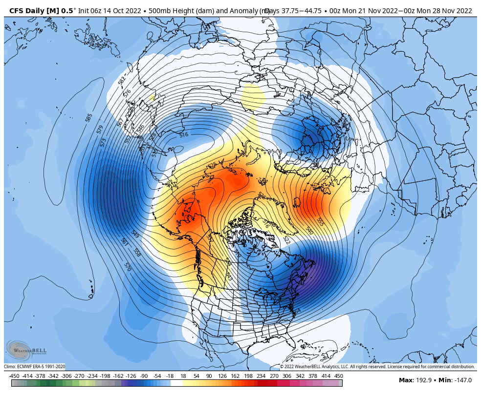
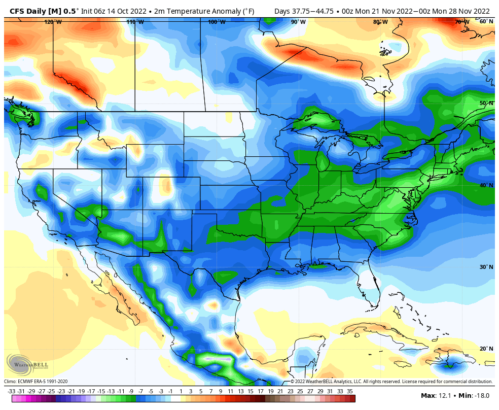
It'll change 100x between now and then LOL but fun to look at at this range & wish LOL!
_________________
Mugs
AKA:King: Snow Weenie
Self Proclaimed
WINTER 2014-15 : 55.12" +.02 for 6 coatings (avg. 35")
WINTER 2015-16 Total - 29.8" (Avg 35")
WINTER 2016-17 : 39.5" so far

amugs- Advanced Forecaster - Mod

- Posts : 15145
Reputation : 213
Join date : 2013-01-07
Age : 54
Location : Hillsdale,NJ
 Re: Long Range Thread 25.0
I am not complaining about that lol I hope we all do better this winteramugs wrote:Well fast start to winter??
CFSv2 stays Tahnksgiving week going to be winterish.
It'll change 100x between now and then LOL but fun to look at at this range & wish LOL!
frank 638- Senior Enthusiast

- Posts : 2877
Reputation : 37
Join date : 2016-01-01
Age : 41
Location : bronx ny
 Re: Long Range Thread 25.0
And a transcript if you don't want to head in that direction:
Justin Hartnett, an Assistant Professor of Geography and Environmental Sustainability at SUNY Oneonta, explores the differences in snowstorms to the lee of Lake Ontario. His research focuses on snowstorms in the Great Lakes and Northeast United States and how different snowstorms contribute to seasonal snowfall totals. He’s currently researching how variations in different snowstorms will impact future snowfall totals throughout the region. He teaches courses in physical geography, climatology, environmental science, and geospatial analysis.
The Great Lakes basin is one of the snowiest regions in North America. Snow has become an integral part of its natural and human environments. But as the global climate warms, how will snow respond?
To answer this question, we must first understand where the snow comes from. My research uses satellite imagery, radar, reanalysis, and ground observations to reconstruct snowstorms downwind of Lake Ontario. Over the past 30 years, there have been eleven different storm types to produce snow east of Lake Ontario including lake-effect snowstorms, Nor’easters, and clippers.
Why does this matter? Because snowfall contributions from these eleven storm types can exhibit considerable variability even within the Lake Ontario basin. Therefore, I needed to determine the relative contribution of each storm type to seasonal snowfall totals throughout the basin. Although there is this notion that lake-effect dominates snowfall totals east of Lake Ontario, I found a clear spatial dimension that has been overlooked. While most of the study area was dominated by lake-effect, there were locations where Nor’easters and Rocky lows contributed more to seasonal snowfall totals. Regardless, snowfall contributions from all eleven storm types varied across the study area.
Understanding where a location’s snowfall is derived from will help improve seasonal snowfall predictions both in the near future and as the climate changes. It is projected that the eleven storm types will respond differently to a warming climate. Therefore, even within a small region, two separate locations may see their snow trend in opposite directions.
kalleg- Posts : 158
Reputation : 2
Join date : 2013-01-15
Location : New Hope, PA
weatherwatchermom and JT33 like this post
 Re: Long Range Thread 25.0
Link to the write up and is excellently done:
https://arcfieldweather.com/blog/2022/10/12/2022-2023-winter-outlook-by-arcfield-weather
_________________
Mugs
AKA:King: Snow Weenie
Self Proclaimed
WINTER 2014-15 : 55.12" +.02 for 6 coatings (avg. 35")
WINTER 2015-16 Total - 29.8" (Avg 35")
WINTER 2016-17 : 39.5" so far

amugs- Advanced Forecaster - Mod

- Posts : 15145
Reputation : 213
Join date : 2013-01-07
Age : 54
Location : Hillsdale,NJ
weatherwatchermom likes this post
 Re: Long Range Thread 25.0
_________________
Mugs
AKA:King: Snow Weenie
Self Proclaimed
WINTER 2014-15 : 55.12" +.02 for 6 coatings (avg. 35")
WINTER 2015-16 Total - 29.8" (Avg 35")
WINTER 2016-17 : 39.5" so far

amugs- Advanced Forecaster - Mod

- Posts : 15145
Reputation : 213
Join date : 2013-01-07
Age : 54
Location : Hillsdale,NJ
 Re: Long Range Thread 25.0
_________________
Mugs
AKA:King: Snow Weenie
Self Proclaimed
WINTER 2014-15 : 55.12" +.02 for 6 coatings (avg. 35")
WINTER 2015-16 Total - 29.8" (Avg 35")
WINTER 2016-17 : 39.5" so far

amugs- Advanced Forecaster - Mod

- Posts : 15145
Reputation : 213
Join date : 2013-01-07
Age : 54
Location : Hillsdale,NJ
 Re: Long Range Thread 25.0
https://www.accuweather.com/en/winter-weather/accuweather-has-the-scoop-on-the-us-winter-forecast/1264945

docstox12- Wx Statistician Guru

- Posts : 8610
Reputation : 222
Join date : 2013-01-07
Age : 74
Location : Monroe NY
 Re: Long Range Thread 25.0
_________________
Mugs
AKA:King: Snow Weenie
Self Proclaimed
WINTER 2014-15 : 55.12" +.02 for 6 coatings (avg. 35")
WINTER 2015-16 Total - 29.8" (Avg 35")
WINTER 2016-17 : 39.5" so far

amugs- Advanced Forecaster - Mod

- Posts : 15145
Reputation : 213
Join date : 2013-01-07
Age : 54
Location : Hillsdale,NJ
 Re: Long Range Thread 25.0
_________________
Mugs
AKA:King: Snow Weenie
Self Proclaimed
WINTER 2014-15 : 55.12" +.02 for 6 coatings (avg. 35")
WINTER 2015-16 Total - 29.8" (Avg 35")
WINTER 2016-17 : 39.5" so far

amugs- Advanced Forecaster - Mod

- Posts : 15145
Reputation : 213
Join date : 2013-01-07
Age : 54
Location : Hillsdale,NJ
 Re: Long Range Thread 25.0
Signs of legit -NAO/+PNA pattern later in November courtesy of recent tropical forcing developments similar to past years 2020,2010 timing wise. A Nino like injection of +AAM and westeries in to tropics should force the atmosfére to compensate and weaken usual mid lat westeries. pic.twitter.com/xIDm5b2IBn
— Julius Subovic (@JuliusSubovic) October 24, 2022
Means winter maybe getting off to a fast start after this warm spell of Indian Summer
_________________
Mugs
AKA:King: Snow Weenie
Self Proclaimed
WINTER 2014-15 : 55.12" +.02 for 6 coatings (avg. 35")
WINTER 2015-16 Total - 29.8" (Avg 35")
WINTER 2016-17 : 39.5" so far

amugs- Advanced Forecaster - Mod

- Posts : 15145
Reputation : 213
Join date : 2013-01-07
Age : 54
Location : Hillsdale,NJ
 Re: Long Range Thread 25.0
I had given an update at one point in August/early September about the impressive consistency of the current La Nina.
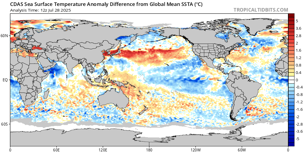
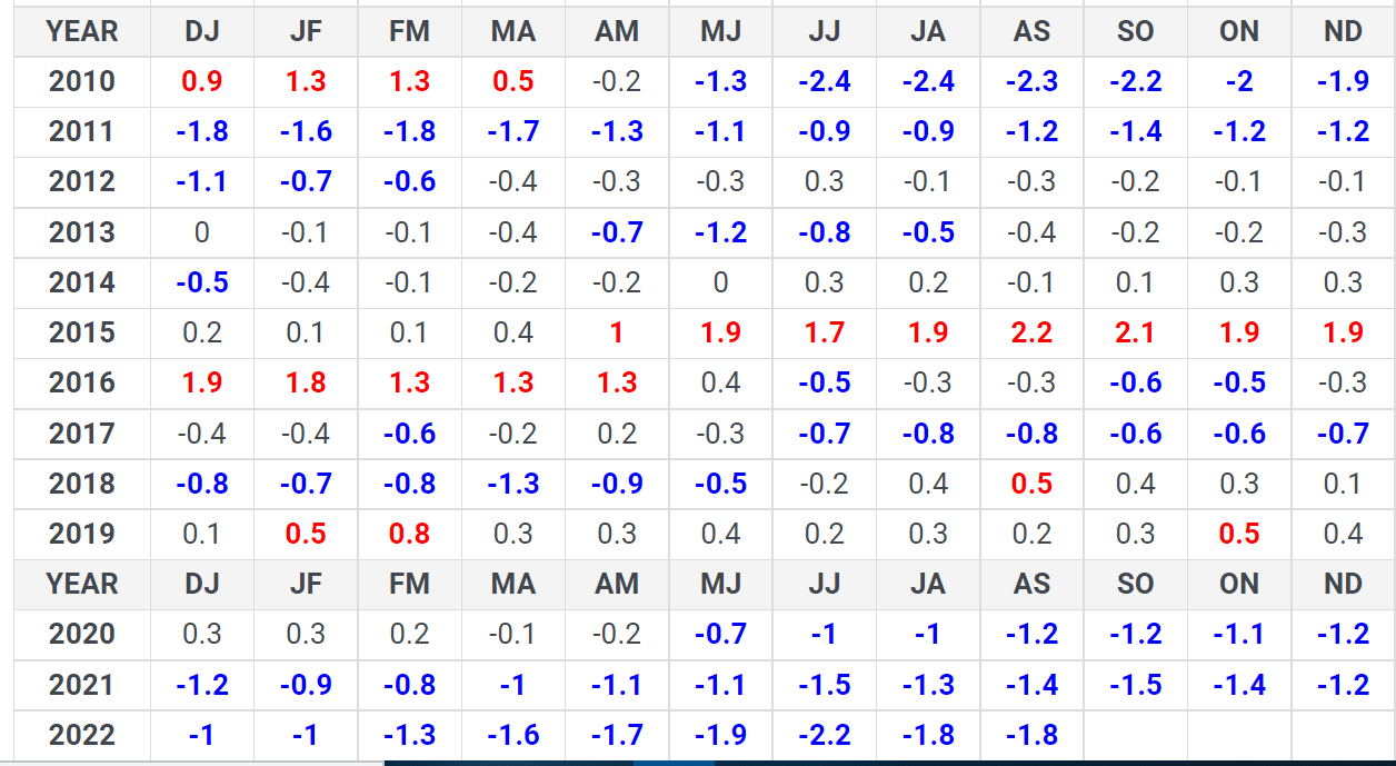
The MEI values since 2010 prove we have not seen moderate/strong La Nina status in the ENSO region for three consecutive winters. On October 13th, in their latest ENSO update, NOAA wrote "there is a 75% chance that La Nina will persist across the tropical pacific for the third winter in a row."
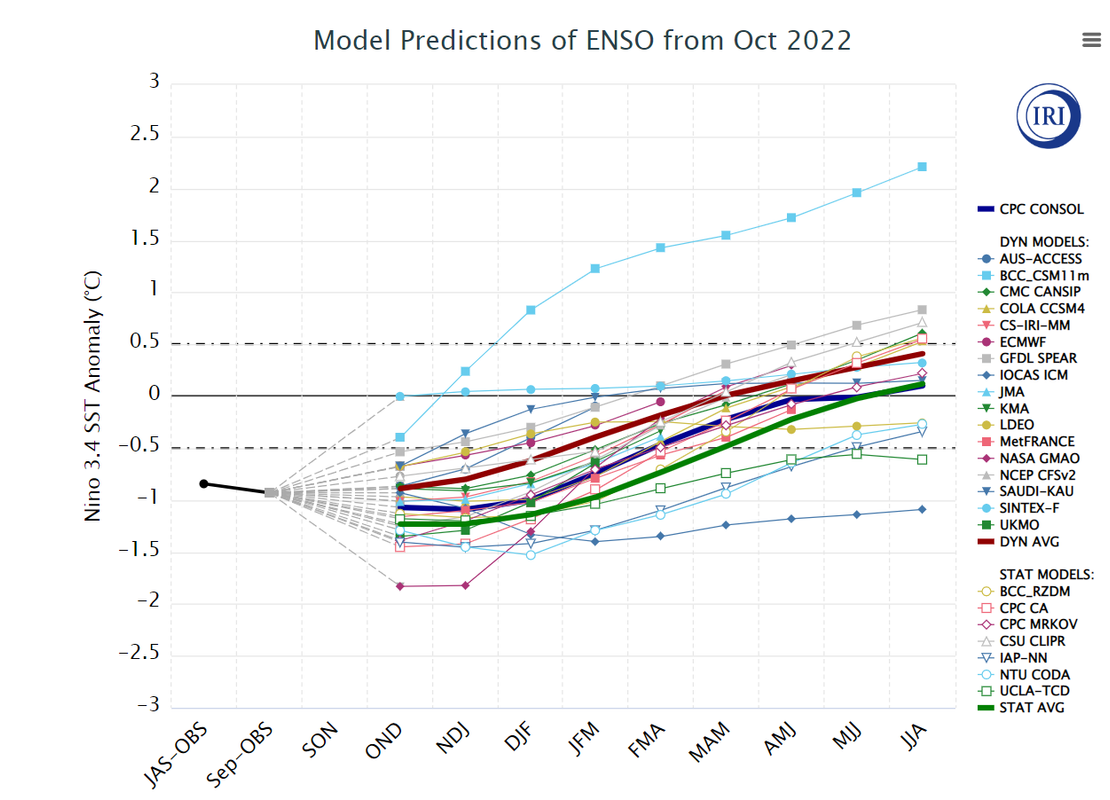
The statistical models show La Nina fading by late winter into spring. There's a good chance we'll be out of this cycle by Summer 2023. What does a moderately strong Nina mean for Winter '22-'23? Hard to say for sure, as there are a bunch of other factors to consider.
_________________
_______________________________________________________________________________________________________
CLICK HERE to view NJ Strong Snowstorm Classifications
 Re: Long Range Thread 25.0
_________________
Mugs
AKA:King: Snow Weenie
Self Proclaimed
WINTER 2014-15 : 55.12" +.02 for 6 coatings (avg. 35")
WINTER 2015-16 Total - 29.8" (Avg 35")
WINTER 2016-17 : 39.5" so far

amugs- Advanced Forecaster - Mod

- Posts : 15145
Reputation : 213
Join date : 2013-01-07
Age : 54
Location : Hillsdale,NJ
 Re: Long Range Thread 25.0
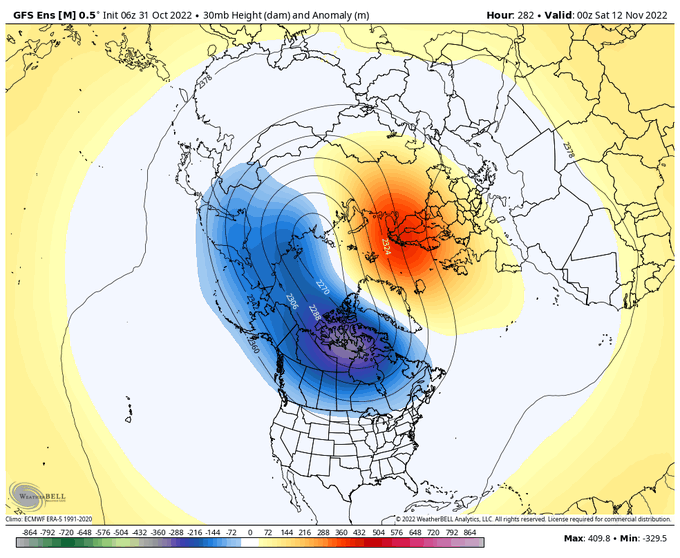
BAMWX
@bamwxcom
(1/3) The stretching the #PolarVortex could certainly make things interesting late November if Greenland blocking signals can verify. Would provide a nice pathway for cold air to dive into CONUS.

algae888- Advanced Forecaster

- Posts : 5311
Reputation : 46
Join date : 2013-02-05
Age : 62
Location : mt. vernon, new york

algae888- Advanced Forecaster

- Posts : 5311
Reputation : 46
Join date : 2013-02-05
Age : 62
Location : mt. vernon, new york
sroc4, amugs and kalleg like this post
 Re: Long Range Thread 25.0
_________________
Mugs
AKA:King: Snow Weenie
Self Proclaimed
WINTER 2014-15 : 55.12" +.02 for 6 coatings (avg. 35")
WINTER 2015-16 Total - 29.8" (Avg 35")
WINTER 2016-17 : 39.5" so far

amugs- Advanced Forecaster - Mod

- Posts : 15145
Reputation : 213
Join date : 2013-01-07
Age : 54
Location : Hillsdale,NJ
 Re: Long Range Thread 25.0
The perfect pattern is right around that corner. We'll see.

_________________
"In weather and in life, there's no winning and losing; there's only winning and learning."
WINTER 2012/2013 TOTALS 43.65"WINTER 2017/2018 TOTALS 62.85" WINTER 2022/2023 TOTALS 4.9"
WINTER 2013/2014 TOTALS 64.85"WINTER 2018/2019 TOTALS 14.25" WINTER 2023/2024 TOTALS 13.1"
WINTER 2014/2015 TOTALS 71.20"WINTER 2019/2020 TOTALS 6.35" WINTER 2024/2025 TOTALS 0.00
WINTER 2015/2016 TOTALS 35.00"WINTER 2020/2021 TOTALS 37.75"
WINTER 2016/2017 TOTALS 42.25"WINTER 2021/2022 TOTALS 31.65"

sroc4- Admin

- Posts : 8458
Reputation : 302
Join date : 2013-01-07
Location : Wading River, LI
kalleg likes this post
 Re: Long Range Thread 25.0

docstox12- Wx Statistician Guru

- Posts : 8610
Reputation : 222
Join date : 2013-01-07
Age : 74
Location : Monroe NY
 Re: Long Range Thread 25.0
docstox12 wrote:Not liking this extended warm period at all.Hope we get the shift into the colder air mid month as indicators lean to.Day after day I see winter storm warnings and watches in Colorado, Wyoming, Utah Idaho and Montana.Hope thats not a hint of a long range pattern.
I must say, I have been loving the warmer temps. It's been nice for cleaning up the yard and leaves in short sleeves. It can get cold when I'm done in a few weeks!
_________________
Janet
Snowfall winter of 2023-2024 17.5"
Snowfall winter of 2022-2023 6.0"
Snowfall winter of 2021-2022 17.6" 1" sleet 2/25/22
Snowfall winter of 2020-2021 51.1"
Snowfall winter of 2019-2020 8.5"
Snowfall winter of 2018-2019 25.1"
Snowfall winter of 2017-2018 51.9"
Snowfall winter of 2016-2017 45.6"
Snowfall winter of 2015-2016 29.5"
Snowfall winter of 2014-2015 50.55"
Snowfall winter of 2013-2014 66.5"
Dunnzoo- Senior Enthusiast - Mod

- Posts : 4934
Reputation : 68
Join date : 2013-01-11
Age : 62
Location : Westwood, NJ
 Re: Long Range Thread 25.0
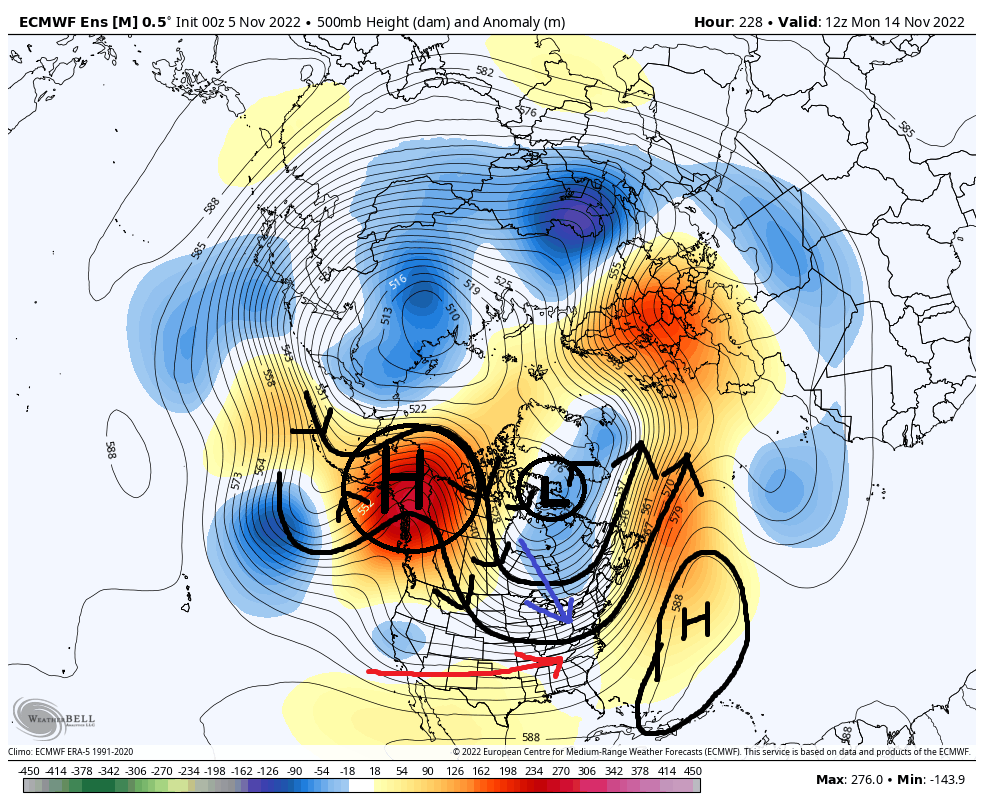
You can see on the graph above the EPO goes strongly negative in only a couple of days and seems to remain there for at least the next 3weeks. What this means is that an upper level ridge is building into the Alaska region and surrounding area, which will send the northern branch of jet stream on a detour into the arctic region which will begin to push the cold arctic and polar air masses south. Initially it will discharge an arctic blast south into the western third of North America, because the Western Atlantic Ridge(WAR) is currently flexing its muscles pumping the deep subtropical warm air mass into the eastern half-two thirds of NA.
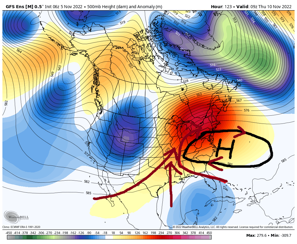
BUT the persistent -EPO is going to continue to pour the polar and arctic air southward, and like a bucket of water on a fire it should eventually put out the warmth of the WAR. The cold is going to start to push on that WAR and begin to bleed eastward with time such that by mid month it appears that North America as a whole will be in a cold/cooler than normal temperature regime. Both the EPS and GEFS are in fairly good agreement on this.
There is definitely support to this outcome as indicated by the MJO forecast, AND as Mugsy mentioned, the SOI index which has crashed for the past 3-4days or so, which when in a La Nina base state, when you get a 5-7days SOI crash it tends to be the "cattle prod" to the atmosphere(phrase coined by JB) such that changes are amis.
I personally cont to hold onto a few grains of skepticism. Will this be sustained? Will it be temporary? I'll remain objective and say let's get into the pattern change first before we look beyond mid month. BUT I will say this sustained or not our members who reside N&W, off the coastal plain have great chance at measurable snow by mid month. And coastal plain has a chance to see flakes as well if this pattern change is for real. We'll see. Enjoy the 70's this weekend because it looks like we wont see them again any time soon.
WE TRACK!!!

_________________
"In weather and in life, there's no winning and losing; there's only winning and learning."
WINTER 2012/2013 TOTALS 43.65"WINTER 2017/2018 TOTALS 62.85" WINTER 2022/2023 TOTALS 4.9"
WINTER 2013/2014 TOTALS 64.85"WINTER 2018/2019 TOTALS 14.25" WINTER 2023/2024 TOTALS 13.1"
WINTER 2014/2015 TOTALS 71.20"WINTER 2019/2020 TOTALS 6.35" WINTER 2024/2025 TOTALS 0.00
WINTER 2015/2016 TOTALS 35.00"WINTER 2020/2021 TOTALS 37.75"
WINTER 2016/2017 TOTALS 42.25"WINTER 2021/2022 TOTALS 31.65"

sroc4- Admin

- Posts : 8458
Reputation : 302
Join date : 2013-01-07
Location : Wading River, LI
kalleg, weatherwatchermom and Irish like this post
 Re: Long Range Thread 25.0
Hey Janet, better not say you are enjoying these warm temps too much, they will bring you in for an intervention for those warmacist statements,LOL.

docstox12- Wx Statistician Guru

- Posts : 8610
Reputation : 222
Join date : 2013-01-07
Age : 74
Location : Monroe NY
Dunnzoo and Sparky Sparticles like this post
 Re: Long Range Thread 25.0
Here’s a composite of DJF temperatures over the US in winters following a November in which a sub-940mb low developed in the North Atlantic. #wxtwitter https://t.co/sLxClLpFmY pic.twitter.com/PtzuKxvd6K
— Mark Margavage (@MeteoMark) November 5, 2022
_________________
Mugs
AKA:King: Snow Weenie
Self Proclaimed
WINTER 2014-15 : 55.12" +.02 for 6 coatings (avg. 35")
WINTER 2015-16 Total - 29.8" (Avg 35")
WINTER 2016-17 : 39.5" so far

amugs- Advanced Forecaster - Mod

- Posts : 15145
Reputation : 213
Join date : 2013-01-07
Age : 54
Location : Hillsdale,NJ
 Re: Long Range Thread 25.0
_________________
Mugs
AKA:King: Snow Weenie
Self Proclaimed
WINTER 2014-15 : 55.12" +.02 for 6 coatings (avg. 35")
WINTER 2015-16 Total - 29.8" (Avg 35")
WINTER 2016-17 : 39.5" so far

amugs- Advanced Forecaster - Mod

- Posts : 15145
Reputation : 213
Join date : 2013-01-07
Age : 54
Location : Hillsdale,NJ
Page 1 of 40 • 1, 2, 3 ... 20 ... 40 

 Home
Home