Long Range Thread 25.0
+42
toople
Coachgriff
Carvin
Scullybutcher
Wheezer
lglickman1
dolphins222
Grselig
Zhukov1945
aiannone
CPcantmeasuresnow
jimv45
JT33
TheAresian
Radz
brownie
SENJsnowman
billg315
hyde345
SoulSingMG
Math23x7
phil155
snowbunny
mmanisca
Abba701
MattyICE
GreyBeard
nutleyblizzard
heehaw453
weatherwatchermom
HectorO
jmanley32
Irish
dkodgis
Dunnzoo
sroc4
algae888
Frank_Wx
kalleg
frank 638
docstox12
amugs
46 posters
Page 9 of 40
Page 9 of 40 •  1 ... 6 ... 8, 9, 10 ... 24 ... 40
 Re: Long Range Thread 25.0
The 12/9 0Z 12 km NAM for Sunday gives a couple of inches of snow for me here in Albany with higher amounts to my south and west in the Catskills.
Keep in mind that with the strong -PNA, systems that come this way have a better chance of giving snow to the interior northeast than to the I-95 corridor. Also keep in mind that there is a cutoff where the precipitation will fizzle out as indicated by hr 84, so I would like to see if the location of the snow band holds.
Though in my case, given the pattern, I would these amounts shown and run with them.

Math23x7- Wx Statistician Guru

- Posts : 2382
Join date : 2013-01-08
 Re: Long Range Thread 25.0
If I can see some flakes I would be pleased with that for this time of year and with the mild temps we have had.
jmanley32- Senior Enthusiast

- Posts : 20635
Join date : 2013-12-12
 Re: Long Range Thread 25.0
Mugsy, excellent post illustrating what blocking is and it's effects.As they say, a picture is worth a thousand words.It's very clear to me now what the concept is.Amazing what it does to a cutter, the storm track we snow lovers hate.

docstox12- Wx Statistician Guru

- Posts : 8589
Reputation : 222
Join date : 2013-01-07
Age : 73
Location : Monroe NY
 Re: Long Range Thread 25.0
Math23x7 wrote:The 12/9 0Z 12 km NAM for Sunday gives a couple of inches of snow for me here in Albany with higher amounts to my south and west in the Catskills.
Keep in mind that with the strong -PNA, systems that come this way have a better chance of giving snow to the interior northeast than to the I-95 corridor. Also keep in mind that there is a cutoff where the precipitation will fizzle out as indicated by hr 84, so I would like to see if the location of the snow band holds.
Though in my case, given the pattern, I would these amounts shown and run with them.
Looking more and more today that I will get here in the LHV 1-3 according to Accuweather or 1 1/2 to 2 1/2 according to NWS.Would be a nice opening act for the snow season.It's still Fall and snow before winter starts is not too common.Think Damian has the best chance to jackpot on this one.

docstox12- Wx Statistician Guru

- Posts : 8589
Reputation : 222
Join date : 2013-01-07
Age : 73
Location : Monroe NY
SENJsnowman likes this post
 Re: Long Range Thread 25.0
Sounds like a good call IMO 1-2" for LHV and Catskills/NW NJ/NEPA may get 3-4" due to elevation. The upper level low trajectory is not ideal and it's not well organized. Below rt 80 there will be white rain right down to rt 78 with possible coatings on colder surfaces. We take...docstox12 wrote:Math23x7 wrote:The 12/9 0Z 12 km NAM for Sunday gives a couple of inches of snow for me here in Albany with higher amounts to my south and west in the Catskills.
Keep in mind that with the strong -PNA, systems that come this way have a better chance of giving snow to the interior northeast than to the I-95 corridor. Also keep in mind that there is a cutoff where the precipitation will fizzle out as indicated by hr 84, so I would like to see if the location of the snow band holds.
Though in my case, given the pattern, I would these amounts shown and run with them.
Looking more and more today that I will get here in the LHV 1-3 according to Accuweather or 1 1/2 to 2 1/2 according to NWS.Would be a nice opening act for the snow season.It's still Fall and snow before winter starts is not too common.Think Damian has the best chance to jackpot on this one.
heehaw453- Advanced Forecaster

- Posts : 3908
Reputation : 86
Join date : 2014-01-20
Location : Bedminster Township, PA Elevation 600' ASL
 Re: Long Range Thread 25.0
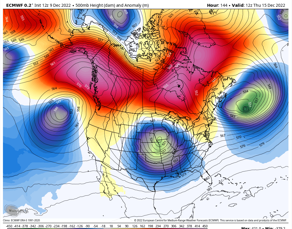
GFS pretty aggressive for next Friday 12/16ish. Just looking at the h5 on the mean it has some of the hallmarks of what you'd want to see. Vigorous ULL starting to dive, a very nice look in Canada/Alaska forcing storms off the EC as opposed to through the Great Lakes. 50/50 low to help plug up the Atlantic flow. But the ridge is immature on the mean and that's going to be needed to dig the ULL and force it under the area as well as create a strong storm. If that ridge starts to dip around Montana/Idaho through the Rockies, then big dog potential as shown on the GFS (second picture), but if it breaks down due to west coast trough not allowing the PNA to flex then much less interesting. As we say PNA doesn't need to be high in terms of a number it just needs to pop a bit at the right time. My guess is that the coastal plane has its best shot at seeing some snow from this to date, but unless/until other guidance comes in line with the ridge I think minor type of deal.


heehaw453- Advanced Forecaster

- Posts : 3908
Reputation : 86
Join date : 2014-01-20
Location : Bedminster Township, PA Elevation 600' ASL
SENJsnowman likes this post
 Re: Long Range Thread 25.0
heehaw453 wrote:GFS pretty aggressive for next Friday 12/16ish. Just looking at the h5 on the mean it has some of the hallmarks of what you'd want to see. Vigorous ULL starting to dive, a very nice look in Canada/Alaska forcing storms off the EC as opposed to through the Great Lakes. 50/50 low to help plug up the Atlantic flow. But the ridge is immature on the mean and that's going to be needed to dig the ULL and force it under the area as well as create a strong storm. If that ridge starts to dip around Montana/Idaho through the Rockies, then big dog potential as shown on the GFS (second picture), but if it breaks down due to west coast trough not allowing the PNA to flex then much less interesting. As we say PNA doesn't need to be high in terms of a number it just needs to pop a bit at the right time. My guess is that the coastal plane has its best shot at seeing some snow from this to date, but unless/until other guidance comes in line with the ridge I think minor type of deal.
Agreed. It’s not our slam dunk, PNA ridge spike Classic Miller A look at all. Much more fickle with confluence and CAD and redevelopment cyclogenesis etc. Many more factors to give us anxiety while we track, but that’s what it’s about. All that said - we can still find ways to score to the coast here and I’d be rather surprised if we didn’t by Christmas.
MattyICE- Advanced Forecaster

- Posts : 249
Reputation : 6
Join date : 2017-11-10
Age : 39
Location : Clifton, NJ (Eastern Passaic County)
heehaw453 likes this post
 Re: Long Range Thread 25.0
Looks like the GFS lost that Friday-Saturday storm altogether on the 12z run. Of course, this would be the timeframe where the models would lose a storm only to find it again five days out.

billg315- Advanced Forecaster - Mod

- Posts : 4531
Reputation : 185
Join date : 2015-01-24
Age : 50
Location : Flemington, NJ
 Re: Long Range Thread 25.0
Still watching…expected Stratospheric Warming illustrated by this map has materialized and resulted in the weakest PV at 100hPa on record. December is far from over and Poleward Heat Flux is now forecast to be +2 std deviations above normal. More interesting disruptions to come. https://t.co/5YfNJkHCCG pic.twitter.com/N5uu1WTvCt
— Mark Margavage (@MeteoMark) December 9, 2022
_________________
Mugs
AKA:King: Snow Weenie
Self Proclaimed
WINTER 2014-15 : 55.12" +.02 for 6 coatings (avg. 35")
WINTER 2015-16 Total - 29.8" (Avg 35")
WINTER 2016-17 : 39.5" so far

amugs- Advanced Forecaster - Mod

- Posts : 15130
Reputation : 213
Join date : 2013-01-07
Age : 54
Location : Hillsdale,NJ
 Re: Long Range Thread 25.0
Hi Bill. GFS 12z didn't lose it it's more the ridge popped too far east more in upper plains and the ULL didn't get a chance to amplify so it pushed out to sea. The ridge pop is going to be pot luck IMO. But what's encouraging is the GFS is showing a ridge potential and IMO has been better on the PAC side for modelling verification. So we'll see.billg315 wrote:Looks like the GFS lost that Friday-Saturday storm altogether on the 12z run. Of course, this would be the timeframe where the models would lose a storm only to find it again five days out.

heehaw453- Advanced Forecaster

- Posts : 3908
Reputation : 86
Join date : 2014-01-20
Location : Bedminster Township, PA Elevation 600' ASL
 Re: Long Range Thread 25.0
billg315 wrote:Looks like the GFS lost that Friday-Saturday storm altogether on the 12z run. Of course, this would be the timeframe where the models would lose a storm only to find it again five days out.
Yeah this particular run demonstrates ANOTHER way we can avoid cashing in - TOO much blocking leading to a southern slider or just a real sheared out trough.
MattyICE- Advanced Forecaster

- Posts : 249
Reputation : 6
Join date : 2017-11-10
Age : 39
Location : Clifton, NJ (Eastern Passaic County)
 Re: Long Range Thread 25.0
billg315 wrote:Looks like the GFS lost that Friday-Saturday storm altogether on the 12z run. Of course, this would be the timeframe where the models would lose a storm only to find it again five days out.
CMC/REM still has it in today's midday run. As a matter of fact, this was the strongest CMC run yet for next weekend: a foot plus for everyone N of I-78!
SENJsnowman- Senior Enthusiast

- Posts : 1196
Reputation : 61
Join date : 2017-01-06
Age : 51
Location : Long Branch, NJ
heehaw453 likes this post
heehaw453- Advanced Forecaster

- Posts : 3908
Reputation : 86
Join date : 2014-01-20
Location : Bedminster Township, PA Elevation 600' ASL
 Re: Long Range Thread 25.0
This is what I've been noticing. The PNA relaxes on the modelling and this gives a window. The orientation of the ridge and the ULL strength all are factors in play. But you see synoptically blocking, 50/50 low, vigorous ULL, PNA starting to relax and even pop. So this all you can ask for at D6. Just need to see how this looks on Monday to see if these pieces are lining up. Players are on the table though...


heehaw453- Advanced Forecaster

- Posts : 3908
Reputation : 86
Join date : 2014-01-20
Location : Bedminster Township, PA Elevation 600' ASL
SENJsnowman likes this post
 Re: Long Range Thread 25.0
Guys and gals, the GFS upgrade has been suffering major issues with its tropical heat and moisture algorithm calcs thus causing havoc amongst it s pattern recognition details as was stated by Dr. Alicia Bently and even the EMC platform group that worked on the upgrade. This is for anything outside of 6 days from what many who are investigating are saying. So analyze this model all you want in the long range but understand this and its outcome effects. The smallest details as we see can have massive downstream and upstream effects. The GEFS are different and did not receive an upgrade.
This euro map Haw posted above screams potential, high end at me.

This euro map Haw posted above screams potential, high end at me.

_________________
Mugs
AKA:King: Snow Weenie
Self Proclaimed
WINTER 2014-15 : 55.12" +.02 for 6 coatings (avg. 35")
WINTER 2015-16 Total - 29.8" (Avg 35")
WINTER 2016-17 : 39.5" so far

amugs- Advanced Forecaster - Mod

- Posts : 15130
Reputation : 213
Join date : 2013-01-07
Age : 54
Location : Hillsdale,NJ
hyde345 and MattyICE like this post
 Re: Long Range Thread 25.0
amugs wrote:Guys and gals, the GFS upgrade has been suffering major issues with its tropical heat and moisture algorithm calcs thus causing havoc amongst it s pattern recognition details as was stated by Dr. Alicia Bently and even the EMC platform group that worked on the upgrade. This is for anything outside of 6 days from what many who are investigating are saying. So analyze this model all you want in the long range but understand this and its outcome effects. The smallest details as we see can have massive downstream and upstream effects. The GEFS are different and did not receive an upgrade.
This euro map Haw posted above screams potential, high end at me.
Just another example of a model performing worse after a so called upgrade. I have never trusted the GFS beyond 72 hours and certainly won't now.

hyde345- Pro Enthusiast

- Posts : 1082
Reputation : 48
Join date : 2013-01-08
Location : Hyde Park, NY
heehaw453- Advanced Forecaster

- Posts : 3908
Reputation : 86
Join date : 2014-01-20
Location : Bedminster Township, PA Elevation 600' ASL
sroc4 and Irish like this post
 Re: Long Range Thread 25.0
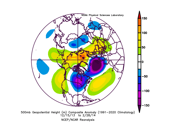
I was about to post the PNA outlook to say that the trend was encouraging today in that regard. Also, there are indications that the EPO (while temporarily positive) may become super negative later this month. If, going forward, we have a slightly PNA and a super -EPO, I would be fine with that, even if the -AO/-NAO couplet breaks down. The 2013-14 and 2014-15 winters actually had just that, not so great Atlantic-based teleconnections, but great Pacific based teleconnections.
I would like to see this trend continue, however, before I get really excited about it. But for me here in Albany, the potential for a couple of inches of snow on Sunday, combined with the outside chance of something brewing for late next week, certainly have my interest.
Math23x7- Wx Statistician Guru

- Posts : 2382
Reputation : 68
Join date : 2013-01-08
 Re: Long Range Thread 25.0
2014-15 winter more so. 2013-14 was more neutral NAM, but your point is valid. The cold was able to slip into the EC via the EPO/PNA and the amplification provided the storms...Math23x7 wrote:
I was about to post the PNA outlook to say that the trend was encouraging today in that regard. Also, there are indications that the EPO (while temporarily positive) may become super negative later this month. If, going forward, we have a slightly PNA and a super -EPO, I would be fine with that, even if the -AO/-NAO couplet breaks down. The 2013-14 and 2014-15 winters actually had just that, not so great Atlantic-based teleconnections, but great Pacific based teleconnections.
I would like to see this trend continue, however, before I get really excited about it. But for me here in Albany, the potential for a couple of inches of snow on Sunday, combined with the outside chance of something brewing for late next week, certainly have my interest.


heehaw453- Advanced Forecaster

- Posts : 3908
Reputation : 86
Join date : 2014-01-20
Location : Bedminster Township, PA Elevation 600' ASL
 Re: Long Range Thread 25.0
18z GFS no better than the 12z for Fri-Sat. Very flat look. Well, have to place our hopes in our Canadian and European friends until the GFS jumps back on board. 

billg315- Advanced Forecaster - Mod

- Posts : 4531
Reputation : 185
Join date : 2015-01-24
Age : 50
Location : Flemington, NJ
 Re: Long Range Thread 25.0
Nooooooooooooooooooooooooooooooooooooooooooooooooooooooooooooooooooooooooooooooooooooooooooooo

dkodgis- Senior Enthusiast

- Posts : 2667
Reputation : 98
Join date : 2013-12-29
 Re: Long Range Thread 25.0
billg315 wrote:18z GFS no better than the 12z for Fri-Sat. Very flat look. Well, have to place our hopes in our Canadian and European friends until the GFS jumps back on board.
It just makes no sense being so flat and the low being weak and so far south. The Euro and CMC are are at least plausible solutions. I would be shocked if GFS is correct.

hyde345- Pro Enthusiast

- Posts : 1082
Reputation : 48
Join date : 2013-01-08
Location : Hyde Park, NY
 Re: Long Range Thread 25.0
hyde345 wrote:billg315 wrote:18z GFS no better than the 12z for Fri-Sat. Very flat look. Well, have to place our hopes in our Canadian and European friends until the GFS jumps back on board.
It just makes no sense being so flat and the low being weak and so far south. The Euro and CMC are are at least plausible solutions. I would be shocked if GFS is correct.
Yeah, I’m not placing a lot of stock in these recent runs of the GFS right now. I think something is brewing for end-o-week. I’m not sure what exactly, but something more than what the gfs has been spitting out.

billg315- Advanced Forecaster - Mod

- Posts : 4531
Reputation : 185
Join date : 2015-01-24
Age : 50
Location : Flemington, NJ
sroc4 and hyde345 like this post
 Re: Long Range Thread 25.0
_________________
Mugs
AKA:King: Snow Weenie
Self Proclaimed
WINTER 2014-15 : 55.12" +.02 for 6 coatings (avg. 35")
WINTER 2015-16 Total - 29.8" (Avg 35")
WINTER 2016-17 : 39.5" so far

amugs- Advanced Forecaster - Mod

- Posts : 15130
Reputation : 213
Join date : 2013-01-07
Age : 54
Location : Hillsdale,NJ

Irish- Pro Enthusiast

- Posts : 788
Reputation : 19
Join date : 2019-01-16
Age : 46
Location : Old Bridge, NJ
 Re: Long Range Thread 25.0
_________________
Mugs
AKA:King: Snow Weenie
Self Proclaimed
WINTER 2014-15 : 55.12" +.02 for 6 coatings (avg. 35")
WINTER 2015-16 Total - 29.8" (Avg 35")
WINTER 2016-17 : 39.5" so far

amugs- Advanced Forecaster - Mod

- Posts : 15130
Reputation : 213
Join date : 2013-01-07
Age : 54
Location : Hillsdale,NJ
Irish likes this post
 Re: Long Range Thread 25.0
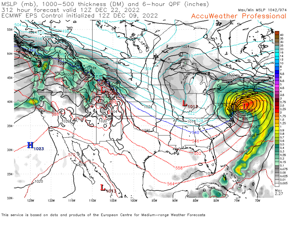
Hour 312 really? really? We all know better than to look at that. 20's in FL, I will bet that won't happen but of course i could be wrong lets check back in 9-11 days.amugs wrote:
It is such a deep Negative EPO it is off the charts, if it verifies it shatters records and drive absolutely
tremendous cold into the lower 48.
This map is mint for extreme cold and the entire country goes into the freezer with this look.
This by the Euro Control would be a heck of a storm.

jmanley32- Senior Enthusiast

- Posts : 20635
Reputation : 108
Join date : 2013-12-12
Age : 43
Location : Yonkers, NY
Page 9 of 40 •  1 ... 6 ... 8, 9, 10 ... 24 ... 40
Page 9 of 40
Permissions in this forum:
You cannot reply to topics in this forum|
|
|

 Home
Home


