Long Range Thread 25.0
+42
toople
Coachgriff
Carvin
Scullybutcher
Wheezer
lglickman1
dolphins222
Grselig
Zhukov1945
aiannone
CPcantmeasuresnow
jimv45
JT33
TheAresian
Radz
brownie
SENJsnowman
billg315
hyde345
SoulSingMG
Math23x7
phil155
snowbunny
mmanisca
Abba701
MattyICE
GreyBeard
nutleyblizzard
heehaw453
weatherwatchermom
HectorO
jmanley32
Irish
dkodgis
Dunnzoo
sroc4
algae888
Frank_Wx
kalleg
frank 638
docstox12
amugs
46 posters
Page 17 of 40
Page 17 of 40 •  1 ... 10 ... 16, 17, 18 ... 28 ... 40
 Re: Long Range Thread 25.0
MattyICE wrote:heehaw453 wrote:What will wind up happening is what usually happens Mother Nature will slip in a well timed short wave when the pattern looks to be unfavorable and we'll on the board with renewed energy.
Agree. I got too excited in long range potential when it looked good. For me, the lesson is to not get equally DOWN now that the long range looks crappy. Could the rest of the winter bust? I suppose but highly unlikely. I think we enjoy the holidays. Reset. Stay patient. Stop looking so far down the road, whatever it shows. If we can do that, I agree, we can get something modest in the short range to brighten things up.
I mean, isn't late Jan through March really when we get most of our snow anyway? Seems like quite a few seasons have been busts up until Feb...I hate operating via anecdote and couldn't statistically prove it, but I never really lose hope until we get into there and nothing on the horizon.
Zhukov1945- Posts : 138
Join date : 2018-03-21
amugs, kalleg, SENJsnowman and phil155 like this post
 Re: Long Range Thread 25.0
Zhukov1945 wrote:MattyICE wrote:heehaw453 wrote:What will wind up happening is what usually happens Mother Nature will slip in a well timed short wave when the pattern looks to be unfavorable and we'll on the board with renewed energy.
Agree. I got too excited in long range potential when it looked good. For me, the lesson is to not get equally DOWN now that the long range looks crappy. Could the rest of the winter bust? I suppose but highly unlikely. I think we enjoy the holidays. Reset. Stay patient. Stop looking so far down the road, whatever it shows. If we can do that, I agree, we can get something modest in the short range to brighten things up.
I mean, isn't late Jan through March really when we get most of our snow anyway? Seems like quite a few seasons have been busts up until Feb...I hate operating via anecdote and couldn't statistically prove it, but I never really lose hope until we get into there and nothing on the horizon.
Sure, especially in the last several years March has become on average a more “wintery” month than December in many locations - my point is more to not get too down if the long range looks unfavorable. Since long range favorability didn’t work out, I have little reason to believe unfavorable looks will either.
MattyICE- Advanced Forecaster

- Posts : 249
Join date : 2017-11-10
kalleg, SENJsnowman and Zhukov1945 like this post
 Re: Long Range Thread 25.0
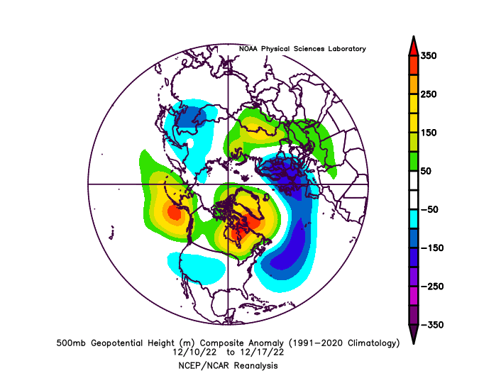
100%. The long range flips drastically. The ENSO state though does favor east coast ridging which is what we will see before this upcoming storm as the NAO ridge drops into the EC. That being said the pattern provided a window in December on which many on this board couldn't capitalize on. You can see what we have in the last week (bottom picture) isn't your typical La Nina (top picture). The pattern from last week (bottom picture) I've seen many an east coast snow storm from it. We won't cash in and that's bad luck and timing of the PNA not being more mature which would typically push the west coast ridge further east. Had the ridge been further east we'd be having a much different outcome.MattyICE wrote:Zhukov1945 wrote:MattyICE wrote:heehaw453 wrote:What will wind up happening is what usually happens Mother Nature will slip in a well timed short wave when the pattern looks to be unfavorable and we'll on the board with renewed energy.
Agree. I got too excited in long range potential when it looked good. For me, the lesson is to not get equally DOWN now that the long range looks crappy. Could the rest of the winter bust? I suppose but highly unlikely. I think we enjoy the holidays. Reset. Stay patient. Stop looking so far down the road, whatever it shows. If we can do that, I agree, we can get something modest in the short range to brighten things up.
I mean, isn't late Jan through March really when we get most of our snow anyway? Seems like quite a few seasons have been busts up until Feb...I hate operating via anecdote and couldn't statistically prove it, but I never really lose hope until we get into there and nothing on the horizon.
Sure, especially in the last several years March has become on average a more “wintery” month than December in many locations - my point is more to not get too down if the long range looks unfavorable. Since long range favorability didn’t work out, I have little reason to believe unfavorable looks will either.
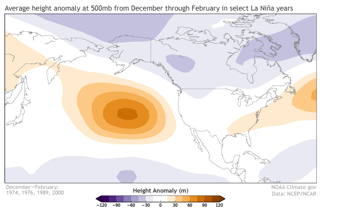
Last week 500mb
heehaw453- Advanced Forecaster

- Posts : 3908
Reputation : 86
Join date : 2014-01-20
Location : Bedminster Township, PA Elevation 600' ASL
 Re: Long Range Thread 25.0
Zhukov1945 wrote:MattyICE wrote:heehaw453 wrote:What will wind up happening is what usually happens Mother Nature will slip in a well timed short wave when the pattern looks to be unfavorable and we'll on the board with renewed energy.
Agree. I got too excited in long range potential when it looked good. For me, the lesson is to not get equally DOWN now that the long range looks crappy. Could the rest of the winter bust? I suppose but highly unlikely. I think we enjoy the holidays. Reset. Stay patient. Stop looking so far down the road, whatever it shows. If we can do that, I agree, we can get something modest in the short range to brighten things up.
I mean, isn't late Jan through March really when we get most of our snow anyway? Seems like quite a few seasons have been busts up until Feb...I hate operating via anecdote and couldn't statistically prove it, but I never really lose hope until we get into there and nothing on the horizon.
Traditionally, (at least in the more southern/eastern areas of this board i.e. Central NJ, Coastal areas, South Jersey), December is not terribly snowy and yes January through mid-March tends to be where we get our biggest storms. So as much as I like a good December snow, especially right before the holidays, I never really get that upset when it doesn't materialize because I've never lived in a part of this region where it is all that common.

billg315- Advanced Forecaster - Mod

- Posts : 4531
Reputation : 185
Join date : 2015-01-24
Age : 50
Location : Flemington, NJ
dkodgis, Zhukov1945 and phil155 like this post
heehaw453- Advanced Forecaster

- Posts : 3908
Reputation : 86
Join date : 2014-01-20
Location : Bedminster Township, PA Elevation 600' ASL
kalleg, dkodgis and Zhukov1945 like this post
 Re: Long Range Thread 25.0
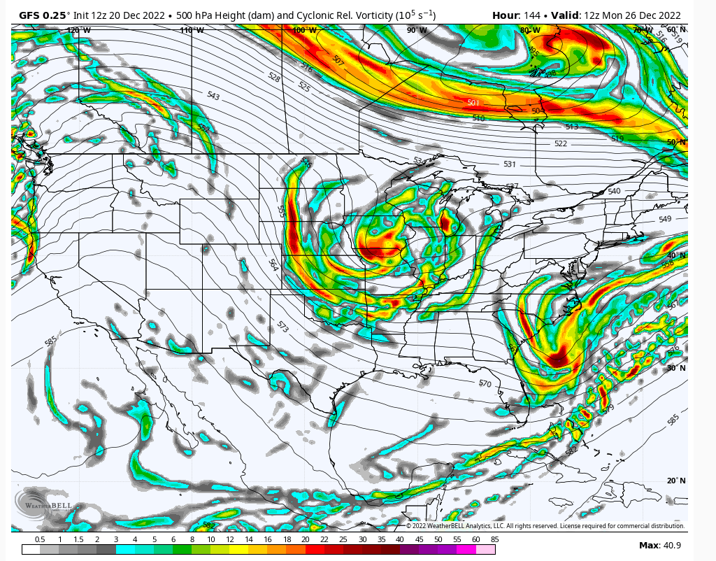
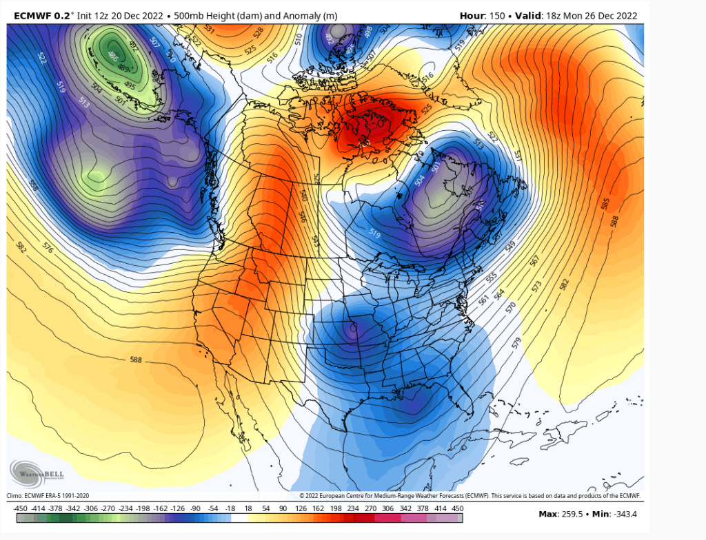
The question is whether or not the pattern being shown by the model is correct or will the trough again be placed further west or even too far east since that’s way off in time yet.

mmanisca- Pro Enthusiast

- Posts : 299
Reputation : 3
Join date : 2013-01-23
Age : 66
Location : Deer Park, Long Island
 Re: Long Range Thread 25.0
Agreed, it's too far out to know, but I think it will come down to s/w energy interactions between the trough and what's sliding down the ridge. Get that to interact at the right time and it will swing the trough neutral allowing for an impact. All you can ask for at this lead time is the ridge and an decent air mass... Beyond this the pattern is supposed to become hostile as the EP goes positive. But I'm not sure I buy the extent nor the duration of the warming just yet. Don't trust anything beyond 10 days.mmanisca wrote:
The question is whether or not the pattern being shown by the model is correct or will the trough again be placed further west or even too far east since that’s way off in time yet.
heehaw453- Advanced Forecaster

- Posts : 3908
Reputation : 86
Join date : 2014-01-20
Location : Bedminster Township, PA Elevation 600' ASL
mmanisca likes this post
heehaw453- Advanced Forecaster

- Posts : 3908
Reputation : 86
Join date : 2014-01-20
Location : Bedminster Township, PA Elevation 600' ASL
heehaw453- Advanced Forecaster

- Posts : 3908
Reputation : 86
Join date : 2014-01-20
Location : Bedminster Township, PA Elevation 600' ASL

SoulSingMG- Senior Enthusiast

- Posts : 2853
Reputation : 74
Join date : 2013-12-11
Location : Long Island City, NY
kalleg likes this post
MattyICE- Advanced Forecaster

- Posts : 249
Reputation : 6
Join date : 2017-11-10
Age : 39
Location : Clifton, NJ (Eastern Passaic County)
 Re: Long Range Thread 25.0
Yeah it's never simple is it
heehaw453- Advanced Forecaster

- Posts : 3908
Reputation : 86
Join date : 2014-01-20
Location : Bedminster Township, PA Elevation 600' ASL
 Re: Long Range Thread 25.0
heehaw453 wrote:Yeah it's never simple is itWe have to watch this in the next few days. The departing storm will push the block west based and hopefully it can pull NE into the 50/50 locale. The pac ridge is pushing hard on the system which would be my red flag right now. if the pac slows down then this has got good potential.
100%. But if those three can find a way to play nice? Boom.
MattyICE- Advanced Forecaster

- Posts : 249
Reputation : 6
Join date : 2017-11-10
Age : 39
Location : Clifton, NJ (Eastern Passaic County)
 Re: Long Range Thread 25.0
And currently TWC has nothing on the horizon for the 27th, so that could be a positive, since they originally had us getting blasted for this week's storm.

Irish- Pro Enthusiast

- Posts : 788
Reputation : 19
Join date : 2019-01-16
Age : 46
Location : Old Bridge, NJ
 Re: Long Range Thread 25.0
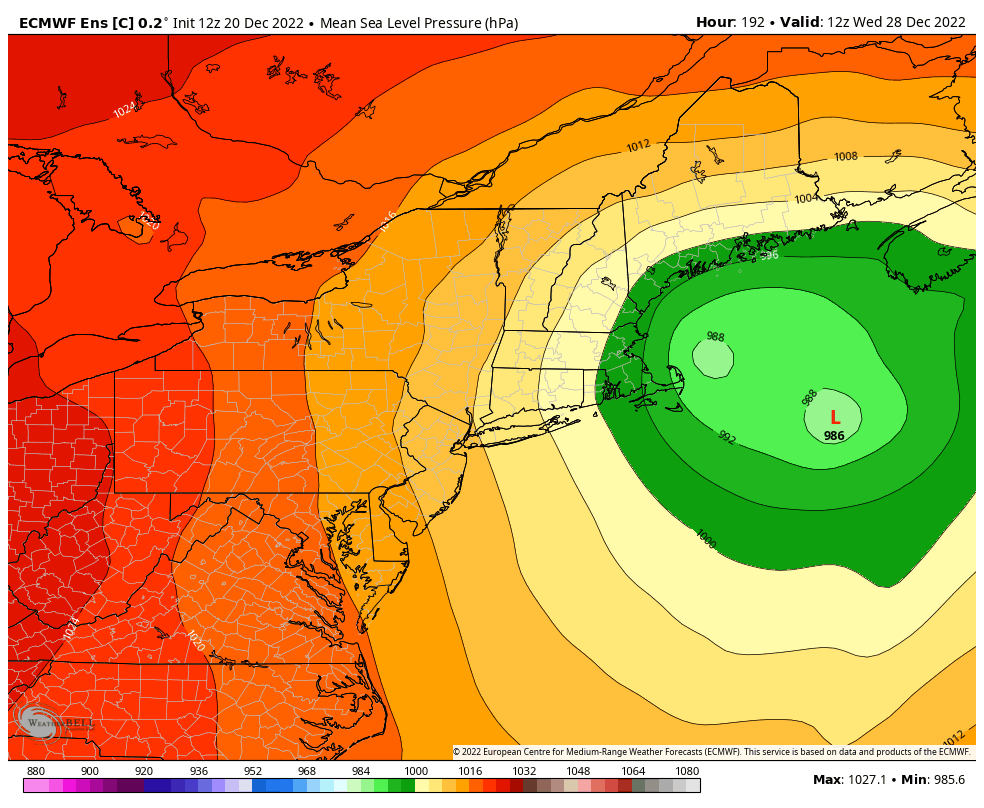
12z Euro at hr 198 snow map is beautiful for many, don't look. I happened to see on Bastardi's post. The models were show a 27th-28th storm several days back, to bring it back now is kind of a good sign, having it around for the entire span of every run seems to jinx it. Irish ya TWC jinx lol

jmanley32- Senior Enthusiast

- Posts : 20635
Reputation : 108
Join date : 2013-12-12
Age : 43
Location : Yonkers, NY
 Re: Long Range Thread 25.0
jmanley32 wrote:12z Euro at hr 198 snow map is beautiful for many, don't look. I happened to see on Bastardi's post. The models were show a 27th-28th storm several days back, to bring it back now is kind of a good sign, having it around for the entire span of every run seems to jinx it. Irish ya TWC jinx lol
I figured I'd try the reverse jinx. Last time I jumped in with TWC calling for a big snow storm this week and we're getting mostly rain. So, now if I say TWC is saying nothing, maybe we'll get dumped on!

Irish- Pro Enthusiast

- Posts : 788
Reputation : 19
Join date : 2019-01-16
Age : 46
Location : Old Bridge, NJ
 Re: Long Range Thread 25.0
heehaw453 wrote:Yeah it's never simple is itWe have to watch this in the next few days. The departing storm will push the block west based and hopefully it can pull NE into the 50/50 locale. The pac ridge is pushing hard on the system which would be my red flag right now. if the pac slows down then this has got good potential.
Bring it home fellas. You now have my ears perked
_________________
"In weather and in life, there's no winning and losing; there's only winning and learning."
WINTER 2012/2013 TOTALS 43.65"WINTER 2017/2018 TOTALS 62.85" WINTER 2022/2023 TOTALS 4.9"
WINTER 2013/2014 TOTALS 64.85"WINTER 2018/2019 TOTALS 14.25" WINTER 2023/2024 TOTALS 13.1"
WINTER 2014/2015 TOTALS 71.20"WINTER 2019/2020 TOTALS 6.35"
WINTER 2015/2016 TOTALS 35.00"WINTER 2020/2021 TOTALS 37.75"
WINTER 2016/2017 TOTALS 42.25"WINTER 2021/2022 TOTALS 31.65"

sroc4- Admin

- Posts : 8443
Reputation : 302
Join date : 2013-01-07
Location : Wading River, LI
kalleg and MattyICE like this post
 Re: Long Range Thread 25.0
Can someone explain to me why pro-mets/ you guys can see this possible threat for the 27th-28th but other outlets show nothing or aren't even mentioning the possibility? Is it because it's a week away?

Irish- Pro Enthusiast

- Posts : 788
Reputation : 19
Join date : 2019-01-16
Age : 46
Location : Old Bridge, NJ
 Re: Long Range Thread 25.0
Irish wrote:Can someone explain to me why pro-mets/ you guys can see this possible threat for the 27th-28th but other outlets show nothing or aren't even mentioning the possibility? Is it because it's a week away?
I think it’s a different between what the models currently, actually show, verbatim on the one hand versus reading the pattern and setup to sort of predict where models could trend.
MattyICE- Advanced Forecaster

- Posts : 249
Reputation : 6
Join date : 2017-11-10
Age : 39
Location : Clifton, NJ (Eastern Passaic County)
 Re: Long Range Thread 25.0
Irish wrote:Can someone explain to me why pro-mets/ you guys can see this possible threat for the 27th-28th but other outlets show nothing or aren't even mentioning the possibility? Is it because it's a week away?
I would think they may see the threat but may not cover it until there is model support for it
phil155- Pro Enthusiast

- Posts : 494
Reputation : 4
Join date : 2019-12-16
MattyICE and Irish like this post
 Re: Long Range Thread 25.0
Irish wrote:Can someone explain to me why pro-mets/ you guys can see this possible threat for the 27th-28th but other outlets show nothing or aren't even mentioning the possibility? Is it because it's a week away?
IMHO it’s because people are assholes. If you say something on tv where every idiot watches and nothing materializes your career will be short lived. Truth is models don’t show anything right now. There is several pieces of energy that are close enough where in a few days from now if the trend towards merging at just the right time and models start showing a surface LP anywhere near the NE then and only then will most of your TV met personality’s will venture at saying there may be something. Until they they will not. There are a small handful that have earned the right to make bold statements ie Bernie Rayno for one. He nailed this upcoming one to a T.
We as amateurs and hobbyists can say what we want. If we are wrong so what. We were wrong. We move on.
_________________
"In weather and in life, there's no winning and losing; there's only winning and learning."
WINTER 2012/2013 TOTALS 43.65"WINTER 2017/2018 TOTALS 62.85" WINTER 2022/2023 TOTALS 4.9"
WINTER 2013/2014 TOTALS 64.85"WINTER 2018/2019 TOTALS 14.25" WINTER 2023/2024 TOTALS 13.1"
WINTER 2014/2015 TOTALS 71.20"WINTER 2019/2020 TOTALS 6.35"
WINTER 2015/2016 TOTALS 35.00"WINTER 2020/2021 TOTALS 37.75"
WINTER 2016/2017 TOTALS 42.25"WINTER 2021/2022 TOTALS 31.65"

sroc4- Admin

- Posts : 8443
Reputation : 302
Join date : 2013-01-07
Location : Wading River, LI
Frank_Wx, docstox12 and Irish like this post
 Re: Long Range Thread 25.0
sroc4 wrote:Irish wrote:Can someone explain to me why pro-mets/ you guys can see this possible threat for the 27th-28th but other outlets show nothing or aren't even mentioning the possibility? Is it because it's a week away?
IMHO it’s because people are assholes. If you say something on tv where every idiot watches and nothing materializes your career will be short lived. Truth is models don’t show anything right now. There is several pieces of energy that are close enough where in a few days from now if the trend towards merging at just the right time and models start showing a surface LP anywhere near the NE then and only then will most of your TV met personality’s will venture at saying there may be something. Until they they will not. There are a small handful that have earned the right to make bold statements ie Bernie Rayno for one. He nailed this upcoming one to a T.
We as amateurs and hobbyists can say what we want. If we are wrong so what. We were wrong. We move on.
While this is very true, I guess an important piece is likelihood in a setup. Because TWC and other outlets were discussing our next event, which is now mostly rain, more than a week ago. Just trying to learn. Thanks Scott and others.

Irish- Pro Enthusiast

- Posts : 788
Reputation : 19
Join date : 2019-01-16
Age : 46
Location : Old Bridge, NJ
docstox12 and phil155 like this post
 Re: Long Range Thread 25.0
Irish wrote:sroc4 wrote:Irish wrote:Can someone explain to me why pro-mets/ you guys can see this possible threat for the 27th-28th but other outlets show nothing or aren't even mentioning the possibility? Is it because it's a week away?
IMHO it’s because people are assholes. If you say something on tv where every idiot watches and nothing materializes your career will be short lived. Truth is models don’t show anything right now. There is several pieces of energy that are close enough where in a few days from now if the trend towards merging at just the right time and models start showing a surface LP anywhere near the NE then and only then will most of your TV met personality’s will venture at saying there may be something. Until they they will not. There are a small handful that have earned the right to make bold statements ie Bernie Rayno for one. He nailed this upcoming one to a T.
We as amateurs and hobbyists can say what we want. If we are wrong so what. We were wrong. We move on.
While this is very true, I guess an important piece is likelihood in a setup. Because TWC and other outlets were discussing our next event, which is now mostly rain, more than a week ago. Just trying to learn. Thanks Scott and others.
First I hope I didn’t come off as condescending. After rereading my last post I can see how maybe it might be interpreted that way. If I did I certainly apologize. Regarding looking at the long range and commenting on the likelihood of a storm you are absolutely correct when looking at pattern recognition. There were many of us on here, and we aren’t professionals, who recognized the pattern for a major storm to come together in that time frame. It really was a matter of who gets what; and not if a storm would form. As far as this next one that Matty and Heehaw are discussing the pattern is not nearly as conducive for things to come together. That said there have been way worse patterns that have produced snow. It all a matter of timing. If certain pieces are a little faster or slower, or positioned a tad further north or south etc.,then models are currently showing then Good things can happen. Or bad. Lol.
Last week the ridge axis out west was centered over Nevada on models which brought the energy together along the coast. Models were wrong in that it seems it will be centered just off the west coast. This was one main reason the energy spun up too far west causing it to cut way west of us in between a weakness in the northern latitude blocking. Any further east with the pna ridge axis and it would have likely forced our storm under the block and come together more along the coast instead of the Ohio valley. The EPO ridge was another feature that was poorly modeled a week ago in its position.
Anyway point being pattern set up for this weeks storm was such that a storm was almost definitely going to come together and someone will get a big snowstorm; however the pattern isn’t great for those pieces to come together for the 27th-28th time frame but they are definitely close enough to monitor but maybe not quite close enough to throw out there on TV a week out.
_________________
"In weather and in life, there's no winning and losing; there's only winning and learning."
WINTER 2012/2013 TOTALS 43.65"WINTER 2017/2018 TOTALS 62.85" WINTER 2022/2023 TOTALS 4.9"
WINTER 2013/2014 TOTALS 64.85"WINTER 2018/2019 TOTALS 14.25" WINTER 2023/2024 TOTALS 13.1"
WINTER 2014/2015 TOTALS 71.20"WINTER 2019/2020 TOTALS 6.35"
WINTER 2015/2016 TOTALS 35.00"WINTER 2020/2021 TOTALS 37.75"
WINTER 2016/2017 TOTALS 42.25"WINTER 2021/2022 TOTALS 31.65"

sroc4- Admin

- Posts : 8443
Reputation : 302
Join date : 2013-01-07
Location : Wading River, LI
docstox12, kalleg, MattyICE and Irish like this post
 Re: Long Range Thread 25.0
sroc4 wrote:Irish wrote:sroc4 wrote:Irish wrote:Can someone explain to me why pro-mets/ you guys can see this possible threat for the 27th-28th but other outlets show nothing or aren't even mentioning the possibility? Is it because it's a week away?
IMHO it’s because people are assholes. If you say something on tv where every idiot watches and nothing materializes your career will be short lived. Truth is models don’t show anything right now. There is several pieces of energy that are close enough where in a few days from now if the trend towards merging at just the right time and models start showing a surface LP anywhere near the NE then and only then will most of your TV met personality’s will venture at saying there may be something. Until they they will not. There are a small handful that have earned the right to make bold statements ie Bernie Rayno for one. He nailed this upcoming one to a T.
We as amateurs and hobbyists can say what we want. If we are wrong so what. We were wrong. We move on.
While this is very true, I guess an important piece is likelihood in a setup. Because TWC and other outlets were discussing our next event, which is now mostly rain, more than a week ago. Just trying to learn. Thanks Scott and others.
First I hope I didn’t come off as condescending. After rereading my last post I can see how maybe it might be interpreted that way. If I did I certainly apologize. Regarding looking at the long range and commenting on the likelihood of a storm you are absolutely correct when looking at pattern recognition. There were many of us on here, and we aren’t professionals, who recognized the pattern for a major storm to come together in that time frame. It really was a matter of who gets what; and not if a storm would form. As far as this next one that Matty and Heehaw are discussing the pattern is not nearly as conducive for things to come together. That said there have been way worse patterns that have produced snow. It all a matter of timing. If certain pieces are a little faster or slower, or positioned a tad further north or south etc.,then models are currently showing then Good things can happen. Or bad. Lol.
Last week the ridge axis out west was centered over Nevada on models which brought the energy together along the coast. Models were wrong in that it seems it will be centered just off the west coast. This was one main reason the energy spun up too far west causing it to cut way west of us in between a weakness in the northern latitude blocking. Any guest her east with the pna ridge axis and it would have forced our storm under the block and come together along the coast. EPO ridge was another feature that was poorly modeled a week ago in its position.
Anyway point being pattern set up for this weeks storm was such that a storm was almost definitely going to come together and someone will get a big snowstorm; however the pattern isn’t great for those pieces to come together for the 27th-28th time frame but they are definitely close enough to monitor but maybe not quite close enough to throw out there on TV a week out.
SROC. My thoughts. I love the fact that you are amateurs. In the best sense. It's a passion and your insights have been appreciated for many years now. I don't care if you are ultimately right or wrong in terms of actual snow (I do want snow - always) but part of the fun is the process, including the thoughts and roller coaster of emotions. And the possibilities, whether probable or just slim. I love understand that its out there!

Grselig- Senior Enthusiast

- Posts : 1410
Reputation : 140
Join date : 2013-03-04
Age : 54
Location : Wayne NJ
sroc4, docstox12, MattyICE and phil155 like this post
 Re: Long Range Thread 25.0
sroc4 wrote:Irish wrote:sroc4 wrote:Irish wrote:Can someone explain to me why pro-mets/ you guys can see this possible threat for the 27th-28th but other outlets show nothing or aren't even mentioning the possibility? Is it because it's a week away?
IMHO it’s because people are assholes. If you say something on tv where every idiot watches and nothing materializes your career will be short lived. Truth is models don’t show anything right now. There is several pieces of energy that are close enough where in a few days from now if the trend towards merging at just the right time and models start showing a surface LP anywhere near the NE then and only then will most of your TV met personality’s will venture at saying there may be something. Until they they will not. There are a small handful that have earned the right to make bold statements ie Bernie Rayno for one. He nailed this upcoming one to a T.
We as amateurs and hobbyists can say what we want. If we are wrong so what. We were wrong. We move on.
While this is very true, I guess an important piece is likelihood in a setup. Because TWC and other outlets were discussing our next event, which is now mostly rain, more than a week ago. Just trying to learn. Thanks Scott and others.
First I hope I didn’t come off as condescending. After rereading my last post I can see how maybe it might be interpreted that way. If I did I certainly apologize. Regarding looking at the long range and commenting on the likelihood of a storm you are absolutely correct when looking at pattern recognition. There were many of us on here, and we aren’t professionals, who recognized the pattern for a major storm to come together in that time frame. It really was a matter of who gets what; and not if a storm would form. As far as this next one that Matty and Heehaw are discussing the pattern is not nearly as conducive for things to come together. That said there have been way worse patterns that have produced snow. It all a matter of timing. If certain pieces are a little faster or slower, or positioned a tad further north or south etc.,then models are currently showing then Good things can happen. Or bad. Lol.
Last week the ridge axis out west was centered over Nevada on models which brought the energy together along the coast. Models were wrong in that it seems it will be centered just off the west coast. This was one main reason the energy spun up too far west causing it to cut way west of us in between a weakness in the northern latitude blocking. Any further east with the pna ridge axis and it would have likely forced our storm under the block and come together more along the coast instead of the Ohio valley. The EPO ridge was another feature that was poorly modeled a week ago in its position.
Anyway point being pattern set up for this weeks storm was such that a storm was almost definitely going to come together and someone will get a big snowstorm; however the pattern isn’t great for those pieces to come together for the 27th-28th time frame but they are definitely close enough to monitor but maybe not quite close enough to throw out there on TV a week out.
No apology necessary, I did not read your comments as condescending, nor do I ever think that you are. I teach my students every single day about legacy - being the things you say and do every day that touch every life around you. Those actions and words create our legacy and you SROC, have created an amazing legacy, from what I've seen the time I've been here. I always appreciate your opinions and detailed responses and write-ups.
Thx for being you.

Irish- Pro Enthusiast

- Posts : 788
Reputation : 19
Join date : 2019-01-16
Age : 46
Location : Old Bridge, NJ
sroc4, docstox12, MattyICE and phil155 like this post
 Re: Long Range Thread 25.0
The mets here were spot on with the analysis that a storm would come about.It has and it's a doozy.Just bad luck that it is steering west of us.
The tri state area is just a very difficult geography to have all the elements come together for a big snowstorm.It is either too far East or too far West.The snow belt areas like the Tug Hill NY for lake effect or Northern NH,VT and ME are always locks for snow.Lucky geography there.
Always remember what Bill Evans said years ago..."models are for guidance purposes only"!

docstox12- Wx Statistician Guru

- Posts : 8589
Reputation : 222
Join date : 2013-01-07
Age : 73
Location : Monroe NY
heehaw453 likes this post
 Re: Long Range Thread 25.0
Doc, you are up with the larks.
14 degrees at 6 am.
Yes, I have read wind gusts up to 50 mph and heavy rain coming. I think up here I will get an inch or two somewhere along the line, only to see it ripped away by rain. The temp drop looks to be rapid. I know this is Wed so all this should be in the long range
14 degrees at 6 am.
Yes, I have read wind gusts up to 50 mph and heavy rain coming. I think up here I will get an inch or two somewhere along the line, only to see it ripped away by rain. The temp drop looks to be rapid. I know this is Wed so all this should be in the long range

dkodgis- Senior Enthusiast

- Posts : 2667
Reputation : 98
Join date : 2013-12-29
Page 17 of 40 •  1 ... 10 ... 16, 17, 18 ... 28 ... 40
Page 17 of 40
Permissions in this forum:
You cannot reply to topics in this forum|
|
|

 Home
Home
