Long Range Thread 25.0
Page 26 of 40 •  1 ... 14 ... 25, 26, 27 ... 33 ... 40
 Re: Long Range Thread 25.0
phil155- Pro Enthusiast

- Posts : 494
Join date : 2019-12-16
heehaw453 and weatherwatchermom like this post
 Re: Long Range Thread 25.0
There is some hope for the 10 day LR, but in reality it cannot be trusted and this winter says this about hope.phil155 wrote:This winter is just getting more and more depressing

heehaw453- Advanced Forecaster

- Posts : 3908
Join date : 2014-01-20
CPcantmeasuresnow, weatherwatchermom and phil155 like this post
 Re: Long Range Thread 25.0
“Guess what guys, it’s time to embrace the horror”

CPcantmeasuresnow- Wx Statistician Guru

- Posts : 7274
Reputation : 230
Join date : 2013-01-07
Age : 103
Location : Eastern Orange County, NY
heehaw453, weatherwatchermom and phil155 like this post
 Re: Long Range Thread 25.0


Grselig- Senior Enthusiast

- Posts : 1410
Reputation : 140
Join date : 2013-03-04
Age : 54
Location : Wayne NJ
weatherwatchermom likes this post
 Re: Long Range Thread 25.0
The long range thread seems to be morphing into a moan and groan thread. Isn't there a banter section more suited for that? If the future isn't that bright, then take off your sunglasses. In the immortal words of Rambo

GreyBeard- Senior Enthusiast

- Posts : 731
Reputation : 34
Join date : 2014-02-12
Location : Boca Raton, Fl.
essexcountypete, weatherwatchermom and SENJsnowman like this post
 Re: Long Range Thread 25.0
heehaw453- Advanced Forecaster

- Posts : 3908
Reputation : 86
Join date : 2014-01-20
Location : Bedminster Township, PA Elevation 600' ASL
 Re: Long Range Thread 25.0
_________________
_______________________________________________________________________________________________________
CLICK HERE to view NJ Strong Snowstorm Classifications
 Re: Long Range Thread 25.0
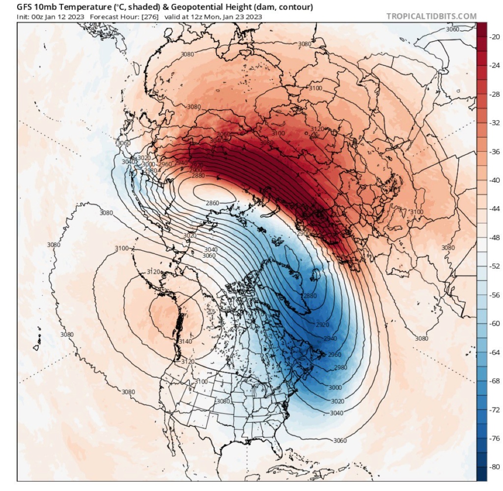
Frank_Wx wrote:Major SSWE still showing up in the very long range of the GFS
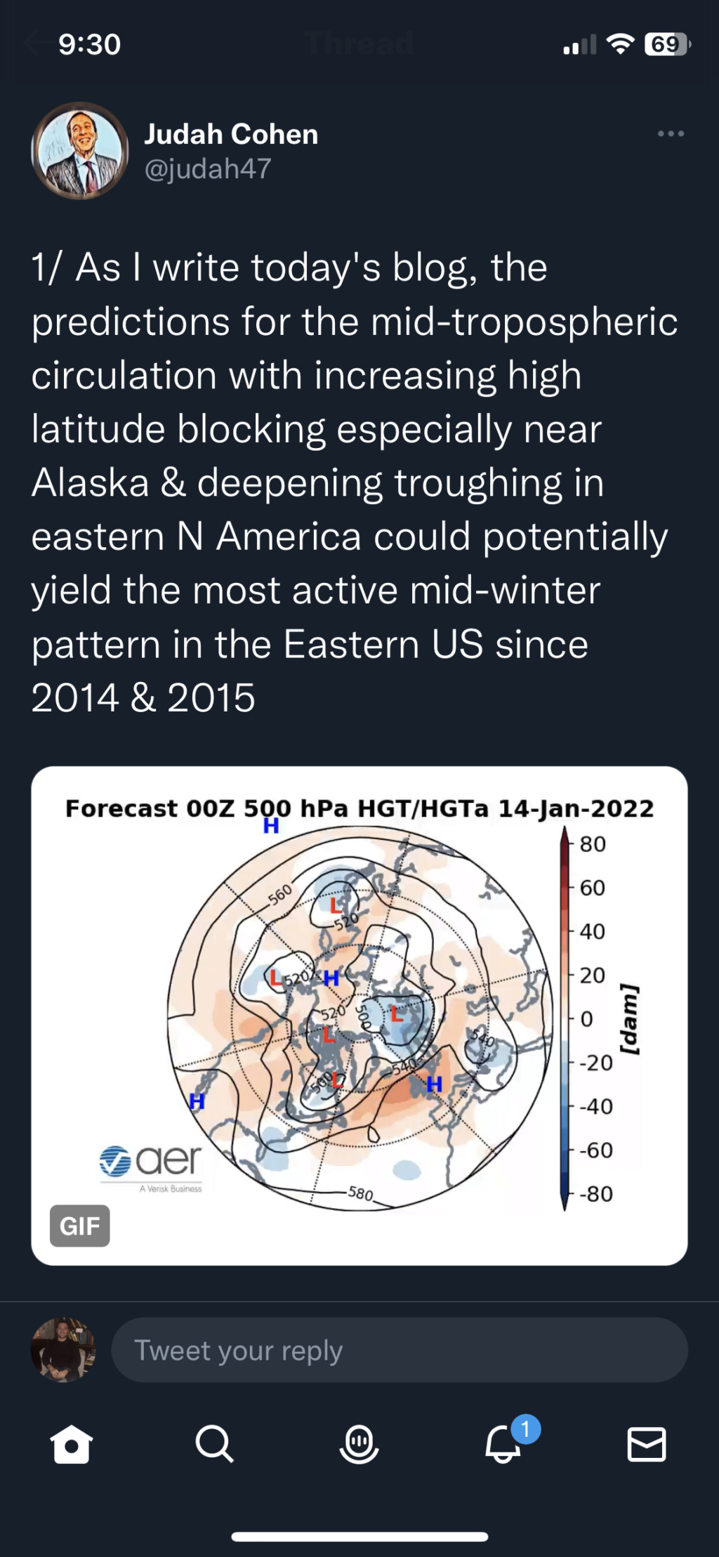
I had a discussion with Judah Cohen on Twitter and he believes we see a SSWE at the end of the month starting about Jan 20th. He is one of the leading experts on this and tie will tell but I'll take a pass on a split unless we have a 2018 redux or 1978 Jan 20 through March edux type splits. Give me a good ol elongation/reflection for a good 30 days and I'll be happier.
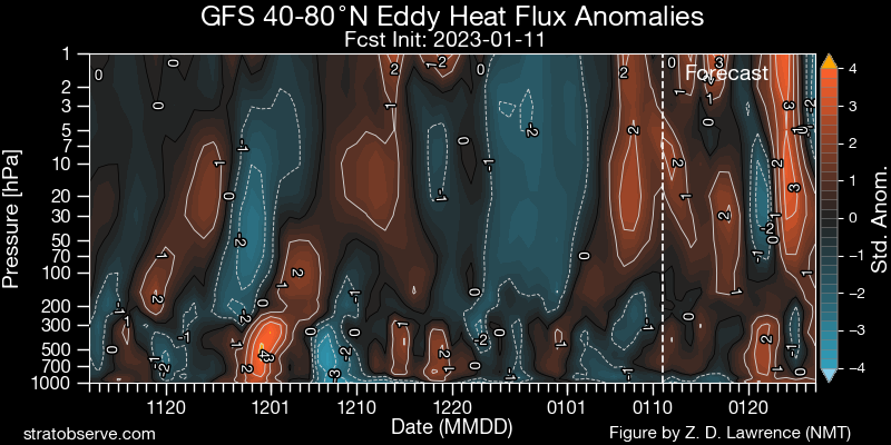
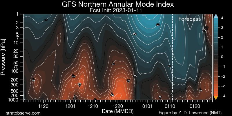
Zonal winds are not where I'd want them to be at this stage but that we can work with since we have a N Annular Mode since mid December

Time will tell but if I see this get pushed back then .................

_________________
Mugs
AKA:King: Snow Weenie
Self Proclaimed
WINTER 2014-15 : 55.12" +.02 for 6 coatings (avg. 35")
WINTER 2015-16 Total - 29.8" (Avg 35")
WINTER 2016-17 : 39.5" so far

amugs- Advanced Forecaster - Mod

- Posts : 15130
Reputation : 213
Join date : 2013-01-07
Age : 54
Location : Hillsdale,NJ
CPcantmeasuresnow likes this post

aiannone- Senior Enthusiast - Mod

- Posts : 4822
Reputation : 92
Join date : 2013-01-07
Location : Saint James, LI (Northwest Suffolk Co.)
phil155 likes this post
 Re: Long Range Thread 25.0
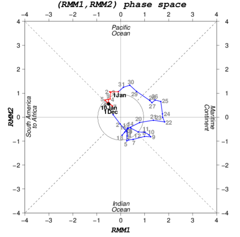
Three straight years of -PDO and La Nina conditions are likely to disappoint. Below is a look of where the MJO has lived since December, and starting just before Christmas and through the New Year, tropical activity has been nonexistent toward the Dateline and isolated in the western tropical Pacific. SSTA's still support La Nina and it has lead to the dominance of the pacific jet across the northern pacific.
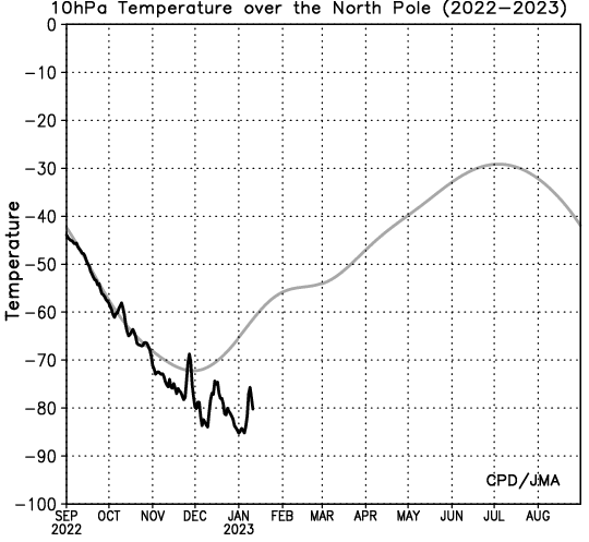
We saw a potent SSWE take place in the middle of December that lead to record cold temperatures, and truthfully was our best chance of seeing snow if it wasn't for unlucky timing. Since that time, we have seen the Strat PV strengthen as evidenced by record cold temperatures at 30hPa just last week. Although the PV remains in a strong state, recent forecasts are showing another warming event taking place around the 25th (+/- 3 days) of January. It remains to be seen whether this will be a temporary disruption like we saw in December, or one that will permanently displace the PV off the Pole. I'm guessing the former than the latter, but I believe it will be a stronger warming event than previous months.
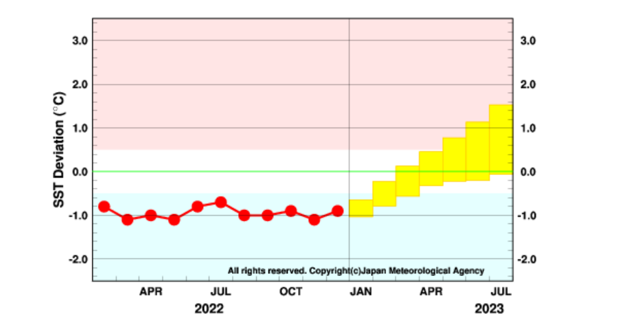
The other piece of positive news is ENSO Ensembles are forecasting La Nina to fade starting in February. Odds are high for an El Nino to develop this summer and last into the '23-'24 winter. Although this is likely to impact more next year than this year, my guess is the transition from negative ENSO to neutral will have an effect to the MJO toward the back half of this winter.
I'm feeling pretty good about February. I still have hopes the last several days of January can produce as well.
_________________
_______________________________________________________________________________________________________
CLICK HERE to view NJ Strong Snowstorm Classifications
MattyICE likes this post
 Re: Long Range Thread 25.0
_________________
Mugs
AKA:King: Snow Weenie
Self Proclaimed
WINTER 2014-15 : 55.12" +.02 for 6 coatings (avg. 35")
WINTER 2015-16 Total - 29.8" (Avg 35")
WINTER 2016-17 : 39.5" so far

amugs- Advanced Forecaster - Mod

- Posts : 15130
Reputation : 213
Join date : 2013-01-07
Age : 54
Location : Hillsdale,NJ
 Re: Long Range Thread 25.0
_________________
Mugs
AKA:King: Snow Weenie
Self Proclaimed
WINTER 2014-15 : 55.12" +.02 for 6 coatings (avg. 35")
WINTER 2015-16 Total - 29.8" (Avg 35")
WINTER 2016-17 : 39.5" so far

amugs- Advanced Forecaster - Mod

- Posts : 15130
Reputation : 213
Join date : 2013-01-07
Age : 54
Location : Hillsdale,NJ
 Re: Long Range Thread 25.0
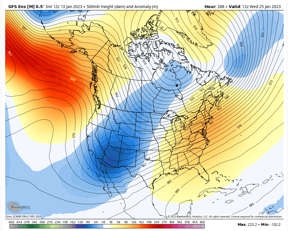
Take a look at this and tell me what you think about Siberia cold around the 20th
Carvin- Posts : 44
Reputation : 2
Join date : 2019-01-09
 Re: Long Range Thread 25.0
_________________
Mugs
AKA:King: Snow Weenie
Self Proclaimed
WINTER 2014-15 : 55.12" +.02 for 6 coatings (avg. 35")
WINTER 2015-16 Total - 29.8" (Avg 35")
WINTER 2016-17 : 39.5" so far

amugs- Advanced Forecaster - Mod

- Posts : 15130
Reputation : 213
Join date : 2013-01-07
Age : 54
Location : Hillsdale,NJ
 Re: Long Range Thread 25.0

dkodgis- Senior Enthusiast

- Posts : 2667
Reputation : 98
Join date : 2013-12-29
 Re: Long Range Thread 25.0
Also here's my call, EL NINO gets muted by Hunga Tonga. It's going to struggle. It happened after Tambora and Pinatubo.
_________________
Mugs
AKA:King: Snow Weenie
Self Proclaimed
WINTER 2014-15 : 55.12" +.02 for 6 coatings (avg. 35")
WINTER 2015-16 Total - 29.8" (Avg 35")
WINTER 2016-17 : 39.5" so far

amugs- Advanced Forecaster - Mod

- Posts : 15130
Reputation : 213
Join date : 2013-01-07
Age : 54
Location : Hillsdale,NJ
 Re: Long Range Thread 25.0

dkodgis- Senior Enthusiast

- Posts : 2667
Reputation : 98
Join date : 2013-12-29
 Re: Long Range Thread 25.0
_________________
Mugs
AKA:King: Snow Weenie
Self Proclaimed
WINTER 2014-15 : 55.12" +.02 for 6 coatings (avg. 35")
WINTER 2015-16 Total - 29.8" (Avg 35")
WINTER 2016-17 : 39.5" so far

amugs- Advanced Forecaster - Mod

- Posts : 15130
Reputation : 213
Join date : 2013-01-07
Age : 54
Location : Hillsdale,NJ

CPcantmeasuresnow- Wx Statistician Guru

- Posts : 7274
Reputation : 230
Join date : 2013-01-07
Age : 103
Location : Eastern Orange County, NY
 Re: Long Range Thread 25.0
It's a fair point CP. Some risks for the Cape not getting snow is PAC air being wrapped into the system and whether or not the ULL captures the mid-level energy in time for an impact. Still not set in stone on that. My thought remains the Cape will get snow and a 30% chance of 6"+. What I'm still not sure about is E LI and starting to think this consolidates a bit too far offshore for our LI friends.
heehaw453- Advanced Forecaster

- Posts : 3908
Reputation : 86
Join date : 2014-01-20
Location : Bedminster Township, PA Elevation 600' ASL
 Re: Long Range Thread 25.0
heehaw453- Advanced Forecaster

- Posts : 3908
Reputation : 86
Join date : 2014-01-20
Location : Bedminster Township, PA Elevation 600' ASL
phil155 likes this post
 Re: Long Range Thread 25.0
heehaw453 wrote:In general there has been transient ridging in the PNA domain. Doesn't last but it does pop up enough to think that a well time s/w can take advantage of it. But what I continue to see and I'm not sure this changes is the SE ridging. It's been prominent since December and in a Nina to completely see that go away is not realistic IMO. For a February 2021 type redux that ridge must get pushed eastward along with AO/NAO support. I'm confident on the coastal plain that if SE ridging stays too close to the area there will be a struggle with boundary layers for just about every storm threat from here on in. The further NW you go will manage to get front end dumps, but the coastal plain will be more of the same. So all in all it's looking to me that the PNA will provide a shot for that one bigger storm to bring the coastal plain to respectable seasonal numbers. And by that I mean 12-16", but unless we start seeing concrete and tangible changes relatively soon to that SE ridge historically bad seasonal totals very well on the table. To be clear I'm not declaring winter over for coastal plain, just feeling we need to start seeing that ridge push eastward off the coast and remain so for several weeks.
How might the SE ridge back off a little one might ask. Well in general we need something to reshuffle the atmosphere. A shift in forcing over the Tropical Pacific is one way, which could result in down stream changes.
Now I'm not sounding any alarms at this stage by any means, believe me you, BUT for the first time in awhile we have negative SOI values. Today is significantly negative. Yesterday was just a hair in the negative territory.
https://www.longpaddock.qld.gov.au/soi/
The absolute number shouldn't be over analyzed; however, IF we can get another 3-4days or more in a row of negative values(say between -5 & -15 +/-), this to me indicates something in the atmosphere is changing in and around the trop Pac around and west of the dateline, and I would expect to see the down stream effects of that shift in forcing in that location to show up in the east about 5-7days later give or take. That said models are already hinting at our next "threat" for later next week. The set up looks like a pressing boundary layer that sinks south of the area and waves of LP that potentially strengthen as they hit the coast with Strong HP to our north providing a cold air source.
Again right now I aint buying anything white. That said if the SOI cooperates, realizing it is by no means the end all be all, I will be more optimistic than I am now that a different outcome is possible. A consistently negative SOI for 4-7days in a row against a background of strong positives, likely indicates changes are amiss. To quote JB it indicates "a cattle prod to the atmosphere".
Well see.
_________________
"In weather and in life, there's no winning and losing; there's only winning and learning."
WINTER 2012/2013 TOTALS 43.65"WINTER 2017/2018 TOTALS 62.85" WINTER 2022/2023 TOTALS 4.9"
WINTER 2013/2014 TOTALS 64.85"WINTER 2018/2019 TOTALS 14.25" WINTER 2023/2024 TOTALS 13.1"
WINTER 2014/2015 TOTALS 71.20"WINTER 2019/2020 TOTALS 6.35"
WINTER 2015/2016 TOTALS 35.00"WINTER 2020/2021 TOTALS 37.75"
WINTER 2016/2017 TOTALS 42.25"WINTER 2021/2022 TOTALS 31.65"

sroc4- Admin

- Posts : 8443
Reputation : 302
Join date : 2013-01-07
Location : Wading River, LI
heehaw453 likes this post
 Re: Long Range Thread 25.0
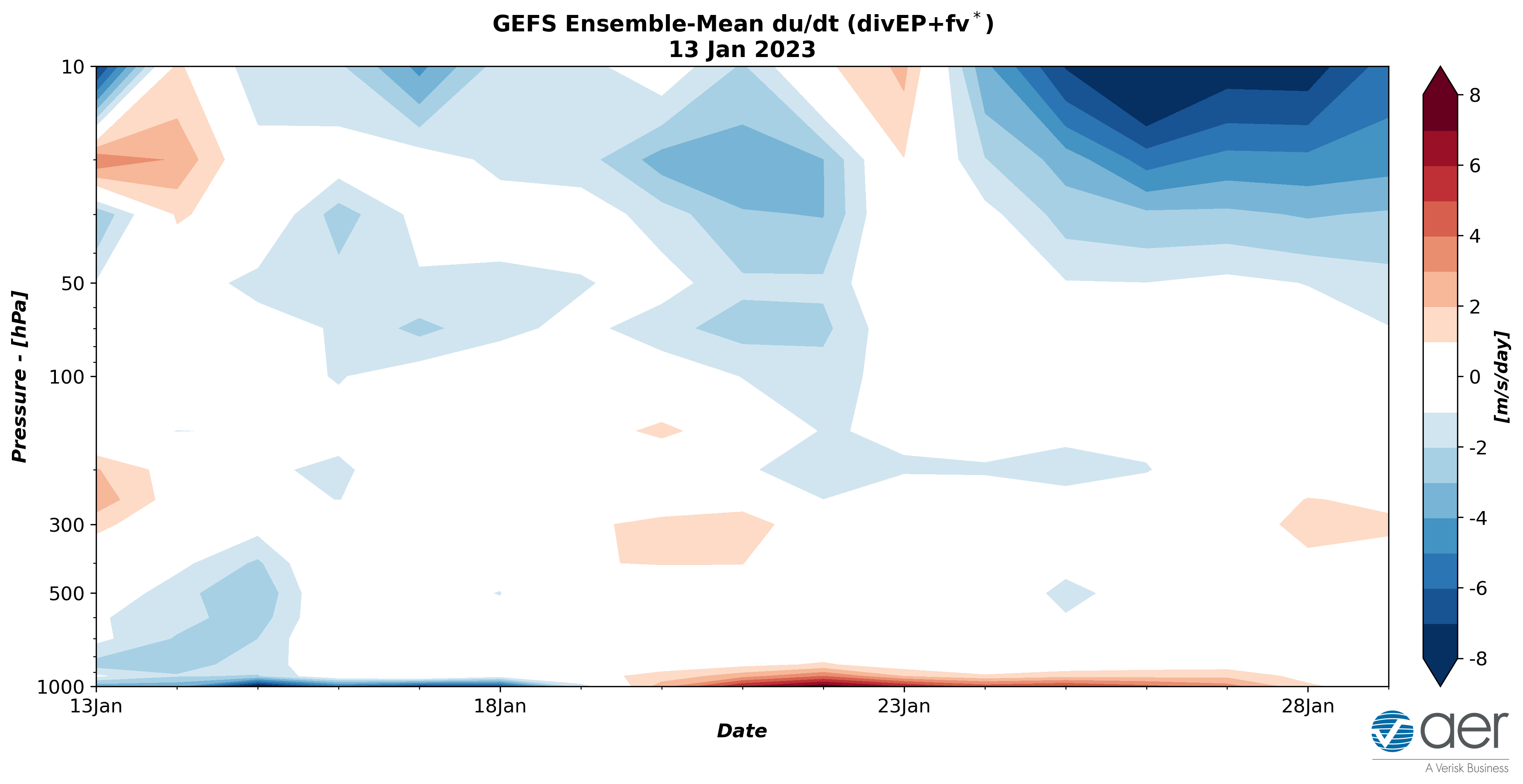
Geek alert! Polar cap diagnostics more robust on weakening of the #PolarVortex (PV). Geopotential height anomaly forecast predicting full column warming & strong heat flux convergence in the polar stratosphere for next week. Explains accelerating model forecast of a weakening PV. pic.twitter.com/uzvxvAK67K
— Judah Cohen (@judah47) January 13, 2023
Even Dr Cohen is starting to beat the drum, a bit more than a little now.
_________________
Mugs
AKA:King: Snow Weenie
Self Proclaimed
WINTER 2014-15 : 55.12" +.02 for 6 coatings (avg. 35")
WINTER 2015-16 Total - 29.8" (Avg 35")
WINTER 2016-17 : 39.5" so far

amugs- Advanced Forecaster - Mod

- Posts : 15130
Reputation : 213
Join date : 2013-01-07
Age : 54
Location : Hillsdale,NJ
phil155 likes this post
 Re: Long Range Thread 25.0
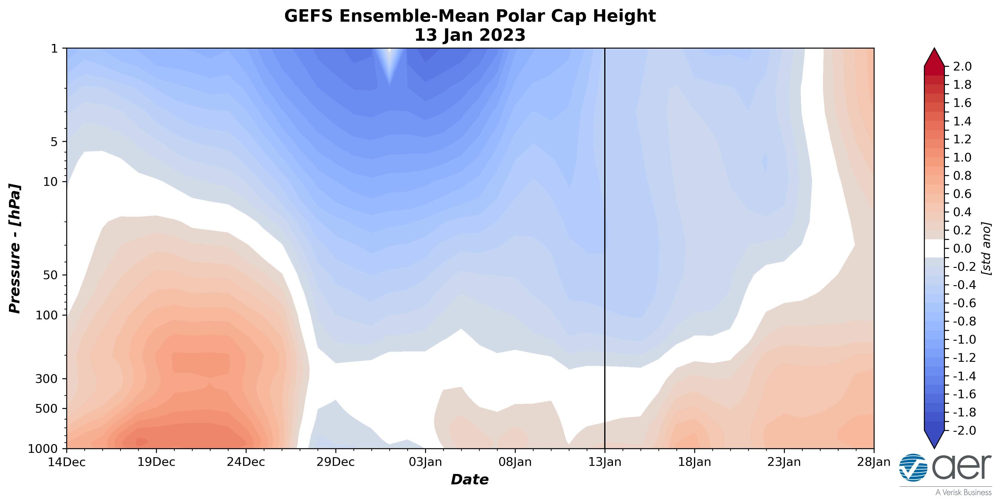
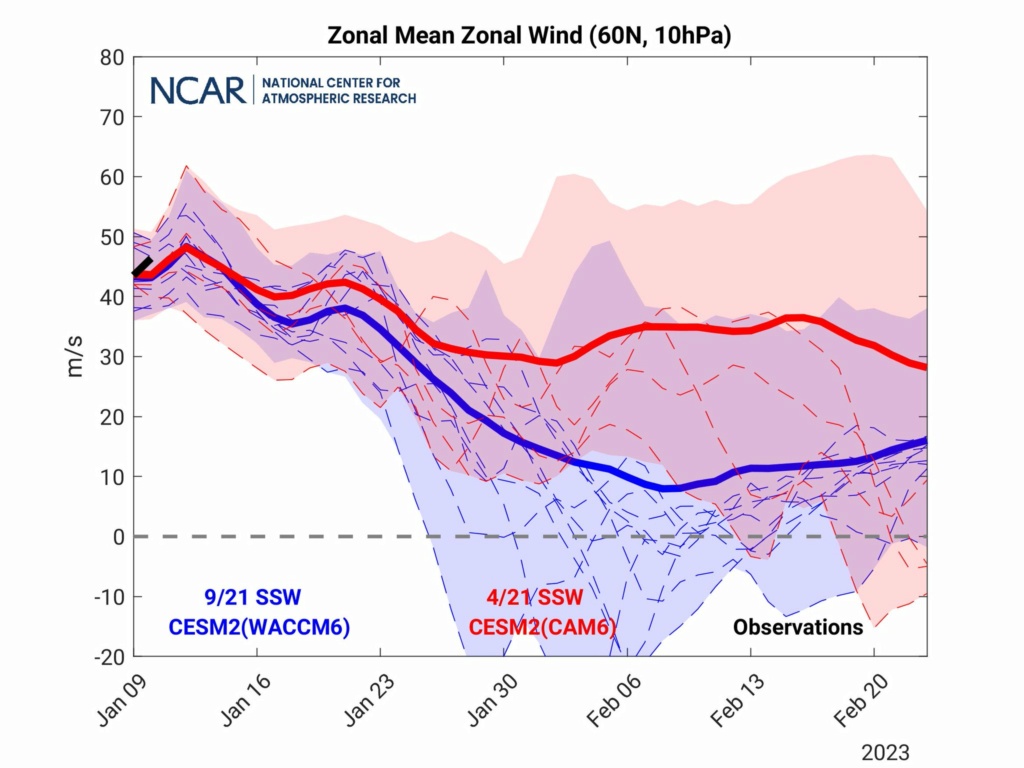
Zonal winds are satrting to slow down as indicated by the blue, and dark at that belwo here!!
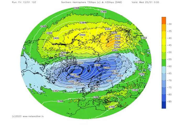
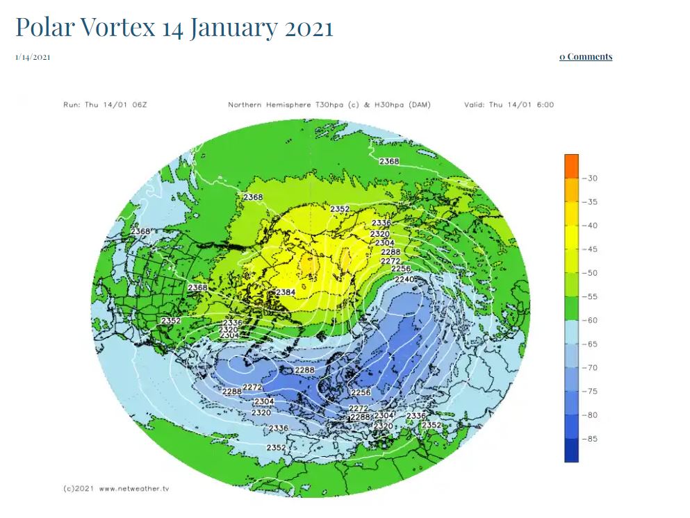
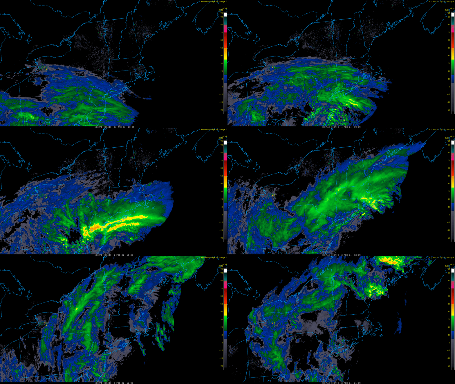
Compared to Jan 14th 2021 - you know what came 2 weeks later???
This......
_________________
Mugs
AKA:King: Snow Weenie
Self Proclaimed
WINTER 2014-15 : 55.12" +.02 for 6 coatings (avg. 35")
WINTER 2015-16 Total - 29.8" (Avg 35")
WINTER 2016-17 : 39.5" so far

amugs- Advanced Forecaster - Mod

- Posts : 15130
Reputation : 213
Join date : 2013-01-07
Age : 54
Location : Hillsdale,NJ
 Re: Long Range Thread 25.0
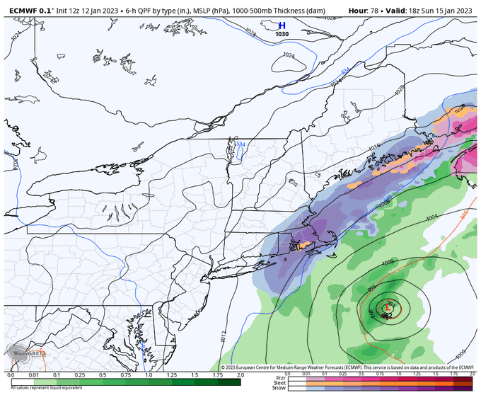
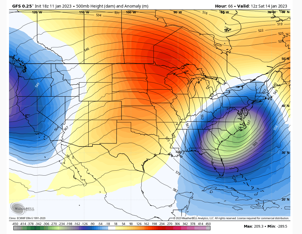
I will be right in that dark red frz zone, great, at least I will not be going anywhere until Tuesday after I get there. If I am leaving to CT Sunday should I go early or later to avoid driving in any wintry precip, haven't had much experience this year I may have forgotten lol?

jmanley32- Senior Enthusiast

- Posts : 20635
Reputation : 108
Join date : 2013-12-12
Age : 43
Location : Yonkers, NY
 Re: Long Range Thread 25.0
jmanley32 wrote:I will be right in that dark red frz zone, great, at least I will not be going anywhere until Tuesday after I get there. If I am leaving to CT Sunday should I go early or later to avoid driving in any wintry precip, haven't had much experience this year I may have forgotten lol?
Jon You may not want to drive at all. Winds 45-55mph and looks like your drive is slated for 10-15" Could get messy.

_________________
"In weather and in life, there's no winning and losing; there's only winning and learning."
WINTER 2012/2013 TOTALS 43.65"WINTER 2017/2018 TOTALS 62.85" WINTER 2022/2023 TOTALS 4.9"
WINTER 2013/2014 TOTALS 64.85"WINTER 2018/2019 TOTALS 14.25" WINTER 2023/2024 TOTALS 13.1"
WINTER 2014/2015 TOTALS 71.20"WINTER 2019/2020 TOTALS 6.35"
WINTER 2015/2016 TOTALS 35.00"WINTER 2020/2021 TOTALS 37.75"
WINTER 2016/2017 TOTALS 42.25"WINTER 2021/2022 TOTALS 31.65"

sroc4- Admin

- Posts : 8443
Reputation : 302
Join date : 2013-01-07
Location : Wading River, LI
heehaw453- Advanced Forecaster

- Posts : 3908
Reputation : 86
Join date : 2014-01-20
Location : Bedminster Township, PA Elevation 600' ASL
Page 26 of 40 •  1 ... 14 ... 25, 26, 27 ... 33 ... 40
|
|
|

 Home
Home