JAN 28th-30th 2024 Potential system compliments of a +PNA
+15
Grselig
weatherwatchermom
CPcantmeasuresnow
nutleyblizzard
essexcountypete
MattyICE
amugs
kalleg
Frank_Wx
Irish
aiannone
SENJsnowman
billg315
heehaw453
sroc4
19 posters
Page 5 of 5 •  1, 2, 3, 4, 5
 Re: JAN 28th-30th 2024 Potential system compliments of a +PNA
dkodgis wrote:Anything that could go wrong did
I disagree Damian. This pretty much went according to plan given the atmosphere in its current state. Hostile MJO phase with amplitude. After all we are in the "Jan Thaw" and had a shot. Atmosphere appears to be heading back towards a more favorable state over the next 10days or so, give or take, with additional opportunities on the table during that time of transition. Cautious optimism needed for February.
sroc4- Admin

- Posts : 8463
Join date : 2013-01-07
kalleg likes this post
 Re: JAN 28th-30th 2024 Potential system compliments of a +PNA

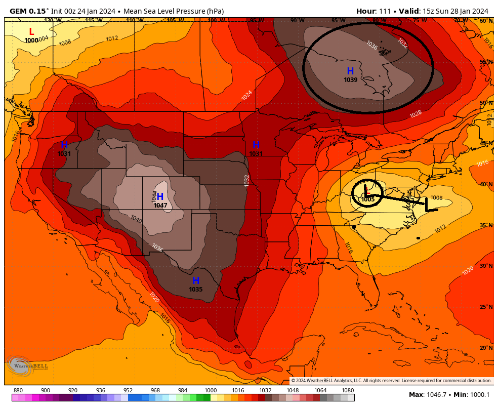
The reality was it was a race between the Arctic HP and the Primary low such that when the transfer took place where was the Arctic HP and how strong was it? See above. Below was the CMC 00z run on the 24th when it showed one of the colder solns. Look at how strong the HP is to our north and to the west, as well as the positioning; esp the one to the north.

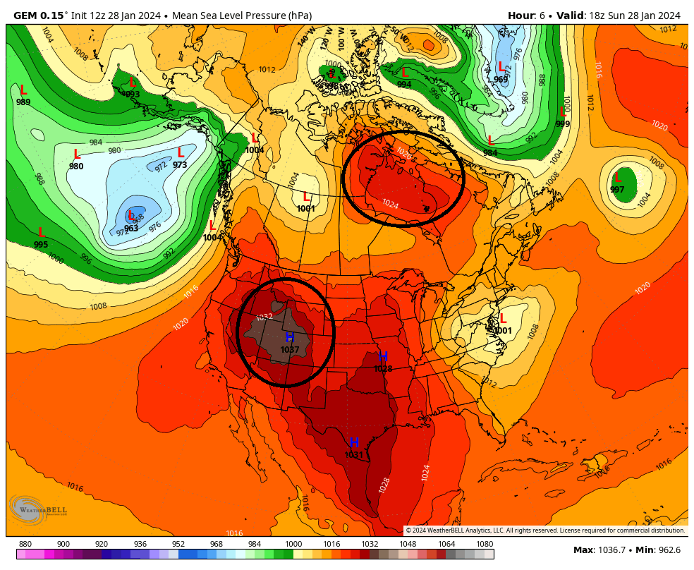
Now take a look at the CMC from todays 12z run valid for 1pm today. Notice how far north the HP still is and how much weaker it is in reality compared to the forecast from a four days ago.

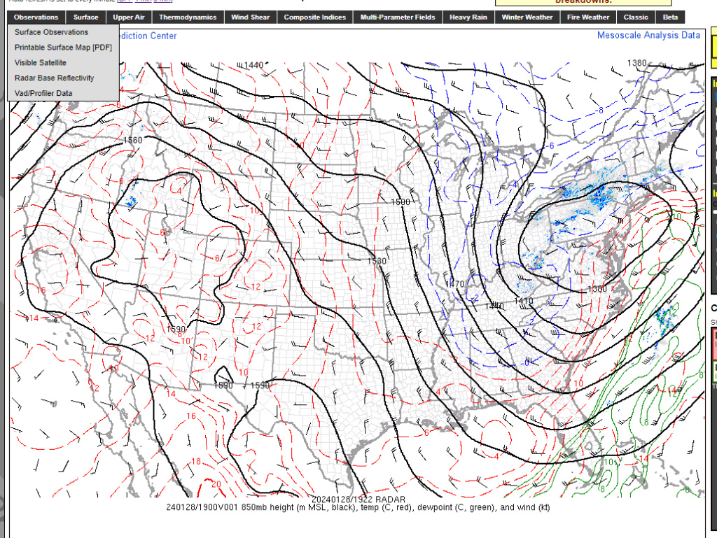
Here is your current meso anaysis. If we had an HP parked in the position I have outlined this would be a beast for all with a Miller B transfering off the coast in the position its taking place. A damn shame for sure, but again not to beat the dead horse but with the MJO is in an extremely hostile state, none of this was unexpected.

sroc4- Admin

- Posts : 8463
Join date : 2013-01-07
 Re: JAN 28th-30th 2024 Potential system compliments of a +PNA
Scott, what I meant was this storm for a while signaled an event or not and it was not. Taking this one storm what could have been wasn’t underlining the complexity of nature.

dkodgis- Senior Enthusiast

- Posts : 2694
Reputation : 98
Join date : 2013-12-29
sroc4 likes this post
 Re: JAN 28th-30th 2024 Potential system compliments of a +PNA
sroc4 wrote:
So Im not quite sure how to upload the GIF such that it appears right in the thread without having to click the link, but well I cant. That said if you click the link above you will see it. Apparently some of the Hi Res models are potentially hinting at a quick hitting change over between approx 2am and 4am tomorrow am for some of the coastal and eastern sections. If true, some of us on Long Island could wake to a quick coating to maybe an inch or so in the am. The link above is the Hrrr, but the 3 and 12k NAM, and possibly 2.5k RGEM are all hinting at it as well. I guess it boils down to the timing of when the last slug of moisture moves out compared to the temps crashing. We'll see. With the MJO in an extremely hostile state this really was never our storm as outlined from the beginning. Anything squeezed out of this will be a bonus.
The GIF needs to be hosted somewhere that is publicly accessible on the internet and then you can embed directly into the post. If you download GIF you create on Weatherbell and then upload to something like Dropbox (with anonymous access) that'd work. Just would need the URI of that Dropbox location for the embed into the post.
heehaw453- Advanced Forecaster

- Posts : 3944
Reputation : 86
Join date : 2014-01-20
Location : Bedminster Township, PA Elevation 600' ASL
 Re: JAN 28th-30th 2024 Potential system compliments of a +PNA
sroc4 wrote:
The reality was it was a race between the Arctic HP and the Primary low such that when the transfer took place where was the Arctic HP and how strong was it? See above. Below was the CMC 00z run on the 24th when it showed one of the colder solns. Look at how strong the HP is to our north and to the west, as well as the positioning; esp the one to the north.
Now take a look at the CMC from todays 12z run valid for 1pm today. Notice how far north the HP still is and how much weaker it is in reality compared to the forecast from a four days ago.
Here is your current meso anaysis. If we had an HP parked in the position I have outlined this would be a beast for all with a Miller B transfering off the coast in the position its taking place. A damn shame for sure, but again not to beat the dead horse but with the MJO is in an extremely hostile state, none of this was unexpected.
Nice post. IMO the models did a very good job inside 48-72 hours with one. It was clear the last few days this was going to be bad timing. 10:1 snow maps with this setup are completely irrelevant misleading more like it.
heehaw453- Advanced Forecaster

- Posts : 3944
Reputation : 86
Join date : 2014-01-20
Location : Bedminster Township, PA Elevation 600' ASL
 Re: JAN 28th-30th 2024 Potential system compliments of a +PNA
33.4° light rain and snow.
Just give me dry rather than this slow and deliberate torture
Just give me dry rather than this slow and deliberate torture

CPcantmeasuresnow- Wx Statistician Guru

- Posts : 7289
Reputation : 230
Join date : 2013-01-08
Age : 103
Location : Eastern Orange County, NY
docstox12 likes this post
 Re: JAN 28th-30th 2024 Potential system compliments of a +PNA
CPcantmeasuresnow wrote:33.4° light rain and snow.
Just give me dry rather than this slow and deliberate torture
The latest NWS model runs seem to say stick a fork in this one. Cooked. I tend to agree. Look at the 850's. It's not consolidated and it might get there, but probably too late. It usually comes down to the fundamental thing that Miller B's more often than not don't end well for these parts especially at and south of NYC. The primary usually gets too far north and the secondary takes too long to get its act together. It just sucks this one actually could have worked out.


heehaw453- Advanced Forecaster

- Posts : 3944
Reputation : 86
Join date : 2014-01-20
Location : Bedminster Township, PA Elevation 600' ASL
 Re: JAN 28th-30th 2024 Potential system compliments of a +PNA
NWS for New Hope--
Hard to believe that any snow will actually come our way, a bit strange that it's even mentioned, given the temperatures...wishful thinking on the part of this NWS forecaster???
Areas of drizzle with a chance of rain before 5pm, then rain likely with areas of drizzle after 5pm. Cloudy, with a high near 40. Northeast wind around 15 mph. Chance of precipitation is 60%. New precipitation amounts of less than a tenth of an inch possible.
Rain likely before 3am, then a chance of rain and snow. Cloudy, with a low around 35. North wind around 10 mph. Chance of precipitation is 60%. Little or no snow accumulation expected.
Hard to believe that any snow will actually come our way, a bit strange that it's even mentioned, given the temperatures...wishful thinking on the part of this NWS forecaster???
This Afternoon
Areas of drizzle with a chance of rain before 5pm, then rain likely with areas of drizzle after 5pm. Cloudy, with a high near 40. Northeast wind around 15 mph. Chance of precipitation is 60%. New precipitation amounts of less than a tenth of an inch possible.
Tonight
Rain likely before 3am, then a chance of rain and snow. Cloudy, with a low around 35. North wind around 10 mph. Chance of precipitation is 60%. Little or no snow accumulation expected.
kalleg- Posts : 160
Reputation : 2
Join date : 2013-01-15
Location : New Hope, PA
 Re: JAN 28th-30th 2024 Potential system compliments of a +PNA
Damien I do agree with you from the point that we have had the tracks but no cold air. Models have been horrible this year forecasting everything from storms to temperatures. Phases 1 and 2 gave us 10 days where we had about 6-10" in total here in NNJ. That would be expected in one storm in these phases. The HP is to weak, too late in getting here, not in the right position, flow to progressive, storm mid levels go west, don't consolidate etc etc. The explanations are like excuses when it doesn't happen we explain why. Sadly people and especially weenies don't want it, they just want white gold n cold. This winter has been an F for sure. Again reminds me a lot of 97-98.
Again for reasons outlined everything for a snowstorm that can go wrong has this winter dating back to Dec.
Feb 2nd ish we start to turn the worm for a better pattern. Time will tell.
Again for reasons outlined everything for a snowstorm that can go wrong has this winter dating back to Dec.
Feb 2nd ish we start to turn the worm for a better pattern. Time will tell.
_________________
Mugs
AKA:King: Snow Weenie
Self Proclaimed
WINTER 2014-15 : 55.12" +.02 for 6 coatings (avg. 35")
WINTER 2015-16 Total - 29.8" (Avg 35")
WINTER 2016-17 : 39.5" so far

amugs- Advanced Forecaster - Mod

- Posts : 15159
Reputation : 213
Join date : 2013-01-07
Age : 54
Location : Hillsdale,NJ
sroc4, docstox12, CPcantmeasuresnow, weatherwatchermom and SENJsnowman like this post
 Re: JAN 28th-30th 2024 Potential system compliments of a +PNA
January is not an F IMBY. I'd give it a C+. +1.5 temps, 10" of snow. Snow pack for 9 days which elevates it to C+ from just a C. December absolutely an F.
heehaw453- Advanced Forecaster

- Posts : 3944
Reputation : 86
Join date : 2014-01-20
Location : Bedminster Township, PA Elevation 600' ASL
kalleg likes this post
 Re: JAN 28th-30th 2024 Potential system compliments of a +PNA
heehaw453 wrote:CPcantmeasuresnow wrote:33.4° light rain and snow.
Just give me dry rather than this slow and deliberate torture
The latest NWS model runs seem to say stick a fork in this one. Cooked. I tend to agree. Look at the 850's. It's not consolidated and it might get there, but probably too late. It usually comes down to the fundamental thing that Miller B's more often than not don't end well for these parts especially at and south of NYC. The primary usually gets too far north and the secondary takes too long to get its act together. It just sucks this one actually could have worked out.
Never have been a fan of Miller B's for the reasons you state.More often than not they disappoint.Too many moving parts to deal with for me.

docstox12- Wx Statistician Guru

- Posts : 8620
Reputation : 222
Join date : 2013-01-07
Age : 74
Location : Monroe NY
kalleg and heehaw453 like this post
 Re: JAN 28th-30th 2024 Potential system compliments of a +PNA
heehaw453 wrote:January is not an F IMBY. I'd give it a C+. +1.5 temps, 10" of snow. Snow pack for 9 days which elevates it to C+ from just a C. December absolutely an F.
I'd agree overall. Snowfall for the month is 13.8 inches, about average, there were 14 days with snow cover but of course the elephant in the room is the +3° above normal. January gets a C to C+. It certainly blows away last January.

CPcantmeasuresnow- Wx Statistician Guru

- Posts : 7289
Reputation : 230
Join date : 2013-01-08
Age : 103
Location : Eastern Orange County, NY
heehaw453 likes this post
 Re: JAN 28th-30th 2024 Potential system compliments of a +PNA
To complement what Scott pointed out earlier. This is from NWS:
Also interesting to note, as surface low
pressure passes to the south and east, gusty NE winds will
become more northerly through the night. For Long Island, this
will be off the Long Island Sound. Multiple high res models are
picking on a west to east enhancement in the precipitation
across Long Island. This is due to a moist upslope component
which has been noted in past events. It doesn`t take much
elevation to help squeeze out a bit more. This may be enough to
provide a coating of snow across this area.
_________________
-Alex Iannone-

aiannone- Senior Enthusiast - Mod

- Posts : 4828
Reputation : 92
Join date : 2013-01-07
Location : Saint James, LI (Northwest Suffolk Co.)

1190ftalt- Pro Enthusiast

- Posts : 411
Reputation : 10
Join date : 2013-12-13
Location : Stillwater, NJ
 Re: JAN 28th-30th 2024 Potential system compliments of a +PNA
33 degrees, light snow, calm winds.About 1/4 inch OTG and radar shows it's over soon.

docstox12- Wx Statistician Guru

- Posts : 8620
Reputation : 222
Join date : 2013-01-07
Age : 74
Location : Monroe NY
 Re: JAN 28th-30th 2024 Potential system compliments of a +PNA
_________________
"In weather and in life, there's no winning and losing; there's only winning and learning."
WINTER 2012/2013 TOTALS 43.65"WINTER 2017/2018 TOTALS 62.85" WINTER 2022/2023 TOTALS 4.9"
WINTER 2013/2014 TOTALS 64.85"WINTER 2018/2019 TOTALS 14.25" WINTER 2023/2024 TOTALS 13.1"
WINTER 2014/2015 TOTALS 71.20"WINTER 2019/2020 TOTALS 6.35" WINTER 2024/2025 TOTALS 0.00
WINTER 2015/2016 TOTALS 35.00"WINTER 2020/2021 TOTALS 37.75"
WINTER 2016/2017 TOTALS 42.25"WINTER 2021/2022 TOTALS 31.65"

sroc4- Admin

- Posts : 8463
Reputation : 302
Join date : 2013-01-07
Location : Wading River, LI
docstox12, 1190ftalt and SENJsnowman like this post
 Re: JAN 28th-30th 2024 Potential system compliments of a +PNA
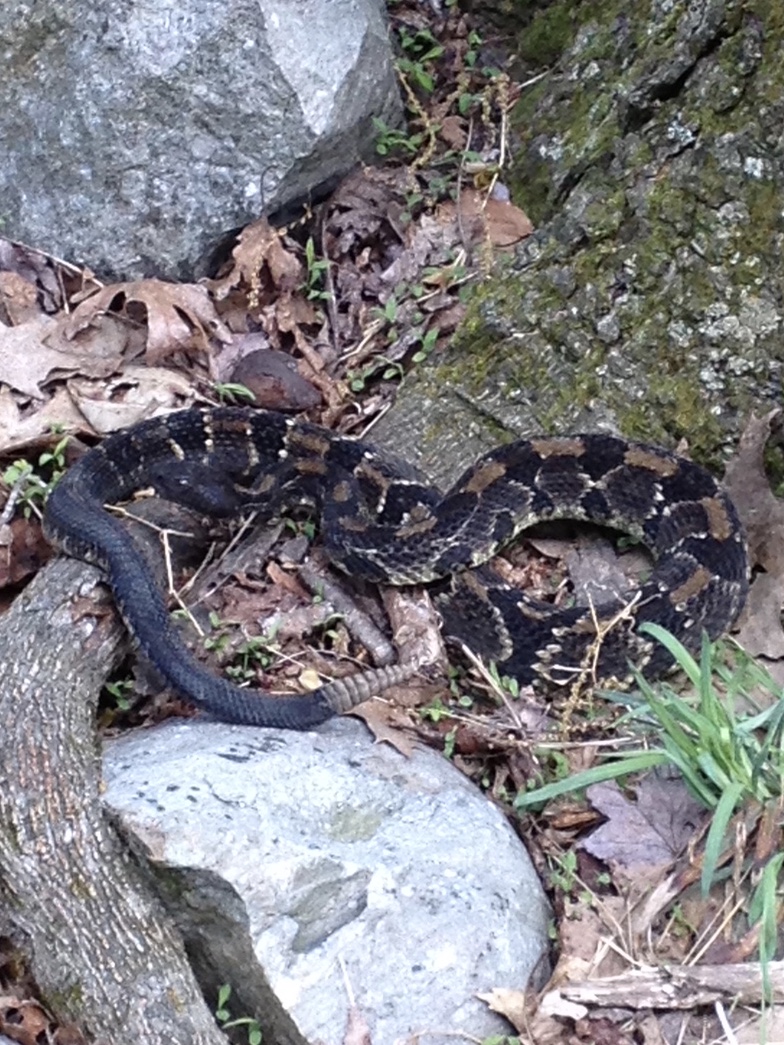
Yeah, I’ll stick with the deer, rodents and occasional fox. Rattlers and bears…oh my!
38* with a cold drizzle in Long Branch, a day and a half of cold rain.
SENJsnowman- Senior Enthusiast

- Posts : 1202
Reputation : 61
Join date : 2017-01-06
Age : 51
Location : Long Branch, NJ
1190ftalt likes this post
 Re: JAN 28th-30th 2024 Potential system compliments of a +PNA
30.9 and snowing moderately for the last hour and nothing shows on radar, weird.
Willactually have to measure when it stops. Looks like a little over an inch.
Willactually have to measure when it stops. Looks like a little over an inch.

CPcantmeasuresnow- Wx Statistician Guru

- Posts : 7289
Reputation : 230
Join date : 2013-01-08
Age : 103
Location : Eastern Orange County, NY
sroc4, heehaw453 and SENJsnowman like this post
 Re: JAN 28th-30th 2024 Potential system compliments of a +PNA
Yep. We have that up here in Orange too. Bobcat. Weasel. And Fischer cats which are no joke at at all. They have teeth like nobody’s beeswax

dkodgis- Senior Enthusiast

- Posts : 2694
Reputation : 98
Join date : 2013-12-29
1190ftalt likes this post
 Re: JAN 28th-30th 2024 Potential system compliments of a +PNA
Actually picked up .7 inches overnight bringing the storm total to 0.7 inches. At least it's white outside again.
14.5 inches for the month, acceptable.
14.5 inches for the month, acceptable.

CPcantmeasuresnow- Wx Statistician Guru

- Posts : 7289
Reputation : 230
Join date : 2013-01-08
Age : 103
Location : Eastern Orange County, NY
sroc4, docstox12, kalleg, 1190ftalt and heehaw453 like this post
 Re: JAN 28th-30th 2024 Potential system compliments of a +PNA
.5 inch here .32 degrees, cloudy, calm winds.
Great pics talt! 30 or so years ago when hiking with a Pal,heard and saw a Rattler a little off one of the trails in the Ramapo Mountain Reservation in Mahwah.A kid from Ramapo College was hiking up there and got bit by a Copperhead and died.Where I am in Monroe NY have seen a family of foxes, a couple of bear sightings, many deer, hawks and once Bald Eagle was perched in one of my trees.People were stopping to take pictures.Rabbits and coyotes around as well.
Great pics talt! 30 or so years ago when hiking with a Pal,heard and saw a Rattler a little off one of the trails in the Ramapo Mountain Reservation in Mahwah.A kid from Ramapo College was hiking up there and got bit by a Copperhead and died.Where I am in Monroe NY have seen a family of foxes, a couple of bear sightings, many deer, hawks and once Bald Eagle was perched in one of my trees.People were stopping to take pictures.Rabbits and coyotes around as well.

docstox12- Wx Statistician Guru

- Posts : 8620
Reputation : 222
Join date : 2013-01-07
Age : 74
Location : Monroe NY
CPcantmeasuresnow, 1190ftalt and heehaw453 like this post
 Re: JAN 28th-30th 2024 Potential system compliments of a +PNA
32 degrees this morning, ice on cars, went out to 206 to get a breakfast sandwich and saw many cars with Pennsylvania and New York plate’s heading south on 206 with 2 inches of snow on there roofs. Probably coming from elevated places in pocoonos ( place on Rt 206 is 15 minutes from the Milford or Dingmans Bridge) and don’t know where the NY cars could have gotten the snow maybe Spaarrow Bush or Katskills, nice to see the snow on the cars and GOOD FOR THEM !
Good Luck
Good Luck

1190ftalt- Pro Enthusiast

- Posts : 411
Reputation : 10
Join date : 2013-12-13
Location : Stillwater, NJ
docstox12 and CPcantmeasuresnow like this post
 Re: JAN 28th-30th 2024 Potential system compliments of a +PNA
1190ftalt wrote:32 degrees this morning, ice on cars, went out to 206 to get a breakfast sandwich and saw many cars with Pennsylvania and New York plate’s heading south on 206 with 2 inches of snow on there roofs. Probably coming from elevated places in pocoonos ( place on Rt 206 is 15 minutes from the Milford or Dingmans Bridge) and don’t know where the NY cars could have gotten the snow maybe Spaarrow Bush or Katskills, nice to see the snow on the cars and GOOD FOR THEM !
Good Luck
Milford is a delightful and quaint little town. And those who have been on Dingmans Bridge know what a treat that experience is. This bridge literally has a (friendly) troll on it that you have to pay a dollar or two before he/she lets you pass!
Also note Talt’s using the K in homage to the authentic spelling of the Kaatskills. Good stuff, imo! Happy Monday morning all!
SENJsnowman- Senior Enthusiast

- Posts : 1202
Reputation : 61
Join date : 2017-01-06
Age : 51
Location : Long Branch, NJ
docstox12 and kalleg like this post
Page 5 of 5 •  1, 2, 3, 4, 5
Permissions in this forum:
You cannot reply to topics in this forum
 Home
Home


