February 17th 2024 Snow Observations
+33
SkiSeadooJoe
CPcantmeasuresnow
richb521
dkodgis
jaydoy
Coachgriff
MikeA
crippo84
brownie
weatherwatchermom
WeatherBob
heehaw453
aiannone
phil155
Goalscore1
1190ftalt
justdrew
NJBear
Irish
GreyBeard
essexcountypete
SoulSingMG
docstox12
billg315
frank 638
SENJsnowman
jmanley32
MattyICE
amugs
sroc4
nutleyblizzard
mmanisca
Frank_Wx
37 posters
Page 1 of 6 • 1, 2, 3, 4, 5, 6 
 February 17th 2024 Snow Observations
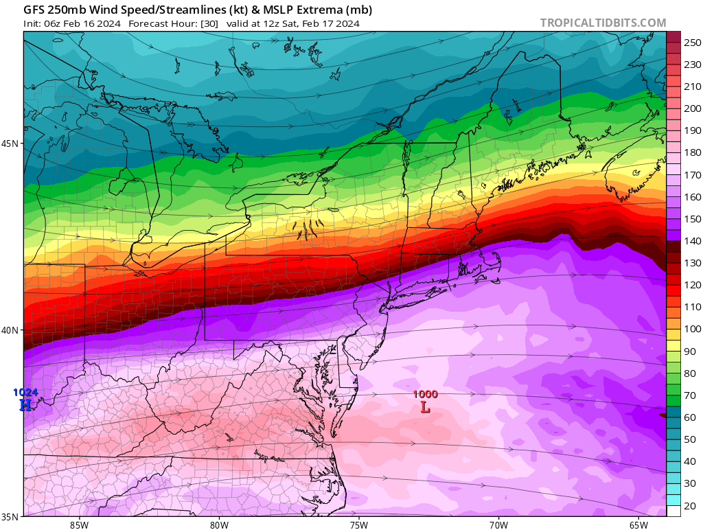
Round 2! Areas that got skunked last storm have a chance to make up for it with this one. There’s general consensus that low pressure will develop over Virginia which is where our baroclinic zone currently lives. Along this zone is where you’ll find the best dynamics that will lead to moderate snowfall accumulations.


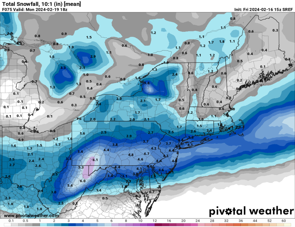
The top image is your 250mb jet steak that is modeled to pass through the Mid Atlantic. You have mid level energy transcending south out of the polar region thanks for a very robust PNA ridge. The bottom image is your 700mb frontogenesis which is your “jackpot” zone for this event. Although the surface low is weak, at 1000mb give or take, there will be banding along the baroclinic area capable of 1-1.5”/hour.
DC to SNJ are looking at a 4-8” snowfall. Philly to CNJ 3-6”. NNJ, including NYC and LI, look more like 1-3” but it’s a tough forecast. If we see a trend north (sound familiar?) it’s possible some of the better dynamics spread north as well which could put more areas under 3-6”. Some models such as the NAM actually show subsidence, or dry air, over much of NNJ/NYC leading up to the storm. It could be difficult to erode that away. So that’s also a factor for keeping snow amounts on the lower end there.
Good luck SNJ!!!
_________________
_______________________________________________________________________________________________________
CLICK HERE to view NJ Strong Snowstorm Classifications
docstox12, SkiSeadooJoe, kalleg, mmanisca, Shorebird, richb521, larryrock72 and like this post
 Re: February 17th 2024 Snow Observations
So far 12z looking up for us here on Long Island. Hoping for a solid 2-4 inches..

mmanisca- Pro Enthusiast

- Posts : 299
Reputation : 3
Join date : 2013-01-23
Age : 66
Location : Deer Park, Long Island
sroc4 and SENJsnowman like this post
 Re: February 17th 2024 Snow Observations
Good trends today with the 12Z model suite. NAM, RGEM, and GFS have continued to tick north. Advisory level amounts encompass most of the area. 3-5” looks like a good bet.

nutleyblizzard- Senior Enthusiast

- Posts : 1963
Reputation : 41
Join date : 2014-01-30
Age : 58
Location : Nutley, new jersey
SENJsnowman and MattyICE like this post
 Re: February 17th 2024 Snow Observations
nutleyblizzard wrote:Good trends today with the 12Z model suite. NAM, RGEM, and GFS have continued to tick north. Advisory level amounts encompass most of the area. 3-5” looks like a good bet.
Look at 12z HRRR for some real excitement
_________________
"In weather and in life, there's no winning and losing; there's only winning and learning."
WINTER 2012/2013 TOTALS 43.65"WINTER 2017/2018 TOTALS 62.85" WINTER 2022/2023 TOTALS 4.9"
WINTER 2013/2014 TOTALS 64.85"WINTER 2018/2019 TOTALS 14.25" WINTER 2023/2024 TOTALS 13.1"
WINTER 2014/2015 TOTALS 71.20"WINTER 2019/2020 TOTALS 6.35" WINTER 2024/2025 TOTALS 0.00
WINTER 2015/2016 TOTALS 35.00"WINTER 2020/2021 TOTALS 37.75"
WINTER 2016/2017 TOTALS 42.25"WINTER 2021/2022 TOTALS 31.65"

sroc4- Admin

- Posts : 8458
Reputation : 302
Join date : 2013-01-07
Location : Wading River, LI
CPcantmeasuresnow, mmanisca and MattyICE like this post
 Re: February 17th 2024 Snow Observations
SHORT TERM /6 PM THIS EVENING THROUGH SATURDAY NIGHT/...
-- Changed Discussion --
Starting to see the new 12z models coming in showing a bump north with slightly higher liquid equivalents and more organized lift. Will be assessing the rest of the 12z guidance and any expansion of the Advisory will occur with the afternoon package.


-- Changed Discussion --
Starting to see the new 12z models coming in showing a bump north with slightly higher liquid equivalents and more organized lift. Will be assessing the rest of the 12z guidance and any expansion of the Advisory will occur with the afternoon package.
_________________
Mugs
AKA:King: Snow Weenie
Self Proclaimed
WINTER 2014-15 : 55.12" +.02 for 6 coatings (avg. 35")
WINTER 2015-16 Total - 29.8" (Avg 35")
WINTER 2016-17 : 39.5" so far

amugs- Advanced Forecaster - Mod

- Posts : 15148
Reputation : 213
Join date : 2013-01-07
Age : 54
Location : Hillsdale,NJ
CPcantmeasuresnow and SENJsnowman like this post
 Re: February 17th 2024 Snow Observations
12z GFS ticks N - another one and 3-4" very doable for NNJ and NYC Metro


Gives reason to pause when it is this moisture laden for a clipper.
Heehaw 200/250Jet enhancing with STJ a bit? Grading heavily before break so no time here brother n sisters


Gives reason to pause when it is this moisture laden for a clipper.
Heehaw 200/250Jet enhancing with STJ a bit? Grading heavily before break so no time here brother n sisters
_________________
Mugs
AKA:King: Snow Weenie
Self Proclaimed
WINTER 2014-15 : 55.12" +.02 for 6 coatings (avg. 35")
WINTER 2015-16 Total - 29.8" (Avg 35")
WINTER 2016-17 : 39.5" so far

amugs- Advanced Forecaster - Mod

- Posts : 15148
Reputation : 213
Join date : 2013-01-07
Age : 54
Location : Hillsdale,NJ
CPcantmeasuresnow likes this post
 Re: February 17th 2024 Snow Observations
Expect advisories from Upton this afternoon!
MattyICE- Advanced Forecaster

- Posts : 249
Reputation : 6
Join date : 2017-11-10
Age : 39
Location : Clifton, NJ (Eastern Passaic County)
mmanisca likes this post
 Re: February 17th 2024 Snow Observations
So 0.3-0.4 with this would be 5-6 inches? It is 39 degrees, how is it possible there could be such high ratios?

jmanley32- Senior Enthusiast

- Posts : 20645
Reputation : 108
Join date : 2013-12-12
Age : 43
Location : Yonkers, NY
 Re: February 17th 2024 Snow Observations
Probably, we will see, IMBY 3 incjhes 10:1, so if we get 15:1 or higher thats almost warning level snow (I believe here it is 6 or more (I was happy with 1-3 so if we see anything more thats great. This will be a fluffy snow correct? Not a back breaker like last?MattyICE wrote:Expect advisories from Upton this afternoon!

jmanley32- Senior Enthusiast

- Posts : 20645
Reputation : 108
Join date : 2013-12-12
Age : 43
Location : Yonkers, NY
 Re: February 17th 2024 Snow Observations
possible warning level snows with ratios in central NJ. High end WWA north of there into LI NYC and most of westchester per this run. GFS def has been consistent in moving north past several runs. Just like last one this seems to be the theme this year.amugs wrote:12z GFS ticks N - another one and 3-4" very doable for NNJ and NYC Metro
Gives reason to pause when it is this moisture laden for a clipper.
Heehaw 200/250Jet enhancing with STJ a bit? Grading heavily before break so no time here brother n sisters

jmanley32- Senior Enthusiast

- Posts : 20645
Reputation : 108
Join date : 2013-12-12
Age : 43
Location : Yonkers, NY
 Re: February 17th 2024 Snow Observations
jmanley32 wrote:So 0.3-0.4 with this would be 5-6 inches? It is 39 degrees, how is it possible there could be such high ratios?
Is it snowing now???

_________________
"In weather and in life, there's no winning and losing; there's only winning and learning."
WINTER 2012/2013 TOTALS 43.65"WINTER 2017/2018 TOTALS 62.85" WINTER 2022/2023 TOTALS 4.9"
WINTER 2013/2014 TOTALS 64.85"WINTER 2018/2019 TOTALS 14.25" WINTER 2023/2024 TOTALS 13.1"
WINTER 2014/2015 TOTALS 71.20"WINTER 2019/2020 TOTALS 6.35" WINTER 2024/2025 TOTALS 0.00
WINTER 2015/2016 TOTALS 35.00"WINTER 2020/2021 TOTALS 37.75"
WINTER 2016/2017 TOTALS 42.25"WINTER 2021/2022 TOTALS 31.65"

sroc4- Admin

- Posts : 8458
Reputation : 302
Join date : 2013-01-07
Location : Wading River, LI
MattyICE likes this post
 Re: February 17th 2024 Snow Observations
sroc4 wrote:jmanley32 wrote:So 0.3-0.4 with this would be 5-6 inches? It is 39 degrees, how is it possible there could be such high ratios?
Is it snowing now???
LOL. This was my question. I was like “..wait a minute…huh??”
MattyICE- Advanced Forecaster

- Posts : 249
Reputation : 6
Join date : 2017-11-10
Age : 39
Location : Clifton, NJ (Eastern Passaic County)
 Re: February 17th 2024 Snow Observations
jmanley32 wrote:Probably, we will see, IMBY 3 incjhes 10:1, so if we get 15:1 or higher thats almost warning level snow (I believe here it is 6 or more (I was happy with 1-3 so if we see anything more thats great. This will be a fluffy snow correct? Not a back breaker like last?MattyICE wrote:Expect advisories from Upton this afternoon!
Lighter for sure. I doubt WSW anywhere for upton unless it keeps trending right up to game time.
MattyICE- Advanced Forecaster

- Posts : 249
Reputation : 6
Join date : 2017-11-10
Age : 39
Location : Clifton, NJ (Eastern Passaic County)
 Re: February 17th 2024 Snow Observations
The trend to come slightly north has also removed some of the drier air I was seeing in modeling this morning. If true that should allow for some better accumulation further north as well. This likely went from a 1-3 to 2-4” event for NYC Metro. Still feel good about 3-5” in SNJ.


_________________
_______________________________________________________________________________________________________
CLICK HERE to view NJ Strong Snowstorm Classifications
kalleg and MattyICE like this post
 Re: February 17th 2024 Snow Observations
Frank_Wx wrote:The trend to come slightly north has also removed some of the drier air I was seeing in modeling this morning. If true that should allow for some better accumulation further north as well. This likely went from a 1-3 to 2-4” event for NYC Metro. Still feel good about 3-5” in SNJ.
Man, I love being inside the purple lines. It’s like being hugged by Barney.

SENJsnowman- Senior Enthusiast

- Posts : 1199
Reputation : 61
Join date : 2017-01-06
Age : 51
Location : Long Branch, NJ
kalleg and JT33 like this post
 Re: February 17th 2024 Snow Observations
I love you you love meSENJsnowman wrote:Frank_Wx wrote:The trend to come slightly north has also removed some of the drier air I was seeing in modeling this morning. If true that should allow for some better accumulation further north as well. This likely went from a 1-3 to 2-4” event for NYC Metro. Still feel good about 3-5” in SNJ.
Man, I love being inside the purple lines. It’s like being hugged by Barney.
frank 638- Senior Enthusiast

- Posts : 2880
Reputation : 37
Join date : 2016-01-01
Age : 41
Location : bronx ny
kalleg and SENJsnowman like this post
 Re: February 17th 2024 Snow Observations
Well excuseeee me, I just meant how is it going to stick with such warm temps even if they crash tonight. No it's not snowing now duh... (joking) but the ground is very mushy and I can't see how it won't be wet again if we get anything. It won't be blitxzing like last storm so IMO it may be hard to stick up here anyways, douwn central NJ I could see it. Hoping though.MattyICE wrote:sroc4 wrote:jmanley32 wrote:So 0.3-0.4 with this would be 5-6 inches? It is 39 degrees, how is it possible there could be such high ratios?
Is it snowing now???
LOL. This was my question. I was like “..wait a minute…huh??”

jmanley32- Senior Enthusiast

- Posts : 20645
Reputation : 108
Join date : 2013-12-12
Age : 43
Location : Yonkers, NY

nutleyblizzard- Senior Enthusiast

- Posts : 1963
Reputation : 41
Join date : 2014-01-30
Age : 58
Location : Nutley, new jersey
jmanley32 likes this post
 Re: February 17th 2024 Snow Observations
Bahaha thats hilarious the frontogenesis def came much further north that earlier runs. What is the approximate start and end time? Will I be good to travel to CT late this evening and return tomorrow midday, I hate driving in any snow mainly because of others. I have no problem driving in snow myself.frank 638 wrote:I love you you love meSENJsnowman wrote:Frank_Wx wrote:The trend to come slightly north has also removed some of the drier air I was seeing in modeling this morning. If true that should allow for some better accumulation further north as well. This likely went from a 1-3 to 2-4” event for NYC Metro. Still feel good about 3-5” in SNJ.
Man, I love being inside the purple lines. It’s like being hugged by Barney.

jmanley32- Senior Enthusiast

- Posts : 20645
Reputation : 108
Join date : 2013-12-12
Age : 43
Location : Yonkers, NY
SENJsnowman likes this post
 Re: February 17th 2024 Snow Observations
Last edited by jmanley32 on Fri Feb 16, 2024 1:57 pm; edited 1 time in total

jmanley32- Senior Enthusiast

- Posts : 20645
Reputation : 108
Join date : 2013-12-12
Age : 43
Location : Yonkers, NY
 Re: February 17th 2024 Snow Observations
_________________
"In weather and in life, there's no winning and losing; there's only winning and learning."
WINTER 2012/2013 TOTALS 43.65"WINTER 2017/2018 TOTALS 62.85" WINTER 2022/2023 TOTALS 4.9"
WINTER 2013/2014 TOTALS 64.85"WINTER 2018/2019 TOTALS 14.25" WINTER 2023/2024 TOTALS 13.1"
WINTER 2014/2015 TOTALS 71.20"WINTER 2019/2020 TOTALS 6.35" WINTER 2024/2025 TOTALS 0.00
WINTER 2015/2016 TOTALS 35.00"WINTER 2020/2021 TOTALS 37.75"
WINTER 2016/2017 TOTALS 42.25"WINTER 2021/2022 TOTALS 31.65"

sroc4- Admin

- Posts : 8458
Reputation : 302
Join date : 2013-01-07
Location : Wading River, LI
 Re: February 17th 2024 Snow Observations
So as I just posted, we were posting at the same time that puts NYC at like 5.25 at 15:1 to 7 at 20:1, thats nuts if true.

jmanley32- Senior Enthusiast

- Posts : 20645
Reputation : 108
Join date : 2013-12-12
Age : 43
Location : Yonkers, NY

nutleyblizzard- Senior Enthusiast

- Posts : 1963
Reputation : 41
Join date : 2014-01-30
Age : 58
Location : Nutley, new jersey
SENJsnowman likes this post
 Re: February 17th 2024 Snow Observations
Is that finished or only partway done? Takes south jersey almost out ya crazy, is it a blip, but look at last one the highest totals were N &W which wasn't expected.

jmanley32- Senior Enthusiast

- Posts : 20645
Reputation : 108
Join date : 2013-12-12
Age : 43
Location : Yonkers, NY
 Re: February 17th 2024 Snow Observations
I'll be in the far reaches of South Jersey (way further south than even SENJsnowman!!) later tonight and tomorrow so I'll let you know how it looks down there.

billg315- Advanced Forecaster - Mod

- Posts : 4558
Reputation : 185
Join date : 2015-01-24
Age : 50
Location : Flemington, NJ
jmanley32 likes this post
Page 1 of 6 • 1, 2, 3, 4, 5, 6 
Permissions in this forum:
You cannot reply to topics in this forum
 Home
Home

