Roidzilla Storm Mode - January 23, 2016 Updated Final Call
+35
pdubz
snowlover78
skinsfan1177
Artechmetals
GreyBeard
weatherwatchermom
oldtimer
MikeFr
Scullybutcher
petep1000
amugs
Snowfall
jimv45
Grselig
mwilli5783
Fededle22
Quietace
sroc4
SNOW MAN
frank 638
pkmak
Joe Snow
nujerzeedevil
gigs68
algae888
nutleyblizzard
rb924119
devsman
CPcantmeasuresnow
jmanley32
Radz
SoulSingMG
RJB8525
snow247
Frank_Wx
39 posters
Page 1 of 6 • 1, 2, 3, 4, 5, 6 
 Roidzilla Storm Mode - January 23, 2016 Updated Final Call
I can honestly say I did not expect to do this tonight. I am putting the forum - I think for the first time - under Roidzilla Storm Mode. I expect widespread 24" snow amounts to fall from southeastern PA - NJ - NYC - and LI.
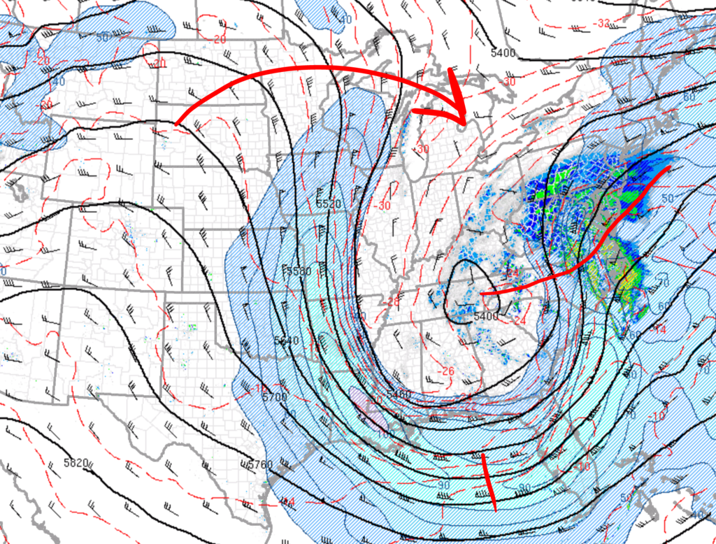
The 500mb low closed off and is heading east-northeast. The ridge downstream is preventing it from moving north - which is why we're likely to see cut-offs in the first place. The trough is neutral with heights rising well into NJ / PA. It remains to be seen whether the trough goes negative at any point during this storm. At this time I think no. The decaying ridge will flatten heights and keep the flow progressive. But the block to the north, H5 closing off early, and favorably positioned jet streaks is what will keep the low close to the coast.
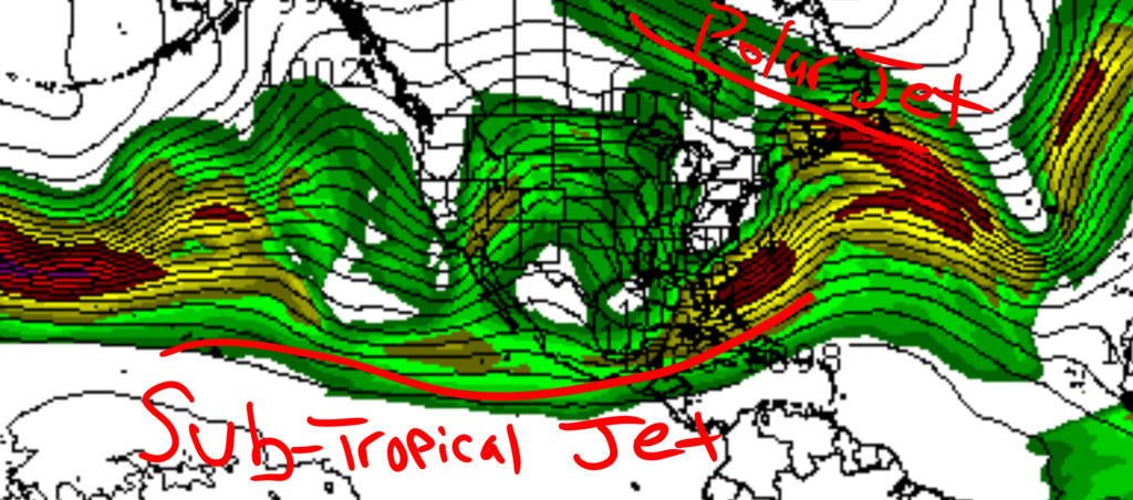
Here are 250mb winds valid 1pm tomorrow afternoon on a World map. Look at that Sub-Tropical Jet Stream! There is Pacific air feeding into this storm. There is also the northern jet phasing in with the STJ off the coast. THIS could be why some models are chasing convection on the east end of the trough.
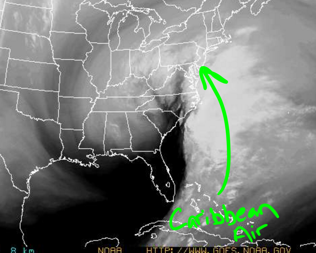
It's not just the Pacific feeding the storm. There is also Caribbean moisture streaming up the coast. This is why current radar shows thunderstorms getting into the southeast and southern Mid-Atlantic. As these thunderstorms ride into the cold air mass, that will spark snow rates to intensify. Aka thundersnow!

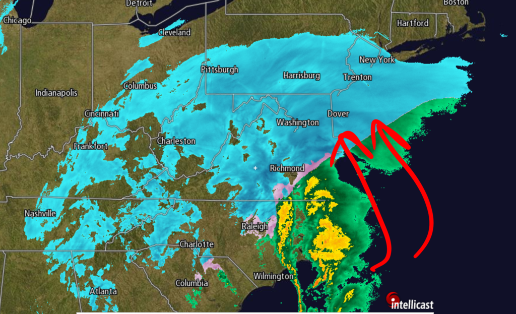
The primary low is dying over western NC and a secondary is taking over off the coast of NC. Convection is streaming N-NW and H5 heights are pointing north. This argues for the surface low to take a track right up the coast. Once the ridge to the west collapses and the H250 jet streaks shift east, that is when the surface low will begin to pull away from the coast and track east. The timing of when this happens is critical for those near the gradient. If this happens quickly, the cut-off is real and areas just south will see a historic storm. If it takes time to develop, the surface low will track north enough to bring substantial banding into HV and CT.
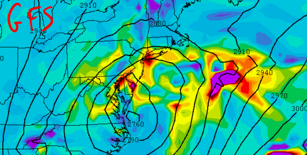
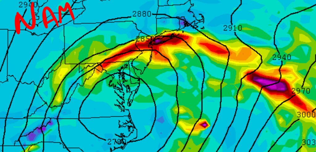
The GFS (top) is elongated with 700mb vertical velocities, or where the greatest lift will be. Meanwhile, the NAM nicely pivots H7 VV's around the H7 low. The NAM - as well as other mesoscale models - keep the surface low organized and close to the coast while Globals broaden it out. Regardless, both models show incredible lift getting into the area in the early afternoon. The CCB is likely to be very impressive with thundersnow and snow rates of 2-3" an hour.
The NAM, RGEM, HRRR, RAP show Roidzilla-criteria snow falling over PARTS of the area.
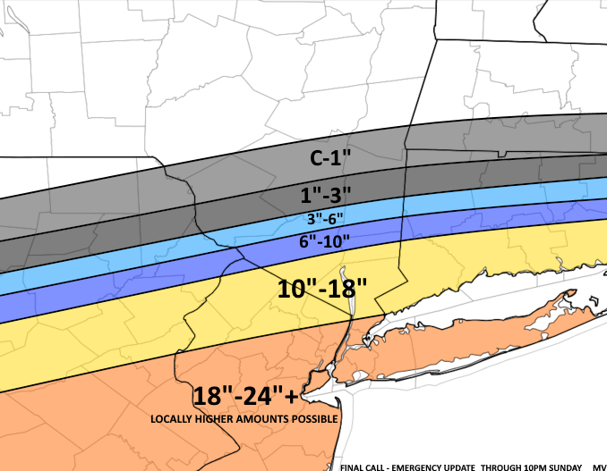
UPDATED SNOW MAP

AGAIN, this means my confidence is HIGH that the POTENTIAL for 24" is possible if you're in the purple or red shading!!

The 500mb low closed off and is heading east-northeast. The ridge downstream is preventing it from moving north - which is why we're likely to see cut-offs in the first place. The trough is neutral with heights rising well into NJ / PA. It remains to be seen whether the trough goes negative at any point during this storm. At this time I think no. The decaying ridge will flatten heights and keep the flow progressive. But the block to the north, H5 closing off early, and favorably positioned jet streaks is what will keep the low close to the coast.

Here are 250mb winds valid 1pm tomorrow afternoon on a World map. Look at that Sub-Tropical Jet Stream! There is Pacific air feeding into this storm. There is also the northern jet phasing in with the STJ off the coast. THIS could be why some models are chasing convection on the east end of the trough.

It's not just the Pacific feeding the storm. There is also Caribbean moisture streaming up the coast. This is why current radar shows thunderstorms getting into the southeast and southern Mid-Atlantic. As these thunderstorms ride into the cold air mass, that will spark snow rates to intensify. Aka thundersnow!


The primary low is dying over western NC and a secondary is taking over off the coast of NC. Convection is streaming N-NW and H5 heights are pointing north. This argues for the surface low to take a track right up the coast. Once the ridge to the west collapses and the H250 jet streaks shift east, that is when the surface low will begin to pull away from the coast and track east. The timing of when this happens is critical for those near the gradient. If this happens quickly, the cut-off is real and areas just south will see a historic storm. If it takes time to develop, the surface low will track north enough to bring substantial banding into HV and CT.


The GFS (top) is elongated with 700mb vertical velocities, or where the greatest lift will be. Meanwhile, the NAM nicely pivots H7 VV's around the H7 low. The NAM - as well as other mesoscale models - keep the surface low organized and close to the coast while Globals broaden it out. Regardless, both models show incredible lift getting into the area in the early afternoon. The CCB is likely to be very impressive with thundersnow and snow rates of 2-3" an hour.
The NAM, RGEM, HRRR, RAP show Roidzilla-criteria snow falling over PARTS of the area.
UPDATED SNOW MAP

AGAIN, this means my confidence is HIGH that the POTENTIAL for 24" is possible if you're in the purple or red shading!!
_________________
_______________________________________________________________________________________________________
CLICK HERE to view NJ Strong Snowstorm Classifications
 Re: Roidzilla Storm Mode - January 23, 2016 Updated Final Call
I updated mine a few minutes ago as well.


snow247- Pro Enthusiast

- Posts : 2417
Reputation : 0
Join date : 2014-08-27
Location : Mount Ivy, NY - Elevation 545'
 Re: Roidzilla Storm Mode - January 23, 2016 Updated Final Call
awesome write up, as always

RJB8525- Senior Enthusiast

- Posts : 1994
Reputation : 28
Join date : 2013-02-06
Age : 38
Location : Hackettstown, NJ
 Re: Roidzilla Storm Mode - January 23, 2016 Updated Final Call
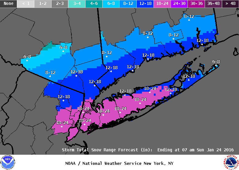
UPTON!!!!!!!!!!!!


SoulSingMG- Senior Enthusiast

- Posts : 2853
Reputation : 74
Join date : 2013-12-11
Location : Long Island City, NY
 Re: Roidzilla Storm Mode - January 23, 2016 Updated Final Call
Love it Frank! Amazing storm!
Radz- Pro Enthusiast

- Posts : 1028
Reputation : 17
Join date : 2013-01-12
Location : Cortlandt Manor NY
 Re: Roidzilla Storm Mode - January 23, 2016 Updated Final Call
MT HOLLY GOING ALL IN


RJB8525- Senior Enthusiast

- Posts : 1994
Reputation : 28
Join date : 2013-02-06
Age : 38
Location : Hackettstown, NJ
 Re: Roidzilla Storm Mode - January 23, 2016 Updated Final Call
Wow what a gradient u have frank 10 miles south of me up to 24. Hey it will b what it will I'm still stoked. Lol news 12 5 to 9 max.

jmanley32- Senior Enthusiast

- Posts : 20645
Reputation : 108
Join date : 2013-12-12
Age : 43
Location : Yonkers, NY
 Re: Roidzilla Storm Mode - January 23, 2016 Updated Final Call
UPTON just updated their snow map, 12-18 all the way up to northern Rockland/Westchester, NYC and most of LI now in 18-24!

snow247- Pro Enthusiast

- Posts : 2417
Reputation : 0
Join date : 2014-08-27
Location : Mount Ivy, NY - Elevation 545'
 Re: Roidzilla Storm Mode - January 23, 2016 Updated Final Call
the 18 to 24 nws literally ends about 3 miles north of me wow.SoulSingMG wrote:UPTON!!!!!!!!!!!!

jmanley32- Senior Enthusiast

- Posts : 20645
Reputation : 108
Join date : 2013-12-12
Age : 43
Location : Yonkers, NY
 Re: Roidzilla Storm Mode - January 23, 2016 Updated Final Call
SoulSingMG wrote:UPTON!!!!!!!!!!!!
Orange county solidly in 8-12 on that map and still only a winter storm watch.
I suppose the thinking is if that ridge in the west collapses to soon as is still very much on the table as frank has mentioned the HV is scrooed.
I will not sleep well tonight.

CPcantmeasuresnow- Wx Statistician Guru

- Posts : 7282
Reputation : 230
Join date : 2013-01-07
Age : 103
Location : Eastern Orange County, NY
 Re: Roidzilla Storm Mode - January 23, 2016 Updated Final Call
I am completely blown away. This kind of event may never happen again in our lifetime.

SoulSingMG- Senior Enthusiast

- Posts : 2853
Reputation : 74
Join date : 2013-12-11
Location : Long Island City, NY
 Re: Roidzilla Storm Mode - January 23, 2016 Updated Final Call
NEWS 12...only thing good about them is ELISA DESTEFANO...love her....don't watch them for snow totals though. Not since Joe Cioffi left.

devsman- Pro Enthusiast

- Posts : 424
Reputation : 4
Join date : 2014-01-01
Age : 48
Location : merrick, ny (south shore of Long Island)
 Re: Roidzilla Storm Mode - January 23, 2016 Updated Final Call
CPcantmeasuresnow wrote:SoulSingMG wrote:UPTON!!!!!!!!!!!!
Orange county solidly in 8-12 on that map and still only a winter storm watch.
I suppose the thinking is if that ridge in the west collapses to soon as is still very much on the table as frank has mentioned the HV is scrooed.
I will not sleep well tonight.
A lot of people are saying this could come even further north.

snow247- Pro Enthusiast

- Posts : 2417
Reputation : 0
Join date : 2014-08-27
Location : Mount Ivy, NY - Elevation 545'
 Re: Roidzilla Storm Mode - January 23, 2016 Updated Final Call
Omg news12 is terrible new update 5 to 9 inches. I can't believe no state of emergency.

jmanley32- Senior Enthusiast

- Posts : 20645
Reputation : 108
Join date : 2013-12-12
Age : 43
Location : Yonkers, NY
 Re: Roidzilla Storm Mode - January 23, 2016 Updated Final Call
snow247 wrote:CPcantmeasuresnow wrote:SoulSingMG wrote:UPTON!!!!!!!!!!!!
Orange county solidly in 8-12 on that map and still only a winter storm watch.
I suppose the thinking is if that ridge in the west collapses to soon as is still very much on the table as frank has mentioned the HV is scrooed.
I will not sleep well tonight.
A lot of people are saying this could come even further north.
At this rate, WHY STOP NOW???? lmfao GO BIG OR GO HOME BABY!!!! WOOOOOOOOOOOOOOOOOOO!!!!!!!!!!!!!!!
rb924119- Meteorologist

- Posts : 7102
Reputation : 195
Join date : 2013-02-06
Age : 32
Location : Greentown, Pa
 Re: Roidzilla Storm Mode - January 23, 2016 Updated Final Call
Lee Goldberg is now going for 12-18. He did mention it may not be high enough.

nutleyblizzard- Senior Enthusiast

- Posts : 1963
Reputation : 41
Join date : 2014-01-30
Age : 58
Location : Nutley, new jersey
 Re: Roidzilla Storm Mode - January 23, 2016 Updated Final Call
jman blizzard warning for mt Vernon just came over my phone!!!!!!!!

algae888- Advanced Forecaster

- Posts : 5311
Reputation : 46
Join date : 2013-02-05
Age : 62
Location : mt. vernon, new york
 Re: Roidzilla Storm Mode - January 23, 2016 Updated Final Call
give me 20 miles I to the 18 to 24 I'll b even happier. Dr k in hand this is the best.snow247 wrote:CPcantmeasuresnow wrote:SoulSingMG wrote:UPTON!!!!!!!!!!!!
Orange county solidly in 8-12 on that map and still only a winter storm watch.
I suppose the thinking is if that ridge in the west collapses to soon as is still very much on the table as frank has mentioned the HV is scrooed.
I will not sleep well tonight.
A lot of people are saying this could come even further north.

jmanley32- Senior Enthusiast

- Posts : 20645
Reputation : 108
Join date : 2013-12-12
Age : 43
Location : Yonkers, NY
 Re: Roidzilla Storm Mode - January 23, 2016 Updated Final Call
nutleyblizzard wrote:Lee Goldberg is now going for 12-18. He did mention it may not be high enough.
YUP! He's going to look at new data and come back with updates locally 20+ he put up

RJB8525- Senior Enthusiast

- Posts : 1994
Reputation : 28
Join date : 2013-02-06
Age : 38
Location : Hackettstown, NJ
 Re: Roidzilla Storm Mode - January 23, 2016 Updated Final Call
Lee upped his totals to 12-18 locally 20+ for NYC LI

gigs68- Posts : 142
Reputation : 3
Join date : 2013-01-16
Location : Commack, NY (NW Suffolk)
 Re: Roidzilla Storm Mode - January 23, 2016 Updated Final Call
we in same county wth? Weird not shown on nws map. What carrier do u have? T-Mobile not gr8. That's what I have.algae888 wrote:jman blizzard warning for mt Vernon just came over my phone!!!!!!!!
Last edited by jmanley32 on Fri Jan 22, 2016 11:08 pm; edited 1 time in total

jmanley32- Senior Enthusiast

- Posts : 20645
Reputation : 108
Join date : 2013-12-12
Age : 43
Location : Yonkers, NY
 Re: Roidzilla Storm Mode - January 23, 2016 Updated Final Call
A solid 3" in Bayville Ocean County alreadly. Now dealing with mixed precip though....

nujerzeedevil- Posts : 121
Reputation : 14
Join date : 2013-12-30
Location : Bayville, NJ
 Re: Roidzilla Storm Mode - January 23, 2016 Updated Final Call
Orange = blizzard warning


_________________
_______________________________________________________________________________________________________
CLICK HERE to view NJ Strong Snowstorm Classifications
 Re: Roidzilla Storm Mode - January 23, 2016 Updated Final Call
I called this back hours ago 18" - 24" WOOOOO HOOOOOO

Joe Snow- Pro Enthusiast

- Posts : 933
Reputation : 7
Join date : 2014-02-12
Age : 62
Location : Sanford Florida, Fmrly Kings Park, NY
 Re: Roidzilla Storm Mode - January 23, 2016 Updated Final Call
Al it changed on map. Still coming through. Not in txt yet. Here we go!

jmanley32- Senior Enthusiast

- Posts : 20645
Reputation : 108
Join date : 2013-12-12
Age : 43
Location : Yonkers, NY
Page 1 of 6 • 1, 2, 3, 4, 5, 6 
Permissions in this forum:
You cannot reply to topics in this forum
 Home
Home