Long Range Thread 12.0
+30
StatenWx
Dunnzoo
weatherwatchermom
Quietace
dkodgis
mwilli5783
jrollins628
devsman
skinsfan1177
billg315
jmanley32
Snow88
chief7
Dtone
Isotherm
sroc4
docstox12
CPcantmeasuresnow
frank 638
track17
NjWeatherGuy
HectorO
SNOW MAN
rb924119
Math23x7
algae888
snow247
amugs
nutleyblizzard
Frank_Wx
34 posters
Page 2 of 40
Page 2 of 40 •  1, 2, 3 ... 21 ... 40
 Re: Long Range Thread 12.0
Frank_Wx wrote:Decided to check out SSTs in the Atlantic, but couldn't help but notice the abnormal warmth in the north Pacific. It looks like the "blob" is back. If this feature is here after Christmas, we'll be on our way to see a below average temperature season.
Frank - I love that Blob
amugs- Advanced Forecaster - Mod

- Posts : 15156
Join date : 2013-01-07
 Re: Long Range Thread 12.0
Frank_Wx wrote:Decided to check out SSTs in the Atlantic, but couldn't help but notice the abnormal warmth in the north Pacific. It looks like the "blob" is back. If this feature is here after Christmas, we'll be on our way to see a below average temperature season.
Amazing how quick it flips, remember seeing that eastern pacific water dark red/beige colored on that map seemingly not too long ago.
NjWeatherGuy- Advanced Forecaster

- Posts : 4100
Join date : 2013-01-06
 Re: Long Range Thread 12.0
Still warm off our coast tho, which may fuel some stronger systems
NjWeatherGuy- Advanced Forecaster

- Posts : 4100
Reputation : 28
Join date : 2013-01-06
Location : Belle Mead, NJ
 Re: Long Range Thread 12.0
A +PDO is good, but what we really need which has been primarily absent the past several winters is a -NAO. Lately its been present in the spring and summer. As most of you know, Atlantic blocking slows the pattern down where winter storms can be much more severe due to the slower movement of the low pressure and high pressure stays in an optimum position to assure cold arctic air.

nutleyblizzard- Senior Enthusiast

- Posts : 1964
Reputation : 41
Join date : 2014-01-30
Age : 58
Location : Nutley, new jersey
 Re: Long Range Thread 12.0
Nino1+2 Nino3 Nino34 Nino4
10AUG2016 21.0 0.1 24.5-0.7 26.3-0.6 28.6-0.1
17AUG2016 21.1 0.5 24.5-0.5 26.3-0.5 28.7 0.0
Latest values:
Nino 1.2: +0.5 (+0.4)
Nino 3: -0.5 (+0.2)
Nino 3.4: -0.5 (+0.1)
Nino 4: 0.0 (+0.1)
Modoki Nina setting up
10AUG2016 21.0 0.1 24.5-0.7 26.3-0.6 28.6-0.1
17AUG2016 21.1 0.5 24.5-0.5 26.3-0.5 28.7 0.0
Latest values:
Nino 1.2: +0.5 (+0.4)
Nino 3: -0.5 (+0.2)
Nino 3.4: -0.5 (+0.1)
Nino 4: 0.0 (+0.1)
Modoki Nina setting up
_________________
Mugs
AKA:King: Snow Weenie
Self Proclaimed
WINTER 2014-15 : 55.12" +.02 for 6 coatings (avg. 35")
WINTER 2015-16 Total - 29.8" (Avg 35")
WINTER 2016-17 : 39.5" so far

amugs- Advanced Forecaster - Mod

- Posts : 15156
Reputation : 213
Join date : 2013-01-07
Age : 54
Location : Hillsdale,NJ
 Re: Long Range Thread 12.0
What do those numbers mean? Is it good or bad?
track17- Posts : 454
Reputation : 4
Join date : 2016-01-09
 Re: Long Range Thread 12.0
amugs wrote:Frank_Wx wrote:Decided to check out SSTs in the Atlantic, but couldn't help but notice the abnormal warmth in the north Pacific. It looks like the "blob" is back. If this feature is here after Christmas, we'll be on our way to see a below average temperature season.
Frank - I love that Blob


!!!
Me too. The only blob I'll love in life.
nutleyblizzard wrote:A +PDO is good, but what we really need which has been primarily absent the past several winters is a -NAO. Lately its been present in the spring and summer. As most of you know, Atlantic blocking slows the pattern down where winter storms can be much more severe due to the slower movement of the low pressure and high pressure stays in an optimum position to assure cold arctic air.
I'm not sure anyone can forecast the NAO. So much research has been done to correlate sea level pressure in the northern Pacific with the NAO state, and it's failed. The AMO doesn't seem to show a correlation either. I think it's a work in progress and a huge wildcard, much like sudden stratospheric warming.
track17 wrote:What do those numbers mean? Is it good or bad?
So values between -0.5 and +0.5 is considered neutral ENSO. Anything above .5 over 3 consecutive months is El Nino and anything less than -0.5 is LA Nina. Statistical models and current SSTs suggest we're on our way to a weak LA Nina.
_________________
_______________________________________________________________________________________________________
CLICK HERE to view NJ Strong Snowstorm Classifications
 Re: Long Range Thread 12.0
I keep forgetting if we are having a weak LA Nina does this mean we will have a good winter or bad one .
just curious
just curious
frank 638- Senior Enthusiast

- Posts : 2882
Reputation : 37
Join date : 2016-01-01
Age : 41
Location : bronx ny
 Re: Long Range Thread 12.0
SNOW MAN wrote:rb924119 wrote:I love how you guys are the only crew that I know that are already excited for winter ahahaha AND I LOVE IT!!!!
You mean there are other seasons besides Winter. Interesting.
Wow a Snow Man appearance in August? This is rare. Possibly a sign like when squirrels start gathering a sh!t load of nuts early in fall you can count on an early and prolonged winter. Let's hope it plays out that way.
Sick of summer but loving my Yankees.

CPcantmeasuresnow- Wx Statistician Guru

- Posts : 7288
Reputation : 230
Join date : 2013-01-07
Age : 103
Location : Eastern Orange County, NY
 Re: Long Range Thread 12.0
CPcantmeasuresnow wrote:SNOW MAN wrote:rb924119 wrote:I love how you guys are the only crew that I know that are already excited for winter ahahaha AND I LOVE IT!!!!
You mean there are other seasons besides Winter. Interesting.
Wow a Snow Man appearance in August? This is rare. Possibly a sign like when squirrels start gathering a sh!t load of nuts early in fall you can count on an early and prolonged winter. Let's hope it plays out that way.
Sick of summer but loving my Yankees.
Wait a minute, its not time for you to be out of summer hibernation yet!! You are the only mammal CP who hibernates in the summer and comes out of it in mid October!! Back to your log on OTI, not ready for Prime Time yet,LOL.And my brain dead status thes edays... did not even realize SNOWMAN posted!!!
And forget about those acorns lest you incur Mako's wrath,LOL
Getting there guys, getting there!!!
All joking aside its great to see all of the old winter crew on this thread.Its been a long time.

docstox12- Wx Statistician Guru

- Posts : 8617
Reputation : 222
Join date : 2013-01-07
Age : 74
Location : Monroe NY
 Re: Long Range Thread 12.0
The 48 degree morning we had earlier in the week woke me from hibernation Doc, the weather these next several days may put me back to sleep.
Was going through the old OTI stuff and my compliments on an incredible job this year closing down the Island. October 1 will be here before you know it.
Was going through the old OTI stuff and my compliments on an incredible job this year closing down the Island. October 1 will be here before you know it.

CPcantmeasuresnow- Wx Statistician Guru

- Posts : 7288
Reputation : 230
Join date : 2013-01-07
Age : 103
Location : Eastern Orange County, NY
 Re: Long Range Thread 12.0
CP,my Buddy, yes ,that cool crisp morning the other day was a great harbinger of what is to come.You know as well as I that mid to late August around these parts features just such mornings.Looking forward to the upcoming tracking season ,although this December seems to be trending warm (UGH).Anyway, good to see you, SNOWMAN, and the rest of the winter crew are all ok and ready for action!
Thanks on OTI, just got back from an inspection tour and will post on the OTI thread shortly the results.
And, yes, congrats on those young Yankee players!! The team is heading in the right direction, away from aging wrecks towards young talent!! Think you guys still have a shot at the playoffs but you are in the toughest division in baseball.Good Luck........DOC

docstox12- Wx Statistician Guru

- Posts : 8617
Reputation : 222
Join date : 2013-01-07
Age : 74
Location : Monroe NY
 Re: Long Range Thread 12.0
Now I may have seen it all - SNOWY and CP come out of summer hibernation to grace us witheir presence (presents to be real here). Looking forward to the Fantastic Four making a run again this year in winter time, bringing back the ol' gang.
Modoki Nina Setting up here - will makes things interesting for sure come winter
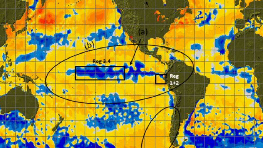
Modoki Nina Setting up here - will makes things interesting for sure come winter

_________________
Mugs
AKA:King: Snow Weenie
Self Proclaimed
WINTER 2014-15 : 55.12" +.02 for 6 coatings (avg. 35")
WINTER 2015-16 Total - 29.8" (Avg 35")
WINTER 2016-17 : 39.5" so far

amugs- Advanced Forecaster - Mod

- Posts : 15156
Reputation : 213
Join date : 2013-01-07
Age : 54
Location : Hillsdale,NJ
 Re: Long Range Thread 12.0
Some of teh analog years that are being used for this upcoming winter season, weak la nina could mean and colder December - not 70* on xmas maybe 50 then?? HAHAHA

I just read a write up from a met student in Mass who discusses the "Delayed Oscillation" effect which is what from the readings we will be and are experiencing. Newtons Third Law applies to all forces occurring on the spaceship we call Earth (I want you to take 10 seconds and think about that one - we live on a huge spaceship ?!!) So with this Law then we should be experiencing in 2017 -18 a moderate Nina BUT it depends on other factors 0- the kink in the Law for meteorology - Rosby and Kelvin Waves/Winds. Here is the link if you have a few minutes to read.
http://easternmassweather.blogspot.com/
One met saying he is fairly optimistic on a normal to possibly bn December Temperature regime this year with present info, We shall se
_________________
Mugs
AKA:King: Snow Weenie
Self Proclaimed
WINTER 2014-15 : 55.12" +.02 for 6 coatings (avg. 35")
WINTER 2015-16 Total - 29.8" (Avg 35")
WINTER 2016-17 : 39.5" so far

amugs- Advanced Forecaster - Mod

- Posts : 15156
Reputation : 213
Join date : 2013-01-07
Age : 54
Location : Hillsdale,NJ
 Re: Long Range Thread 12.0
Mugs I think one thing we can be sure of that this year's Nina will not give us the same results as a typical nina similar to last year's Super El Nino. For example California did not get the drenching rains that they usually get with an El Nino. Also Central based Nina's or modiki's usually lead to a positive Nao. Maybe that will be different this year if Nina behaves differently. I believe the main reason is that the Pacific is still very warm overall. The Pacific doesn't look like a typical nina at this point. very warm Waters to the North and South of the tropical Pacific. Also if anyone has information on the stratosphere I'm hearing that it's not as cold as it was last year at this time which hindered and delayed the sswe last year. Scott snowman and cp welcome back always look forward to reading your posts

algae888- Advanced Forecaster

- Posts : 5311
Reputation : 46
Join date : 2013-02-05
Age : 62
Location : mt. vernon, new york
 Re: Long Range Thread 12.0
algae888 wrote:Mugs I think one thing we can be sure of that this year's Nina will not give us the same results as a typical nina similar to last year's Super El Nino. For example California did not get the drenching rains that they usually get with an El Nino. Also Central based Nina's or modiki's usually lead to a positive Nao. Maybe that will be different this year if Nina behaves differently. I believe the main reason is that the Pacific is still very warm overall. The Pacific doesn't look like a typical nina at this point. very warm Waters to the North and South of the tropical Pacific. Also if anyone has information on the stratosphere I'm hearing that it's not as cold as it was last year at this time which hindered and delayed the sswe last year. Scott snowman and cp welcome back always look forward to reading your posts
Weak la nina, or near neutral ENSO predicted. Typically yields the best results for below avg. temps and above avg. precipitation (snow) in the east.

NjWeatherGuy- Advanced Forecaster

- Posts : 4100
Reputation : 28
Join date : 2013-01-06
Location : Belle Mead, NJ
 Re: Long Range Thread 12.0
Assuming a weak la nina or near neutral to occur, I have gathered the winters from 1950 onward that may be similar to what is projected to unfold. Of course, each winter has more factors at play and no two are exactly alike, so who knows. Anyway:
1959-1960, 1961-1962, 1966-1967, 1967-1968, 1980-1981, 1995-1996, 1996-1997, 2001-2002, 2005-2006, 2008-2009, 2011-2012, 2013-2014
From my stronger memory around the mid 2000s onward, I can remember some of these winters being productive for snow and cold for our area, however some were meh. Anyone older with better memory of those older winters feel free to chime in.

NjWeatherGuy- Advanced Forecaster

- Posts : 4100
Reputation : 28
Join date : 2013-01-06
Location : Belle Mead, NJ
 Re: Long Range Thread 12.0
I don't agree with the Old Farmer's Almanac saying we will have a mild start to winter. Typically weak LaNina's gives our region colder than normal conditions. One other important detail is the state of the PDO. Normally its in a negative state during a LaNina. This winter however looks like it could very well be in a positive one. That's pretty rare for the two to coincide like that. If that comes to fruition we could see well below temp departures for the winter. Frank any thoughts?

nutleyblizzard- Senior Enthusiast

- Posts : 1964
Reputation : 41
Join date : 2014-01-30
Age : 58
Location : Nutley, new jersey
 Re: Long Range Thread 12.0
NjWeatherGuy wrote:Assuming a weak la nina or near neutral to occur, I have gathered the winters from 1950 onward that may be similar to what is projected to unfold. Of course, each winter has more factors at play and no two are exactly alike, so who knows. Anyway:
1959-1960, 1961-1962, 1966-1967, 1967-1968, 1980-1981, 1995-1996, 1996-1997, 2001-2002, 2005-2006, 2008-2009, 2011-2012, 2013-2014
From my stronger memory around the mid 2000s onward, I can remember some of these winters being productive for snow and cold for our area, however some were meh. Anyone older with better memory of those older winters feel free to chime in.
December 1959 was snowy.March 1960 had a 17 inch snowstorm. 61-62 was meh, a big disappointment after 1960-1961.Jan or Feb 1967 had a nice 20 inch snowstorm.1067-1968 was meh.1980-1981 meh.Of course the KING was 1995-1996

docstox12- Wx Statistician Guru

- Posts : 8617
Reputation : 222
Join date : 2013-01-07
Age : 74
Location : Monroe NY
 Re: Long Range Thread 12.0
docstox12 wrote:NjWeatherGuy wrote:Assuming a weak la nina or near neutral to occur, I have gathered the winters from 1950 onward that may be similar to what is projected to unfold. Of course, each winter has more factors at play and no two are exactly alike, so who knows. Anyway:
1959-1960, 1961-1962, 1966-1967, 1967-1968, 1980-1981, 1995-1996, 1996-1997, 2001-2002, 2005-2006, 2008-2009, 2011-2012, 2013-2014
From my stronger memory around the mid 2000s onward, I can remember some of these winters being productive for snow and cold for our area, however some were meh. Anyone older with better memory of those older winters feel free to chime in.
December 1959 was snowy.March 1960 had a 17 inch snowstorm. 61-62 was meh, a big disappointment after 1960-1961.Jan or Feb 1967 had a nice 20 inch snowstorm.1067-1968 was meh.1980-1981 meh.Of course the KING was 1995-1996
WINTER OF 96!!
Guest- Guest
 Re: Long Range Thread 12.0
algae888 wrote:Mugs I think one thing we can be sure of that this year's Nina will not give us the same results as a typical nina similar to last year's Super El Nino. For example California did not get the drenching rains that they usually get with an El Nino. Also Central based Nina's or modiki's usually lead to a positive Nao. Maybe that will be different this year if Nina behaves differently. I believe the main reason is that the Pacific is still very warm overall. The Pacific doesn't look like a typical nina at this point. very warm Waters to the North and South of the tropical Pacific. Also if anyone has information on the stratosphere I'm hearing that it's not as cold as it was last year at this time which hindered and delayed the sswe last year. Scott snowman and cp welcome back always look forward to reading your posts
Hey Al. Great to be back. I did a little investigating for you regarding the Stratosphere. Lets discuss this graphic first.

In the graphs labeled B and C notice the little arrows on the Left. This is showing that pretty much from November through mid Jan the Strat temps at both 10 and 30hpa were well below normal relative the the 30yr mean. The graph labeled "A" you can see that last winter we had three Stratospheric warming events; if you follow the black lines down from the ovals you can see they are labeled 2, 3, and 4 and occurred late Jan, early-mid Feb and ealy March respectively, which BTW Isotherm accurately predicted. What was not easily predicted; however, was the lack of response below the strat in the troposphere. The black line labled 1, if you follow it back up through the graphic, is showing that right before the first warming event the strat temps took a dip well below the 30yr avg, so our starting point for the three warming events was the bottom of a huge mountain to overcome. I stated last year during some of our Strat convos that because the earth is constantly trying to maintain balance and order in an otherwise chaotic system, my theory as to why the strat was as cold as it was was in part because the entire tropical pacific and Indian ocean was so far above normal SST that some way somehow, and I cant prove this in any way, the exceptionally anomalously warm equator was balanced out by the exceptionally cold stratosphere. Moving on
Look back at the graph above labled A and the first warming event. Now look at graphs B and C and you will see that there was a fairly significant warming event; however, relative to the 30yr mean temps only briefly went slightly above the avg. temp. This means that although a warming event took place it was weak against the 30yr mean so really didn't translate into much for us down in the troposphere. The second event was much larger event and went much higher relative to avg, but you can see right after the event temps dipped back down well below the avg mean; again not translating into much in the way of sustained effects for us in the troposphere. It wasn't until the third event occurred in early march that you can see that the temps actually remained above normal but by then winter was pretty much wrapping up and nothing came of it. Lets look at this another way.
Below are 2 graphs basically showing the same thing as above. First graph is actual temps and the second is the temp anomalies relative to avg.
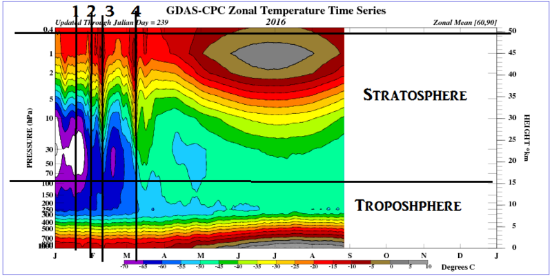
1, 2, 3, and 4 on the graph above correlate with 1, 2, 3, and 4 on the first graph I showed above. You can see the cold temps at 1, and the three warming events (2, 3, & 4) indicated by the warm colors. You can see once again it isn't until after the third event in early march that the warm colors persist.
Now lets look at the map below. This is the temp anomaly map. The oval labeled 1 here is showing the temp anomalies throughout the entire column of the strat is between -8 and -12 *C below normal right before the first warming event. The oval labled 2 is showing how despite after the 2nd more significant warming event in early to mid Feb, warm colors in between 1 & 2, the temps came right back down to below normal again. And oval labled 3 shows the sustained above normal temps throughout the strat column after the third event in March.
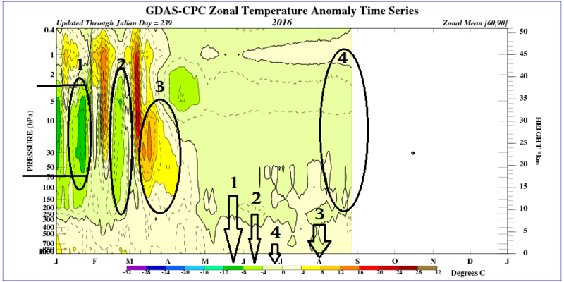
Now finally to address the question about where the stratospheric temps now are relative to this time last year. Looking at the anomaly map immedietly above the Oval labled 4 is the current temps. You can see the majority of the stratospheric column is at about 0--4*C below normal relative to avg with the exception of the very upper level of the strat which looks to be around 0--4*C above normal. The graphic below is 2015 temp anomalies. The oval labeled 4 is the same time last year as it is now. You can clearly see that the current stratospheric temps are pretty much the same now as they were last year at all levels. What we are going to have to watch going forward is the area below I have labeled 5. If you quickly look back at the first graphic I posted at the top of this write up you will notice the area I have indicated with all of the little arrows on the left, basically from Nov 1st through Jan 1st is where the stratospheric temps begin to really nose dive below avg. It is shown very clearly as well on the graphic below in the area labeled 5.

So moving forward Novemeber to Jan is the time to watch the strat if we are going to compare to last year. IMHO if we did not have such a strong Nino and the strat temps just before the first and second warming events were at or around avg, last winter (particularly second half of Feb and first 1-2weeks of March) could have been epic. Looking at this upcoming winter we have no doubt that the Nino is long gone; instead we have a La Nada to weak La Nina (although not set in stone), setting up. We also have "The Blob", otherwise known as a + PDO setting up in the NE Pac as well (also not set in stone). So should we have a true SSWE, (sudden stratospheric warming event) take place between Dec-Mid Feb we could very well have an epic winter this year. Preliminarily this winter season is setting up nicely, but there is still a VERY long way to go and many other factors to watch.
_________________
"In weather and in life, there's no winning and losing; there's only winning and learning."
WINTER 2012/2013 TOTALS 43.65"WINTER 2017/2018 TOTALS 62.85" WINTER 2022/2023 TOTALS 4.9"
WINTER 2013/2014 TOTALS 64.85"WINTER 2018/2019 TOTALS 14.25" WINTER 2023/2024 TOTALS 13.1"
WINTER 2014/2015 TOTALS 71.20"WINTER 2019/2020 TOTALS 6.35" WINTER 2024/2025 TOTALS 0.00
WINTER 2015/2016 TOTALS 35.00"WINTER 2020/2021 TOTALS 37.75"
WINTER 2016/2017 TOTALS 42.25"WINTER 2021/2022 TOTALS 31.65"

sroc4- Admin

- Posts : 8458
Reputation : 302
Join date : 2013-01-07
Location : Wading River, LI
 Re: Long Range Thread 12.0
Thanks Scott great write up. Well assuming your correllation between the trop and strat are correct, we should see the strat warmer to start this winter as the pacific will be much cooler with the shift from super nino to nina.

algae888- Advanced Forecaster

- Posts : 5311
Reputation : 46
Join date : 2013-02-05
Age : 62
Location : mt. vernon, new york
 Re: Long Range Thread 12.0
Look what I just read through. Now I am definitely ready for winter. Man what a storm that was.
https://www.njstrongweatherforum.com/t648-january-23-2016-roidzilla-storm-in-review#88763
https://www.njstrongweatherforum.com/t648-january-23-2016-roidzilla-storm-in-review#88763
_________________
_______________________________________________________________________________________________________
CLICK HERE to view NJ Strong Snowstorm Classifications
 Re: Long Range Thread 12.0
Frank_Wx wrote:Look what I just read through. Now I am definitely ready for winter. Man what a storm that was.
https://www.njstrongweatherforum.com/t648-january-23-2016-roidzilla-storm-in-review#88763
UGH, this does nothing for me up in the HV, only 10 inches with the usual S and E bias of recent years.Some of our posters got only and inch or two further north of me.Reading this just makes me glad that eventually I'll be wintering in Florida while everybody S and E gets the big snowstorms,LOL.

docstox12- Wx Statistician Guru

- Posts : 8617
Reputation : 222
Join date : 2013-01-07
Age : 74
Location : Monroe NY
 Re: Long Range Thread 12.0
docstox12 wrote:Frank_Wx wrote:Look what I just read through. Now I am definitely ready for winter. Man what a storm that was.
https://www.njstrongweatherforum.com/t648-january-23-2016-roidzilla-storm-in-review#88763
UGH, this does nothing for me up in the HV, only 10 inches with the usual S and E bias of recent years.Some of our posters got only and inch or two further north of me.Reading this just makes me glad that eventually I'll be wintering in Florida while everybody S and E gets the big snowstorms,LOL.
Eventually as in never?
We can't lose you, Doc.
_________________
_______________________________________________________________________________________________________
CLICK HERE to view NJ Strong Snowstorm Classifications
 Re: Long Range Thread 12.0
Frank, there are only two reasons I would leave your wonderful site.One...you shut it down. Two....I drop dead,lol.AND I plan on living to 100 so you poor souls will have to contend with me for a LONG TIME,LOL.Hey, the Florida bit is my lady in life's idea and you know I always get the last word in an argument with her!!.....YES DEAR,LOL.Anyway, you would have a reporter in Florida during those times.
I'm very excited now to see the old crew assembling, the days getting shorter and the kids about to go back.WINTER is the reason we all come back when the strom tracking excitement begins.
I'm very excited now to see the old crew assembling, the days getting shorter and the kids about to go back.WINTER is the reason we all come back when the strom tracking excitement begins.

docstox12- Wx Statistician Guru

- Posts : 8617
Reputation : 222
Join date : 2013-01-07
Age : 74
Location : Monroe NY
 Re: Long Range Thread 12.0
love to see the blues on the map as we head towards fall. football kids back in school shorter days pennant race baseball. best time of year!


algae888- Advanced Forecaster

- Posts : 5311
Reputation : 46
Join date : 2013-02-05
Age : 62
Location : mt. vernon, new york
Page 2 of 40 •  1, 2, 3 ... 21 ... 40
Page 2 of 40
Permissions in this forum:
You cannot reply to topics in this forum
 Home
Home