Long Range Thread 16.0
+44
snowday111
HectorO
Grselig
essexcountypete
Snow88
mwilli5783
WeatherBob
NjWeatherGuy
Dunnzoo
jake732
aiannone
crippo84
bobjohnsonforthehall
Scullybutcher
algae888
dsix85
dkodgis
sroc4
emokid51783
Math23x7
Sanchize06
docstox12
billg315
oldtimer
CPcantmeasuresnow
skinsfan1177
Quietace
SENJsnowman
lglickman1
hyde345
MattyICE
Carter bk
RJB8525
jimv45
amugs
GreyBeard
weatherwatchermom
SoulSingMG
nutleyblizzard
mikeypizano
rb924119
frank 638
jmanley32
Frank_Wx
48 posters
Page 39 of 40
Page 39 of 40 •  1 ... 21 ... 38, 39, 40
 Re: Long Range Thread 16.0
Ill tell you what. With how fast the strat will change over the next 7days, and how linked the strat and toposphere are with each other with this SSWE occurring once the models figure out how it will affect the atmosphere do not be surprised to see DRASTIC flipping in the modeling over the next few days. Flipping for the better. Ray in his frustrated post earlier eluded to this as well...lol
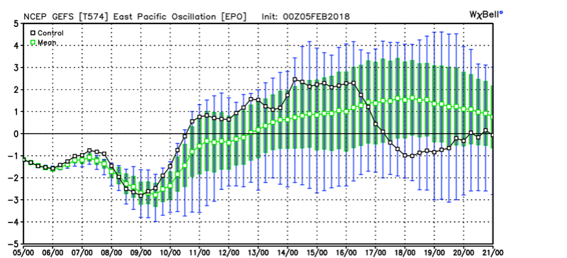
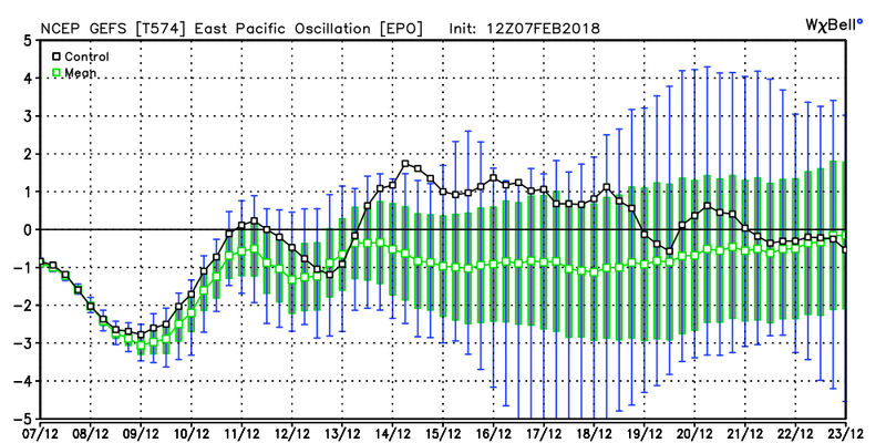
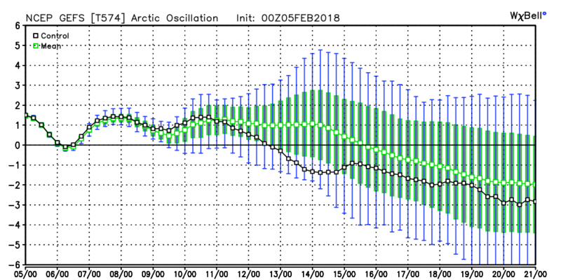
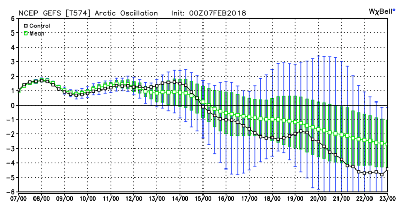
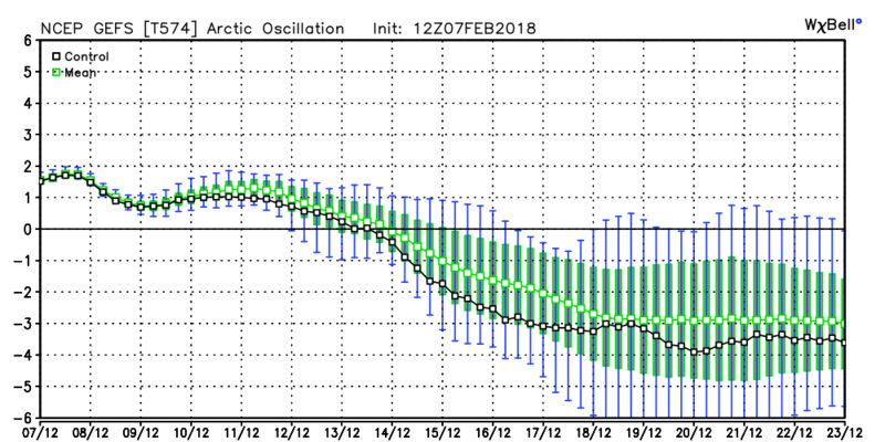
I mean look at the teleconnections on the GEFS and how literally they are doing an about face on todays 12z. Now keep in mind this is nothing more than a graph and its the first run, but by the 16th or so if the GEFS are correct we could be staring down the barrel of a -EPO/-AO/-NAO blocking pattern setting up. We have to keep an eye on the modeling because its going to change.
EPO 00z Feb 5th, 00z Feb 7th, and 12z Feb 12th

AO Same dates
NAO same dates:
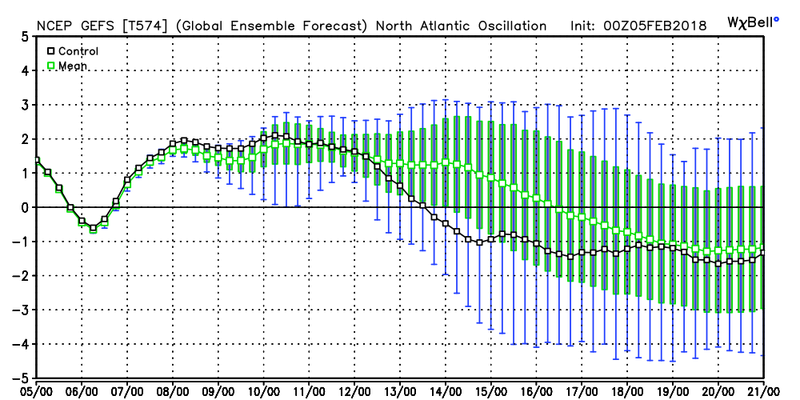
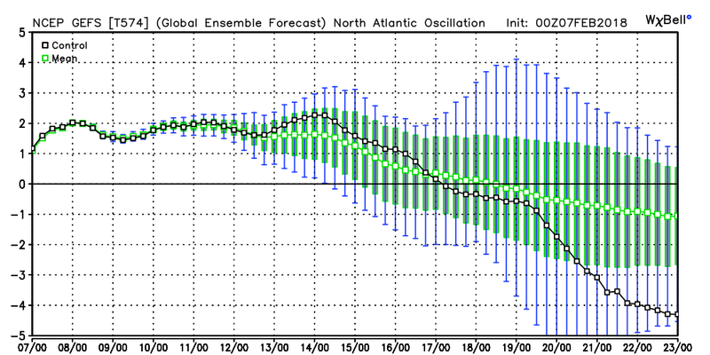
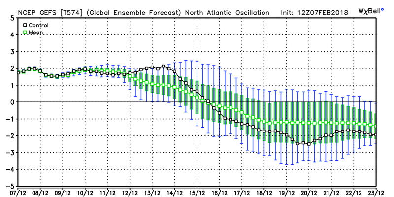
I mean look at the teleconnections on the GEFS and how literally they are doing an about face on todays 12z. Now keep in mind this is nothing more than a graph and its the first run, but by the 16th or so if the GEFS are correct we could be staring down the barrel of a -EPO/-AO/-NAO blocking pattern setting up. We have to keep an eye on the modeling because its going to change.
EPO 00z Feb 5th, 00z Feb 7th, and 12z Feb 12th


AO Same dates


NAO same dates:


sroc4- Admin

- Posts : 8459
Join date : 2013-01-07
 Re: Long Range Thread 16.0
Talk to me when we have this current radar and temps in the 20s north of my black line


Guest- Guest
 Re: Long Range Thread 16.0
syosnow94 wrote:Talk to me when we have this current radar and temps in the 20s north of my black line
There is something mighty fishy about that Rain Snow Line James.
_________________
"In weather and in life, there's no winning and losing; there's only winning and learning."
WINTER 2012/2013 TOTALS 43.65"WINTER 2017/2018 TOTALS 62.85" WINTER 2022/2023 TOTALS 4.9"
WINTER 2013/2014 TOTALS 64.85"WINTER 2018/2019 TOTALS 14.25" WINTER 2023/2024 TOTALS 13.1"
WINTER 2014/2015 TOTALS 71.20"WINTER 2019/2020 TOTALS 6.35" WINTER 2024/2025 TOTALS 0.00
WINTER 2015/2016 TOTALS 35.00"WINTER 2020/2021 TOTALS 37.75"
WINTER 2016/2017 TOTALS 42.25"WINTER 2021/2022 TOTALS 31.65"

sroc4- Admin

- Posts : 8459
Reputation : 302
Join date : 2013-01-07
Location : Wading River, LI
 Re: Long Range Thread 16.0
sroc4 wrote:syosnow94 wrote:Talk to me when we have this current radar and temps in the 20s north of my black line
There is something mighty fishy about that Rain Snow Line James.

_________________
Janet
Snowfall winter of 2023-2024 17.5"
Snowfall winter of 2022-2023 6.0"
Snowfall winter of 2021-2022 17.6" 1" sleet 2/25/22
Snowfall winter of 2020-2021 51.1"
Snowfall winter of 2019-2020 8.5"
Snowfall winter of 2018-2019 25.1"
Snowfall winter of 2017-2018 51.9"
Snowfall winter of 2016-2017 45.6"
Snowfall winter of 2015-2016 29.5"
Snowfall winter of 2014-2015 50.55"
Snowfall winter of 2013-2014 66.5"
Dunnzoo- Senior Enthusiast - Mod

- Posts : 4938
Reputation : 68
Join date : 2013-01-11
Age : 62
Location : Westwood, NJ
 Re: Long Range Thread 16.0
sroc4 wrote:amugs wrote:Earthlight and Isotherm harping on blocking and SSW split -
Way too much focus on actual numbers, heights, temps, etc on ensembles. Focus should be on the Kara/Barents Sea...where the EPS are beginning to signal major high latitude blocking in wake of the SSW...
Take a look at the 12z GEFS too. Really starting to look nice. Dare I say it....storm signal for the 16th-17th(+/- a day) time frame? Could it be enough to dig a northern s/w into the pattern more so than what we've seen? Preliminary general idea. That is all.
Scott,
As the models catch onto this massive perturbation in the PAC and PV we should some some nice solutions as they move closer to this in time. A huge MJO wave, massive SOI crash and obliteration of teh PV is causing the models to go batty
_________________
Mugs
AKA:King: Snow Weenie
Self Proclaimed
WINTER 2014-15 : 55.12" +.02 for 6 coatings (avg. 35")
WINTER 2015-16 Total - 29.8" (Avg 35")
WINTER 2016-17 : 39.5" so far

amugs- Advanced Forecaster - Mod

- Posts : 15157
Reputation : 213
Join date : 2013-01-07
Age : 54
Location : Hillsdale,NJ
 Re: Long Range Thread 16.0
Scott you are a Genius with tah call - EURO says hello for the pattern on the 17th - delay it a day or two as usual but ripe:


_________________
Mugs
AKA:King: Snow Weenie
Self Proclaimed
WINTER 2014-15 : 55.12" +.02 for 6 coatings (avg. 35")
WINTER 2015-16 Total - 29.8" (Avg 35")
WINTER 2016-17 : 39.5" so far

amugs- Advanced Forecaster - Mod

- Posts : 15157
Reputation : 213
Join date : 2013-01-07
Age : 54
Location : Hillsdale,NJ
 Re: Long Range Thread 16.0
syosnow94 wrote:Talk to me when we have this current radar and temps in the 20s north of my black line
lol. I'll sign for this one. No offense to those on the wrong side of that black line.

billg315- Advanced Forecaster - Mod

- Posts : 4564
Reputation : 185
Join date : 2015-01-24
Age : 50
Location : Flemington, NJ
 Re: Long Range Thread 16.0
Just checked the NWS forecast for the next 7 days. I clicked on an area between Albany and Binghamton. A place called Margaretville in the Catskills. Waaaaaaay up in elevation too. They have all rain forecast for Sunday and next Tuesday Wednesday. If that’s their forecast the rest of us are toast. Sayonara
Guest- Guest
 Re: Long Range Thread 16.0
syosnow94 wrote:Just checked the NWS forecast for the next 7 days. I clicked on an area between Albany and Binghamton. A place called Margaretville in the Catskills. Waaaaaaay up in elevation too. They have all rain forecast for Sunday and next Tuesday Wednesday. If that’s their forecast the rest of us are toast. Sayonara

Your going to have to wade through 50 to get to the promise land. It’s coming.
_________________
"In weather and in life, there's no winning and losing; there's only winning and learning."
WINTER 2012/2013 TOTALS 43.65"WINTER 2017/2018 TOTALS 62.85" WINTER 2022/2023 TOTALS 4.9"
WINTER 2013/2014 TOTALS 64.85"WINTER 2018/2019 TOTALS 14.25" WINTER 2023/2024 TOTALS 13.1"
WINTER 2014/2015 TOTALS 71.20"WINTER 2019/2020 TOTALS 6.35" WINTER 2024/2025 TOTALS 0.00
WINTER 2015/2016 TOTALS 35.00"WINTER 2020/2021 TOTALS 37.75"
WINTER 2016/2017 TOTALS 42.25"WINTER 2021/2022 TOTALS 31.65"

sroc4- Admin

- Posts : 8459
Reputation : 302
Join date : 2013-01-07
Location : Wading River, LI
 Re: Long Range Thread 16.0
sroc4 wrote:syosnow94 wrote:Just checked the NWS forecast for the next 7 days. I clicked on an area between Albany and Binghamton. A place called Margaretville in the Catskills. Waaaaaaay up in elevation too. They have all rain forecast for Sunday and next Tuesday Wednesday. If that’s their forecast the rest of us are toast. Sayonara

Your going to have to wade through 50 to get to the promise land. It’s coming.
Right with you Doc, let's do this!!!!!!

docstox12- Wx Statistician Guru

- Posts : 8617
Reputation : 222
Join date : 2013-01-07
Age : 74
Location : Monroe NY
 Re: Long Range Thread 16.0
Jim,
I told you last week here when we were saying that it was not gonna be a pretty pattern till late Feb to go into hibernation. Until then just go.
See you Feb 20th or so.
Safe travels.
I told you last week here when we were saying that it was not gonna be a pretty pattern till late Feb to go into hibernation. Until then just go.
See you Feb 20th or so.
Safe travels.
_________________
Mugs
AKA:King: Snow Weenie
Self Proclaimed
WINTER 2014-15 : 55.12" +.02 for 6 coatings (avg. 35")
WINTER 2015-16 Total - 29.8" (Avg 35")
WINTER 2016-17 : 39.5" so far

amugs- Advanced Forecaster - Mod

- Posts : 15157
Reputation : 213
Join date : 2013-01-07
Age : 54
Location : Hillsdale,NJ
 Re: Long Range Thread 16.0
syosnow94 wrote:Just checked the NWS forecast for the next 7 days. I clicked on an area between Albany and Binghamton. A place called Margaretville in the Catskills. Waaaaaaay up in elevation too. They have all rain forecast for Sunday and next Tuesday Wednesday. If that’s their forecast the rest of us are toast. Sayonara
THAT'S IT. SYO BROKE MY LAST STRAW. LOONEY BIN, HERE I COME!!!!!! YAAAAAAAAAHOOOOOOOOOOOOOOOOOOOOOOO!!!!!!!!
Like Scott with the surprise snow event a couple weeks ago, consider me Captain Quint with this pattern change:
https://m.youtube.com/watch?v=BpGS_E0xIvA
rb924119- Meteorologist

- Posts : 7116
Reputation : 195
Join date : 2013-02-06
Age : 32
Location : Greentown, Pa
 Re: Long Range Thread 16.0
These operational models are so confused right now it's comical lol even the Ensembles are like "Which way do we go, George??" Lmaooo
rb924119- Meteorologist

- Posts : 7116
Reputation : 195
Join date : 2013-02-06
Age : 32
Location : Greentown, Pa
 Re: Long Range Thread 16.0
rb924119 wrote:These operational models are so confused right now it's comical lol even the Ensembles are like "Which way do we go, George??" Lmaooo
I have to say though rb the Heights rising over the Barents Sea straights is impressive - this will have great affects on our sensible weather downstream. Also it will have possible profound affects on teh overall pattern as well in the LR.
EPS

Lastly the tropical forcing and wave that I was talking about the other day is real IMO!! Keep those waves moving with the WWB.
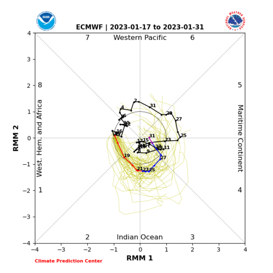
From JB
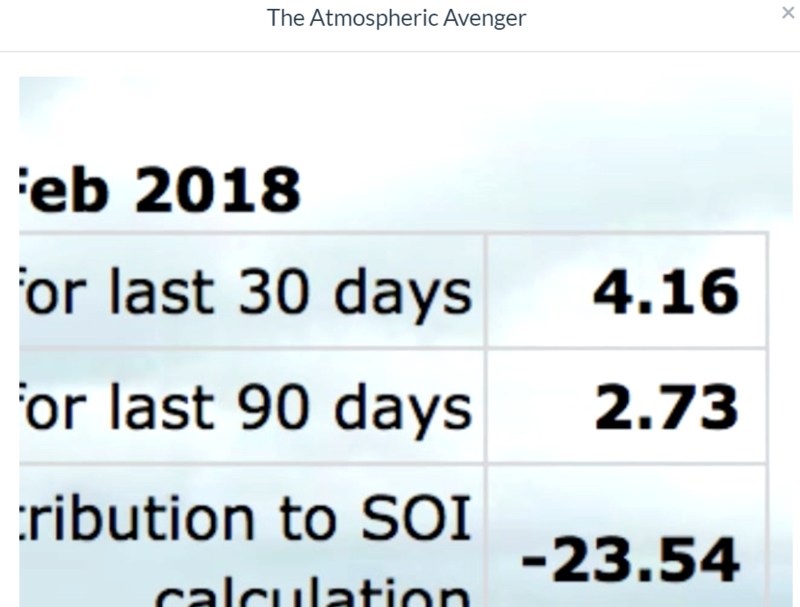
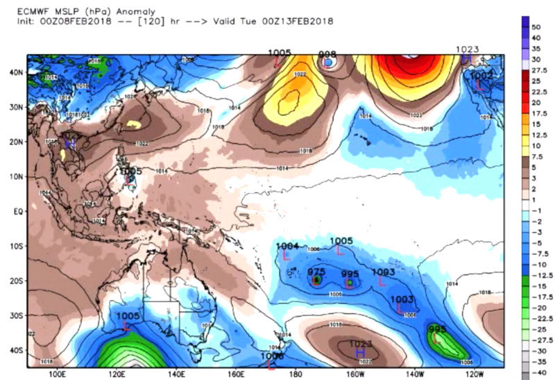
https://twitter.com/TropicalTidbits/status/961617611820814336
_________________
Mugs
AKA:King: Snow Weenie
Self Proclaimed
WINTER 2014-15 : 55.12" +.02 for 6 coatings (avg. 35")
WINTER 2015-16 Total - 29.8" (Avg 35")
WINTER 2016-17 : 39.5" so far

amugs- Advanced Forecaster - Mod

- Posts : 15157
Reputation : 213
Join date : 2013-01-07
Age : 54
Location : Hillsdale,NJ
 Re: Long Range Thread 16.0
I share with you two posts by one by mini Earthlight and Earthlight himself :
mini Earthlight
expect a MECS+ somewhere on the EC from Feb 25-Mar 15. The coupling of the SSW and its effects on high latitude blocking will suppress the TPV southward. This will result in an elongated TPV (which is what we saw before; it produced) along with a stout -NAO/AO. The N Pacific is more uncertain, but the Phase 8-1 MJO is favorable for WC ridging, and it is certainly possible that the high latitude blocking may enter into the EPO and WPO domains.
All of these factors lead me to believe that we will see the highest impact system of this winter during the period mentioned above. This will most likely occur as the -NAO/AO starts to weaken, which i see occurring during the second week of March. I also anticipate a smaller winter storm threat as the pattern initially settles in during the Feb 20-26 period. Buckle up.
EARTHLIGHT:
One of the things I continue to stress both here and to our clients/etc is the lack of confidence regarding cold air invading the USA. It should be made consistently clear that this SSW does not guarantee anomalous cold will flow into the USA. Despite the shifting -NAM state and development of a -AO, the Pacific pattern remains in flux initially as the NPO forecast offers a huge spread. This is evidenced on ensembles with tremendous muting occurring in the medium range.
With that being said, there should be zero concern about that in the Northeast. In fact, there should be the opposite - excitement. The development of a large ridge in the Barents/Kara sea is supported by all ensemble guidance which will impact the positioning of the tropospheric pv over Canada. As the MJO moves into more favorable phases and tropical forcing begins to impact the Pacific pattern we should see a favorable developing waveguide. Multiple disturbances should be at play as we move forward into the latter part of February. High latitude ridging will nose down into Greenland and residual ridging over Alaska will keep at least a reasonable and favorable cold air source to our North.

_________________
Mugs
AKA:King: Snow Weenie
Self Proclaimed
WINTER 2014-15 : 55.12" +.02 for 6 coatings (avg. 35")
WINTER 2015-16 Total - 29.8" (Avg 35")
WINTER 2016-17 : 39.5" so far

amugs- Advanced Forecaster - Mod

- Posts : 15157
Reputation : 213
Join date : 2013-01-07
Age : 54
Location : Hillsdale,NJ
 Re: Long Range Thread 16.0
amugs wrote:I share with you two posts by one by mini Earthlight and Earthlight himself :
mini Earthlight
expect a MECS+ somewhere on the EC from Feb 25-Mar 15. The coupling of the SSW and its effects on high latitude blocking will suppress the TPV southward. This will result in an elongated TPV (which is what we saw before; it produced) along with a stout -NAO/AO. The N Pacific is more uncertain, but the Phase 8-1 MJO is favorable for WC ridging, and it is certainly possible that the high latitude blocking may enter into the EPO and WPO domains.
All of these factors lead me to believe that we will see the highest impact system of this winter during the period mentioned above. This will most likely occur as the -NAO/AO starts to weaken, which i see occurring during the second week of March. I also anticipate a smaller winter storm threat as the pattern initially settles in during the Feb 20-26 period. Buckle up.
EARTHLIGHT:
One of the things I continue to stress both here and to our clients/etc is the lack of confidence regarding cold air invading the USA. It should be made consistently clear that this SSW does not guarantee anomalous cold will flow into the USA. Despite the shifting -NAM state and development of a -AO, the Pacific pattern remains in flux initially as the NPO forecast offers a huge spread. This is evidenced on ensembles with tremendous muting occurring in the medium range.
With that being said, there should be zero concern about that in the Northeast. In fact, there should be the opposite - excitement. The development of a large ridge in the Barents/Kara sea is supported by all ensemble guidance which will impact the positioning of the tropospheric pv over Canada. As the MJO moves into more favorable phases and tropical forcing begins to impact the Pacific pattern we should see a favorable developing waveguide. Multiple disturbances should be at play as we move forward into the latter part of February. High latitude ridging will nose down into Greenland and residual ridging over Alaska will keep at least a reasonable and favorable cold air source to our North.
Ok, now that's encouraging lol. I am just not sure exactly who they are.
_________________
-Alex Iannone-

aiannone- Senior Enthusiast - Mod

- Posts : 4828
Reputation : 92
Join date : 2013-01-07
Location : Saint James, LI (Northwest Suffolk Co.)
 Re: Long Range Thread 16.0
sroc4 wrote:Ill tell you what. With how fast the strat will change over the next 7days, and how linked the strat and toposphere are with each other with this SSWE occurring once the models figure out how it will affect the atmosphere do not be surprised to see DRASTIC flipping in the modeling over the next few days. Flipping for the better. Ray in his frustrated post earlier eluded to this as well...lol
I mean look at the teleconnections on the GEFS and how literally they are doing an about face on todays 12z. Now keep in mind this is nothing more than a graph and its the first run, but by the 16th or so if the GEFS are correct we could be staring down the barrel of a -EPO/-AO/-NAO blocking pattern setting up. We have to keep an eye on the modeling because its going to change.
EPO 00z Feb 5th, 00z Feb 7th, and 12z Feb 12th
AO Same dates
NAO same dates:
Great analysis, as always, Scott!
_________________
-Alex Iannone-

aiannone- Senior Enthusiast - Mod

- Posts : 4828
Reputation : 92
Join date : 2013-01-07
Location : Saint James, LI (Northwest Suffolk Co.)
 Re: Long Range Thread 16.0
I can't wait for everything to align to get a storm but not while I'm in Florida! March 4-11th it has to be cold and dry here! LGM!
_________________
Janet
Snowfall winter of 2023-2024 17.5"
Snowfall winter of 2022-2023 6.0"
Snowfall winter of 2021-2022 17.6" 1" sleet 2/25/22
Snowfall winter of 2020-2021 51.1"
Snowfall winter of 2019-2020 8.5"
Snowfall winter of 2018-2019 25.1"
Snowfall winter of 2017-2018 51.9"
Snowfall winter of 2016-2017 45.6"
Snowfall winter of 2015-2016 29.5"
Snowfall winter of 2014-2015 50.55"
Snowfall winter of 2013-2014 66.5"

Dunnzoo- Senior Enthusiast - Mod

- Posts : 4938
Reputation : 68
Join date : 2013-01-11
Age : 62
Location : Westwood, NJ
 Re: Long Range Thread 16.0
Loving my 15 day of ranging from 37 to 55. Just aweful this is no winter. Please tell me this will change otherwise I think we can say we had our last snow and it's spring already.

jmanley32- Senior Enthusiast

- Posts : 20648
Reputation : 108
Join date : 2013-12-12
Age : 43
Location : Yonkers, NY
 Re: Long Range Thread 16.0
JMan, see Janet's post up there? Our huge snowstorm hits the week of March 4-11.

docstox12- Wx Statistician Guru

- Posts : 8617
Reputation : 222
Join date : 2013-01-07
Age : 74
Location : Monroe NY
 Re: Long Range Thread 16.0
I thought our pattern change back to snow storms will be the end of February into March
frank 638- Senior Enthusiast

- Posts : 2882
Reputation : 37
Join date : 2016-01-01
Age : 41
Location : bronx ny

aiannone- Senior Enthusiast - Mod

- Posts : 4828
Reputation : 92
Join date : 2013-01-07
Location : Saint James, LI (Northwest Suffolk Co.)
 Re: Long Range Thread 16.0
aiannone wrote:Steve D threw in the towel lol
Not so far fetched.We have had two below normal months in temps.Reversion to the mean could be mild from now on.The Long Range crew disagrees and hopefully they will be right.Fact is, however, time is passing.Presdient's Day to March 15 is the last chance to get a big snowstorm.After March 15th, it gets harder and harder for a big snowstorm.It happens but not very often.Here's hoping for the best!!!!!

docstox12- Wx Statistician Guru

- Posts : 8617
Reputation : 222
Join date : 2013-01-07
Age : 74
Location : Monroe NY
 Re: Long Range Thread 16.0
Evolution of the 10mb strat...Jan 23rd, Feb 3rd, Feb 9th...pay particular attention in the first two images there is a large ridge on the left side of the vortex, but in the last 5 days a second lobe/ridge has appeared on the R side. In 3 more days the ridges on the L and R sides will link over top of the arctic circle in spectacular fashion splitting the strat polar vortex into two lobes..
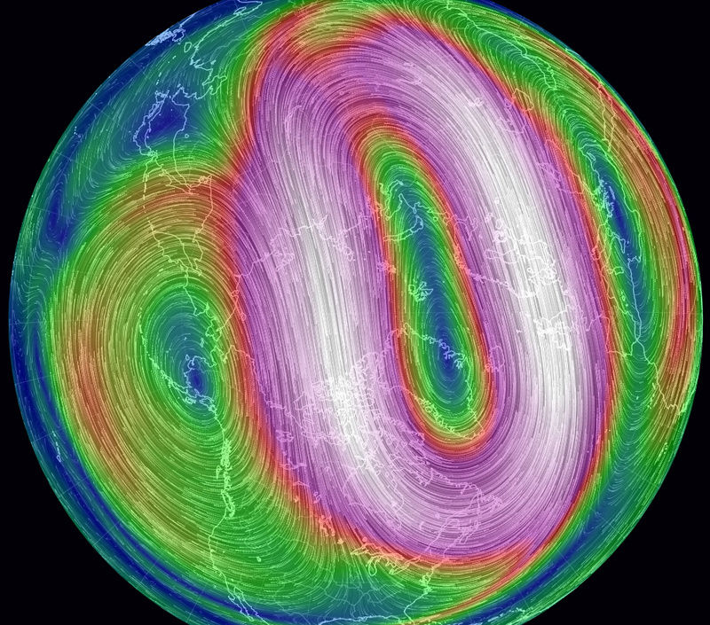
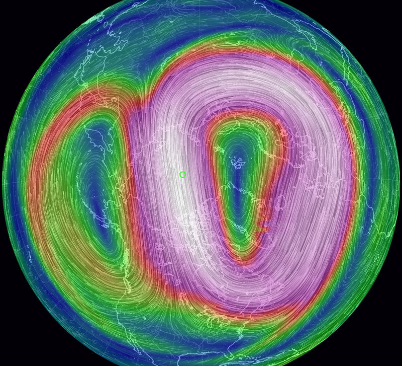

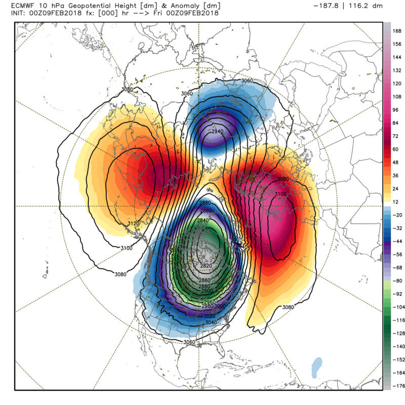
In 3 days it will look like this...

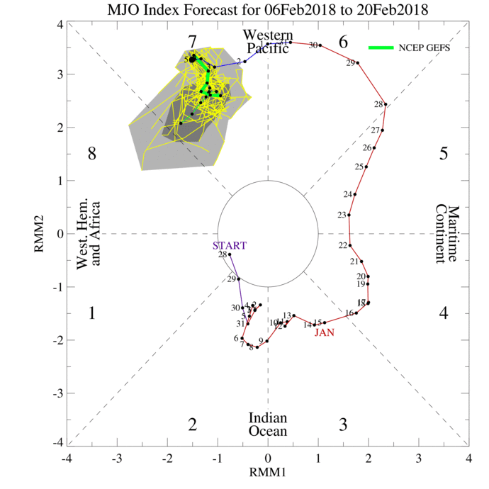
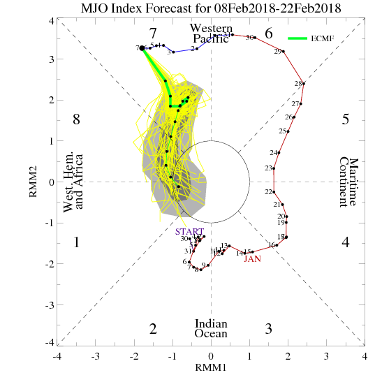
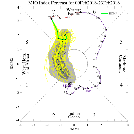
I mentioned yesterday the GFS has hands down been the better of the two between it and euro forecasting the MJO. Here was the GEFS MJO From Feb 6th showing the hint at phase 8 but Feb 7th its back to getting stuck in 7 vs the euro that still seems to be correcting to the GEFS but still has it decreasing amplitude and getting into 8. Until I see the MJO make some headway towards 8 I will pause....BUT with how significant (I and I cant stress this enough) the changes will be to the strat in the upcoming 3-7days, there will be a huge atmospheric shake up. The period to watch is Feb20th-23rd-Mid March for the real deal Holyfield, but I am still watching the 16th-18th VERY closely for a wintery event.



In 3 days it will look like this...

I mentioned yesterday the GFS has hands down been the better of the two between it and euro forecasting the MJO. Here was the GEFS MJO From Feb 6th showing the hint at phase 8 but Feb 7th its back to getting stuck in 7 vs the euro that still seems to be correcting to the GEFS but still has it decreasing amplitude and getting into 8. Until I see the MJO make some headway towards 8 I will pause....BUT with how significant (I and I cant stress this enough) the changes will be to the strat in the upcoming 3-7days, there will be a huge atmospheric shake up. The period to watch is Feb20th-23rd-Mid March for the real deal Holyfield, but I am still watching the 16th-18th VERY closely for a wintery event.


_________________
"In weather and in life, there's no winning and losing; there's only winning and learning."
WINTER 2012/2013 TOTALS 43.65"WINTER 2017/2018 TOTALS 62.85" WINTER 2022/2023 TOTALS 4.9"
WINTER 2013/2014 TOTALS 64.85"WINTER 2018/2019 TOTALS 14.25" WINTER 2023/2024 TOTALS 13.1"
WINTER 2014/2015 TOTALS 71.20"WINTER 2019/2020 TOTALS 6.35" WINTER 2024/2025 TOTALS 0.00
WINTER 2015/2016 TOTALS 35.00"WINTER 2020/2021 TOTALS 37.75"
WINTER 2016/2017 TOTALS 42.25"WINTER 2021/2022 TOTALS 31.65"

sroc4- Admin

- Posts : 8459
Reputation : 302
Join date : 2013-01-07
Location : Wading River, LI
 Re: Long Range Thread 16.0
sroc4 wrote:
I mentioned yesterday the GFS has hands down been the better of the two between it and euro forecasting the MJO. Here was the GEFS MJO From Feb 6th showing the hint at phase 8 but Feb 7th its back to getting stuck in 7 vs the euro that still seems to be correcting to the GEFS but still has it decreasing amplitude and getting into 8. Until I see the MJO make some headway towards 8 I will pause....BUT with how significant (I and I cant stress this enough) the changes will be to the strat in the upcoming 3-7days, there will be a huge atmospheric shake up. The period to watch is Feb20th-23rd-Mid March for the real deal Holyfield, but I am still watching the 16th-18th VERY closely for a wintery event.
And here is todays MJO forecasts...GEFS then EURO. Alot of volitility

_________________
"In weather and in life, there's no winning and losing; there's only winning and learning."
WINTER 2012/2013 TOTALS 43.65"WINTER 2017/2018 TOTALS 62.85" WINTER 2022/2023 TOTALS 4.9"
WINTER 2013/2014 TOTALS 64.85"WINTER 2018/2019 TOTALS 14.25" WINTER 2023/2024 TOTALS 13.1"
WINTER 2014/2015 TOTALS 71.20"WINTER 2019/2020 TOTALS 6.35" WINTER 2024/2025 TOTALS 0.00
WINTER 2015/2016 TOTALS 35.00"WINTER 2020/2021 TOTALS 37.75"
WINTER 2016/2017 TOTALS 42.25"WINTER 2021/2022 TOTALS 31.65"

sroc4- Admin

- Posts : 8459
Reputation : 302
Join date : 2013-01-07
Location : Wading River, LI
 Re: Long Range Thread 16.0
sroc4 wrote:Evolution of the 10mb strat...Jan 23rd, Feb 3rd, Feb 9th...pay particular attention in the first two images there is a large ridge on the left side of the vortex, but in the last 5 days a second lobe/ridge has appeared on the R side. In 3 more days the ridges on the L and R sides will link over top of the arctic circle in spectacular fashion splitting the strat polar vortex into two lobes..
In 3 days it will look like this...
I mentioned yesterday the GFS has hands down been the better of the two between it and euro forecasting the MJO. Here was the GEFS MJO From Feb 6th showing the hint at phase 8 but Feb 7th its back to getting stuck in 7 vs the euro that still seems to be correcting to the GEFS but still has it decreasing amplitude and getting into 8. Until I see the MJO make some headway towards 8 I will pause....BUT with how significant (I and I cant stress this enough) the changes will be to the strat in the upcoming 3-7days, there will be a huge atmospheric shake up. The period to watch is Feb20th-23rd-Mid March for the real deal Holyfield, but I am still watching the 16th-18th VERY closely for a wintery event.
Scroc...I have faith..not giving up!! ps..where did you get the top three maps from they are really beautiful to see....

weatherwatchermom- Senior Enthusiast

- Posts : 3896
Reputation : 78
Join date : 2014-11-25
Location : Hazlet Township, NJ
 Re: Long Range Thread 16.0
weatherwatchermom wrote:sroc4 wrote:Evolution of the 10mb strat...Jan 23rd, Feb 3rd, Feb 9th...pay particular attention in the first two images there is a large ridge on the left side of the vortex, but in the last 5 days a second lobe/ridge has appeared on the R side. In 3 more days the ridges on the L and R sides will link over top of the arctic circle in spectacular fashion splitting the strat polar vortex into two lobes..
I mentioned yesterday the GFS has hands down been the better of the two between it and euro forecasting the MJO. Here was the GEFS MJO From Feb 6th showing the hint at phase 8 but Feb 7th its back to getting stuck in 7 vs the euro that still seems to be correcting to the GEFS but still has it decreasing amplitude and getting into 8. Until I see the MJO make some headway towards 8 I will pause....BUT with how significant (I and I cant stress this enough) the changes will be to the strat in the upcoming 3-7days, there will be a huge atmospheric shake up. The period to watch is Feb20th-23rd-Mid March for the real deal Holyfield, but I am still watching the 16th-18th VERY closely for a wintery event.
Scroc...I have faith..not giving up!! ps..where did you get the top three maps from they are really beautiful to see....
Here is the link. Its a really cool site. Hover the mouse over the earth and left click and hold it down. You can then adjust your view of the globe. With the little wheel thing in between left and right click bottons on the mouse you can zoom in or out over any specific location. In the bottom L corner click on the word earth and you can pick which level of the atmosphere you want to look at from sfc to 10mb(or HPa) in the atmosphere where it says height. You can also switch and look at ocean currents as well. Its a great site.
https://earth.nullschool.net/#current/wind/isobaric/500hPa/orthographic=-97.37,21.15,420
_________________
"In weather and in life, there's no winning and losing; there's only winning and learning."
WINTER 2012/2013 TOTALS 43.65"WINTER 2017/2018 TOTALS 62.85" WINTER 2022/2023 TOTALS 4.9"
WINTER 2013/2014 TOTALS 64.85"WINTER 2018/2019 TOTALS 14.25" WINTER 2023/2024 TOTALS 13.1"
WINTER 2014/2015 TOTALS 71.20"WINTER 2019/2020 TOTALS 6.35" WINTER 2024/2025 TOTALS 0.00
WINTER 2015/2016 TOTALS 35.00"WINTER 2020/2021 TOTALS 37.75"
WINTER 2016/2017 TOTALS 42.25"WINTER 2021/2022 TOTALS 31.65"

sroc4- Admin

- Posts : 8459
Reputation : 302
Join date : 2013-01-07
Location : Wading River, LI
Page 39 of 40 •  1 ... 21 ... 38, 39, 40
Page 39 of 40
Permissions in this forum:
You cannot reply to topics in this forum
 Home
Home

