Long Range Thread 16.0
+53
dad4twoboys
toople
Aiosamoney21
Vinnydula
jimv45
petep10
Taffy
lglickman1
mikeypizano
SNOW MAN
Sanchize06
devsman
Nyi1058
mwilli5783
Sparky Sparticles
Smittyaj623
adamfitz1969
essexcountypete
weatherwatchermom
rb924119
oldtimer
sabamfa
Radz
GreyBeard
Scullybutcher
SnowForest
dkodgis
WeatherBob
Carter bk
Math23x7
SENJsnowman
RJB8525
Quietace
nutleyblizzard
docstox12
NjWeatherGuy
Dunnzoo
frank 638
jmanley32
billg315
skinsfan1177
SoulSingMG
Grselig
aiannone
algae888
Snow88
sroc4
MattyICE
Frank_Wx
crippo84
CPcantmeasuresnow
track17
amugs
57 posters
Page 2 of 34
Page 2 of 34 •  1, 2, 3 ... 18 ... 34
 Re: Long Range Thread 16.0
AO is freefalling to -5
http://www.cpc.ncep.noaa.gov/products/precip/CWlink/daily_ao_index/ao.shtml
NAO going down to -2
http://www.cpc.ncep.noaa.gov/products/precip/CWlink/daily_ao_index/ao.shtml
http://www.cpc.ncep.noaa.gov/products/precip/CWlink/daily_ao_index/ao.shtml
NAO going down to -2
http://www.cpc.ncep.noaa.gov/products/precip/CWlink/daily_ao_index/ao.shtml
Snow88- Senior Enthusiast

- Posts : 2193
Join date : 2013-01-09
 Re: Long Range Thread 16.0
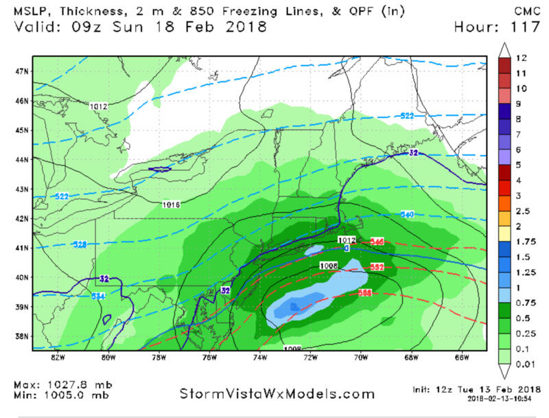
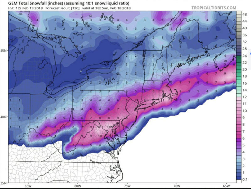
CMC and German show a coastal snow storm
Snow88- Senior Enthusiast

- Posts : 2193
Join date : 2013-01-09
 Re: Long Range Thread 16.0
Snow88 wrote:AO is freefalling to -5
http://www.cpc.ncep.noaa.gov/products/precip/CWlink/daily_ao_index/ao.shtml
NAO going down to -2
http://www.cpc.ncep.noaa.gov/products/precip/CWlink/daily_ao_index/ao.shtml
If these projections are correct there is no way escape with out at least one MECS. Count on it
_________________
"In weather and in life, there's no winning and losing; there's only winning and learning."
WINTER 2012/2013 TOTALS 43.65"WINTER 2017/2018 TOTALS 62.85" WINTER 2022/2023 TOTALS 4.9"
WINTER 2013/2014 TOTALS 64.85"WINTER 2018/2019 TOTALS 14.25" WINTER 2023/2024 TOTALS 13.1"
WINTER 2014/2015 TOTALS 71.20"WINTER 2019/2020 TOTALS 6.35" WINTER 2024/2025 TOTALS 0.00
WINTER 2015/2016 TOTALS 35.00"WINTER 2020/2021 TOTALS 37.75"
WINTER 2016/2017 TOTALS 42.25"WINTER 2021/2022 TOTALS 31.65"

sroc4- Admin

- Posts : 8458
Reputation : 302
Join date : 2013-01-07
Location : Wading River, LI

aiannone- Senior Enthusiast - Mod

- Posts : 4827
Reputation : 92
Join date : 2013-01-07
Location : Saint James, LI (Northwest Suffolk Co.)

aiannone- Senior Enthusiast - Mod

- Posts : 4827
Reputation : 92
Join date : 2013-01-07
Location : Saint James, LI (Northwest Suffolk Co.)
 Re: Long Range Thread 16.0
I want it as bad as the next guy. But like I said, hard to get on board when it’s the CMC and German alone.
MattyICE- Advanced Forecaster

- Posts : 249
Reputation : 6
Join date : 2017-11-10
Age : 39
Location : Clifton, NJ (Eastern Passaic County)

aiannone- Senior Enthusiast - Mod

- Posts : 4827
Reputation : 92
Join date : 2013-01-07
Location : Saint James, LI (Northwest Suffolk Co.)
 Re: Long Range Thread 16.0
MattyICE wrote:I want it as bad as the next guy. But like I said, hard to get on board when it’s the CMC and German alone.
Germany is currently leading the Winter Olympics gold medal count with Canada not too far behind them in 4th. Maybe...it's a sign.

crippo84- Posts : 383
Reputation : 20
Join date : 2013-11-07
Age : 40
Location : East Village, NYC
 Re: Long Range Thread 16.0
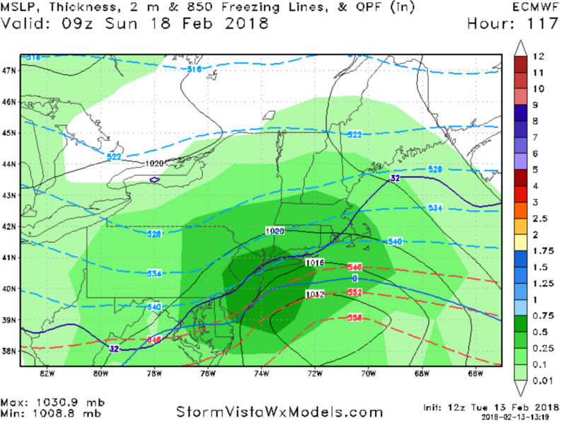
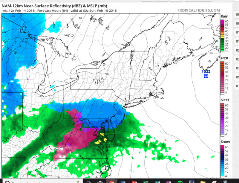
Euro on board for a snow storm Saturday night into Sunday morning

algae888- Advanced Forecaster

- Posts : 5311
Reputation : 46
Join date : 2013-02-05
Age : 62
Location : mt. vernon, new york
 Re: Long Range Thread 16.0
algae888 wrote:Euro on board for a snow storm Saturday night into Sunday morning
Like [X] [X] [X] [X] [X] [X] [X] [X] [X] [X] [X] [X] [X] [X] [X] [X]

CPcantmeasuresnow- Wx Statistician Guru

- Posts : 7282
Reputation : 230
Join date : 2013-01-07
Age : 103
Location : Eastern Orange County, NY

aiannone- Senior Enthusiast - Mod

- Posts : 4827
Reputation : 92
Join date : 2013-01-07
Location : Saint James, LI (Northwest Suffolk Co.)
 Re: Long Range Thread 16.0
Guess I spoke to soon. Lol. However, we ALL know it’s in the meso/short range this year. Will have to see that hand off in the next day or two.
MattyICE- Advanced Forecaster

- Posts : 249
Reputation : 6
Join date : 2017-11-10
Age : 39
Location : Clifton, NJ (Eastern Passaic County)
 Re: Long Range Thread 16.0
CPcantmeasuresnow wrote:algae888 wrote:Euro on board for a snow storm Saturday night into Sunday morning
Like [X] [X] [X] [X] [X] [X] [X] [X] [X] [X] [X] [X] [X] [X] [X] [X]
[X] [X] [X] [X] [X] [X] [X] [X] [X] [X] [X] [X] [X] [X] [X] [X][ [X] [X] [X] [X] [X] [X] [X] [X] [X] [X] [X] [X] [X] [X] [X] [X][ [X] [X] [X] [X] [X] [X] [X] [X] [X] [X] [X] [X] [X] [X] [X] [X][ [X] [X] [X] [X] [X] [X] [X] [X] [X] [X] [X] [X] [X] [X] [X] [X][ [X] [X] [X] [X] [X] [X] [X] [X] [X] [X] [X] [X] [X] [X] [X] [X][ [X] [X] [X] [X] [X] [X] [X] [X] [X] [X] [X] [X] [X] [X] [X] [X][ [X] [X] [X] [X] [X] [X] [X] [X] [X] [X] [X] [X] [X] [X] [X] [X][ [X] [X] [X] [X] [X] [X] [X] [X] [X] [X] [X] [X] [X] [X] [X] [X][ [X] [X] [X] [X] [X] [X] [X] [X] [X] [X] [X] [X] [X] [X] [X] [X][ [X] [X] [X] [X] [X] [X] [X] [X] [X] [X] [X] [X] [X] [X] [X] [X][
OK This is banter. But it feels nice to have positive vibes here.
Grselig- Senior Enthusiast

- Posts : 1410
Reputation : 140
Join date : 2013-03-04
Age : 54
Location : Wayne NJ
 Re: Long Range Thread 16.0
Some nice runs today. GFS 18z just shifted north because the northers s/w is stronger a tad slower and a tad deeper. Stay cautiously optimistic. Another day or two of positive trends and we will start a new thread. Winter is not over.
_________________
"In weather and in life, there's no winning and losing; there's only winning and learning."
WINTER 2012/2013 TOTALS 43.65"WINTER 2017/2018 TOTALS 62.85" WINTER 2022/2023 TOTALS 4.9"
WINTER 2013/2014 TOTALS 64.85"WINTER 2018/2019 TOTALS 14.25" WINTER 2023/2024 TOTALS 13.1"
WINTER 2014/2015 TOTALS 71.20"WINTER 2019/2020 TOTALS 6.35" WINTER 2024/2025 TOTALS 0.00
WINTER 2015/2016 TOTALS 35.00"WINTER 2020/2021 TOTALS 37.75"
WINTER 2016/2017 TOTALS 42.25"WINTER 2021/2022 TOTALS 31.65"

sroc4- Admin

- Posts : 8458
Reputation : 302
Join date : 2013-01-07
Location : Wading River, LI
 Re: Long Range Thread 16.0
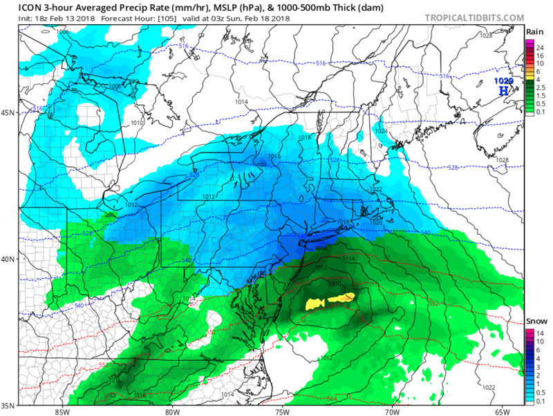
ICON staying consistent with its solution over the past couple days as well

_________________
-Alex Iannone-

aiannone- Senior Enthusiast - Mod

- Posts : 4827
Reputation : 92
Join date : 2013-01-07
Location : Saint James, LI (Northwest Suffolk Co.)
 Re: Long Range Thread 16.0
00z GFS caves
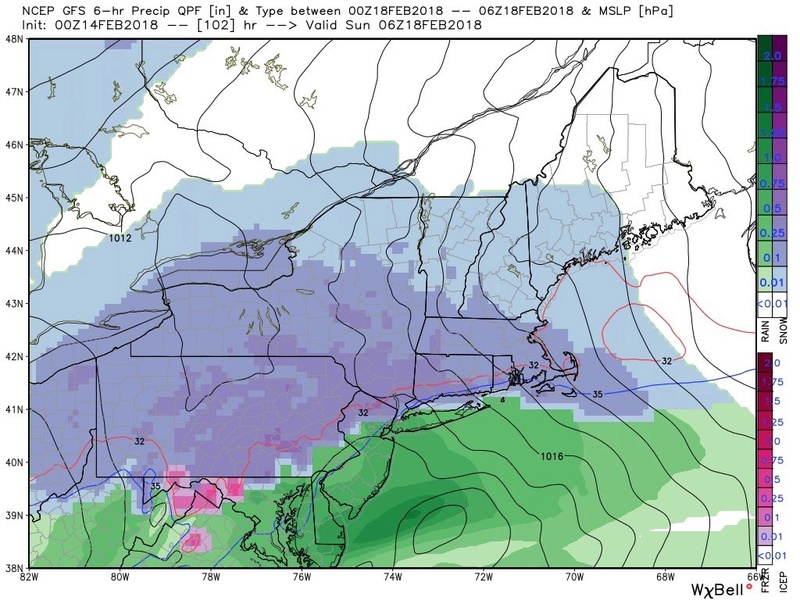 We
We
 We
We
SoulSingMG- Senior Enthusiast

- Posts : 2853
Reputation : 74
Join date : 2013-12-11
Location : Long Island City, NY

aiannone- Senior Enthusiast - Mod

- Posts : 4827
Reputation : 92
Join date : 2013-01-07
Location : Saint James, LI (Northwest Suffolk Co.)
 Re: Long Range Thread 16.0
Not liking by his threat

skinsfan1177- Senior Enthusiast

- Posts : 4485
Reputation : 35
Join date : 2013-01-07
Age : 47
Location : Point Pleasant Boro
 Re: Long Range Thread 16.0
Have no fear. All storms have shifted nw inside of 48 hours. By Tomorrow night we will all be forecast for rain except extreme nw guys
Guest- Guest
 Re: Long Range Thread 16.0
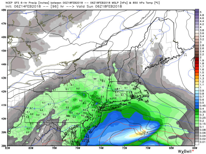
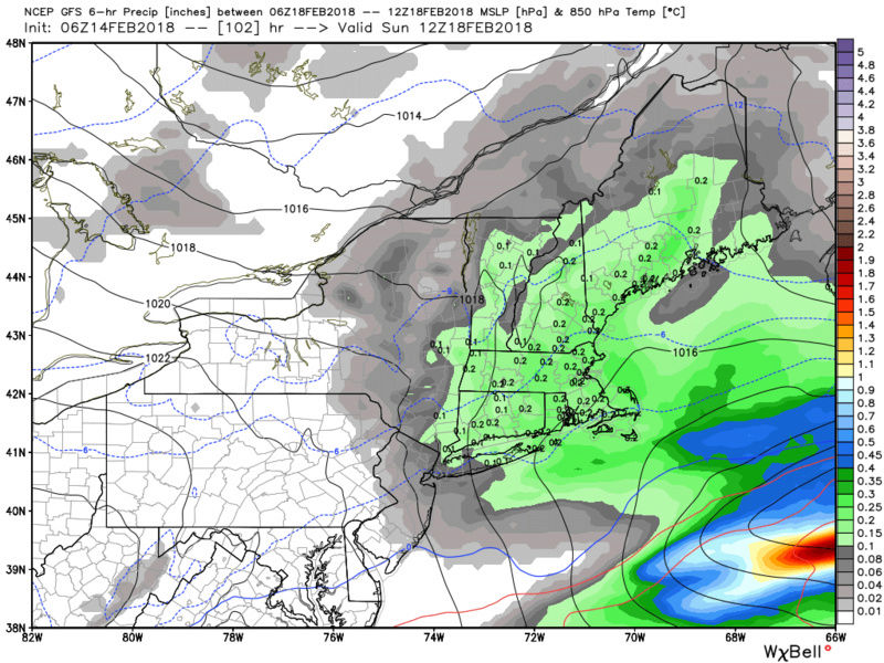
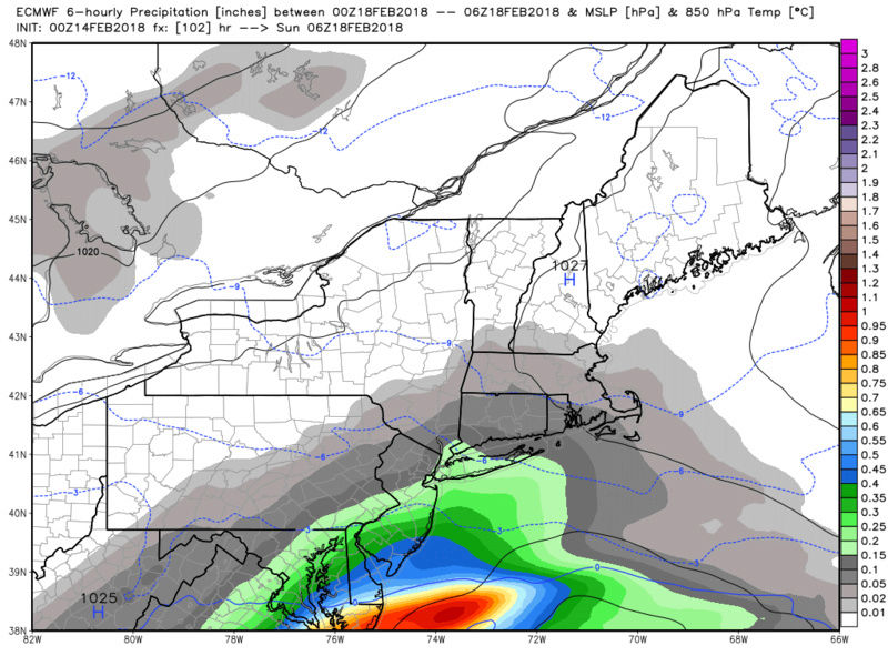
Model update:
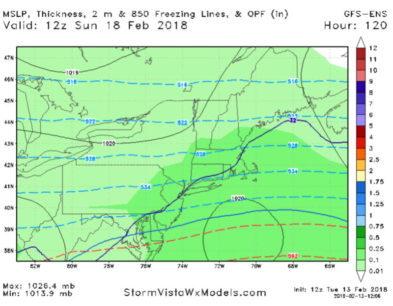
1) GFS:
2) EURO:
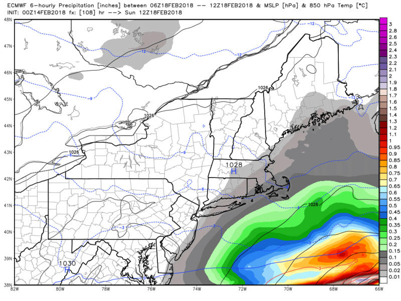
3) CMC:
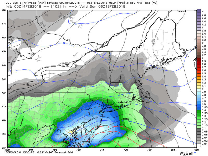
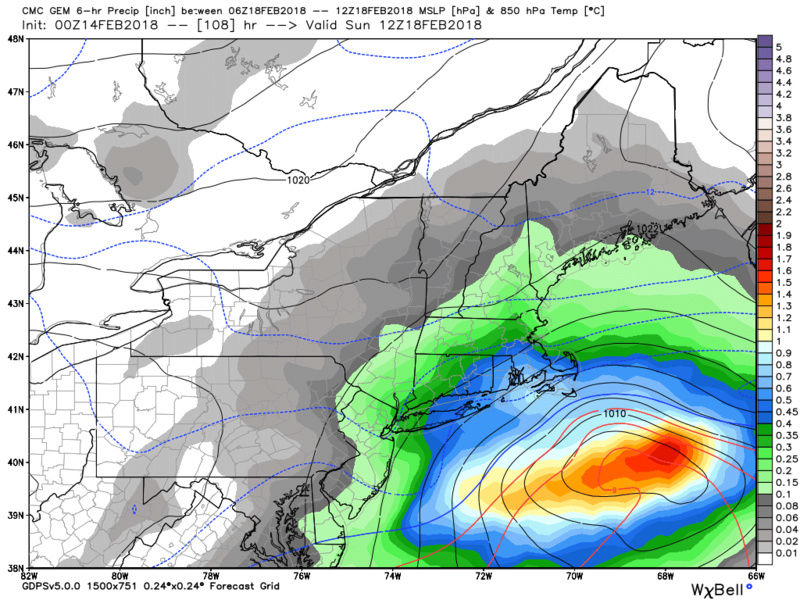
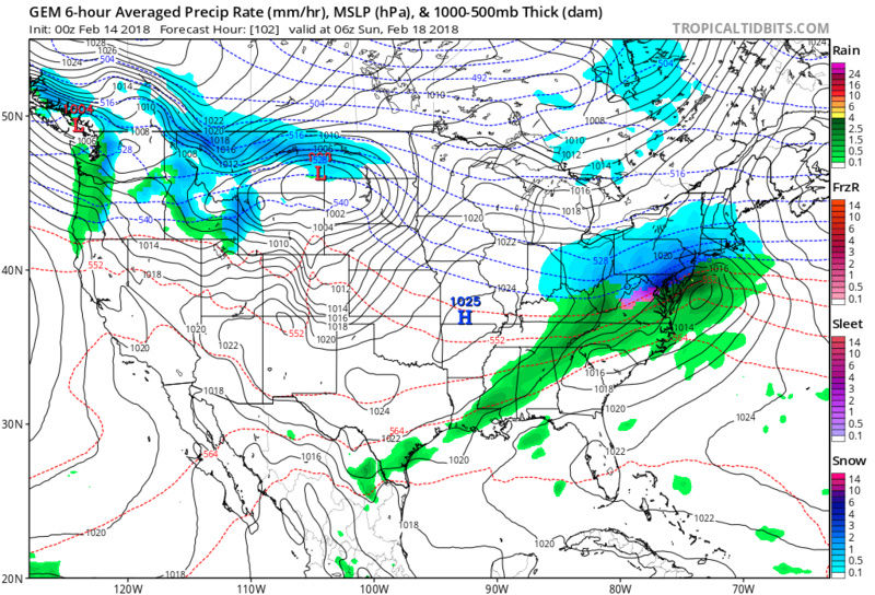
I normally don't like surface maps, esp this far out, but for now we have a snow to sleet to rain scenario ; maybe back to snow for the coastal plain, with N&W holding on longer and possibly the entire time. I'm not quite ready to make any specific predictions about this system except to say a few things.
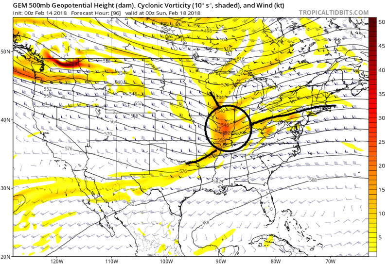
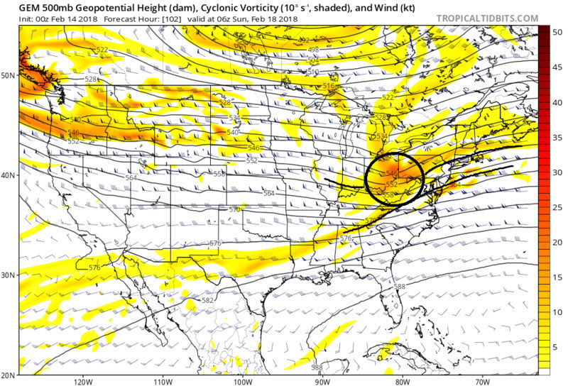
First the pattern isn't great for this to be a big storm, both up stream and down stream, so temper expectations on what to pick up out of this. That said this is not impossible for some to get a decent 3-6, maybe 4-8" (my ceiling) if things go perfect. One of the keys to this is just how strong is the northern vort and does it interact with the southern stream at all. Below is the current best case coldest scenario CMC vs the warmer soln of the GFS. As you can see that by the CMC by 12z Sat the N vort is interacting with the southern energy. It rides along the boundary all the way to the coast to form a stronger more organized surface LP(SLP) exiting the coast to our south. The key here is the interaction with the southern stream. This allows the SLP to draw in the colder air.
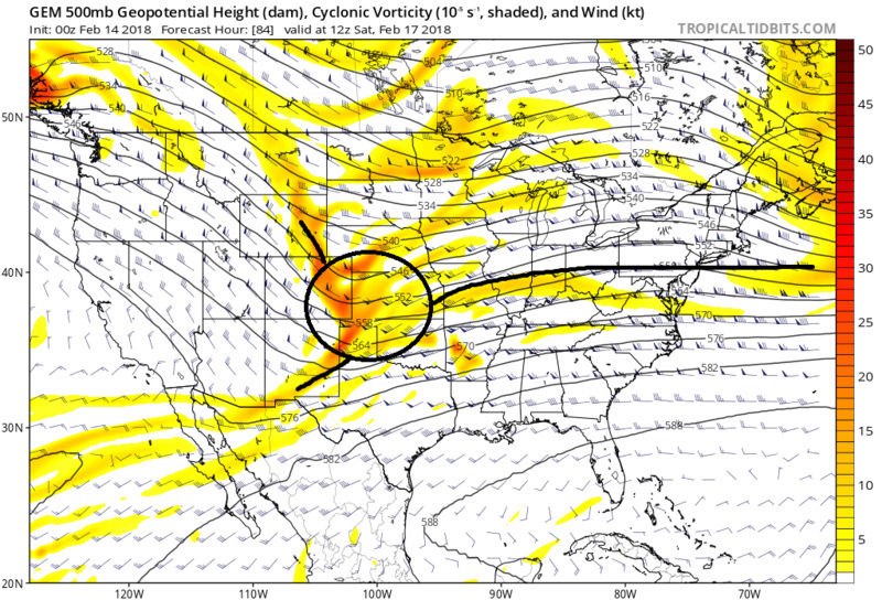
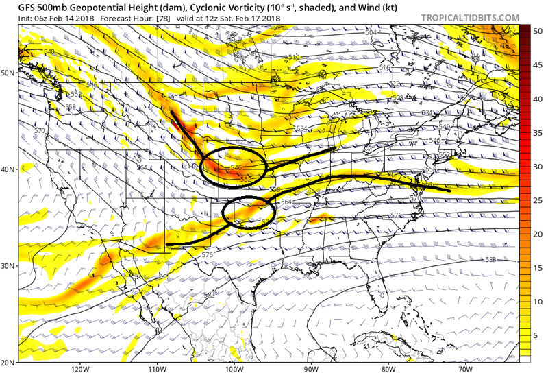
Now look at the GFS. Compared to the CMC by 12z Sat you can see the northern energy and southern energy have not interacted and is not as far south. As the energy moves eastit remains separated by a small margin, but just enough such that when we reach the coast the SLP struggles to draw in colder air
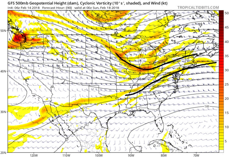

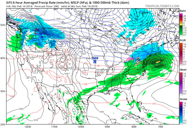
In both scenarios we have a cold HP to the north which gives us a fresh injection of cold air ahead of the storm. However, also in both scenarios, the HP is retreating off the coast because there is no blocking to prevent its escape. This likely allows the warm air surge ahead of the SLP to occur changing the wind direction from the north to the east and SE. This is almost identical set up to the past few systems to come our way. Keep in mind cold air likes to hold tough for longer than is modeled at least on the surface, but probability says that we all start as snow before the coastal plain changes over and areas N&W have the best shot at either not changing over or minimally changing over. As long as the storm track doesn't come too much farther North, N&W of the city should do ok whereas the coast gets oogatz like it has prev. However, its also still possible that the storm track ends up a little south of where guidance currently is which helps the coast but limits precip N&W if its not too far south, or passes too far south and misses us all. All this said we still have a long way to go. The northern energy does not come onshore for at least 48-72 hrs so....
We Track! In a pattern THAT SUCKS!...FOR NOW. Long range changes still look good as we end the month and begin March.
1) GFS:


2) EURO:


3) CMC:


I normally don't like surface maps, esp this far out, but for now we have a snow to sleet to rain scenario ; maybe back to snow for the coastal plain, with N&W holding on longer and possibly the entire time. I'm not quite ready to make any specific predictions about this system except to say a few things.
First the pattern isn't great for this to be a big storm, both up stream and down stream, so temper expectations on what to pick up out of this. That said this is not impossible for some to get a decent 3-6, maybe 4-8" (my ceiling) if things go perfect. One of the keys to this is just how strong is the northern vort and does it interact with the southern stream at all. Below is the current best case coldest scenario CMC vs the warmer soln of the GFS. As you can see that by the CMC by 12z Sat the N vort is interacting with the southern energy. It rides along the boundary all the way to the coast to form a stronger more organized surface LP(SLP) exiting the coast to our south. The key here is the interaction with the southern stream. This allows the SLP to draw in the colder air.


Now look at the GFS. Compared to the CMC by 12z Sat you can see the northern energy and southern energy have not interacted and is not as far south. As the energy moves eastit remains separated by a small margin, but just enough such that when we reach the coast the SLP struggles to draw in colder air


In both scenarios we have a cold HP to the north which gives us a fresh injection of cold air ahead of the storm. However, also in both scenarios, the HP is retreating off the coast because there is no blocking to prevent its escape. This likely allows the warm air surge ahead of the SLP to occur changing the wind direction from the north to the east and SE. This is almost identical set up to the past few systems to come our way. Keep in mind cold air likes to hold tough for longer than is modeled at least on the surface, but probability says that we all start as snow before the coastal plain changes over and areas N&W have the best shot at either not changing over or minimally changing over. As long as the storm track doesn't come too much farther North, N&W of the city should do ok whereas the coast gets oogatz like it has prev. However, its also still possible that the storm track ends up a little south of where guidance currently is which helps the coast but limits precip N&W if its not too far south, or passes too far south and misses us all. All this said we still have a long way to go. The northern energy does not come onshore for at least 48-72 hrs so....
We Track!
 In a pattern THAT SUCKS!...FOR NOW. Long range changes still look good as we end the month and begin March.
_________________
"In weather and in life, there's no winning and losing; there's only winning and learning."
WINTER 2012/2013 TOTALS 43.65"WINTER 2017/2018 TOTALS 62.85" WINTER 2022/2023 TOTALS 4.9"
WINTER 2013/2014 TOTALS 64.85"WINTER 2018/2019 TOTALS 14.25" WINTER 2023/2024 TOTALS 13.1"
WINTER 2014/2015 TOTALS 71.20"WINTER 2019/2020 TOTALS 6.35" WINTER 2024/2025 TOTALS 0.00
WINTER 2015/2016 TOTALS 35.00"WINTER 2020/2021 TOTALS 37.75"
WINTER 2016/2017 TOTALS 42.25"WINTER 2021/2022 TOTALS 31.65"

sroc4- Admin

- Posts : 8458
Reputation : 302
Join date : 2013-01-07
Location : Wading River, LI
 Re: Long Range Thread 16.0
CPcantmeasuresnow wrote:algae888 wrote:Euro on board for a snow storm Saturday night into Sunday morning
Like [X] [X] [X] [X] [X] [X] [X] [X] [X] [X] [X] [X] [X] [X] [X] [X]
A "like" feature is now available for each members post. You will see thumbs up in the upper right of the text box
_________________
_______________________________________________________________________________________________________
CLICK HERE to view NJ Strong Snowstorm Classifications
 Re: Long Range Thread 16.0
If we’re talking snow to rain IMBY I’d just rather have it be all rain thank you very much.
Guest- Guest

aiannone- Senior Enthusiast - Mod

- Posts : 4827
Reputation : 92
Join date : 2013-01-07
Location : Saint James, LI (Northwest Suffolk Co.)
 Re: Long Range Thread 16.0
I'm not too concerned about suppression with this system as we have a strong War. We also have the Ao and Nao tanking at this time and a slight rise in the PNA towards neutral. All good signs that this storm will hit us in one way or another. We also will have a fresh supply of arctic air however the high pressure system looks to be unfavorable at the moment but with the Nao tanking it could hold its ground more than what models are showing at the moment

algae888- Advanced Forecaster

- Posts : 5311
Reputation : 46
Join date : 2013-02-05
Age : 62
Location : mt. vernon, new york

aiannone- Senior Enthusiast - Mod

- Posts : 4827
Reputation : 92
Join date : 2013-01-07
Location : Saint James, LI (Northwest Suffolk Co.)
 Re: Long Range Thread 16.0
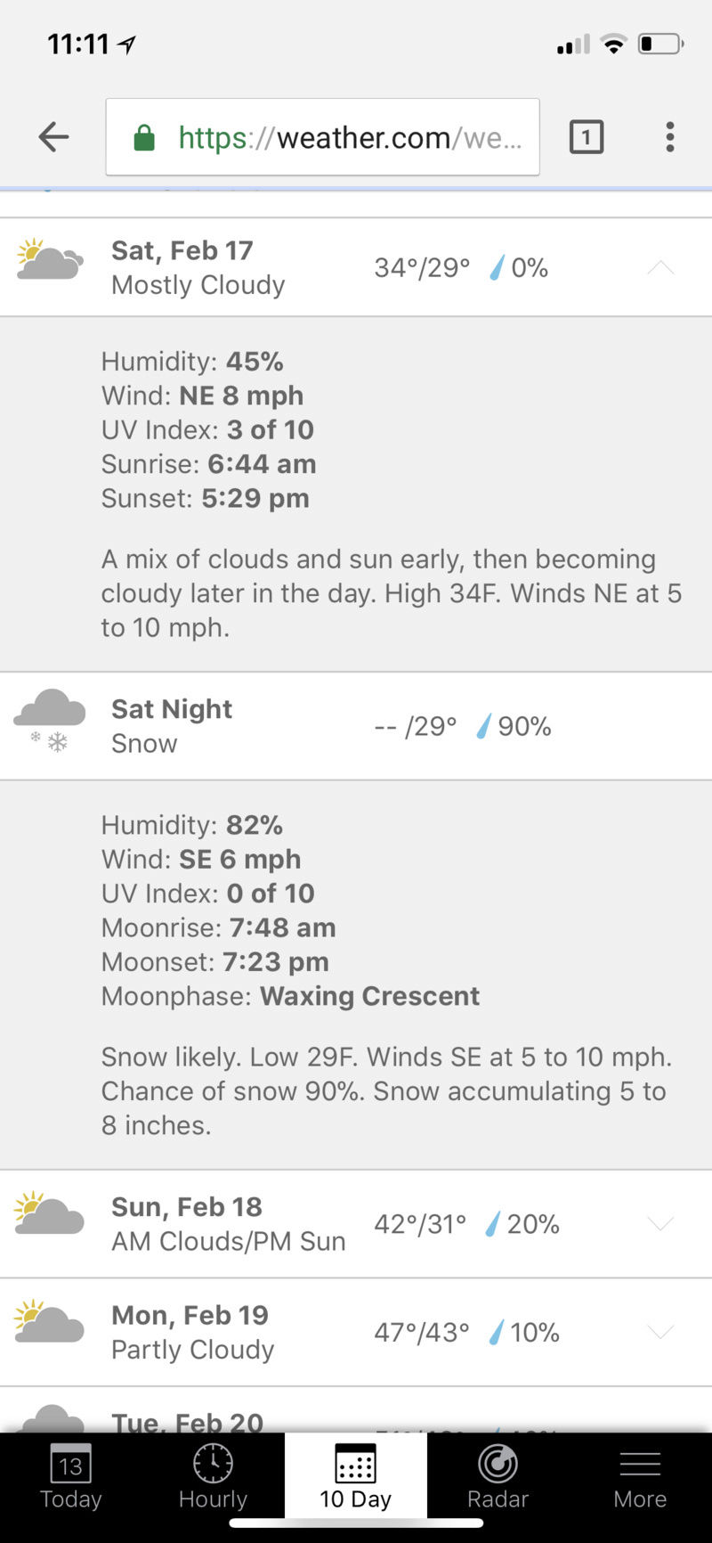
The surest sign that there will be significant snow in central and north Jersey and points north is that I will be at the shore in South Jersey this weekend for a polar plunge event. This almost guarantees there will be a half foot of snow in my backyard this Sunday while I'm not there (and probably that it will melt before I get home), while it rains in South Jersey.

billg315- Advanced Forecaster - Mod

- Posts : 4556
Reputation : 185
Join date : 2015-01-24
Age : 50
Location : Flemington, NJ
 Re: Long Range Thread 16.0
billg315 wrote:The surest sign that there will be significant snow in central and north Jersey and points north is that I will be at the shore in South Jersey this weekend for a polar plunge event. This almost guarantees there will be a half foot of snow in my backyard this Sunday while I'm not there (and probably that it will melt before I get home), while it rains in South Jersey.
and I will be in Mystic CT where I'm sure I will experience similar circumstances.
During the first substantial snow December 9th when we had six inches in the HV and 4.6 in NYC I was in Newport RI where they had an inch of snow washed away by the rain and onshore winds that quickly followed. It is my fate this year and I've accepted it.

CPcantmeasuresnow- Wx Statistician Guru

- Posts : 7282
Reputation : 230
Join date : 2013-01-07
Age : 103
Location : Eastern Orange County, NY
Page 2 of 34 •  1, 2, 3 ... 18 ... 34
Page 2 of 34
Permissions in this forum:
You cannot reply to topics in this forum
 Home
Home