Winter's Finale: March 20th-21st Snowstorm
+53
dsix85
emokid51783
lglickman1
gigs68
essexcountypete
Smittyaj623
Blaze
dsvinos
aiannone
Nyi1058
Math23x7
Scullybutcher
Taffy
jimv45
Artechmetals
oldtimer
Sanchize06
hurrysundown23
moleson
frank 638
Dunnzoo
hyde345
nujerzeedevil
Snow88
Quietace
SoulSingMG
richb521
adamfitz1969
Radz
GreyBeard
nutleyblizzard
CPcantmeasuresnow
bobjohnsonforthehall
mwilli5783
SNOW MAN
RJB8525
mikeypizano
SENJsnowman
jake732
billg315
dkodgis
Grselig
rb924119
sroc4
WeatherBob
weatherwatchermom
algae888
jmanley32
amugs
docstox12
skinsfan1177
Tzvi732
Frank_Wx
57 posters
Page 7 of 29
Page 7 of 29 •  1 ... 6, 7, 8 ... 18 ... 29
 Re: Winter's Finale: March 20th-21st Snowstorm
"Agreed Frank is probably on the level of Thor"
"Is anyone on this site God. Maybe Frank is"
You guys are creepy....
"Is anyone on this site God. Maybe Frank is"
You guys are creepy....
moleson- Posts : 34
Join date : 2013-01-07
 Re: Winter's Finale: March 20th-21st Snowstorm
Spring will arrive Wed with no snow whatsoever. Trees will start to bloom in a few weeks. What was a below snow season here in Central NJ now let's open the windows and breath the fresh air.
Again :NO MORE SNOW THIS WINTER SEASON"
I did not need a type of models to tell me this!
Again :NO MORE SNOW THIS WINTER SEASON"
I did not need a type of models to tell me this!
hurrysundown23- Posts : 53
Join date : 2017-01-04
 Re: Winter's Finale: March 20th-21st Snowstorm
0z NAM coming in slightly further north so far thru 45
Sanchize06- Senior Enthusiast

- Posts : 1041
Reputation : 21
Join date : 2013-02-05
Location : Union Beach, NJ
 Re: Winter's Finale: March 20th-21st Snowstorm
NAM is slightly north, but weaker and more disorganized
Sanchize06- Senior Enthusiast

- Posts : 1041
Reputation : 21
Join date : 2013-02-05
Location : Union Beach, NJ
Sanchize06- Senior Enthusiast

- Posts : 1041
Reputation : 21
Join date : 2013-02-05
Location : Union Beach, NJ
 Re: Winter's Finale: March 20th-21st Snowstorm
Sanchize06 wrote:NAM is slightly north, but weaker and more disorganized
Maybe tonights other 0Z's trend positive for us, if not let's see where we stand tomorrow night. I think we should have a good feel by then whether this will trend in out favor. We still have time on our side.

CPcantmeasuresnow- Wx Statistician Guru

- Posts : 7289
Reputation : 230
Join date : 2013-01-07
Age : 103
Location : Eastern Orange County, NY
 Re: Winter's Finale: March 20th-21st Snowstorm
Sanchize thanks for the play by play. Any maps?
Guest- Guest
Sanchize06- Senior Enthusiast

- Posts : 1041
Reputation : 21
Join date : 2013-02-05
Location : Union Beach, NJ
Sanchize06- Senior Enthusiast

- Posts : 1041
Reputation : 21
Join date : 2013-02-05
Location : Union Beach, NJ
 Re: Winter's Finale: March 20th-21st Snowstorm
CPcantmeasuresnow wrote:Sanchize06 wrote:NAM is slightly north, but weaker and more disorganized
Maybe tonights other 0Z's trend positive for us, if not let's see where we stand tomorrow night. I think we should have a good feel by then whether this will trend in out favor. We still have time on our side.
Yeah, we have plenty of time and it's possible a weaker first wave maybe could mean a stronger second one
Sanchize06- Senior Enthusiast

- Posts : 1041
Reputation : 21
Join date : 2013-02-05
Location : Union Beach, NJ
 Re: Winter's Finale: March 20th-21st Snowstorm
The 2nd part to this storm looks like it would be a nice hit for some


Sanchize06- Senior Enthusiast

- Posts : 1041
Reputation : 21
Join date : 2013-02-05
Location : Union Beach, NJ
 Re: Winter's Finale: March 20th-21st Snowstorm
very similar to the 12z run...Sanchize06 wrote:Part 2 seems much stronger though

Radz- Pro Enthusiast

- Posts : 1028
Reputation : 17
Join date : 2013-01-12
Location : Cortlandt Manor NY
 Re: Winter's Finale: March 20th-21st Snowstorm
Nam trying to do what I mentioned this am. With a really nice PNA building it digs the trough, raises heights, and try’s to bring wave 2 up the coast.


_________________
"In weather and in life, there's no winning and losing; there's only winning and learning."
WINTER 2012/2013 TOTALS 43.65"WINTER 2017/2018 TOTALS 62.85" WINTER 2022/2023 TOTALS 4.9"
WINTER 2013/2014 TOTALS 64.85"WINTER 2018/2019 TOTALS 14.25" WINTER 2023/2024 TOTALS 13.1"
WINTER 2014/2015 TOTALS 71.20"WINTER 2019/2020 TOTALS 6.35" WINTER 2024/2025 TOTALS 0.00
WINTER 2015/2016 TOTALS 35.00"WINTER 2020/2021 TOTALS 37.75"
WINTER 2016/2017 TOTALS 42.25"WINTER 2021/2022 TOTALS 31.65"

sroc4- Admin

- Posts : 8463
Reputation : 302
Join date : 2013-01-07
Location : Wading River, LI

SoulSingMG- Senior Enthusiast

- Posts : 2853
Reputation : 74
Join date : 2013-12-11
Location : Long Island City, NY
 Re: Winter's Finale: March 20th-21st Snowstorm
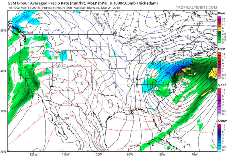
GFS was still way south, CMC is a dream godzilla with up to 20 inches but since when have we started talking bout the CMC lol

jmanley32- Senior Enthusiast

- Posts : 20648
Reputation : 108
Join date : 2013-12-12
Age : 43
Location : Yonkers, NY
 Re: Winter's Finale: March 20th-21st Snowstorm
Honestly at this stage I trust the GFS about as much as I trust the CMC or GGEM
Guest- Guest
 Re: Winter's Finale: March 20th-21st Snowstorm
Yep, this would work.


CPcantmeasuresnow- Wx Statistician Guru

- Posts : 7289
Reputation : 230
Join date : 2013-01-07
Age : 103
Location : Eastern Orange County, NY
 Re: Winter's Finale: March 20th-21st Snowstorm
Only model showing it, since when do we hold the cmc and watch for trends towards it lolCPcantmeasuresnow wrote:Yep, this would work.

jmanley32- Senior Enthusiast

- Posts : 20648
Reputation : 108
Join date : 2013-12-12
Age : 43
Location : Yonkers, NY
 Re: Winter's Finale: March 20th-21st Snowstorm
jmanley32 wrote:Only model showing it, since when do we hold the cmc and watch for trends towards it lolCPcantmeasuresnow wrote:Yep, this would work.
Nothings that far off Jman, still plenty of time especially for Wave 2 if there is a wave 2 and it doesn't end up being one storm instead of 2 separate waves.
I can understand your skepticism you have been burned pretty badly this month with the first 3.

CPcantmeasuresnow- Wx Statistician Guru

- Posts : 7289
Reputation : 230
Join date : 2013-01-07
Age : 103
Location : Eastern Orange County, NY
 Re: Winter's Finale: March 20th-21st Snowstorm
Well nws took down all hwo that have been up for days. That says a lot.

jmanley32- Senior Enthusiast

- Posts : 20648
Reputation : 108
Join date : 2013-12-12
Age : 43
Location : Yonkers, NY
 Re: Winter's Finale: March 20th-21st Snowstorm
jmanley32 wrote:Well nws took down all hwo that have been up for days. That says a lot.
Look at GEFS, Jman. And those HWO come and go with no rhyme or reason, we know this.

SoulSingMG- Senior Enthusiast

- Posts : 2853
Reputation : 74
Join date : 2013-12-11
Location : Long Island City, NY
 Re: Winter's Finale: March 20th-21st Snowstorm
Euro is a tick north with 2nd low. Maybe there's hope.

jmanley32- Senior Enthusiast

- Posts : 20648
Reputation : 108
Join date : 2013-12-12
Age : 43
Location : Yonkers, NY
 Re: Winter's Finale: March 20th-21st Snowstorm
Seems like the temperature forecast for the Shore has improved a lot lately. After this afternoon, even our daytime highs might stay in the 30's!
That's what you like to see if you want snow! Well, that and a storm...
That's what you like to see if you want snow! Well, that and a storm...
SENJsnowman- Senior Enthusiast

- Posts : 1202
Reputation : 61
Join date : 2017-01-06
Age : 51
Location : Long Branch, NJ
 Re: Winter's Finale: March 20th-21st Snowstorm
Good Morning. Regarding wave 1 it looks like we are forming a consensus on where and what at H5.
Later today into tonight the energy that is wave one will be traversing the Rockies on an ENE trajectory.

Once on the eastern side of the continental divide it spins up into a potent bundle of energy that actually closes off 500mb by about 10-12z Monday. Recall prev conversations about whether this energy remaining a "bowling ball of energy" that conts east or does it weaken as it conts east.

As the energy conts ENE you can see below the main vorticity for the first wave passes over Kentucky by approx. 06z Tuesday, but notice we are no longer closed off. You can see NAM GFS and Euro agree on placement and intensity around this time. The problem is as it cont on an ENE trajectory it begins to run into very potent confluence stubbornly placed over the NE. This weakens our vort max, and begin to shear it out and steer deflect it due E from there.


There is only so much latitude that this system can gain due to the confluence in the NE and a fairly muted PNA ridge as it approaches the coast. BUT the PNA is trying to gain amplitude as wave 2 conts east. IF we cont to see favorable trends in the PNA region from Tuesday into Wed, then hopefully wee see the energy consolidate at its base. If it does a more amplified soln here would raise heights along the coast, tilt the trough neg sooner and we all would still have a chance at Wave 2, esp if the spacing between wave 1 and 2 is adequate......, but there isn't a ton of time left.

Regarding wave 1 While I suppose we arent quite at no chance for areas north, I think only the area within the circle has the best chance to see accumulation from wav 1. The confluence simply looks too strong for the precip to make it much further N than this. That said I said we likely wont see the true soln until at least Monday so we'll see what happens. We must see the energy stay strong longer, shift N a little as we go through today and tomorrow, and see the confluence shift N a little.

Later today into tonight the energy that is wave one will be traversing the Rockies on an ENE trajectory.

Once on the eastern side of the continental divide it spins up into a potent bundle of energy that actually closes off 500mb by about 10-12z Monday. Recall prev conversations about whether this energy remaining a "bowling ball of energy" that conts east or does it weaken as it conts east.

As the energy conts ENE you can see below the main vorticity for the first wave passes over Kentucky by approx. 06z Tuesday, but notice we are no longer closed off. You can see NAM GFS and Euro agree on placement and intensity around this time. The problem is as it cont on an ENE trajectory it begins to run into very potent confluence stubbornly placed over the NE. This weakens our vort max, and begin to shear it out and steer deflect it due E from there.


There is only so much latitude that this system can gain due to the confluence in the NE and a fairly muted PNA ridge as it approaches the coast. BUT the PNA is trying to gain amplitude as wave 2 conts east. IF we cont to see favorable trends in the PNA region from Tuesday into Wed, then hopefully wee see the energy consolidate at its base. If it does a more amplified soln here would raise heights along the coast, tilt the trough neg sooner and we all would still have a chance at Wave 2, esp if the spacing between wave 1 and 2 is adequate......, but there isn't a ton of time left.

Regarding wave 1 While I suppose we arent quite at no chance for areas north, I think only the area within the circle has the best chance to see accumulation from wav 1. The confluence simply looks too strong for the precip to make it much further N than this. That said I said we likely wont see the true soln until at least Monday so we'll see what happens. We must see the energy stay strong longer, shift N a little as we go through today and tomorrow, and see the confluence shift N a little.

_________________
"In weather and in life, there's no winning and losing; there's only winning and learning."
WINTER 2012/2013 TOTALS 43.65"WINTER 2017/2018 TOTALS 62.85" WINTER 2022/2023 TOTALS 4.9"
WINTER 2013/2014 TOTALS 64.85"WINTER 2018/2019 TOTALS 14.25" WINTER 2023/2024 TOTALS 13.1"
WINTER 2014/2015 TOTALS 71.20"WINTER 2019/2020 TOTALS 6.35" WINTER 2024/2025 TOTALS 0.00
WINTER 2015/2016 TOTALS 35.00"WINTER 2020/2021 TOTALS 37.75"
WINTER 2016/2017 TOTALS 42.25"WINTER 2021/2022 TOTALS 31.65"

sroc4- Admin

- Posts : 8463
Reputation : 302
Join date : 2013-01-07
Location : Wading River, LI
 Re: Winter's Finale: March 20th-21st Snowstorm
great analysis but I'm losing hope in this fast. Too many things working against it. We will see.sroc4 wrote:Good Morning. Regarding wave 1 it looks like we are forming a consensus on where and what at H5.
Later today into tonight the energy that is wave one will be traversing the Rockies on an ENE trajectory.
Once on the eastern side of the continental divide it spins up into a potent bundle of energy that actually closes off 500mb by about 10-12z Monday. Recall prev conversations about whether this energy remaining a "bowling ball of energy" that conts east or does it weaken as it conts east.
As the energy conts ENE you can see below the main vorticity for the first wave passes over Kentucky by approx. 06z Tuesday, but notice we are no longer closed off. You can see NAM GFS and Euro agree on placement and intensity around this time. The problem is as it cont on an ENE trajectory it begins to run into very potent confluence stubbornly placed over the NE. This weakens our vort max, and begin to shear it out and steer deflect it due E from there.
There is only so much latitude that this system can gain due to the confluence in the NE and a fairly muted PNA ridge as it approaches the coast. BUT the PNA is trying to gain amplitude as wave 2 conts east. IF we cont to see favorable trends in the PNA region from Tuesday into Wed, then hopefully wee see the energy consolidate at its base. If it does a more amplified soln here would raise heights along the coast, tilt the trough neg sooner and we all would still have a chance at Wave 2, esp if the spacing between wave 1 and 2 is adequate......, but there isn't a ton of time left.
Regarding wave 1 While I suppose we arent quite at no chance for areas north, I think only the area within the circle has the best chance to see accumulation from wav 1. The confluence simply looks too strong for the precip to make it much further N than this. That said I said we likely wont see the true soln until at least Monday so we'll see what happens. We must see the energy stay strong longer, shift N a little as we go through today and tomorrow, and see the confluence shift N a little.

jmanley32- Senior Enthusiast

- Posts : 20648
Reputation : 108
Join date : 2013-12-12
Age : 43
Location : Yonkers, NY
 Re: Winter's Finale: March 20th-21st Snowstorm
Sroc. Now I get the picture what we are up against. You make it very understandable even the maps I could follow. Thanks as always
oldtimer- Senior Enthusiast

- Posts : 1103
Reputation : 14
Join date : 2013-01-16
Age : 78
Location : Port Jefferson Station Suffolk County
 Re: Winter's Finale: March 20th-21st Snowstorm
Sroc, do we get a snow or rain storm or can it be a complete miss ?

Artechmetals- Pro Enthusiast

- Posts : 571
Reputation : 3
Join date : 2014-01-01
Age : 57
Location : Wayne , NJ
Page 7 of 29 •  1 ... 6, 7, 8 ... 18 ... 29
Page 7 of 29
Permissions in this forum:
You cannot reply to topics in this forum
 Home
Home


