Winter's Finale: March 20th-21st Snowstorm
+53
dsix85
emokid51783
lglickman1
gigs68
essexcountypete
Smittyaj623
Blaze
dsvinos
aiannone
Nyi1058
Math23x7
Scullybutcher
Taffy
jimv45
Artechmetals
oldtimer
Sanchize06
hurrysundown23
moleson
frank 638
Dunnzoo
hyde345
nujerzeedevil
Snow88
Quietace
SoulSingMG
richb521
adamfitz1969
Radz
GreyBeard
nutleyblizzard
CPcantmeasuresnow
bobjohnsonforthehall
mwilli5783
SNOW MAN
RJB8525
mikeypizano
SENJsnowman
jake732
billg315
dkodgis
Grselig
rb924119
sroc4
WeatherBob
weatherwatchermom
algae888
jmanley32
amugs
docstox12
skinsfan1177
Tzvi732
Frank_Wx
57 posters
Page 8 of 29
Page 8 of 29 •  1 ... 5 ... 7, 8, 9 ... 18 ... 29
 Re: Winter's Finale: March 20th-21st Snowstorm
Sroc. Now I get the picture what we are up against. You make it very understandable even the maps I could follow. Thanks as always
oldtimer- Senior Enthusiast

- Posts : 1103
Join date : 2013-01-16
 Re: Winter's Finale: March 20th-21st Snowstorm
Sroc, do we get a snow or rain storm or can it be a complete miss ?
Artechmetals- Pro Enthusiast

- Posts : 571
Join date : 2014-01-01
 Re: Winter's Finale: March 20th-21st Snowstorm
Wouldn't it be very difficult for wave 2 to come far North bc of wave 1 pulling the baroclonic zone farther south? What we really wanted was one consolidated low

skinsfan1177- Senior Enthusiast

- Posts : 4485
Reputation : 35
Join date : 2013-01-07
Age : 47
Location : Point Pleasant Boro
 Re: Winter's Finale: March 20th-21st Snowstorm
Upton HWO.
The probability for widespread hazardous weather is uncertain, as a
series of low pressure systems passing to the south bring chances of
snow Tuesday into Wednesday. A slight northward trend in the expected
track of either of these lows could lead to significant snowfall,
especially for the New York City metropolitan area and Long Island.
Guest- Guest
Artechmetals- Pro Enthusiast

- Posts : 571
Reputation : 3
Join date : 2014-01-01
Age : 57
Location : Wayne , NJ
 Re: Winter's Finale: March 20th-21st Snowstorm
RGEM
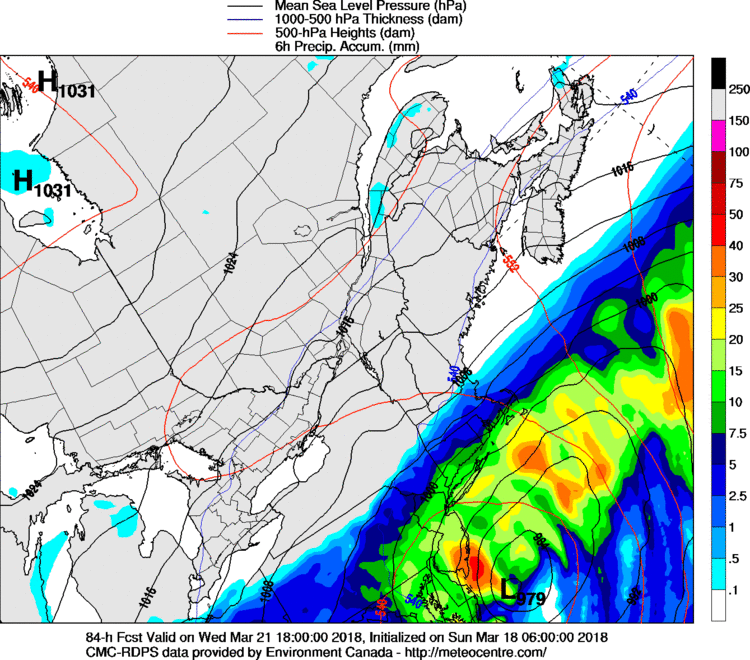
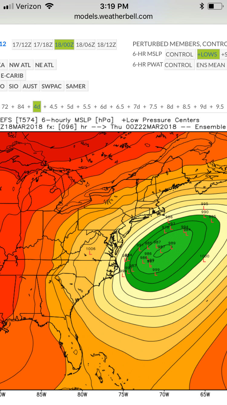
 EPS. The models overnight have trended towards the 2nd wave being the more dominate feature. If the 1st wave can continue to get sheared out in future runs, this will allow the 2nd wave to have room and amplify and come closer to the coast like Sroc mentioned.
nutleyblizzard- Senior Enthusiast

- Posts : 1964
Reputation : 42
Join date : 2014-01-30
Age : 58
Location : Nutley, new jersey
 Re: Winter's Finale: March 20th-21st Snowstorm
skinsfan1177 wrote:Wouldn't it be very difficult for wave 2 to come far North bc of wave 1 pulling the baroclonic zone farther south? What we really wanted was one consolidated low
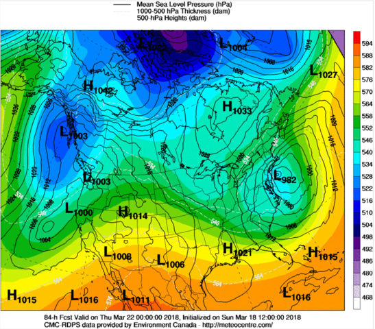
Skins the one consolidated low soln hasn't really been on the table for the past few days. It has become clear that there will be this initial wave followed by a second one. You are correct in sayin that wave one could bring the baroclinic zone too far south IF the wave spacing between the two is too close and or if its too stron. Wave one approaches the coast in an ENE direction due to a muted PNA ridge, and the strong confluence on a NW to SE wind flow. However, if wave one gets out of the way, as you can see the NAM hinting that the area of confluences shifts north and is now more W to E or even slight WSW to ENE. This lifting of the confluence is likely in direct response to the PNA ridge really amplifying in the west. Also as a result of the PNA amplification it looks like it is trying to consolidate the energy at the base of the mean trough. As it rounds the base you can see there is now room for heights to raise along the coast tilting the trough axis towards negative which brings the surface low on a NE trajectory. IF we can get more of this energy to consolidate in successive runs we likely see the trough tilt more neg and see the Low come right up the coast as long as it does so before the trough axis is too far east. How this all happens will be dictated by:
1) Wave spacing between wave 1 and 2. If the first wave is too close, OR too strong it will not allow for height rises in front of wave 2. So if we want wave 2 to work out, a sheared out wave 1 is actually better IMO. That still doesn't mean the weaker more strung out initial wave cant or wont trend N a little more and we still get snow from it.
2) We need to see the PNA ridge trend more and more amplified and the confluence zone shift north to create room for the height rises along the coast if
3) we can consolidate all the energy at the base of the mean trough, see it round the base and tilt the trough neg in time before the trough axis gets to far east.


_________________
"In weather and in life, there's no winning and losing; there's only winning and learning."
WINTER 2012/2013 TOTALS 43.65"WINTER 2017/2018 TOTALS 62.85" WINTER 2022/2023 TOTALS 4.9"
WINTER 2013/2014 TOTALS 64.85"WINTER 2018/2019 TOTALS 14.25" WINTER 2023/2024 TOTALS 13.1"
WINTER 2014/2015 TOTALS 71.20"WINTER 2019/2020 TOTALS 6.35" WINTER 2024/2025 TOTALS 0.00
WINTER 2015/2016 TOTALS 35.00"WINTER 2020/2021 TOTALS 37.75"
WINTER 2016/2017 TOTALS 42.25"WINTER 2021/2022 TOTALS 31.65"

sroc4- Admin

- Posts : 8463
Reputation : 302
Join date : 2013-01-07
Location : Wading River, LI
 Re: Winter's Finale: March 20th-21st Snowstorm
Scott great depiction of the issues.
Our heads spinning living by each models op run yet?
The confluence over NE is the main problem as I see it and alluded to in a post Friday.
The PNA ridge losing amplification is an issue but not as great as teh issue over the NE.
If that confluence was weaker it would allow the 1st wave to come more north setting the stage of our second wave to follow suite.
Disheartening to a degree since the maps at H5 were showing an absolute bomb of a set up.
Time will tell but the most important aspect right now is where our 1st LP exits off the east coast. If it it off the Delmarva we should be okay for teh second one to come up teh coast since the PAN looks to regain itself and pump the heights. This will also allow the barclonic zone to set up shop for the second storm to ride up teh coast. If it is off the VA/NC coast CNJ will be the most or cut off for the snow I 195 and south type
One thing I have witnessed over my years of tracking storm when TV pro mets start harping on a storm in advance it rarely works out.
Lastly if the 1st wave get sheared to shreds over say Kentucky then the stage could be set for a big storm with teh 2nd LP since it will not dampen the heights off the EC and allow the atmosphere to recover faster here and let the 2nd storm climb the coast with the PNA ridge building and the Confluence starting to lessen.
Off to the pearl river st paddys parade - part two this weekend - be back tonight.
_________________
Mugs
AKA:King: Snow Weenie
Self Proclaimed
WINTER 2014-15 : 55.12" +.02 for 6 coatings (avg. 35")
WINTER 2015-16 Total - 29.8" (Avg 35")
WINTER 2016-17 : 39.5" so far

amugs- Advanced Forecaster - Mod

- Posts : 15160
Reputation : 213
Join date : 2013-01-07
Age : 54
Location : Hillsdale,NJ
 Re: Winter's Finale: March 20th-21st Snowstorm
sroc4 wrote:skinsfan1177 wrote:Wouldn't it be very difficult for wave 2 to come far North bc of wave 1 pulling the baroclonic zone farther south? What we really wanted was one consolidated low
Skins the one consolidated low soln hasn't really been on the table for the past few days. It has become clear that there will be this initial wave followed by a second one. You are correct in sayin that wave one could bring the baroclinic zone too far south IF the wave spacing between the two is too close and or if its too stron. Wave one approaches the coast in an ENE direction due to a muted PNA ridge, and the strong confluence on a NW to SE wind flow. However, if wave one gets out of the way, as you can see the NAM hinting that the area of confluences shifts north and is now more W to E or even slight WSW to ENE. This lifting of the confluence is likely in direct response to the PNA ridge really amplifying in the west. Also as a result of the PNA amplification it looks like it is trying to consolidate the energy at the base of the mean trough. As it rounds the base you can see there is now room for heights to raise along the coast tilting the trough axis towards negative which brings the surface low on a NE trajectory. IF we can get more of this energy to consolidate in successive runs we likely see the trough tilt more neg and see the Low come right up the coast as long as it does so before the trough axis is too far east. How this all happens will be dictated by:
1) Wave spacing between wave 1 and 2. If the first wave is too close, OR too strong it will not allow for height rises in front of wave 2. So if we want wave 2 to work out, a sheared out wave 1 is actually better IMO. That still doesn't mean the weaker more strung out initial wave cant or wont trend N a little more and we still get snow from it.
2) We need to see the PNA ridge trend more and more amplified and the confluence zone shift north to create room for the height rises along the coast if
3) we can consolidate all the energy at the base of the mean trough, see it round the base and tilt the trough neg in time before the trough axis gets to far east.
Great explanation sroc. Maybe we can still get wave 1 and 2 to come tgether

skinsfan1177- Senior Enthusiast

- Posts : 4485
Reputation : 35
Join date : 2013-01-07
Age : 47
Location : Point Pleasant Boro
 Re: Winter's Finale: March 20th-21st Snowstorm
Midday runs of NAM and GFS are nice storms from WVa east to Virginia and Delmarva, SNJ may see some action yet, all west-east flow, no northern turn until ots...
_________________
Janet
Snowfall winter of 2023-2024 17.5"
Snowfall winter of 2022-2023 6.0"
Snowfall winter of 2021-2022 17.6" 1" sleet 2/25/22
Snowfall winter of 2020-2021 51.1"
Snowfall winter of 2019-2020 8.5"
Snowfall winter of 2018-2019 25.1"
Snowfall winter of 2017-2018 51.9"
Snowfall winter of 2016-2017 45.6"
Snowfall winter of 2015-2016 29.5"
Snowfall winter of 2014-2015 50.55"
Snowfall winter of 2013-2014 66.5"
Dunnzoo- Senior Enthusiast - Mod

- Posts : 4939
Reputation : 68
Join date : 2013-01-11
Age : 62
Location : Westwood, NJ

skinsfan1177- Senior Enthusiast

- Posts : 4485
Reputation : 35
Join date : 2013-01-07
Age : 47
Location : Point Pleasant Boro
 Re: Winter's Finale: March 20th-21st Snowstorm
That second low really bombs out and is a near miss, maybe theres some way we can get it in closer? GFS was actually a tick west and gets precip into cape now but keeps everything south of LI, CMC is back south last night was a tease most likely.

jmanley32- Senior Enthusiast

- Posts : 20648
Reputation : 108
Join date : 2013-12-12
Age : 43
Location : Yonkers, NY
 Re: Winter's Finale: March 20th-21st Snowstorm
Well its certainly dead and wheres Frank, I am curious if index is go be lowered and his analysis of situation. He italian not Irish lol

jmanley32- Senior Enthusiast

- Posts : 20648
Reputation : 108
Join date : 2013-12-12
Age : 43
Location : Yonkers, NY
 Re: Winter's Finale: March 20th-21st Snowstorm
Guessing that would be a huge hit.skinsfan1177 wrote:RGEM

jmanley32- Senior Enthusiast

- Posts : 20648
Reputation : 108
Join date : 2013-12-12
Age : 43
Location : Yonkers, NY
 Re: Winter's Finale: March 20th-21st Snowstorm
I THINK THE RGEM HAS BEEN SHOWN TO HAVE MERIT, AT LEAST WITH RESPECT TO TODAY'S 12z RUNS. NAM looked worse, CMC/GFS HELD SERVE, BUT THE UK AND NOW THE EURO WITH A TREMENDOUS SHIFT WEST. WE ARE SO CLOSE HERE PEOPLE, ONE MORE SPIKE IN THE PNA RIDGE WE GET WALLOPED!!!!!!! ENSEMBLES SHOULD BE MIGHTY INTERESTING LATER!!!! WOOOOOOOOOOOOOOOOOOOOOOOOOOOOOO!!!!! TODAYS ADJUSTMENTS FIT THE PATTERN, SO LETS SEE WHERE WE GO FROM HERE!!!!
rb924119- Meteorologist

- Posts : 7119
Reputation : 195
Join date : 2013-02-06
Age : 32
Location : Greentown, Pa
 Re: Winter's Finale: March 20th-21st Snowstorm
Another option is to slow our lead wave. Combine the additional PNA spike and slow down of the lead wave and we measure in yardsticks. SO SO SO SO SO SO CLOSE!!!!
rb924119- Meteorologist

- Posts : 7119
Reputation : 195
Join date : 2013-02-06
Age : 32
Location : Greentown, Pa
 Re: Winter's Finale: March 20th-21st Snowstorm
Warning criteria snow from NYC southwest through Allentown, Pa and Harrisburg, Pa verbatim on the EURO Op.
rb924119- Meteorologist

- Posts : 7119
Reputation : 195
Join date : 2013-02-06
Age : 32
Location : Greentown, Pa
 Re: Winter's Finale: March 20th-21st Snowstorm
snowmap please.rb924119 wrote:Warning criteria snow from NYC southwest through Allentown, Pa and Harrisburg, Pa verbatim on the EURO Op.

nutleyblizzard- Senior Enthusiast

- Posts : 1964
Reputation : 42
Join date : 2014-01-30
Age : 58
Location : Nutley, new jersey
 Re: Winter's Finale: March 20th-21st Snowstorm
rb924119 wrote:Another option is to slow our lead wave. Combine the additional PNA spike and slow down of the lead wave and we measure in yardsticks. SO SO SO SO SO SO CLOSE!!!!
Yup. Euro seems to shred out the initial wave early never really deleoping a distinct surface low. Instead PNA spike follows and second wave develops primary that comes really freaking close.
Btw. Why does everyone always worry about where Frank is. He has been on and off all season. He’s a busy man.
_________________
"In weather and in life, there's no winning and losing; there's only winning and learning."
WINTER 2012/2013 TOTALS 43.65"WINTER 2017/2018 TOTALS 62.85" WINTER 2022/2023 TOTALS 4.9"
WINTER 2013/2014 TOTALS 64.85"WINTER 2018/2019 TOTALS 14.25" WINTER 2023/2024 TOTALS 13.1"
WINTER 2014/2015 TOTALS 71.20"WINTER 2019/2020 TOTALS 6.35" WINTER 2024/2025 TOTALS 0.00
WINTER 2015/2016 TOTALS 35.00"WINTER 2020/2021 TOTALS 37.75"
WINTER 2016/2017 TOTALS 42.25"WINTER 2021/2022 TOTALS 31.65"

sroc4- Admin

- Posts : 8463
Reputation : 302
Join date : 2013-01-07
Location : Wading River, LI
 Re: Winter's Finale: March 20th-21st Snowstorm
sroc4 wrote:rb924119 wrote:Another option is to slow our lead wave. Combine the additional PNA spike and slow down of the lead wave and we measure in yardsticks. SO SO SO SO SO SO CLOSE!!!!
Yup. Euro seems to shred out the initial wave early never really deleoping a distinct surface low. Instead PNA spike follows and second wave develops primary that comes really freaking close.
Btw. Why does everyone always worry about where Frank is. He has been on and off all season. He’s a busy man.
I'd really like to see the lead wave slow and end up further north, too, as that would not only help the following system come closer, but also increase the chances of the highly elusive triple phase, rarely seen by snow weenies aside from dreams and hand drawn maps lmao
rb924119- Meteorologist

- Posts : 7119
Reputation : 195
Join date : 2013-02-06
Age : 32
Location : Greentown, Pa
 Re: Winter's Finale: March 20th-21st Snowstorm
nutleyblizzard wrote:snowmap please.rb924119 wrote:Warning criteria snow from NYC southwest through Allentown, Pa and Harrisburg, Pa verbatim on the EURO Op.

rb924119- Meteorologist

- Posts : 7119
Reputation : 195
Join date : 2013-02-06
Age : 32
Location : Greentown, Pa
 Re: Winter's Finale: March 20th-21st Snowstorm
UH OH. GOT WORD THAT THE SREFS ARE COMING IN LOCKED, LOADED, AND THEIR TARGET HAS BEEN ACQUIRED - NJ STRONG PUT YOUR UNIFORMS ON AND GRAB YOUR HELMETS BECAUSE THE FIGHT JUST BEEN TAKEN TO US
rb924119- Meteorologist

- Posts : 7119
Reputation : 195
Join date : 2013-02-06
Age : 32
Location : Greentown, Pa
 Re: Winter's Finale: March 20th-21st Snowstorm
rb924119 wrote:UH OH. GOT WORD THAT THE SREFS ARE COMING IN LOCKED, LOADED, AND THEIR TARGET HAS BEEN ACQUIRED - NJ STRONG PUT YOUR UNIFORMS ON AND GRAB YOUR HELMETS BECAUSE THE FIGHT JUST BEEN TAKEN TO US
hey just popped on to see what's up.. trying not to get any hopes up....you are in all caps again today....but listen to me young man!! you better not leave us hangin...or this mamma is coming for you


weatherwatchermom- Senior Enthusiast

- Posts : 3897
Reputation : 78
Join date : 2014-11-25
Location : Hazlet Township, NJ
 Re: Winter's Finale: March 20th-21st Snowstorm
00z GEFS vs 12z


_________________
"In weather and in life, there's no winning and losing; there's only winning and learning."
WINTER 2012/2013 TOTALS 43.65"WINTER 2017/2018 TOTALS 62.85" WINTER 2022/2023 TOTALS 4.9"
WINTER 2013/2014 TOTALS 64.85"WINTER 2018/2019 TOTALS 14.25" WINTER 2023/2024 TOTALS 13.1"
WINTER 2014/2015 TOTALS 71.20"WINTER 2019/2020 TOTALS 6.35" WINTER 2024/2025 TOTALS 0.00
WINTER 2015/2016 TOTALS 35.00"WINTER 2020/2021 TOTALS 37.75"
WINTER 2016/2017 TOTALS 42.25"WINTER 2021/2022 TOTALS 31.65"

sroc4- Admin

- Posts : 8463
Reputation : 302
Join date : 2013-01-07
Location : Wading River, LI
 Re: Winter's Finale: March 20th-21st Snowstorm
EPS 4-8" ALONG I-95!!!!! TREMENDOUS NORTHWESTWARD SHIFT!!!!!!
rb924119- Meteorologist

- Posts : 7119
Reputation : 195
Join date : 2013-02-06
Age : 32
Location : Greentown, Pa
 Re: Winter's Finale: March 20th-21st Snowstorm
SREFS JUST WENT THOR AND DROPPED MJOLNIR ON US DEAR LORD
rb924119- Meteorologist

- Posts : 7119
Reputation : 195
Join date : 2013-02-06
Age : 32
Location : Greentown, Pa
 Re: Winter's Finale: March 20th-21st Snowstorm
Rb looks like as of now south of us, but these things can always change.
jimv45- Senior Enthusiast

- Posts : 1168
Reputation : 36
Join date : 2013-09-20
Location : Hopewell jct.
Page 8 of 29 •  1 ... 5 ... 7, 8, 9 ... 18 ... 29
Page 8 of 29
Permissions in this forum:
You cannot reply to topics in this forum
 Home
Home