Back to Back Snow Events FEB 9th-11th
+35
phil155
SNOW MAN
skinsfan1177
algae888
brownie
Vinnydula
essexcountypete
weatherwatchermom
DAYBLAZER
1190ftalt
Artingerb
CnWestMilford76
kalleg
Math23x7
2004blackwrx
bobjohnsonforthehall
Dunnzoo
docstox12
oldtimer
lglickman1
sroc4
hyde345
CPcantmeasuresnow
Snow88
frank 638
nutleyblizzard
Irish
aiannone
SENJsnowman
heehaw453
amugs
dsix85
billg315
jmanley32
Frank_Wx
39 posters
Page 1 of 12
Page 1 of 12 • 1, 2, 3 ... 10, 11, 12 
 Back to Back Snow Events FEB 9th-11th
There are a couple of shots for more snowfall on Tuesday and Thursday next week. Let’s use this thread to discuss and analyze those events.
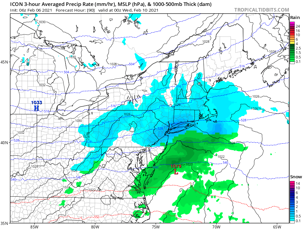
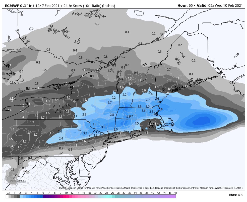
The one on Tuesday resembles a clipper-style that doesn’t have a very high ceiling. Fast moving clippers generally have a max of 3-6 inches. The GFS tracks this clipper north of the area which results in rain for NYC and south, while the ICON has it going south of us which keeps us all cold enough to snow.


Notice with the 500mb map how the strongest PvA is north of our area on Tuesday afternoon. The Polar Vortex is near the Hudson Bay and trying to press down to the SE. This “press” is essential because it combats the SE Ridge and keeps our area below freezing. But the GFS isn’t feeling the press, so the storm finds a path of least resistance that is NW of us. The NAM agrees with the GFS. The CMC tracks the low right over NYC and the ICON (shown above) is the furthest south. My guess is the PV is actually too far NW, which gives room for this clipper to track NW and bring most of us a very light rainfall. However, low level cold may still be intact for area NW of NYC to see a couple of inches.
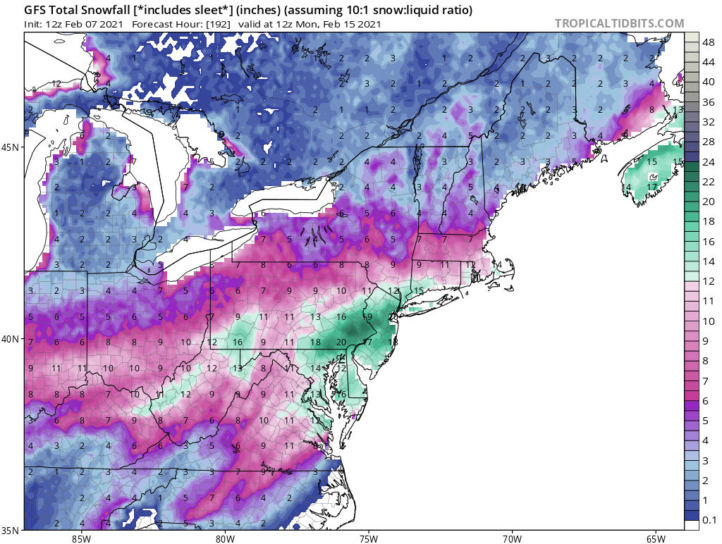
The possible storm two days later is a different animal. This one sees the aforementioned Polar Vortex drop south near the US/Canada border. A strong piece of upper level energy ejects out of the SW CONUS and marches toward our area. With confluence and the PV to the north, there may not be room for it to cut. If it does, a secondary low may try to form off the coast. Sound familiar? It should, because that’s what occurred with the Roidzilla storm.
This threat remains a bit away and models can’t get a handle on the PV. If the PV is too far north then the SE ridge flexes. Once that happens the storm is likely to cut to our west and we all warm up. Also, models show the PV elongating across the US-CAN border. There is confluence in New England, but again, is it enough? These questions won’t get answered until the final days leading up to the storm. All we can do is monitor trends this weekend then on Monday we’ll begin looking deeper at the pattern.
The one on Tuesday resembles a clipper-style that doesn’t have a very high ceiling. Fast moving clippers generally have a max of 3-6 inches. The GFS tracks this clipper north of the area which results in rain for NYC and south, while the ICON has it going south of us which keeps us all cold enough to snow.


Notice with the 500mb map how the strongest PvA is north of our area on Tuesday afternoon. The Polar Vortex is near the Hudson Bay and trying to press down to the SE. This “press” is essential because it combats the SE Ridge and keeps our area below freezing. But the GFS isn’t feeling the press, so the storm finds a path of least resistance that is NW of us. The NAM agrees with the GFS. The CMC tracks the low right over NYC and the ICON (shown above) is the furthest south. My guess is the PV is actually too far NW, which gives room for this clipper to track NW and bring most of us a very light rainfall. However, low level cold may still be intact for area NW of NYC to see a couple of inches.
The possible storm two days later is a different animal. This one sees the aforementioned Polar Vortex drop south near the US/Canada border. A strong piece of upper level energy ejects out of the SW CONUS and marches toward our area. With confluence and the PV to the north, there may not be room for it to cut. If it does, a secondary low may try to form off the coast. Sound familiar? It should, because that’s what occurred with the Roidzilla storm.
This threat remains a bit away and models can’t get a handle on the PV. If the PV is too far north then the SE ridge flexes. Once that happens the storm is likely to cut to our west and we all warm up. Also, models show the PV elongating across the US-CAN border. There is confluence in New England, but again, is it enough? These questions won’t get answered until the final days leading up to the storm. All we can do is monitor trends this weekend then on Monday we’ll begin looking deeper at the pattern.
_________________
_______________________________________________________________________________________________________
CLICK HERE to view NJ Strong Snowstorm Classifications
 Re: Back to Back Snow Events FEB 9th-11th
Wow, this is like a REAL winter lol 3 potential storms in one week. So 4-8 tomorrow, possibly 3-6 midweek and then a potential for a big storm, we will be buried, havent seen that in ages, lets say that the 3rd storm ends up being a monster if i saw another 20 inches of snow this would rival the biggest snow since ive been on this board, that would be amazing even if its small my totals are climbing steadily to the top 2 or 3..

jmanley32- Senior Enthusiast

- Posts : 20645
Reputation : 108
Join date : 2013-12-12
Age : 43
Location : Yonkers, NY
 Re: Back to Back Snow Events FEB 9th-11th
Very active pattern and plenty of cold air which is good. But let's temper expectations just a bit to keep anyone from being disappointed. Frank said clippers generally have a "max" upside of 3-6"; "max" is a key word there. In this case Frank points out some models show a "warmer" track (more rain) and even if it takes a track to our south there's no guarantee with a clipper that we get that "max" upside. Often we get less. The Tuesday system might at best be a 2-4" event and maybe just a slop-fest. So we'll have to see what the next 24 hours holds on the model runs.
But definitely a lot to track in the coming week.
But definitely a lot to track in the coming week.

billg315- Advanced Forecaster - Mod

- Posts : 4555
Reputation : 185
Join date : 2015-01-24
Age : 50
Location : Flemington, NJ
 Re: Back to Back Snow Events FEB 9th-11th
Frank- when does the sun angle start being a factor during these storms?
dsix85- Pro Enthusiast

- Posts : 351
Reputation : 8
Join date : 2014-01-01
Location : New York
 Re: Back to Back Snow Events FEB 9th-11th
Yeah it was totally a what if statement i made, but the fact that we are tracking so much,billg315 wrote:Very active pattern and plenty of cold air which is good. But let's temper expectations just a bit to keep anyone from being disappointed. Frank said clippers generally have a "max" upside of 3-6"; "max" is a key word there. In this case Frank points out some models show a "warmer" track (more rain) and even if it takes a track to our south there's no guarantee with a clipper that we get that "max" upside. Often we get less. The Tuesday system might at best be a 2-4" event and maybe just a slop-fest. So we'll have to see what the next 24 hours holds on the model runs.
But definitely a lot to track in the coming week.

jmanley32- Senior Enthusiast

- Posts : 20645
Reputation : 108
Join date : 2013-12-12
Age : 43
Location : Yonkers, NY
 Re: Back to Back Snow Events FEB 9th-11th
dsix85 wrote:Frank- when does the sun angle start being a factor during these storms?
Hopefully soon. I’m ready for spring lol.
Guest- Guest
 Re: Back to Back Snow Events FEB 9th-11th
Clippers love to make the I78 run or I80 run tjis time of year.
Coastals like to ride the boundary that is there between cold air and warmer ocean temps.
Listen we have Tuesday, Thursday, Friday and next Tuesday. This pattern may just may set up for another monster towards a relaxation( keep that in mind)
Coastals like to ride the boundary that is there between cold air and warmer ocean temps.
Listen we have Tuesday, Thursday, Friday and next Tuesday. This pattern may just may set up for another monster towards a relaxation( keep that in mind)
_________________
Mugs
AKA:King: Snow Weenie
Self Proclaimed
WINTER 2014-15 : 55.12" +.02 for 6 coatings (avg. 35")
WINTER 2015-16 Total - 29.8" (Avg 35")
WINTER 2016-17 : 39.5" so far

amugs- Advanced Forecaster - Mod

- Posts : 15148
Reputation : 213
Join date : 2013-01-07
Age : 54
Location : Hillsdale,NJ
 Re: Back to Back Snow Events FEB 9th-11th
Rooster89 wrote:dsix85 wrote:Frank- when does the sun angle start being a factor during these storms?
Hopefully soon. I’m ready for spring lol.
Rooster usually the 3ed week of Feb 20thh on. But if you have deep arctic air it doesn't matter 2015 and March of 2018 showed this very well besides other times of course.
_________________
Mugs
AKA:King: Snow Weenie
Self Proclaimed
WINTER 2014-15 : 55.12" +.02 for 6 coatings (avg. 35")
WINTER 2015-16 Total - 29.8" (Avg 35")
WINTER 2016-17 : 39.5" so far

amugs- Advanced Forecaster - Mod

- Posts : 15148
Reputation : 213
Join date : 2013-01-07
Age : 54
Location : Hillsdale,NJ
 Re: Back to Back Snow Events FEB 9th-11th
As long as it starts to warm up and yard sales start (this is my side husstle while I look for new full time work (laid off due to covid and not hired back), I buy and resell on ebay and FB market, it quite lucrative if you have the experience and time I have) in mid to late march I am good, meanwhile bring on the winter.

jmanley32- Senior Enthusiast

- Posts : 20645
Reputation : 108
Join date : 2013-12-12
Age : 43
Location : Yonkers, NY
 Re: Back to Back Snow Events FEB 9th-11th
If you are fortunate enough to stay below the baroclinic zone in the next 4/5 days, then you are going to be getting a lot of snow. It will set up anywhere from LHV to Mason Dixon Line IMO. Not possible to pinpoint at this range.
heehaw453- Advanced Forecaster

- Posts : 3931
Reputation : 86
Join date : 2014-01-20
Location : Bedminster Township, PA Elevation 600' ASL
SENJsnowman likes this post
 Re: Back to Back Snow Events FEB 9th-11th
heehaw453 wrote:If you are fortunate enough to stay below the baroclinic zone in the next 4/5 days, then you are going to be getting a lot of snow. It will set up anywhere from LHV to Mason Dixon Line IMO. Not possible to pinpoint at this range.
Anyone know a place where I can at least place a bet on EXACTLY where that line sets up! lol!!
SENJsnowman- Senior Enthusiast

- Posts : 1198
Reputation : 61
Join date : 2017-01-06
Age : 51
Location : Long Branch, NJ
 Re: Back to Back Snow Events FEB 9th-11th
SENJsnowman wrote:heehaw453 wrote:If you are fortunate enough to stay below the baroclinic zone in the next 4/5 days, then you are going to be getting a lot of snow. It will set up anywhere from LHV to Mason Dixon Line IMO. Not possible to pinpoint at this range.
Anyone know a place where I can at least place a bet on EXACTLY where that line sets up! lol!!

You know I'd much rather be on the arctic boundary than on the very cold side of it. Deep in the arctic side won't be in the game for winter storms. Our area is at least in the game and not just one threat. But yes it will be great to be on the cold side of it! I don't want a lot of ice and that is a risk too.
heehaw453- Advanced Forecaster

- Posts : 3931
Reputation : 86
Join date : 2014-01-20
Location : Bedminster Township, PA Elevation 600' ASL
SENJsnowman likes this post
 Re: Back to Back Snow Events FEB 9th-11th
Tuesday for a nice little refresher anyone? Like a nice G&T with a lime..wedge or T & S with a few twists of lemon??


_________________
Mugs
AKA:King: Snow Weenie
Self Proclaimed
WINTER 2014-15 : 55.12" +.02 for 6 coatings (avg. 35")
WINTER 2015-16 Total - 29.8" (Avg 35")
WINTER 2016-17 : 39.5" so far

amugs- Advanced Forecaster - Mod

- Posts : 15148
Reputation : 213
Join date : 2013-01-07
Age : 54
Location : Hillsdale,NJ
CPcantmeasuresnow likes this post
 Re: Back to Back Snow Events FEB 9th-11th
_________________
Mugs
AKA:King: Snow Weenie
Self Proclaimed
WINTER 2014-15 : 55.12" +.02 for 6 coatings (avg. 35")
WINTER 2015-16 Total - 29.8" (Avg 35")
WINTER 2016-17 : 39.5" so far

amugs- Advanced Forecaster - Mod

- Posts : 15148
Reputation : 213
Join date : 2013-01-07
Age : 54
Location : Hillsdale,NJ

jmanley32- Senior Enthusiast

- Posts : 20645
Reputation : 108
Join date : 2013-12-12
Age : 43
Location : Yonkers, NY
elkiehound likes this post
 Re: Back to Back Snow Events FEB 9th-11th
KEEP THE PACK. We can wait to add on thursday. For now, as long as Tuesday isnt heavy rain, ill take whatever,
_________________
-Alex Iannone-

aiannone- Senior Enthusiast - Mod

- Posts : 4827
Reputation : 92
Join date : 2013-01-07
Location : Saint James, LI (Northwest Suffolk Co.)
 Re: Back to Back Snow Events FEB 9th-11th
I'm seeing snow from Wednesday through Friday morning, early calls are saying 6-12.

Irish- Pro Enthusiast

- Posts : 788
Reputation : 19
Join date : 2019-01-16
Age : 46
Location : Old Bridge, NJ
 Re: Back to Back Snow Events FEB 9th-11th
Irish wrote:I'm seeing snow from Wednesday through Friday morning, early calls are saying 6-12.
It will depend on where the baroclinic zone sets up. Whoever is in the sweet spot will probably approach 1' of snow. The moisture will ride that pathway like a train on a rail. A few years back Boston was in the sweet spot for about 1 month and received 100" of snow.
heehaw453- Advanced Forecaster

- Posts : 3931
Reputation : 86
Join date : 2014-01-20
Location : Bedminster Township, PA Elevation 600' ASL
 Re: Back to Back Snow Events FEB 9th-11th
I updated the SCI - man this is going to be another wild week
_________________
_______________________________________________________________________________________________________
CLICK HERE to view NJ Strong Snowstorm Classifications
heehaw453 likes this post
 Re: Back to Back Snow Events FEB 9th-11th
Keep it coming we’re on an absolute roll right now. There’s no telling when we might get this favorable pattern again.Frank_Wx wrote:I updated the SCI - man this is going to be another wild week

nutleyblizzard- Senior Enthusiast

- Posts : 1963
Reputation : 41
Join date : 2014-01-30
Age : 58
Location : Nutley, new jersey
 Re: Back to Back Snow Events FEB 9th-11th
Frank_Wx wrote:I updated the SCI - man this is going to be another wild week
Euro is furthest south with Tuesday and keeps most of the area snow. Nam is furthest north And is rain for most of this board south of 95 in CT. Gfs is somewhat in the middle. Let’s see if we can keep this all frozen.
_________________
-Alex Iannone-

aiannone- Senior Enthusiast - Mod

- Posts : 4827
Reputation : 92
Join date : 2013-01-07
Location : Saint James, LI (Northwest Suffolk Co.)
SENJsnowman likes this post
 Re: Back to Back Snow Events FEB 9th-11th
18z NAM Tuesday


_________________
_______________________________________________________________________________________________________
CLICK HERE to view NJ Strong Snowstorm Classifications
 Re: Back to Back Snow Events FEB 9th-11th
which storm is gonna give up to a foot? The next one looks to be a few inches maybe 4 at most, or do you mean all combined? This is nuts I haven't seen a scene like this in years.heehaw453 wrote:Irish wrote:I'm seeing snow from Wednesday through Friday morning, early calls are saying 6-12.
It will depend on where the baroclinic zone sets up. Whoever is in the sweet spot will probably approach 1' of snow. The moisture will ride that pathway like a train on a rail. A few years back Boston was in the sweet spot for about 1 month and received 100" of snow.

jmanley32- Senior Enthusiast

- Posts : 20645
Reputation : 108
Join date : 2013-12-12
Age : 43
Location : Yonkers, NY
 Re: Back to Back Snow Events FEB 9th-11th
LOL I think I can handle a 10th of a inch, sure you want that SCI so high frank? a inch in central park doesn't look to happen on that run.Frank_Wx wrote:18z NAM Tuesday

jmanley32- Senior Enthusiast

- Posts : 20645
Reputation : 108
Join date : 2013-12-12
Age : 43
Location : Yonkers, NY

jmanley32- Senior Enthusiast

- Posts : 20645
Reputation : 108
Join date : 2013-12-12
Age : 43
Location : Yonkers, NY
Page 1 of 12 • 1, 2, 3 ... 10, 11, 12 
Page 1 of 12
Permissions in this forum:
You cannot reply to topics in this forum
 Home
Home

