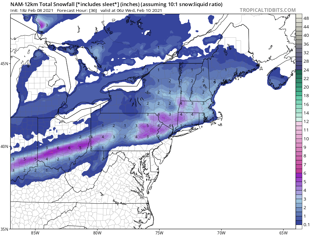
Back to Back Snow Events FEB 9th-11th
+35
phil155
SNOW MAN
skinsfan1177
algae888
brownie
Vinnydula
essexcountypete
weatherwatchermom
DAYBLAZER
1190ftalt
Artingerb
CnWestMilford76
kalleg
Math23x7
2004blackwrx
bobjohnsonforthehall
Dunnzoo
docstox12
oldtimer
lglickman1
sroc4
hyde345
CPcantmeasuresnow
Snow88
frank 638
nutleyblizzard
Irish
aiannone
SENJsnowman
heehaw453
amugs
dsix85
billg315
jmanley32
Frank_Wx
39 posters
Page 3 of 12
Page 3 of 12 •  1, 2, 3, 4 ... 10, 11, 12
 Re: Back to Back Snow Events FEB 9th-11th
Seems to me 3"+ NW of the I95 maybe possible. I don't think NW of I95 is raining. It will be more dependent on how far south the moisture slides IMO.
heehaw453- Advanced Forecaster

- Posts : 3926
Join date : 2014-01-20
 Re: Back to Back Snow Events FEB 9th-11th
GFS is on board for the area - could this actually be righty this time? If so it gains some credibility back. What's the saying "snow begets snow"


amugs- Advanced Forecaster - Mod

- Posts : 15146
Join date : 2013-01-07
 Re: Back to Back Snow Events FEB 9th-11th
so looks like the moidels favor N/W or metro area as the sweet spots, Frank had said 15:1 ratios so shouldnt the totals be sig higher so GFS shows 4 for me, wouldnt it be 6 then at 15:1? Did I do the match right its 1.5x the amount? I am very tired so if I did it wrong someone please remind me but anyways is Franks call factoring in the ratios?
Last edited by jmanley32 on Mon Feb 08, 2021 11:28 am; edited 1 time in total

jmanley32- Senior Enthusiast

- Posts : 20642
Reputation : 108
Join date : 2013-12-12
Age : 43
Location : Yonkers, NY
 Re: Back to Back Snow Events FEB 9th-11th
How does the event at the end of the week look? Is it light snow for a few days, or is there a chance for more significant accumulations?
lglickman1- Pro Enthusiast

- Posts : 319
Reputation : 0
Join date : 2013-02-05
Location : New Rochelle, NY
 Re: Back to Back Snow Events FEB 9th-11th
I think the 14th storm has potential to be a bigger event, correct me if im wrong.lglickman1 wrote:How does the event at the end of the week look? Is it light snow for a few days, or is there a chance for more significant accumulations?

jmanley32- Senior Enthusiast

- Posts : 20642
Reputation : 108
Join date : 2013-12-12
Age : 43
Location : Yonkers, NY
 Re: Back to Back Snow Events FEB 9th-11th
lglickman1 wrote:How does the event at the end of the week look? Is it light snow for a few days, or is there a chance for more significant accumulations?
It is an over running snow event of snow the GFS has backed off the bigger snows its ensembles is showing so we'll have to see once Tuesdays storm get out of the way to be hones. One at a time peeps.
AND I did not see teh 12Z for Thursday into Friday adn now it shows this - from my boy NFSWX - both Koochie Hoochie Maps that Frank has banned BUT The snow ratio are not 10:1 more like 12/15:1 in NNJ adn LHV/HV
Tomorrow morning

Thursday into Friday

_________________
Mugs
AKA:King: Snow Weenie
Self Proclaimed
WINTER 2014-15 : 55.12" +.02 for 6 coatings (avg. 35")
WINTER 2015-16 Total - 29.8" (Avg 35")
WINTER 2016-17 : 39.5" so far

amugs- Advanced Forecaster - Mod

- Posts : 15146
Reputation : 213
Join date : 2013-01-07
Age : 54
Location : Hillsdale,NJ
 Re: Back to Back Snow Events FEB 9th-11th
amugs wrote:lglickman1 wrote:How does the event at the end of the week look? Is it light snow for a few days, or is there a chance for more significant accumulations?
It is an over running snow event of snow the GFS has backed off the bigger snows its ensembles is showing so we'll have to see once Tuesdays storm get out of the way to be hones. One at a time peeps.
AND I did not see teh 12Z for Thursday into Friday adn now it shows this - from my boy NFSWX - both Koochie Hoochie Maps that Frank has banned BUT The snow ratio are not 10:1 more like 12/15:1 in NNJ adn LHV/HV
Tomorrow morning
Thursday into Friday
I'm pretty sure what you posted above is the total snowfall through 7PM Wednesday Mugs, which would really just be tomorrows event. WTS that's pretty aggressive and I'm all in.

CPcantmeasuresnow- Wx Statistician Guru

- Posts : 7281
Reputation : 230
Join date : 2013-01-07
Age : 103
Location : Eastern Orange County, NY
 Re: Back to Back Snow Events FEB 9th-11th
Did you mean to show the map twice? Is one supposed to be tomorrows? And if so can you post tomorrows kooci moochie map lmao thats hilarious.amugs wrote:lglickman1 wrote:How does the event at the end of the week look? Is it light snow for a few days, or is there a chance for more significant accumulations?
It is an over running snow event of snow the GFS has backed off the bigger snows its ensembles is showing so we'll have to see once Tuesdays storm get out of the way to be hones. One at a time peeps.
AND I did not see teh 12Z for Thursday into Friday adn now it shows this - from my boy NFSWX - both Koochie Hoochie Maps that Frank has banned BUT The snow ratio are not 10:1 more like 12/15:1 in NNJ adn LHV/HV
Tomorrow morning
Thursday into Friday

jmanley32- Senior Enthusiast

- Posts : 20642
Reputation : 108
Join date : 2013-12-12
Age : 43
Location : Yonkers, NY
 Re: Back to Back Snow Events FEB 9th-11th
I am sure you are CP lol, yeah im cool with that too but it could scoot south and benefit the metro area and still give you the bulk, im on the cusp of 6" and thats kinda when I consider it a real storm, anything less is a dusting lolCPcantmeasuresnow wrote:amugs wrote:lglickman1 wrote:How does the event at the end of the week look? Is it light snow for a few days, or is there a chance for more significant accumulations?
It is an over running snow event of snow the GFS has backed off the bigger snows its ensembles is showing so we'll have to see once Tuesdays storm get out of the way to be hones. One at a time peeps.
AND I did not see teh 12Z for Thursday into Friday adn now it shows this - from my boy NFSWX - both Koochie Hoochie Maps that Frank has banned BUT The snow ratio are not 10:1 more like 12/15:1 in NNJ adn LHV/HV
Tomorrow morning
Thursday into Friday
I'm pretty sure what you posted above is the total snowfall through 7PM Wednesday Mugs, which would really just be tomorrows event. WTS that's pretty aggressive and I'm all in.

jmanley32- Senior Enthusiast

- Posts : 20642
Reputation : 108
Join date : 2013-12-12
Age : 43
Location : Yonkers, NY
CPcantmeasuresnow likes this post
 Re: Back to Back Snow Events FEB 9th-11th
jmanley32 wrote:so looks like the moidels favor N/W or metro area as the sweet spots, Frank had said 15:1 ratios so shouldnt the totals be sig higher so GFS shows 4 for me, wouldnt it be 6 then at 15:1? Did I do the match right its 1.5x the amount? I am very tired so if I did it wrong someone please remind me but anyways is Franks call factoring in the ratios?
Ratios are 10:1 for you and the city
They are higher Sullivan and Orange counties, as well as Sussex and Warren counties in NJ
3-6 north of I-80
2-4 between 80 and 78
Little to one inch south of 78
_________________
_______________________________________________________________________________________________________
CLICK HERE to view NJ Strong Snowstorm Classifications
jmanley32 likes this post
 Re: Back to Back Snow Events FEB 9th-11th
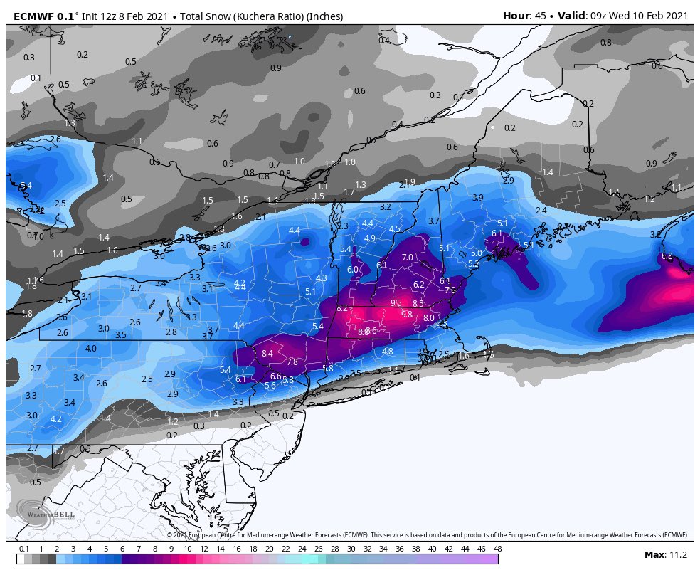
EURO comes on BOARD!! TOOT TOOT!!

_________________
Mugs
AKA:King: Snow Weenie
Self Proclaimed
WINTER 2014-15 : 55.12" +.02 for 6 coatings (avg. 35")
WINTER 2015-16 Total - 29.8" (Avg 35")
WINTER 2016-17 : 39.5" so far

amugs- Advanced Forecaster - Mod

- Posts : 15146
Reputation : 213
Join date : 2013-01-07
Age : 54
Location : Hillsdale,NJ
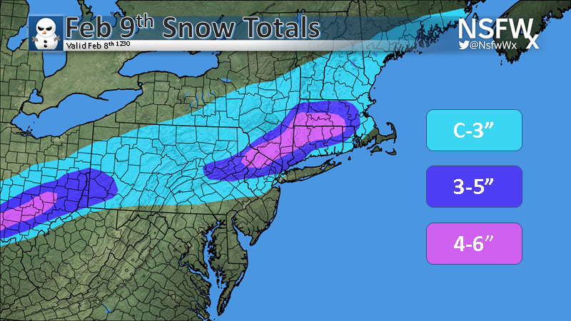
 Re: Back to Back Snow Events FEB 9th-11th
Frank_Wx wrote:jmanley32 wrote:so looks like the moidels favor N/W or metro area as the sweet spots, Frank had said 15:1 ratios so shouldnt the totals be sig higher so GFS shows 4 for me, wouldnt it be 6 then at 15:1? Did I do the match right its 1.5x the amount? I am very tired so if I did it wrong someone please remind me but anyways is Franks call factoring in the ratios?
Ratios are 10:1 for you and the city
They are higher Sullivan and Orange counties, as well as Sussex and Warren counties in NJ
3-6 north of I-80
2-4 between 80 and 78
Little to one inch south of 78
Did yuo guys confer?
_________________
Mugs
AKA:King: Snow Weenie
Self Proclaimed
WINTER 2014-15 : 55.12" +.02 for 6 coatings (avg. 35")
WINTER 2015-16 Total - 29.8" (Avg 35")
WINTER 2016-17 : 39.5" so far

amugs- Advanced Forecaster - Mod

- Posts : 15146
Reputation : 213
Join date : 2013-01-07
Age : 54
Location : Hillsdale,NJ
jmanley32 likes this post
 Re: Back to Back Snow Events FEB 9th-11th
12z EURO misses the wednesday/thursday storm
_________________
-Alex Iannone-

aiannone- Senior Enthusiast - Mod

- Posts : 4826
Reputation : 92
Join date : 2013-01-07
Location : Saint James, LI (Northwest Suffolk Co.)
heehaw453- Advanced Forecaster

- Posts : 3926
Reputation : 86
Join date : 2014-01-20
Location : Bedminster Township, PA Elevation 600' ASL
jmanley32 likes this post
 Re: Back to Back Snow Events FEB 9th-11th
So I had to look up these highways cuz I am not from NJ (wish you would put in NY highways lol, it appears I am north of I-80 but only by maybe 10-15 miles, is that enough to get into the 3-6? or should I say 2-6 being I am not that far north from I-80 but I am quite far north from I-78. And what is the start time of this?Frank_Wx wrote:jmanley32 wrote:so looks like the moidels favor N/W or metro area as the sweet spots, Frank had said 15:1 ratios so shouldnt the totals be sig higher so GFS shows 4 for me, wouldnt it be 6 then at 15:1? Did I do the match right its 1.5x the amount? I am very tired so if I did it wrong someone please remind me but anyways is Franks call factoring in the ratios?
Ratios are 10:1 for you and the city
They are higher Sullivan and Orange counties, as well as Sussex and Warren counties in NJ
3-6 north of I-80
2-4 between 80 and 78
Little to one inch south of 78
Last edited by jmanley32 on Mon Feb 08, 2021 2:33 pm; edited 1 time in total

jmanley32- Senior Enthusiast

- Posts : 20642
Reputation : 108
Join date : 2013-12-12
Age : 43
Location : Yonkers, NY
 Re: Back to Back Snow Events FEB 9th-11th
wow where do I sign? It is a tad early for them to be calling but then again it is only 2-3 days away, and for tomorrow I would think WSW or at least advisories would be up by now. Strange. Thats JUST for the 11th storm? Where are they seeing these kind of tottals for NYC area, did I miss a model? Nonetheless its crazy we are going boom boom boom day after day with snow, its amazing. The snow pack here is higher than i remember in at least 4-5 yrs and the cold did not ice it over its still fluffy unless you step in it then it compacts and its perfect snowball and snowman snow.

jmanley32- Senior Enthusiast

- Posts : 20642
Reputation : 108
Join date : 2013-12-12
Age : 43
Location : Yonkers, NY
 Re: Back to Back Snow Events FEB 9th-11th
18Z NAM is south.

nutleyblizzard- Senior Enthusiast

- Posts : 1963
Reputation : 41
Join date : 2014-01-30
Age : 58
Location : Nutley, new jersey
 Re: Back to Back Snow Events FEB 9th-11th
Is that good for me in Port Jefferson that Nam is South?
oldtimer- Senior Enthusiast

- Posts : 1103
Reputation : 14
Join date : 2013-01-16
Age : 78
Location : Port Jefferson Station Suffolk County
 Re: Back to Back Snow Events FEB 9th-11th
Wow i wasn't even pay attention to the nam, it had much of the area out of any snow at 12z and 18z as nutley said came way south, has rain into NYC area at one point, do you guys think that happens?

jmanley32- Senior Enthusiast

- Posts : 20642
Reputation : 108
Join date : 2013-12-12
Age : 43
Location : Yonkers, NY

CPcantmeasuresnow- Wx Statistician Guru

- Posts : 7281
Reputation : 230
Join date : 2013-01-07
Age : 103
Location : Eastern Orange County, NY
 Re: Back to Back Snow Events FEB 9th-11th
WWA up for my area now.NWS staying with 2 to 4 inches.Frank's 3 to 6 has a shot.

docstox12- Wx Statistician Guru

- Posts : 8610
Reputation : 222
Join date : 2013-01-07
Age : 74
Location : Monroe NY
 Re: Back to Back Snow Events FEB 9th-11th
Congrats northern guys looks like this is your storm, hopefully we all see something on 11th/12th. WWA doesn't include southern WC but thats okay, A day or two break is kinda needed here to clean up some more.

jmanley32- Senior Enthusiast

- Posts : 20642
Reputation : 108
Join date : 2013-12-12
Age : 43
Location : Yonkers, NY
 Re: Back to Back Snow Events FEB 9th-11th
WPC has .10-.25" qpf for the entire day tomorrow for my area, so maybe we could get a few inches out of it.
_________________
Janet
Snowfall winter of 2023-2024 17.5"
Snowfall winter of 2022-2023 6.0"
Snowfall winter of 2021-2022 17.6" 1" sleet 2/25/22
Snowfall winter of 2020-2021 51.1"
Snowfall winter of 2019-2020 8.5"
Snowfall winter of 2018-2019 25.1"
Snowfall winter of 2017-2018 51.9"
Snowfall winter of 2016-2017 45.6"
Snowfall winter of 2015-2016 29.5"
Snowfall winter of 2014-2015 50.55"
Snowfall winter of 2013-2014 66.5"
Dunnzoo- Senior Enthusiast - Mod

- Posts : 4934
Reputation : 68
Join date : 2013-01-11
Age : 62
Location : Westwood, NJ

aiannone- Senior Enthusiast - Mod

- Posts : 4826
Reputation : 92
Join date : 2013-01-07
Location : Saint James, LI (Northwest Suffolk Co.)

jmanley32- Senior Enthusiast

- Posts : 20642
Reputation : 108
Join date : 2013-12-12
Age : 43
Location : Yonkers, NY
 Re: Back to Back Snow Events FEB 9th-11th
NWS Upton WWA Criteria:
Winter Weather Advisory
Issued for a winter weather event in which there is more than one of the following: snow, sleet, and ice (freezing rain), and one of the advisory criteria is met but does not exceed warning criteria. In addition, a winter weather advisory will be issued for an all-snow event if the advisory criteria is met but does not exceed the warning criteria. The advisory criteria is 3 inches of snow and/or sleet expected in a 12 hour period, or a trace of ice accumulation. An advisory may still be warranted if lesser accumulations will significantly impact mass transit and/or utilities.
_________________
-Alex Iannone-

aiannone- Senior Enthusiast - Mod

- Posts : 4826
Reputation : 92
Join date : 2013-01-07
Location : Saint James, LI (Northwest Suffolk Co.)
 Re: Back to Back Snow Events FEB 9th-11th
By that map it appears to meet criteria.aiannone wrote:
NWS Upton WWA Criteria:
Winter Weather Advisory
Issued for a winter weather event in which there is more than one of the following: snow, sleet, and ice (freezing rain), and one of the advisory criteria is met but does not exceed warning criteria. In addition, a winter weather advisory will be issued for an all-snow event if the advisory criteria is met but does not exceed the warning criteria. The advisory criteria is 3 inches of snow and/or sleet expected in a 12 hour period, or a trace of ice accumulation. An advisory may still be warranted if lesser accumulations will significantly impact mass transit and/or utilities.

jmanley32- Senior Enthusiast

- Posts : 20642
Reputation : 108
Join date : 2013-12-12
Age : 43
Location : Yonkers, NY
Page 3 of 12 •  1, 2, 3, 4 ... 10, 11, 12
Page 3 of 12
Permissions in this forum:
You cannot reply to topics in this forum
 Home
Home

