Thursday's Mothrazilla, Part II: First Forecast
+44
bloc1357
Dunnzoo
hurrysundown23
larryrock72
phil155
dsvinos
docstox12
weatherwatchermom
SNOW MAN
kalleg
Snow88
Radz
Joe Snow
oldtimer
gigs68
mmanisca
Vinnydula
SkiSeadooJoe
algae888
jaydoy
dkodgis
Zhukov1945
skinsfan1177
2004blackwrx
lglickman1
Artingerb
Grselig
GreyBeard
moleson
nutleyblizzard
essexcountypete
billg315
sroc4
amugs
Fededle22
CPcantmeasuresnow
Irish
heehaw453
SENJsnowman
aiannone
DAYBLAZER
jmanley32
frank 638
Frank_Wx
48 posters
Page 5 of 18
Page 5 of 18 •  1, 2, 3, 4, 5, 6 ... 11 ... 18
 Re: Thursday's Mothrazilla, Part II: First Forecast
https://www.weather.gov/media/okx/021721_5pm.pdf
GreyBeard- Senior Enthusiast

- Posts : 732
Join date : 2014-02-12
amugs likes this post
 Re: Thursday's Mothrazilla, Part II: First Forecast
lglickman1 wrote:Has the heaviest axis of precipitation shifted south or is the euro an outlier with that?
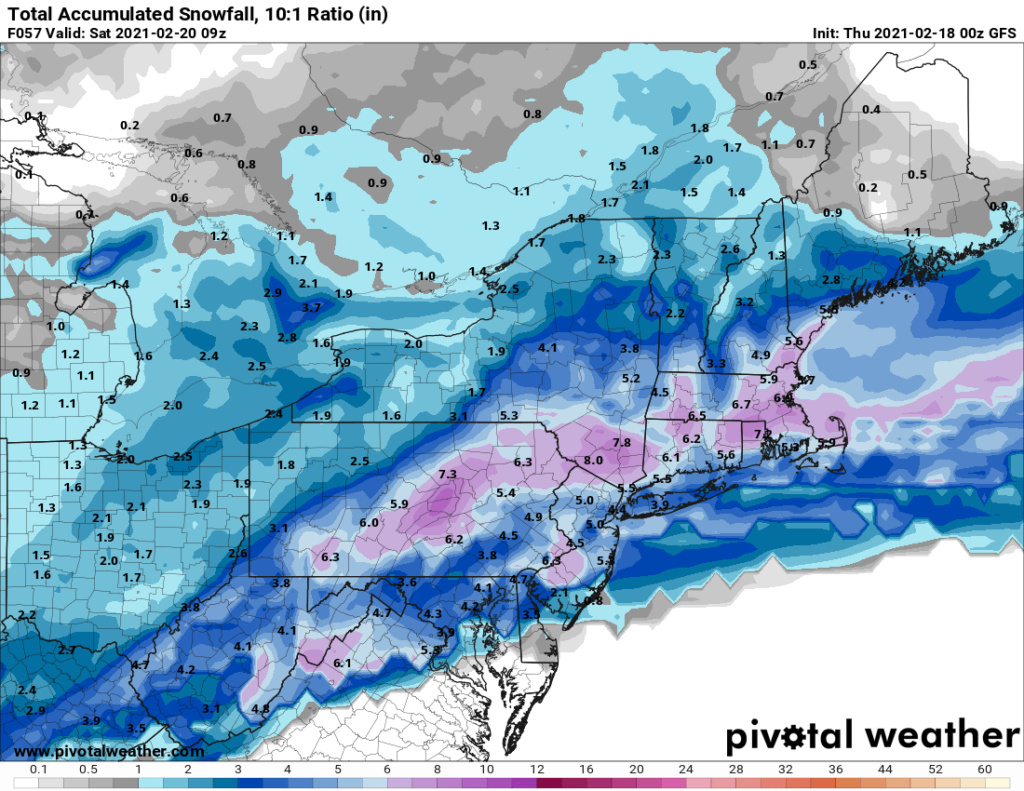
So the NAM and Euro both have that heaviest zone in pretty much the same location. The GFS is odd as, (I think Heehaw pointed this out) the GFS has the higher totals more north (but less expansive) but the GFS Para has the highest totals way south from DC through DE and far SNJ. I'm kind of tossing the GFS now because everything about it is acting weird. lol. And the Euro and NAM are closer to agreement.
billg315- Advanced Forecaster - Mod

- Posts : 4564
Join date : 2015-01-24
 Re: Thursday's Mothrazilla, Part II: First Forecast

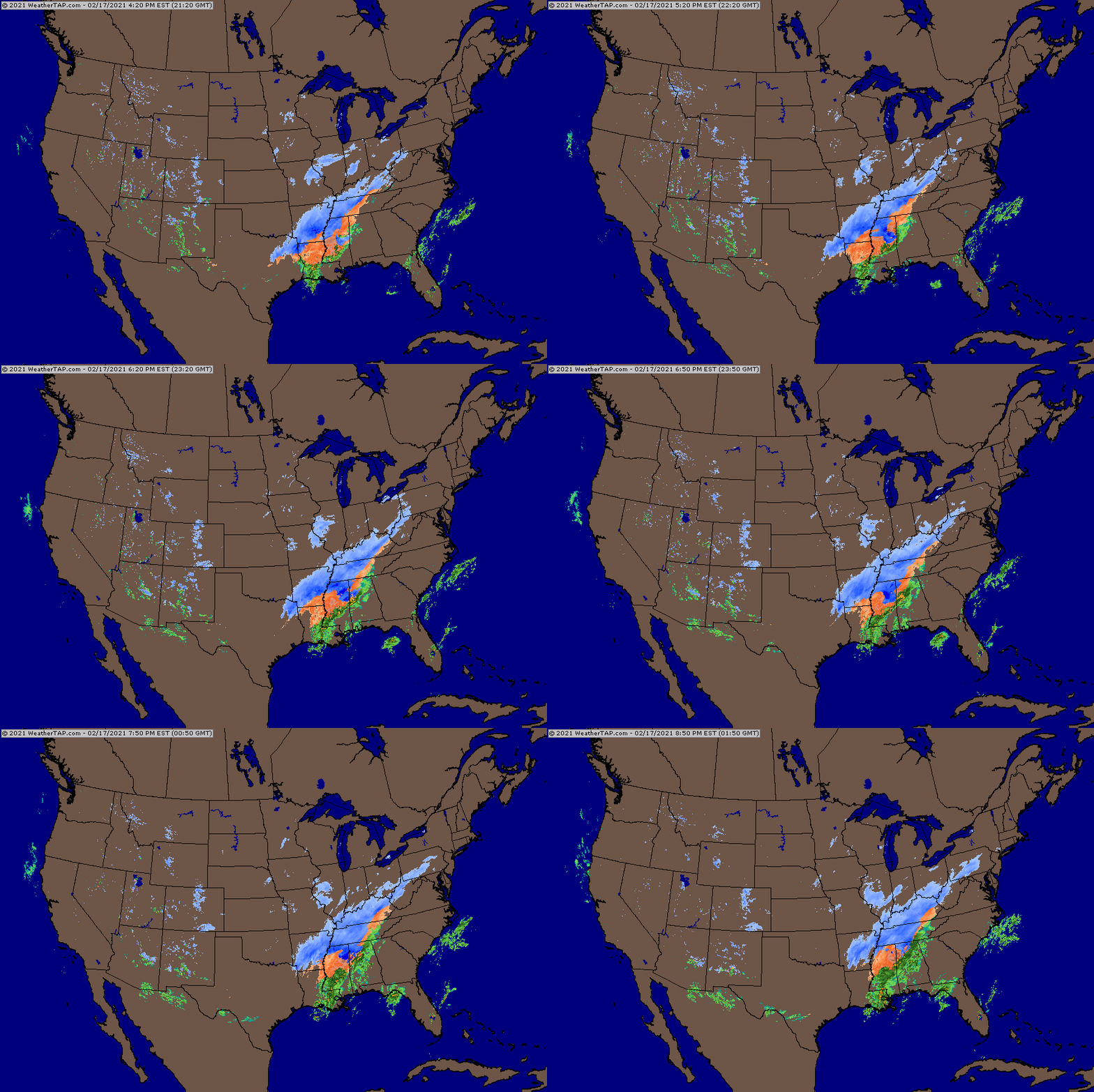
Look at all that warm convective moisture boyz - that what's coming up this way greater than modelled once again!
_________________
Mugs
AKA:King: Snow Weenie
Self Proclaimed
WINTER 2014-15 : 55.12" +.02 for 6 coatings (avg. 35")
WINTER 2015-16 Total - 29.8" (Avg 35")
WINTER 2016-17 : 39.5" so far

amugs- Advanced Forecaster - Mod

- Posts : 15157
Reputation : 213
Join date : 2013-01-07
Age : 54
Location : Hillsdale,NJ
 Re: Thursday's Mothrazilla, Part II: First Forecast
lets hope it leads to mothazilla for all
2004blackwrx- Pro Enthusiast

- Posts : 576
Reputation : 9
Join date : 2013-01-14
Location : Wappinger NY
 Re: Thursday's Mothrazilla, Part II: First Forecast
Bill: I moved all my work appts to tonight so I can enjoy tomorrow and now I gotta put Heckle and Jeckle to bed. I’ll be back in a few minutes. I’m still quite cautious though. I see 1-3” as just as likely as both 3-5” and 6-8” for down here.
SENJsnowman- Senior Enthusiast

- Posts : 1201
Reputation : 61
Join date : 2017-01-06
Age : 51
Location : Long Branch, NJ

skinsfan1177- Senior Enthusiast

- Posts : 4485
Reputation : 35
Join date : 2013-01-07
Age : 47
Location : Point Pleasant Boro
billg315 likes this post
 Re: Thursday's Mothrazilla, Part II: First Forecast
I think it's going to thump well tomorrow. Just not sure exactly how far north the initial WAA best frontogenesis gets. I think I-78 and points south have best shot at really impressive rates tomorrow morning and early afternoon. Could be NJ I-195 to NJ I-78 kind of zone which may avoid sleet and get impressive rates. I agree with Mugs this is going to be quite moist where the frontogenesis is best.
heehaw453- Advanced Forecaster

- Posts : 3941
Reputation : 86
Join date : 2014-01-20
Location : Bedminster Township, PA Elevation 600' ASL
 Re: Thursday's Mothrazilla, Part II: First Forecast
22* with a dewpoint of 10* here. Temperatures will be no issue in this part of the state -- at least at the surface. If I can keep the warm nose south or east of here I should get all snow, and whatever falls should stick in its entirety.

billg315- Advanced Forecaster - Mod

- Posts : 4564
Reputation : 185
Join date : 2015-01-24
Age : 50
Location : Flemington, NJ
Zhukov1945 likes this post

billg315- Advanced Forecaster - Mod

- Posts : 4564
Reputation : 185
Join date : 2015-01-24
Age : 50
Location : Flemington, NJ
 Re: Thursday's Mothrazilla, Part II: First Forecast
billg315 wrote:22* with a dewpoint of 10* here. Temperatures will be no issue in this part of the state -- at least at the surface. If I can keep the warm nose south or east of here I should get all snow, and whatever falls should stick in its entirety.
Hope you are right...learned to never underestimate the warm nose in this neck of the woods

Zhukov1945- Posts : 138
Reputation : 8
Join date : 2018-03-21
Location : Clinton Township NJ
billg315 likes this post
 Re: Thursday's Mothrazilla, Part II: First Forecast
Its 27 here. Just cold enough for all snow.

jmanley32- Senior Enthusiast

- Posts : 20648
Reputation : 108
Join date : 2013-12-12
Age : 43
Location : Yonkers, NY
 Re: Thursday's Mothrazilla, Part II: First Forecast
It is actually lightly snowing right now. 19 degrees. It looks cold enough here for tonight until snow’s end Fri. I thought this was supposed to start Thurs noonish?

dkodgis- Senior Enthusiast

- Posts : 2694
Reputation : 98
Join date : 2013-12-29
 Re: Thursday's Mothrazilla, Part II: First Forecast
Again as with SB storm and 2017-18 and 2014-15 storms. The convection in the South I'd a tell tale sign for how much latent heat, wv/moisture tnis will have and the frontogenesis that will be occurring once it gets up here. That just doesn't dissipate from experience. The moisture in front will saturate the column and then boom its like tstorms in the summer as we well know here. There will be positive surprises with this for some if not many


_________________
Mugs
AKA:King: Snow Weenie
Self Proclaimed
WINTER 2014-15 : 55.12" +.02 for 6 coatings (avg. 35")
WINTER 2015-16 Total - 29.8" (Avg 35")
WINTER 2016-17 : 39.5" so far

amugs- Advanced Forecaster - Mod

- Posts : 15157
Reputation : 213
Join date : 2013-01-07
Age : 54
Location : Hillsdale,NJ
 Re: Thursday's Mothrazilla, Part II: First Forecast
Hmm maybe I’m in the minority but the radar doesn’t look fantastic to me. It looked a lot better with the SB storm. 00z NAM kept almost all of SNJ in a mix and really tried to blow up the coastal element of the storm. Might get some nice banding setting up WNW of NYC tomorrow night into Friday
_________________
_______________________________________________________________________________________________________
CLICK HERE to view NJ Strong Snowstorm Classifications
 Re: Thursday's Mothrazilla, Part II: First Forecast
Frank the SB storm had much more convection than modeled and this one does too. Just using this an apology for compassion purposes
Snowing in Altoona and Armando S put up a great post on another board that portends to what I have been posting about the convection and 700 and 850 frontGenesis. Not wish casting but nowcasting. Time will tell but also GFS has a better Costal LP placement as well to bring some band into the NNJ LHV and NYC metro Friday afternoon and early evening
Snowing in Altoona and Armando S put up a great post on another board that portends to what I have been posting about the convection and 700 and 850 frontGenesis. Not wish casting but nowcasting. Time will tell but also GFS has a better Costal LP placement as well to bring some band into the NNJ LHV and NYC metro Friday afternoon and early evening
_________________
Mugs
AKA:King: Snow Weenie
Self Proclaimed
WINTER 2014-15 : 55.12" +.02 for 6 coatings (avg. 35")
WINTER 2015-16 Total - 29.8" (Avg 35")
WINTER 2016-17 : 39.5" so far

amugs- Advanced Forecaster - Mod

- Posts : 15157
Reputation : 213
Join date : 2013-01-07
Age : 54
Location : Hillsdale,NJ
 Re: Thursday's Mothrazilla, Part II: First Forecast
amugs wrote:Frank the SB storm had much more convection than modeled and this one does too. Just using this an apology for compassion purposes
Snowing in Altoona and Armando S put up a great post on another board that portends to what I have been posting about the convection and 700 and 850 frontGenesis. Not wish casting but nowcasting. Time will tell but also GFS has a better Costal LP placement as well to bring some band into the NNJ LHV and NYC metro Friday afternoon and early evening
I like weather forecasting apologies for compassion purposes too...can think of a lot of us on this board that would benefit from that

Zhukov1945- Posts : 138
Reputation : 8
Join date : 2018-03-21
Location : Clinton Township NJ
 Re: Thursday's Mothrazilla, Part II: First Forecast
Coastal on GFS sbows for 30 hours with this


_________________
Mugs
AKA:King: Snow Weenie
Self Proclaimed
WINTER 2014-15 : 55.12" +.02 for 6 coatings (avg. 35")
WINTER 2015-16 Total - 29.8" (Avg 35")
WINTER 2016-17 : 39.5" so far

amugs- Advanced Forecaster - Mod

- Posts : 15157
Reputation : 213
Join date : 2013-01-07
Age : 54
Location : Hillsdale,NJ
 Re: Thursday's Mothrazilla, Part II: First Forecast

_________________
Mugs
AKA:King: Snow Weenie
Self Proclaimed
WINTER 2014-15 : 55.12" +.02 for 6 coatings (avg. 35")
WINTER 2015-16 Total - 29.8" (Avg 35")
WINTER 2016-17 : 39.5" so far

amugs- Advanced Forecaster - Mod

- Posts : 15157
Reputation : 213
Join date : 2013-01-07
Age : 54
Location : Hillsdale,NJ
 Re: Thursday's Mothrazilla, Part II: First Forecast
Coastal looking like real deal fro Friday moderate snow from 4 am until about 4pm IF ITS RIGHT!
_________________
Mugs
AKA:King: Snow Weenie
Self Proclaimed
WINTER 2014-15 : 55.12" +.02 for 6 coatings (avg. 35")
WINTER 2015-16 Total - 29.8" (Avg 35")
WINTER 2016-17 : 39.5" so far

amugs- Advanced Forecaster - Mod

- Posts : 15157
Reputation : 213
Join date : 2013-01-07
Age : 54
Location : Hillsdale,NJ
 Re: Thursday's Mothrazilla, Part II: First Forecast
amugs wrote:Coastal looking like real deal fro Friday moderate snow from 4 am until about 4pm IF ITS RIGHT!
So is this a newer development?

Irish- Pro Enthusiast

- Posts : 788
Reputation : 19
Join date : 2019-01-16
Age : 46
Location : Old Bridge, NJ
 Re: Thursday's Mothrazilla, Part II: First Forecast
Just upped my predicted totals from 4-6 to possibly upwards of 11.

Irish- Pro Enthusiast

- Posts : 788
Reputation : 19
Join date : 2019-01-16
Age : 46
Location : Old Bridge, NJ

CPcantmeasuresnow- Wx Statistician Guru

- Posts : 7288
Reputation : 230
Join date : 2013-01-07
Age : 103
Location : Eastern Orange County, NY
 Re: Thursday's Mothrazilla, Part II: First Forecast
wait huh? This didnt look at all like this in any runs prior did it?amugs wrote:Coastal looking like real deal fro Friday moderate snow from 4 am until about 4pm IF ITS RIGHT!

jmanley32- Senior Enthusiast

- Posts : 20648
Reputation : 108
Join date : 2013-12-12
Age : 43
Location : Yonkers, NY
 Re: Thursday's Mothrazilla, Part II: First Forecast
yet highest is 8-9 inches and NYC south sees 4-5. Thats a super light snow high or low end for 30 hrs. I get that the main part comes at one point but its still not much and SNJ sees 1.2 qpf but only a few inches other than that one blob?!amugs wrote:Coastal looking like real deal fro Friday moderate snow from 4 am until about 4pm IF ITS RIGHT!
Last edited by jmanley32 on Wed Feb 17, 2021 11:25 pm; edited 1 time in total

jmanley32- Senior Enthusiast

- Posts : 20648
Reputation : 108
Join date : 2013-12-12
Age : 43
Location : Yonkers, NY
 Re: Thursday's Mothrazilla, Part II: First Forecast
GFS is wonky, doesnt show any kind of band like other models. And even though it shows precip for a long period it doesnt add up to a whole lot relatively speaking for many, and CP check it out if it's right you jackpot on this one buddy. I did not see that coming thought this was go be south of NYC win.


jmanley32- Senior Enthusiast

- Posts : 20648
Reputation : 108
Join date : 2013-12-12
Age : 43
Location : Yonkers, NY
CPcantmeasuresnow likes this post
 Re: Thursday's Mothrazilla, Part II: First Forecast
00z summary:
GFS- mostly 5-7", a few 4-5" spots and a few 6-10" jackpots (LHV).
CMC- mostly 4-6", So. NJ jackpot 6-9" thru all of coastal Ocean Co. Some 2" spots.
Icon- We all get 2-3"
Nam 12K- So NJ Spectacular- borderline GZ south of 95, 3-4" above it.


Nam 3K- So NJ Slight Edge- Same as above, but mostly 6" with some 8" south of 95, a layer of 4-6" right along 95 and LI and then 3-5 NEPA on thru NNJ and into LHV. Some spots with 2".
HRRR- 4-6" North of SENJsnowman and 1-3" from SENJ on down. 6-9" jackpot zones NNJ and LHV.
RGEM- generally 4-6", 6-8" jackpot zones in nw NJ and in eastern Suffolk County.
So, my analysis from that summary is that we are all in the game for anywhere from 2-8".
GFS- mostly 5-7", a few 4-5" spots and a few 6-10" jackpots (LHV).
CMC- mostly 4-6", So. NJ jackpot 6-9" thru all of coastal Ocean Co. Some 2" spots.
Icon- We all get 2-3"
Nam 12K- So NJ Spectacular- borderline GZ south of 95, 3-4" above it.
Nam 3K- So NJ Slight Edge- Same as above, but mostly 6" with some 8" south of 95, a layer of 4-6" right along 95 and LI and then 3-5 NEPA on thru NNJ and into LHV. Some spots with 2".
HRRR- 4-6" North of SENJsnowman and 1-3" from SENJ on down. 6-9" jackpot zones NNJ and LHV.
RGEM- generally 4-6", 6-8" jackpot zones in nw NJ and in eastern Suffolk County.
So, my analysis from that summary is that we are all in the game for anywhere from 2-8".
SENJsnowman- Senior Enthusiast

- Posts : 1201
Reputation : 61
Join date : 2017-01-06
Age : 51
Location : Long Branch, NJ
CPcantmeasuresnow and jmanley32 like this post
 Re: Thursday's Mothrazilla, Part II: First Forecast
I just compared all the models too, they are still all over the place jeeze. NAM is all south Jersey special with 2 inches here (in 24 hrs? cool, ill be able to show you guys each flake as they fall and i put them in my freezer. lol, to HRRR who is more uniform from central jersey to LHV. And anywhere in between, yeah 2-8 sounds right.

jmanley32- Senior Enthusiast

- Posts : 20648
Reputation : 108
Join date : 2013-12-12
Age : 43
Location : Yonkers, NY
Page 5 of 18 •  1, 2, 3, 4, 5, 6 ... 11 ... 18
Page 5 of 18
Permissions in this forum:
You cannot reply to topics in this forum
 Home
Home


