Long Range Discussion 22.0
Page 13 of 31 •  1 ... 8 ... 12, 13, 14 ... 22 ... 31
 Re: Long Range Discussion 22.0
rb924119- Meteorologist

- Posts : 7040
Join date : 2013-02-06
 Re: Long Range Discussion 22.0
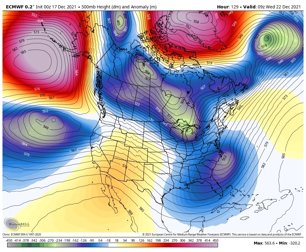
Mugs, the fact that it’s STILL correcting gives me the slightest hope. I would think that IF there are to be additional adjustments I’d look for the models to feel that block a bit more. Shift that Atlantic trough into a more classic 50/50 position, shift that low above the Great Lakes into better position more SW to act as more of an anchor or fulcrum to pivot the southern stream around - and the western ridge is already in a pretty good spot especially compared to what’s been out there lately. Just need it to hold and spike a bit more. I think it’s still not likely, but it’s the only thing to track, so…lol
MattyICE- Advanced Forecaster

- Posts : 249
Reputation : 6
Join date : 2017-11-10
Age : 39
Location : Clifton, NJ (Eastern Passaic County)
 Re: Long Range Discussion 22.0
Regardless of this outcome I think before end of December we're getting something light/moderate. Climatology and pattern.
heehaw453- Advanced Forecaster

- Posts : 3914
Reputation : 86
Join date : 2014-01-20
Location : Bedminster Township, PA Elevation 600' ASL
 Re: Long Range Discussion 22.0
_________________
"In weather and in life, there's no winning and losing; there's only winning and learning."
WINTER 2012/2013 TOTALS 43.65"WINTER 2017/2018 TOTALS 62.85" WINTER 2022/2023 TOTALS 4.9"
WINTER 2013/2014 TOTALS 64.85"WINTER 2018/2019 TOTALS 14.25" WINTER 2023/2024 TOTALS 13.1"
WINTER 2014/2015 TOTALS 71.20"WINTER 2019/2020 TOTALS 6.35"
WINTER 2015/2016 TOTALS 35.00"WINTER 2020/2021 TOTALS 37.75"
WINTER 2016/2017 TOTALS 42.25"WINTER 2021/2022 TOTALS 31.65"

sroc4- Admin

- Posts : 8446
Reputation : 302
Join date : 2013-01-07
Location : Wading River, LI
 Re: Long Range Discussion 22.0
I think that’s still on the table
_________________
_______________________________________________________________________________________________________
CLICK HERE to view NJ Strong Snowstorm Classifications
heehaw453 likes this post
rb924119- Meteorologist

- Posts : 7040
Reputation : 195
Join date : 2013-02-06
Age : 32
Location : Greentown, Pa
 Re: Long Range Discussion 22.0
rb924119- Meteorologist

- Posts : 7040
Reputation : 195
Join date : 2013-02-06
Age : 32
Location : Greentown, Pa
amugs and SENJsnowman like this post
 Re: Long Range Discussion 22.0
We’re at a point where OPs and ENS do not agree and run to run things are changing faster than a baby’s diaper. Especially an Italian, over fed one.
On a whole, the MJO wave we’ve all been interested in is trying really really hard to progress to phase 8. The Strat PV is still really strong at the top level, while the bottom level closer to the Trop is compromised from the active tropical forcing and -NAO development (wave 2 ridging), allowing warmer air to intrude and weaken the PV. This helps drive our AO negative in the weeks to come. But we really need this MJO wave to continue its eastward progression, and see if we can disrupt the PV on a much larger scale.
_________________
_______________________________________________________________________________________________________
CLICK HERE to view NJ Strong Snowstorm Classifications
rb924119 likes this post
 Re: Long Range Discussion 22.0

heehaw453- Advanced Forecaster

- Posts : 3914
Reputation : 86
Join date : 2014-01-20
Location : Bedminster Township, PA Elevation 600' ASL
weatherwatchermom likes this post
 Re: Long Range Discussion 22.0
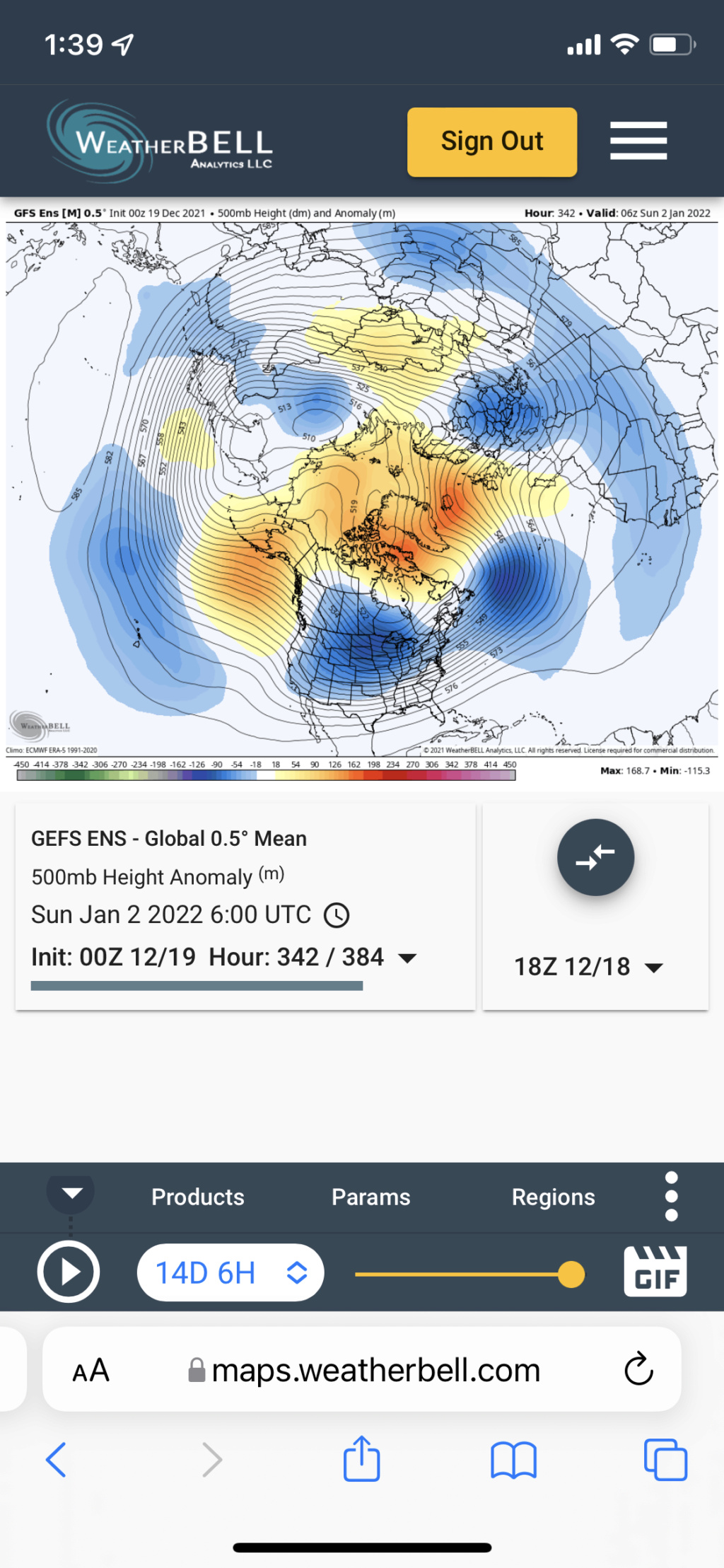
The models just wished us all a very merry New Year…….


Absolutely MASSIVE corrections here folks. Keep in mind these are ensemble means at Day 15. That trough signal over the U.S. for a lead time like that in multiple ensembles is no joke. You want crème de le crème Arctic air? YOU GOT IT!
“I think when we flip, we are going to flip HARD.” I haven’t checked, but that could very well be record challenging cold - you can’t get a much harder flip than that, and I think that’s just the beginning
Last edited by rb924119 on Sun Dec 19, 2021 1:48 am; edited 1 time in total
rb924119- Meteorologist

- Posts : 7040
Reputation : 195
Join date : 2013-02-06
Age : 32
Location : Greentown, Pa
amugs likes this post
 Re: Long Range Discussion 22.0
rb924119- Meteorologist

- Posts : 7040
Reputation : 195
Join date : 2013-02-06
Age : 32
Location : Greentown, Pa
amugs likes this post
 Re: Long Range Discussion 22.0
rb924119- Meteorologist

- Posts : 7040
Reputation : 195
Join date : 2013-02-06
Age : 32
Location : Greentown, Pa
rb924119- Meteorologist

- Posts : 7040
Reputation : 195
Join date : 2013-02-06
Age : 32
Location : Greentown, Pa
 Re: Long Range Discussion 22.0

Radz- Pro Enthusiast

- Posts : 1028
Reputation : 17
Join date : 2013-01-12
Location : Cortlandt Manor NY
rb924119 and SENJsnowman like this post
 Re: Long Range Discussion 22.0
https://www.cpc.ncep.noaa.gov/products/precip/CWlink/MJO/CLIVAR/ecmf.shtml

Snow88- Senior Enthusiast

- Posts : 2193
Reputation : 4
Join date : 2013-01-09
Age : 36
Location : Brooklyn, NY
rb924119 likes this post
 Re: Long Range Discussion 22.0
Hopefully the models are wrong and they show colder outcomes in future runs. I think the MJO is messing things up being stuck in

Snow88- Senior Enthusiast

- Posts : 2193
Reputation : 4
Join date : 2013-01-09
Age : 36
Location : Brooklyn, NY
rb924119 and phil155 like this post
 Re: Long Range Discussion 22.0
Okay this is EXACTLY what we need to see for the MJO and the waves that will affect it favorably. The one meteorology aspect I am noticing and have read about is how Weatern Pacific Tyohoons wreck havoc on the pattern Upstream and the MJO and models trying g to resolve the placement of the pressure patterns and subsequent jet structures. The latent heat release of these typhoons especially Rai that just hit the Philippines will aid in further disruption of the SPV due to all the warm moist water vapor that will travel poleward, physics of charged particles go to the magnetic pole. Which is actually in Siberia right now and is migrating towards the Indian Ocean. Another days discussion.
This a map of the outlined waves and what timeframe and what phase they will be in. IF this comes to fruition Rb nailed this like a piece of door molding to the door jamb!!

_________________
Mugs
AKA:King: Snow Weenie
Self Proclaimed
WINTER 2014-15 : 55.12" +.02 for 6 coatings (avg. 35")
WINTER 2015-16 Total - 29.8" (Avg 35")
WINTER 2016-17 : 39.5" so far

amugs- Advanced Forecaster - Mod

- Posts : 15130
Reputation : 213
Join date : 2013-01-07
Age : 54
Location : Hillsdale,NJ
rb924119 likes this post
 Re: Long Range Discussion 22.0

Snow88- Senior Enthusiast

- Posts : 2193
Reputation : 4
Join date : 2013-01-09
Age : 36
Location : Brooklyn, NY
rb924119 likes this post
 Re: Long Range Discussion 22.0
I think very cautious optimism is needed right now.
_________________
"In weather and in life, there's no winning and losing; there's only winning and learning."
WINTER 2012/2013 TOTALS 43.65"WINTER 2017/2018 TOTALS 62.85" WINTER 2022/2023 TOTALS 4.9"
WINTER 2013/2014 TOTALS 64.85"WINTER 2018/2019 TOTALS 14.25" WINTER 2023/2024 TOTALS 13.1"
WINTER 2014/2015 TOTALS 71.20"WINTER 2019/2020 TOTALS 6.35"
WINTER 2015/2016 TOTALS 35.00"WINTER 2020/2021 TOTALS 37.75"
WINTER 2016/2017 TOTALS 42.25"WINTER 2021/2022 TOTALS 31.65"

sroc4- Admin

- Posts : 8446
Reputation : 302
Join date : 2013-01-07
Location : Wading River, LI
rb924119, heehaw453 and phil155 like this post
 Re: Long Range Discussion 22.0
sroc4 wrote:I’ve been quiet. I am just not sure. I am just not that excited about any of it right now. Until the PNA region changes I just don’t know. The PNA is currently sitting between -3 & -4 standard deviations and forecast is to get down to -5 over the next 3-5 days, and remain somewhere between -4 & -5 for 7-10days beyond that before slowly coming back up as we head into the first week of Jan. But even then it’s still -1 to -2. With a PNA that negative it give the atmosphere a back door to slip out of. It allows the cold to pool in the west despite the -NAO/-AO/-EPO, Make no mistake it will get colder than it has been for sure, and there may be some snow chances, but the sustained cold and more importantly and likely is the storm track is likely to remain meh at best. At least for awhile.
I think very cautious optimism is needed right now.
No question about it that it's nickel and dime stuff at best until PAC becomes less hostile. If AO starts reversing in January to positive territory, then my thought is we'll be potentially anomalously low snowfall this year. Even with a decent -AO I still think we run the risk of cold/dry conditions with below normal snowfall if PAC doesn't want to play ball. Any perturbation of the PV is high risk/reward kind of thing. Very hard to know if those effects until the split or displacement occurs. I share that cautious optimism.
heehaw453- Advanced Forecaster

- Posts : 3914
Reputation : 86
Join date : 2014-01-20
Location : Bedminster Township, PA Elevation 600' ASL
sroc4, rb924119 and phil155 like this post
 Re: Long Range Discussion 22.0

_________________
Mugs
AKA:King: Snow Weenie
Self Proclaimed
WINTER 2014-15 : 55.12" +.02 for 6 coatings (avg. 35")
WINTER 2015-16 Total - 29.8" (Avg 35")
WINTER 2016-17 : 39.5" so far

amugs- Advanced Forecaster - Mod

- Posts : 15130
Reputation : 213
Join date : 2013-01-07
Age : 54
Location : Hillsdale,NJ
rb924119 likes this post
 Re: Long Range Discussion 22.0
amugs wrote:if true then whoa!!
If true the pattern will do a complete 180
Let’s hope!!
_________________
_______________________________________________________________________________________________________
CLICK HERE to view NJ Strong Snowstorm Classifications
amugs, SENJsnowman and phil155 like this post
 Re: Long Range Discussion 22.0
Frank_Wx wrote:amugs wrote:if true then whoa!!
If true the pattern will do a complete 180
Let’s hope!!
Frank or Mugs please explain. I have barely a clue what this represents. I know it’s something I’d like just from Mugsys reaction and Frank’s comment but would love to know the reason. Also what time period are we talking about this possible 180?
Thanks I advance.

CPcantmeasuresnow- Wx Statistician Guru

- Posts : 7274
Reputation : 230
Join date : 2013-01-07
Age : 103
Location : Eastern Orange County, NY
 Re: Long Range Discussion 22.0
CPcantmeasuresnow wrote:Frank_Wx wrote:amugs wrote:if true then whoa!!
If true the pattern will do a complete 180
Let’s hope!!
Frank or Mugs please explain. I have barely a clue what this represents. I know it’s something I’d like just from Mugsys reaction and Frank’s comment but would love to know the reason. Also what time period are we talking about this possible 180?
Thanks I advance.
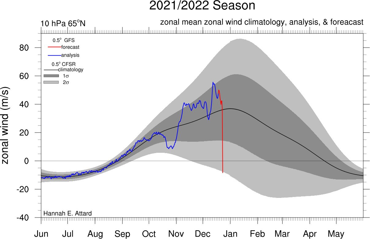
I’m not them, lol, but this is my stab - VERBATIM this indicates a reversal of the zonal winds way up at the top of the stratosphere. This would end our period of a very strong (positive) polar vortex and suggest at least a significant weakening - maybe even a sudden stratospheric warming event or something in between (regardless it would portend a negative Arctic Oscillation and help displace colder air further south). If the strat and trop are coupled there is still frequently a lag of usually 2 weeks before results propagate down to our sensible weather. Could be right inline with a lot of what Ray has been highlighting as his process and timeline, if correct.
MattyICE- Advanced Forecaster

- Posts : 249
Reputation : 6
Join date : 2017-11-10
Age : 39
Location : Clifton, NJ (Eastern Passaic County)
Frank_Wx, sroc4, amugs, CPcantmeasuresnow, rb924119 and SENJsnowman like this post
 Re: Long Range Discussion 22.0
CPcantmeasuresnow wrote:Frank_Wx wrote:amugs wrote:if true then whoa!!
If true the pattern will do a complete 180
Let’s hope!!
Frank or Mugs please explain. I have barely a clue what this represents. I know it’s something I’d like just from Mugsys reaction and Frank’s comment but would love to know the reason. Also what time period are we talking about this possible 180?
Thanks I advance.
Not a whole lot to add to Matty Ice's comments.
Click the link. This is the current winds at the 10 mb level. Save this link to favorites and come back to it in a few weeks to see how it has evolved.
For those who have never seen this site its pretty cool. Bottom left click on "EARTH" to play with the different levels of the atmosphere from 10 mb(hpa) of the stratosphere down to the surface. Also left click and hold anywhere over the image and move the mouse to manipulate the position of the earth view and use your mouses wheel to zoom in and out.
https://earth.nullschool.net/#current/wind/isobaric/10hPa/orthographic=-80.99,72.04,414
_________________
"In weather and in life, there's no winning and losing; there's only winning and learning."
WINTER 2012/2013 TOTALS 43.65"WINTER 2017/2018 TOTALS 62.85" WINTER 2022/2023 TOTALS 4.9"
WINTER 2013/2014 TOTALS 64.85"WINTER 2018/2019 TOTALS 14.25" WINTER 2023/2024 TOTALS 13.1"
WINTER 2014/2015 TOTALS 71.20"WINTER 2019/2020 TOTALS 6.35"
WINTER 2015/2016 TOTALS 35.00"WINTER 2020/2021 TOTALS 37.75"
WINTER 2016/2017 TOTALS 42.25"WINTER 2021/2022 TOTALS 31.65"

sroc4- Admin

- Posts : 8446
Reputation : 302
Join date : 2013-01-07
Location : Wading River, LI
CPcantmeasuresnow and rb924119 like this post
 Re: Long Range Discussion 22.0
MattICE ICE baby this would change the complexity of the pattern and cause higher pressures over the Arctic dislodged arctic air southward. This shows a perturbed polar vortex. The affects would be very positive overall.
Good explanation Matty.
Now for the MJO wave. See the greenish colors those are our waves, lower pressures. The map underneath shows the phases of the MJO. Remember phase 8-1-2 are the heart of winter phases we do very well with wintry weather.
We are in phase seven going into 8.
Then you see at Jan 6th time through the end of the run the wave develops in the Indian Ocean and is a strong 1 then 2 as we end Jan. This aligns with Rb thoughts on 2nd week to 3rd week things take off. Patience for sure but looking very good.

_________________
Mugs
AKA:King: Snow Weenie
Self Proclaimed
WINTER 2014-15 : 55.12" +.02 for 6 coatings (avg. 35")
WINTER 2015-16 Total - 29.8" (Avg 35")
WINTER 2016-17 : 39.5" so far

amugs- Advanced Forecaster - Mod

- Posts : 15130
Reputation : 213
Join date : 2013-01-07
Age : 54
Location : Hillsdale,NJ
CPcantmeasuresnow, rb924119 and MattyICE like this post
Page 13 of 31 •  1 ... 8 ... 12, 13, 14 ... 22 ... 31

 Home
Home


