Long Range Thread 25.0
+42
toople
Coachgriff
Carvin
Scullybutcher
Wheezer
lglickman1
dolphins222
Grselig
Zhukov1945
aiannone
CPcantmeasuresnow
jimv45
JT33
TheAresian
Radz
brownie
SENJsnowman
billg315
hyde345
SoulSingMG
Math23x7
phil155
snowbunny
mmanisca
Abba701
MattyICE
GreyBeard
nutleyblizzard
heehaw453
weatherwatchermom
HectorO
jmanley32
Irish
dkodgis
Dunnzoo
sroc4
algae888
Frank_Wx
kalleg
frank 638
docstox12
amugs
46 posters
Page 13 of 40
Page 13 of 40 •  1 ... 8 ... 12, 13, 14 ... 26 ... 40
 Re: Long Range Thread 25.0
jmanley32 wrote:Well I just saw 12z operational and wow, dumptoms snow ferocias winds what more could you ask for? and on the 24th as I expected, that is a monster verbatim if it was further west by not even that much would be a roid potentially. Still waiting for that elusive frankzilla lol, I fully expect a poor photoshop of franks head on a godzilla if that ever happens lol. 3-4 ft between the two storms for beantown, damn them lol, lets get this west.


sroc4- Admin

- Posts : 8443
Join date : 2013-01-07
 Re: Long Range Thread 25.0
glad you liked that lolsroc4 wrote:jmanley32 wrote:Well I just saw 12z operational and wow, dumptoms snow ferocias winds what more could you ask for? and on the 24th as I expected, that is a monster verbatim if it was further west by not even that much would be a roid potentially. Still waiting for that elusive frankzilla lol, I fully expect a poor photoshop of franks head on a godzilla if that ever happens lol. 3-4 ft between the two storms for beantown, damn them lol, lets get this west.


jmanley32- Senior Enthusiast

- Posts : 20635
Join date : 2013-12-12
 Re: Long Range Thread 25.0
The 18z GFS shows snow and rain for the 24th.
Abba701- Posts : 328
Reputation : 0
Join date : 2013-01-14
 Re: Long Range Thread 25.0
Abba701 wrote:The 18z GFS shows snow and rain for the 24th.
I'm still seeing the storm for the 22nd-23rd and early forecast for 4-12 in snowfall range.

Irish- Pro Enthusiast

- Posts : 788
Reputation : 19
Join date : 2019-01-16
Age : 46
Location : Old Bridge, NJ
 Re: Long Range Thread 25.0
TWC is going to spit out more non-sense snow total amounts than a broken gumball machine. You and I both know not to pay attention to those but as you said earlier it does show they see a potentially significant storm. And if it is saying it down there where you often have a harder time getting snow then its gonna potentially be good for all. That is if it happens at all. Kinda surprised even TWC is putting out snow amounts a week ahead of time.Irish wrote:Abba701 wrote:The 18z GFS shows snow and rain for the 24th.
I'm still seeing the storm for the 22nd-23rd and early forecast for 4-12 in snowfall range.

jmanley32- Senior Enthusiast

- Posts : 20635
Reputation : 108
Join date : 2013-12-12
Age : 43
Location : Yonkers, NY
 Re: Long Range Thread 25.0
18z was a massive hit double digits for many verbatim even with the rain, it actually comes in two waves of LP and the first combines over the area if that can happen earlier I think we would see a roid outcome/ That run was mainly snow though. Those tightly packed isobars would make for one heck of a you know what, not gonna jinx it don't say it anyone!Abba701 wrote:The 18z GFS shows snow and rain for the 24th.

jmanley32- Senior Enthusiast

- Posts : 20635
Reputation : 108
Join date : 2013-12-12
Age : 43
Location : Yonkers, NY
 Re: Long Range Thread 25.0
jmanley32 wrote:TWC is going to spit out more non-sense snow total amounts than a broken gumball machine. You and I both know not to pay attention to those but as you said earlier it does show they see a potentially significant storm. And if it is saying it down there where you often have a harder time getting snow then its gonna potentially be good for all. That is if it happens at all. Kinda surprised even TWC is putting out snow amounts a week ahead of time.Irish wrote:Abba701 wrote:The 18z GFS shows snow and rain for the 24th.
I'm still seeing the storm for the 22nd-23rd and early forecast for 4-12 in snowfall range.
You nailed it there, that's exactly my point. The snow total predictions at this point are fantasy land but the fact that they're posting them up there, means this event could be pretty damn solid.

Irish- Pro Enthusiast

- Posts : 788
Reputation : 19
Join date : 2019-01-16
Age : 46
Location : Old Bridge, NJ
 Re: Long Range Thread 25.0
Greetings! I just wanted to say I missed you guys - the banter, the charts, the analysis - and most excitedly - THE SNOW!!!
JT33- Posts : 42
Reputation : 0
Join date : 2022-01-25
Location : Piscataway
Frank_Wx, sroc4, jmanley32 and Irish like this post
 Re: Long Range Thread 25.0
We lost the storm in most recent runs it looks like? Things trended warmer and so now mixing. We'll see where she goes...

Irish- Pro Enthusiast

- Posts : 788
Reputation : 19
Join date : 2019-01-16
Age : 46
Location : Old Bridge, NJ
 Re: Long Range Thread 25.0
It def needs to be recognized that a warmer soln is still plausible. I pains me to do this but Bernie Rayno is in the camp of a western inland track. You really only need to listen to the first 3 mins to get his thoughts. After that he discusses all the details in the models. Now he like all of us is human and is not perfect and def does not get it right every time. Again we have to acknowledge that this far out everything is plausible.
Last edited by sroc4 on Fri Dec 16, 2022 7:11 am; edited 1 time in total
_________________
"In weather and in life, there's no winning and losing; there's only winning and learning."
WINTER 2012/2013 TOTALS 43.65"WINTER 2017/2018 TOTALS 62.85" WINTER 2022/2023 TOTALS 4.9"
WINTER 2013/2014 TOTALS 64.85"WINTER 2018/2019 TOTALS 14.25" WINTER 2023/2024 TOTALS 13.1"
WINTER 2014/2015 TOTALS 71.20"WINTER 2019/2020 TOTALS 6.35"
WINTER 2015/2016 TOTALS 35.00"WINTER 2020/2021 TOTALS 37.75"
WINTER 2016/2017 TOTALS 42.25"WINTER 2021/2022 TOTALS 31.65"

sroc4- Admin

- Posts : 8443
Reputation : 302
Join date : 2013-01-07
Location : Wading River, LI
 Re: Long Range Thread 25.0
Irish wrote:We lost the storm in most recent runs it looks like? Things trended warmer and so now mixing. We'll see where she goes...
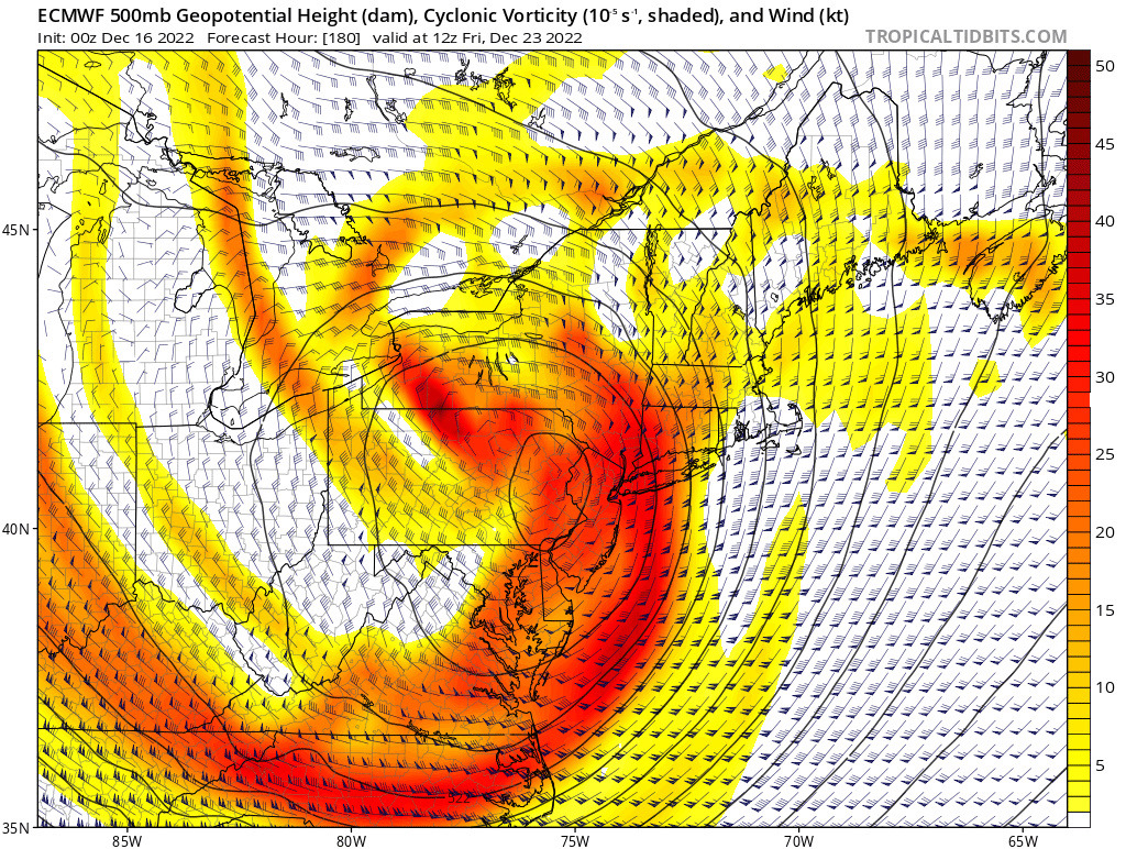
Certainly did not lose the storm. In fact, the signal for a storm is growing stronger by the day. Your other point about it trending warmer is true, but those details are insignificant right now. What the EURO showed last night was a nuke. Godzilla through and through. But obviously it developed too rapidly and brought the upper level low over NJ. Need this baby to our south and east.
_________________
_______________________________________________________________________________________________________
CLICK HERE to view NJ Strong Snowstorm Classifications
 Re: Long Range Thread 25.0
Looks like there’s been a slight change to the long range pattern. Earlier it seemed models were keen on maintaining a very strong -EPO through the month, but now that ridge is replaced with a trough over Alaska. This turns the EPO positive. Luckily, the PNA is showing up positive and the NAO is modeled to be negative. So we’re still in a good place to see our first widespread snow event sometime after the 23rd. What’s kinda cool is the extremely negative EPO that was shown before seemed to suppress some waves which lead to brutally cold but dry conditions. My thinking is this could be a positive change for us. We shall see
_________________
_______________________________________________________________________________________________________
CLICK HERE to view NJ Strong Snowstorm Classifications
 Re: Long Range Thread 25.0
Frank_Wx wrote:Irish wrote:We lost the storm in most recent runs it looks like? Things trended warmer and so now mixing. We'll see where she goes...
Certainly did not lose the storm. In fact, the signal for a storm is growing stronger by the day. Your other point about it trending warmer is true, but those details are insignificant right now. What the EURO showed last night was a nuke. Godzilla through and through. But obviously it developed too rapidly and brought the upper level low over NJ. Need this baby to our south and east.
Poor wording on my part, didn't me lose it in the sense that's it's off the table, more in terms of how it was looking as an all snow solution, as in tracking further west and bringing in the warm air. But there are a bunch of changes to come, so we'll see.

Irish- Pro Enthusiast

- Posts : 788
Reputation : 19
Join date : 2019-01-16
Age : 46
Location : Old Bridge, NJ
 Re: Long Range Thread 25.0
Irish wrote:Frank_Wx wrote:Irish wrote:We lost the storm in most recent runs it looks like? Things trended warmer and so now mixing. We'll see where she goes...
Certainly did not lose the storm. In fact, the signal for a storm is growing stronger by the day. Your other point about it trending warmer is true, but those details are insignificant right now. What the EURO showed last night was a nuke. Godzilla through and through. But obviously it developed too rapidly and brought the upper level low over NJ. Need this baby to our south and east.
Poor wording on my part, didn't me lose it in the sense that's it's off the table, more in terms of how it was looking as an all snow solution, as in tracking further west and bringing in the warm air. But there are a bunch of changes to come, so we'll see.
Irish, this is actually what I would to see right now bc I’ve yet to see where a major snowstorm for us stayed on the models just as modeled before day 5. Every single big storm that’s hit my back yard since I’ve moved up here 10 yrs ago has had a huge windshield wiper effect at this range. In fact, don’t even put the bullseye over my house until day 3 at the earliest please. But like you say, the signal for something big is there, and we’re just now in the the 5-7 day zone, so the changes that happen in the next 2-3 days should tell the story…
SENJsnowman- Senior Enthusiast

- Posts : 1196
Reputation : 61
Join date : 2017-01-06
Age : 51
Location : Long Branch, NJ
 Re: Long Range Thread 25.0
I feel much better about this event next week than I did about the previous one. Several reasons 1/better ridge will yield a more potent and dynamic storm, 2/better antecedent air mass, 3/more abundant cold that can get pulled into the storm. We need to watch how far the ULL digs based on the west ridge axis. The storm has a potential to negatively tilt too. Where the 500mb trough sets up will be key and how quickly it goes neutral to negative will determine the mid-level energy either running inland or off shore. If I was on the 95 right now I set my expectations for getting on the snow board with at least a few inches. Because even if it flips I think there's enough antecedent cold to get some snow. Will be fun to track this one.
heehaw453- Advanced Forecaster

- Posts : 3908
Reputation : 86
Join date : 2014-01-20
Location : Bedminster Township, PA Elevation 600' ASL
MattyICE and Irish like this post
 Re: Long Range Thread 25.0
Synoptic setup on this one IMO. It's critical for the ULL to go underneath the area for us to get big snow amounts. Just showing this for informational purposes the outcome is far from known. I feel confident we're going to have a strong Davis Straight block and a PNA that is rising. Very good. What I'm not sure about is how much does the lead energy eject out and creates a steering mechanism for the ULL and its trough? The picture below shows a good setup with things moving along to do a rising PNA.
If the lead energy gets held back then Godzilla or even sig snow is off the table for this area as the ULL will tend to pull northward and amplify too quickly which will create a coastal hugger/inland runner. The better slope the PNA provides makes is much less likely that happens IMO. Things need to move along under the block and the 50/50 can provide the additional height dampening and resistance to the storm. There's a path to victory, just don't know yet.
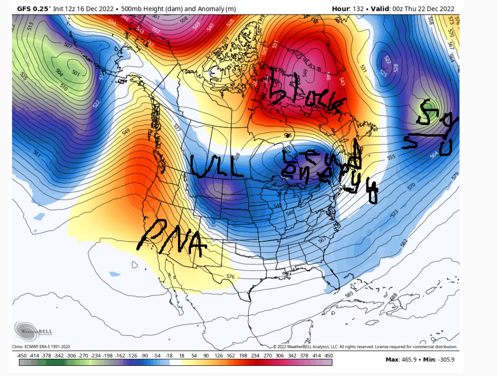
If the lead energy gets held back then Godzilla or even sig snow is off the table for this area as the ULL will tend to pull northward and amplify too quickly which will create a coastal hugger/inland runner. The better slope the PNA provides makes is much less likely that happens IMO. Things need to move along under the block and the 50/50 can provide the additional height dampening and resistance to the storm. There's a path to victory, just don't know yet.

heehaw453- Advanced Forecaster

- Posts : 3908
Reputation : 86
Join date : 2014-01-20
Location : Bedminster Township, PA Elevation 600' ASL
 Re: Long Range Thread 25.0
heehaw453 wrote:Synoptic setup on this one IMO. It's critical for the ULL to go underneath the area for us to get big snow amounts. Just showing this for informational purposes the outcome is far from known. I feel confident we're going to have a strong Davis Straight block and a PNA that is rising. Very good. What I'm not sure about is how much does the lead energy eject out and creates a steering mechanism for the ULL and its trough? The picture below shows a good setup with things moving along to do a rising PNA.
If the lead energy gets held back then Godzilla or even sig snow is off the table for this area as the ULL will tend to pull northward and amplify too quickly which will create a coastal hugger/inland runner. The better slope the PNA provides makes is much less likely that happens IMO. Things need to move along under the block and the 50/50 can provide the additional height dampening and resistance to the storm. There's a path to victory, just don't know yet.
CMCShowed us what not to happen..ie: worst case scenario for snow lovers. Below is the key....the west. Look at the orange colors along the west coast. Without them our main energy does not dig as it progresses east. It spins up into a strong ULL too soon and charges north very similar to todays set up. GFS has a much more potent PNA ridge which allows our main energy to dig and become closed and head NE later along the coast. Notice in these two identical time stamps GFS hasent closed off yet but CMC did. While it isnt the only factor it is one of the MAIN factors on what happens here.
_________________
"In weather and in life, there's no winning and losing; there's only winning and learning."
WINTER 2012/2013 TOTALS 43.65"WINTER 2017/2018 TOTALS 62.85" WINTER 2022/2023 TOTALS 4.9"
WINTER 2013/2014 TOTALS 64.85"WINTER 2018/2019 TOTALS 14.25" WINTER 2023/2024 TOTALS 13.1"
WINTER 2014/2015 TOTALS 71.20"WINTER 2019/2020 TOTALS 6.35"
WINTER 2015/2016 TOTALS 35.00"WINTER 2020/2021 TOTALS 37.75"
WINTER 2016/2017 TOTALS 42.25"WINTER 2021/2022 TOTALS 31.65"

sroc4- Admin

- Posts : 8443
Reputation : 302
Join date : 2013-01-07
Location : Wading River, LI
 Re: Long Range Thread 25.0
^^^ sroc I have a feeling the PNA is going to better than what the CMC is showing. The lead energy needs to get out of the way quickly and the PNA is the key for that to happen IMO.
heehaw453- Advanced Forecaster

- Posts : 3908
Reputation : 86
Join date : 2014-01-20
Location : Bedminster Township, PA Elevation 600' ASL
sroc4 likes this post
 Re: Long Range Thread 25.0
This time next week I see the temps diving but before they looked real low. Here lately the temps are cold, appropriate for this time of year but not as low as a week ago. I guess the forecast caught up with the models. It looks cold but not "oh my goodness cold" is coming next week

dkodgis- Senior Enthusiast

- Posts : 2667
Reputation : 98
Join date : 2013-12-29
 Re: Long Range Thread 25.0
sroc4 wrote:heehaw453 wrote:Synoptic setup on this one IMO. It's critical for the ULL to go underneath the area for us to get big snow amounts. Just showing this for informational purposes the outcome is far from known. I feel confident we're going to have a strong Davis Straight block and a PNA that is rising. Very good. What I'm not sure about is how much does the lead energy eject out and creates a steering mechanism for the ULL and its trough? The picture below shows a good setup with things moving along to do a rising PNA.
If the lead energy gets held back then Godzilla or even sig snow is off the table for this area as the ULL will tend to pull northward and amplify too quickly which will create a coastal hugger/inland runner. The better slope the PNA provides makes is much less likely that happens IMO. Things need to move along under the block and the 50/50 can provide the additional height dampening and resistance to the storm. There's a path to victory, just don't know yet.
CMCShowed us what not to happen..ie: worst case scenario for snow lovers. Below is the key....the west. Look at the orange colors along the west coast. Without them our main energy does not dig as it progresses east. It spins up into a strong ULL too soon and charges north very similar to todays set up. GFS has a much more potent PNA ridge which allows our main energy to dig and become closed and head NE later along the coast. Notice in these two identical time stamps GFS hasent closed off yet but CMC did. While it isnt the only factor it is one of the MAIN factors on what happens here.
heehaw453 wrote:^^^ sroc I have a feeling the PNA is going to better than what the CMC is showing. The lead energy needs to get out of the way quickly and the PNA is the key for that to happen IMO.
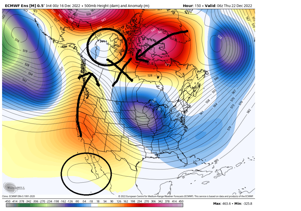
I sure hope so. If you look at the two frames I posted pay attention to the position of the sm ULL just off he SW coast. GFS has it much further N just SW of S tip of Cali; whereas, CMC has it SW off the tip of the Baja peninsula. The position on the GFS aids in maintain that PNA ridge to its N. If you look at any of the strong blocking ridges in the images you will notice a corresponding trough beneath it helping to strengthen it. This area, off the SW coast and the west coast of the CONUS is no different IMO
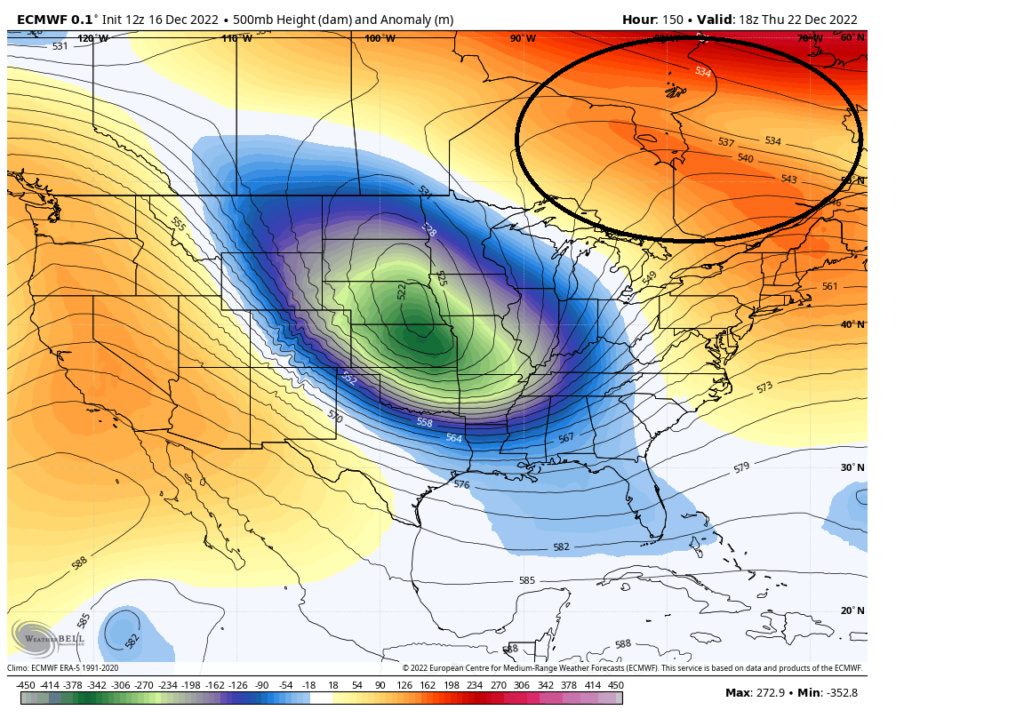
Ive notice that the EPS has the southern position for this feauture as well whereas the GEFS is a tad further N. The other area that I just dont like is the area circled in NW Canada in the image below. Every model, ensemble or Op, has this feature to some degree or another. It's preventing a true "ridge bridge" from forming between the PNA region and the NAO or AO region, creating a weak spot for an over amped system to push north into. I dont like it. If we can delay our system from closing off long enough, ie: better PNA, then we get under the NAO ridge and good things happen from there, but if we dont, and we amplify too early then we charge N into that weakness, with a warm surge, before finally feeling the blocking in the NAO region and reforming a low in the NE but too late.
_________________
"In weather and in life, there's no winning and losing; there's only winning and learning."
WINTER 2012/2013 TOTALS 43.65"WINTER 2017/2018 TOTALS 62.85" WINTER 2022/2023 TOTALS 4.9"
WINTER 2013/2014 TOTALS 64.85"WINTER 2018/2019 TOTALS 14.25" WINTER 2023/2024 TOTALS 13.1"
WINTER 2014/2015 TOTALS 71.20"WINTER 2019/2020 TOTALS 6.35"
WINTER 2015/2016 TOTALS 35.00"WINTER 2020/2021 TOTALS 37.75"
WINTER 2016/2017 TOTALS 42.25"WINTER 2021/2022 TOTALS 31.65"

sroc4- Admin

- Posts : 8443
Reputation : 302
Join date : 2013-01-07
Location : Wading River, LI
 Re: Long Range Thread 25.0
And euro is rolling. Kep in mind here folks we are still pretty far out so details on these individual runs are not the final solns. A trend in these details between now and late Sunday will only begin to clarify things
_________________
"In weather and in life, there's no winning and losing; there's only winning and learning."
WINTER 2012/2013 TOTALS 43.65"WINTER 2017/2018 TOTALS 62.85" WINTER 2022/2023 TOTALS 4.9"
WINTER 2013/2014 TOTALS 64.85"WINTER 2018/2019 TOTALS 14.25" WINTER 2023/2024 TOTALS 13.1"
WINTER 2014/2015 TOTALS 71.20"WINTER 2019/2020 TOTALS 6.35"
WINTER 2015/2016 TOTALS 35.00"WINTER 2020/2021 TOTALS 37.75"
WINTER 2016/2017 TOTALS 42.25"WINTER 2021/2022 TOTALS 31.65"

sroc4- Admin

- Posts : 8443
Reputation : 302
Join date : 2013-01-07
Location : Wading River, LI
 Re: Long Range Thread 25.0
Weather Bell site keeps crashing through hr129 I am not thrilled
_________________
"In weather and in life, there's no winning and losing; there's only winning and learning."
WINTER 2012/2013 TOTALS 43.65"WINTER 2017/2018 TOTALS 62.85" WINTER 2022/2023 TOTALS 4.9"
WINTER 2013/2014 TOTALS 64.85"WINTER 2018/2019 TOTALS 14.25" WINTER 2023/2024 TOTALS 13.1"
WINTER 2014/2015 TOTALS 71.20"WINTER 2019/2020 TOTALS 6.35"
WINTER 2015/2016 TOTALS 35.00"WINTER 2020/2021 TOTALS 37.75"
WINTER 2016/2017 TOTALS 42.25"WINTER 2021/2022 TOTALS 31.65"

sroc4- Admin

- Posts : 8443
Reputation : 302
Join date : 2013-01-07
Location : Wading River, LI
 Re: Long Range Thread 25.0
Euro = Torchy McTorcherton
_________________
"In weather and in life, there's no winning and losing; there's only winning and learning."
WINTER 2012/2013 TOTALS 43.65"WINTER 2017/2018 TOTALS 62.85" WINTER 2022/2023 TOTALS 4.9"
WINTER 2013/2014 TOTALS 64.85"WINTER 2018/2019 TOTALS 14.25" WINTER 2023/2024 TOTALS 13.1"
WINTER 2014/2015 TOTALS 71.20"WINTER 2019/2020 TOTALS 6.35"
WINTER 2015/2016 TOTALS 35.00"WINTER 2020/2021 TOTALS 37.75"
WINTER 2016/2017 TOTALS 42.25"WINTER 2021/2022 TOTALS 31.65"

sroc4- Admin

- Posts : 8443
Reputation : 302
Join date : 2013-01-07
Location : Wading River, LI
 Re: Long Range Thread 25.0
The PNA is much better on the Euro this run and digs the ULL more. That's good. On the bad side it consolidates the ULL and nothing runs out ahead of it to prevent a ridge from dipping into the east coast. That kills the antecedent air mass and will allow the ULL to pull north. That's bad. I'm just happy to see the PNA better whether or not the ULL doesn't consolidate so fast is my concern and has been. I don't think the PNA will kill us on this one, but the ULL being too strong may do just that.
heehaw453- Advanced Forecaster

- Posts : 3908
Reputation : 86
Join date : 2014-01-20
Location : Bedminster Township, PA Elevation 600' ASL
 Re: Long Range Thread 25.0
There were some positives on that run though.sroc4 wrote:Euro = Torchy McTorcherton
heehaw453- Advanced Forecaster

- Posts : 3908
Reputation : 86
Join date : 2014-01-20
Location : Bedminster Township, PA Elevation 600' ASL
 Re: Long Range Thread 25.0
heehaw453 wrote:The PNA is much better on the Euro this run and digs the ULL more. That's good. On the bad side it consolidates the ULL and nothing runs out ahead of it to prevent a ridge from dipping into the east coast. That kills the antecedent air mass and will allow the ULL to pull north. That's bad. I'm just happy to see the PNA better whether or not the ULL doesn't consolidate so fast is my concern and has been. I don't think the PNA will kill us on this one, but the ULL being too strong may do just that.
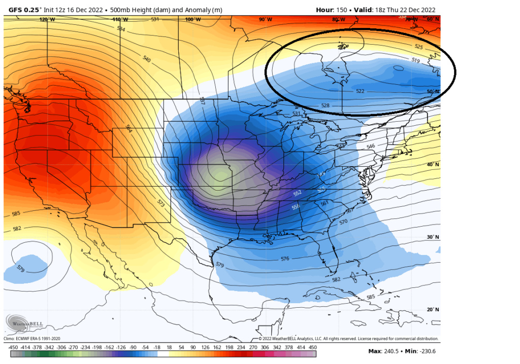
I hear what your saying and we are still pretty far out in time so Im not jumping yet. The biggest difference is really the area in SE Canada. There is an ULL creating some confluence in the NE on the GFS where as the Euro and CMC do not.
_________________
"In weather and in life, there's no winning and losing; there's only winning and learning."
WINTER 2012/2013 TOTALS 43.65"WINTER 2017/2018 TOTALS 62.85" WINTER 2022/2023 TOTALS 4.9"
WINTER 2013/2014 TOTALS 64.85"WINTER 2018/2019 TOTALS 14.25" WINTER 2023/2024 TOTALS 13.1"
WINTER 2014/2015 TOTALS 71.20"WINTER 2019/2020 TOTALS 6.35"
WINTER 2015/2016 TOTALS 35.00"WINTER 2020/2021 TOTALS 37.75"
WINTER 2016/2017 TOTALS 42.25"WINTER 2021/2022 TOTALS 31.65"

sroc4- Admin

- Posts : 8443
Reputation : 302
Join date : 2013-01-07
Location : Wading River, LI
heehaw453 likes this post
 Re: Long Range Thread 25.0
MOG the 12z GFS is drool worthy.

jmanley32- Senior Enthusiast

- Posts : 20635
Reputation : 108
Join date : 2013-12-12
Age : 43
Location : Yonkers, NY
Page 13 of 40 •  1 ... 8 ... 12, 13, 14 ... 26 ... 40
Page 13 of 40
Permissions in this forum:
You cannot reply to topics in this forum|
|
|

 Home
Home