Long Range Thread 25.0
+42
toople
Coachgriff
Carvin
Scullybutcher
Wheezer
lglickman1
dolphins222
Grselig
Zhukov1945
aiannone
CPcantmeasuresnow
jimv45
JT33
TheAresian
Radz
brownie
SENJsnowman
billg315
hyde345
SoulSingMG
Math23x7
phil155
snowbunny
mmanisca
Abba701
MattyICE
GreyBeard
nutleyblizzard
heehaw453
weatherwatchermom
HectorO
jmanley32
Irish
dkodgis
Dunnzoo
sroc4
algae888
Frank_Wx
kalleg
frank 638
docstox12
amugs
46 posters
Page 38 of 40
Page 38 of 40 •  1 ... 20 ... 37, 38, 39, 40
 Re: Long Range Thread 25.0
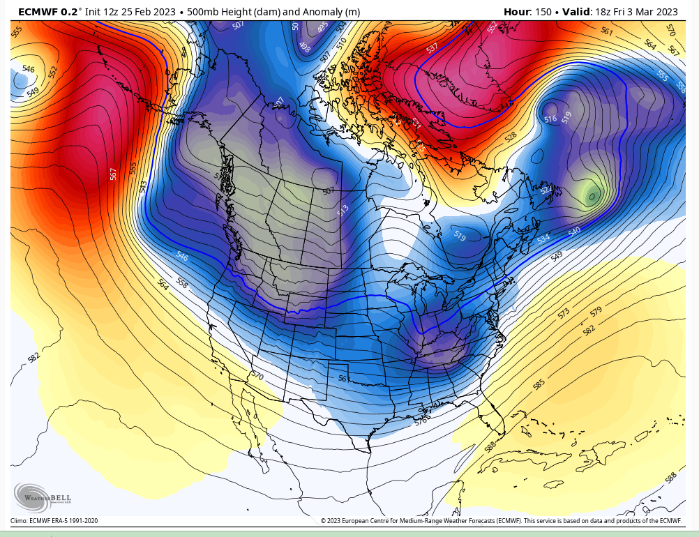
Also interesting because we are on the cusp (supposedly) of this pattern change. One wonders if a big storm could be what heralds that change.
billg315- Advanced Forecaster - Mod

- Posts : 4555
Join date : 2015-01-24
heehaw453- Advanced Forecaster

- Posts : 3931
Join date : 2014-01-20
sroc4 likes this post
 Re: Long Range Thread 25.0
The block, a true West NAO and a 50/50 are key
_________________
Mugs
AKA:King: Snow Weenie
Self Proclaimed
WINTER 2014-15 : 55.12" +.02 for 6 coatings (avg. 35")
WINTER 2015-16 Total - 29.8" (Avg 35")
WINTER 2016-17 : 39.5" so far

amugs- Advanced Forecaster - Mod

- Posts : 15147
Reputation : 213
Join date : 2013-01-07
Age : 54
Location : Hillsdale,NJ
sroc4, CPcantmeasuresnow and heehaw453 like this post
 Re: Long Range Thread 25.0
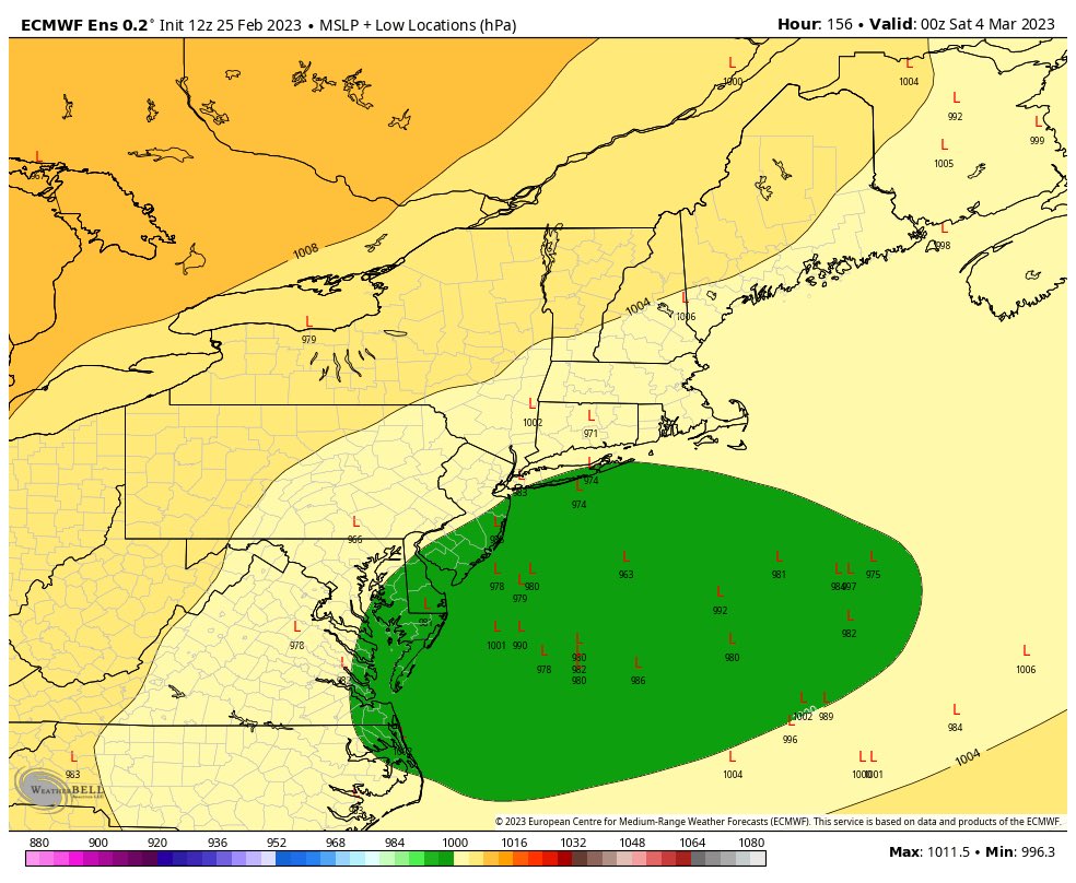
Very interesting setup for this. Of course, unlike prior storms cutting to the GL, the bigger risk here might be this thing scooting by to our south. Wouldn't that be a kick in the you know what after all the cutters this winter?

billg315- Advanced Forecaster - Mod

- Posts : 4555
Reputation : 185
Join date : 2015-01-24
Age : 50
Location : Flemington, NJ
heehaw453- Advanced Forecaster

- Posts : 3931
Reputation : 86
Join date : 2014-01-20
Location : Bedminster Township, PA Elevation 600' ASL
CPcantmeasuresnow, kalleg, essexcountypete and billg315 like this post

billg315- Advanced Forecaster - Mod

- Posts : 4555
Reputation : 185
Join date : 2015-01-24
Age : 50
Location : Flemington, NJ
 Re: Long Range Thread 25.0
We have a JIM WITT beastly storm next weekend. Been saying for weeks here.
Book it..cyclogenesis!!
Book it..cyclogenesis!!
_________________
Mugs
AKA:King: Snow Weenie
Self Proclaimed
WINTER 2014-15 : 55.12" +.02 for 6 coatings (avg. 35")
WINTER 2015-16 Total - 29.8" (Avg 35")
WINTER 2016-17 : 39.5" so far

amugs- Advanced Forecaster - Mod

- Posts : 15147
Reputation : 213
Join date : 2013-01-07
Age : 54
Location : Hillsdale,NJ
 Re: Long Range Thread 25.0
hopefully it’s a big oneamugs wrote:We have a JIM WITT beastly storm next weekend. Been saying for weeks here.
Book it..cyclogenesis!!
frank 638- Senior Enthusiast

- Posts : 2878
Reputation : 37
Join date : 2016-01-01
Age : 41
Location : bronx ny
 Re: Long Range Thread 25.0
_________________
Mugs
AKA:King: Snow Weenie
Self Proclaimed
WINTER 2014-15 : 55.12" +.02 for 6 coatings (avg. 35")
WINTER 2015-16 Total - 29.8" (Avg 35")
WINTER 2016-17 : 39.5" so far

amugs- Advanced Forecaster - Mod

- Posts : 15147
Reputation : 213
Join date : 2013-01-07
Age : 54
Location : Hillsdale,NJ
 Re: Long Range Thread 25.0
This situation is kind of like the game shows where you have one decent prize in hand (like a big screen TV) and a second prize hidden behind the door. Monday is a nice little event if it pans out (the prize in hand), but you just can't take your eye off that other door knowing there might be a sleek sports car behind it. Of course it's possible when the door opens, the prize is just a set of kitchen knives.
I think this Friday system has the potential to be a blockbuster for us and I keep looking away from Monday and toward Friday. But . . . I'm very worried that when it arrives, I'll just be going home with kitchen knives.
Let's hope this all comes together because we could use one of those big March storms that have occurred many times in this region.

billg315- Advanced Forecaster - Mod

- Posts : 4555
Reputation : 185
Join date : 2015-01-24
Age : 50
Location : Flemington, NJ
CPcantmeasuresnow, Radz, kalleg, essexcountypete, dkodgis and heehaw453 like this post
 Re: Long Range Thread 25.0
About next Friday. NAO -1, AO going neutral, and PNA rising to -.75 or so. As sure as I'm writing this if the block doesn't create enough confluence to deflect a strong ULL it will cut and be rain. No question. Normally blocking pinches on troughs underneath for confluence as opposed to injecting NS into an ULL. That s/w dynamic way too difficult right now to determine. So keep that in mind as the models swing back and forth.
heehaw453- Advanced Forecaster

- Posts : 3931
Reputation : 86
Join date : 2014-01-20
Location : Bedminster Township, PA Elevation 600' ASL
sroc4 and mmanisca like this post
 Re: Long Range Thread 25.0
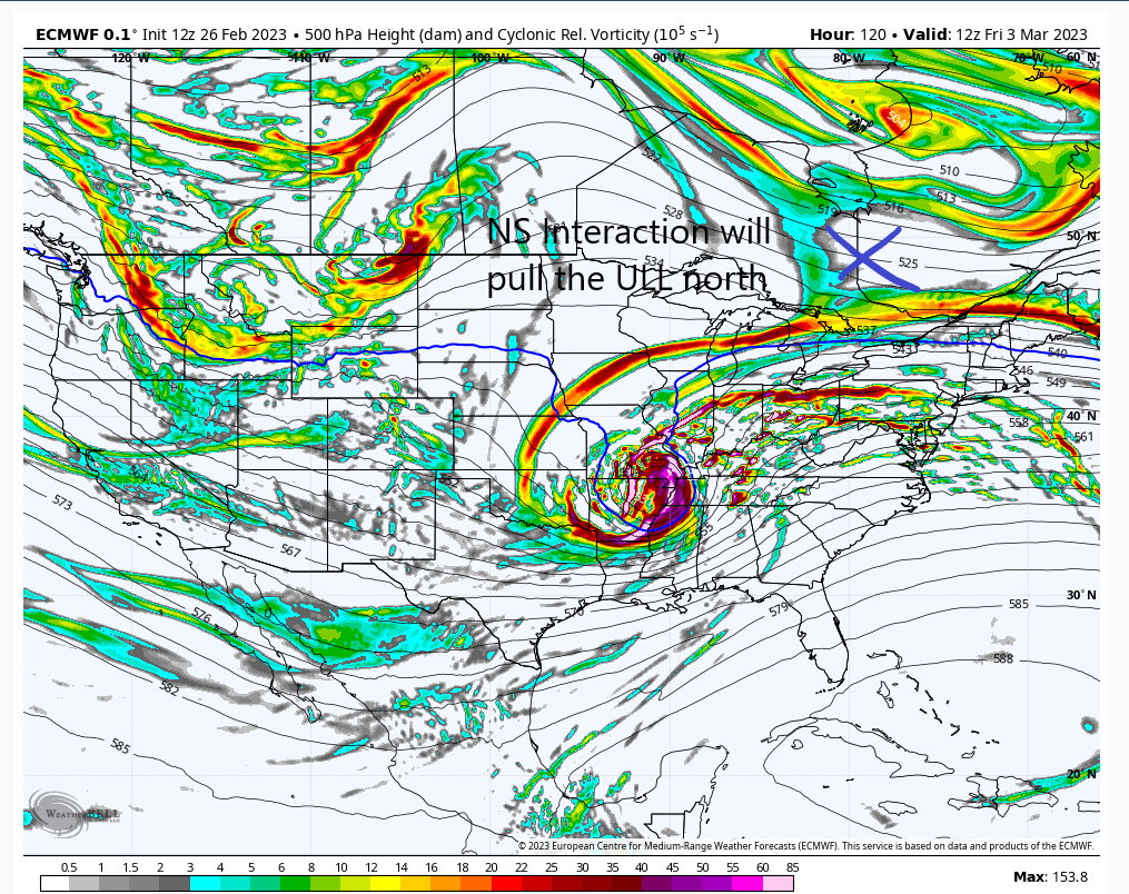
This 12Z Euro run demonstrates the NS interaction that instead of deflecting the ULL pulls in north far enough to mess things up. The ULL eventually opens up but it's too late. If you think models have a good handle on that complex a setup then think again. We will need at least until Wednesday to have confidence in this one. As always keep expectations low and there will be no disappointment.
edit: the blocking being less potent on this run most likely played a role in allowing the NS to interact instead of pushing down on the ULL like it did the previous run.
edit: the blocking being less potent on this run most likely played a role in allowing the NS to interact instead of pushing down on the ULL like it did the previous run.

heehaw453- Advanced Forecaster

- Posts : 3931
Reputation : 86
Join date : 2014-01-20
Location : Bedminster Township, PA Elevation 600' ASL
 Re: Long Range Thread 25.0
I lied lol im liking what im hearing so far but some big words being thrown out there one being blockbuster. Mugs i wont deny you of tel call these into existance. What i forget is you cant posdibly call imby or exact 100 mile etc differences. I will do as scott says cautioys optimism. Sorry for my momrnt of dispair it really actually isnt about the snow lots of stressors in my life right now that will hopefully calm down by april. Ill try keep myself in check here. Hell ive been able do it all season. Even cp has kept himself pretty cool. Like my mom says it is whay it is. You cant fret sbout things you cant control. Weather is def one those things.

jmanley32- Senior Enthusiast

- Posts : 20645
Reputation : 108
Join date : 2013-12-13
Age : 43
Location : Yonkers, NY
WinterColdandSnowisamyth likes this post
 Re: Long Range Thread 25.0
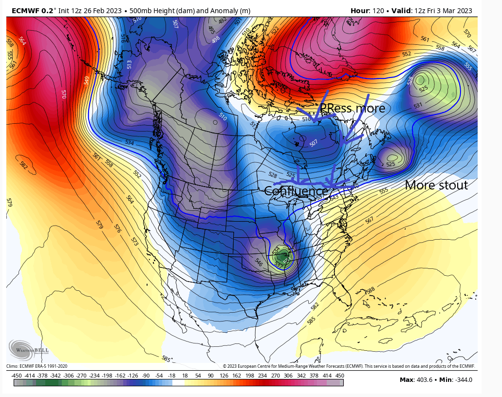
PRESS BABY PRESS!! Here it goes again. Hope this continues!!
You can sew how over the past few runs the N NAO and Confluence press shoves the LP SouthEast as the blue colors the press buds over SE CANADA and Main3 .....again..

You can sew how over the past few runs the N NAO and Confluence press shoves the LP SouthEast as the blue colors the press buds over SE CANADA and Main3 .....again..

_________________
Mugs
AKA:King: Snow Weenie
Self Proclaimed
WINTER 2014-15 : 55.12" +.02 for 6 coatings (avg. 35")
WINTER 2015-16 Total - 29.8" (Avg 35")
WINTER 2016-17 : 39.5" so far

amugs- Advanced Forecaster - Mod

- Posts : 15147
Reputation : 213
Join date : 2013-01-07
Age : 54
Location : Hillsdale,NJ
MattyICE likes this post
 Re: Long Range Thread 25.0
amugs wrote:PRESS BABY PRESS!! Here it goes again. Hope this continues!!
You can sew how over the past few runs the N NAO and Confluence press shoves the LP SouthEast as the blue colors the press buds over SE CANADA and Main3 .....again..
I have a feeling about this one, Mugs. I think I like the wiggle room. Meaning, this will be a strong and wet system with tons of moisture surging out ahead almost SWFE style. So maybe it does end up cutting eventually and you taint but not until after a good thump then some sleet.
MattyICE- Advanced Forecaster

- Posts : 249
Reputation : 6
Join date : 2017-11-10
Age : 39
Location : Clifton, NJ (Eastern Passaic County)
 Re: Long Range Thread 25.0
It's possible. The block is going to be key as well as NS s/w interaction with the ULL in TN Valley. We need the trough to be squeezed more which will blow the ULL open faster which then forces LP further SE. Otherwise there is too much space and strength to come north. I never bet against a decent block, but I'd like to see a more stout 50/50 too will lower heights on the EC. Right now I'm neutral on this.MattyICE wrote:amugs wrote:PRESS BABY PRESS!! Here it goes again. Hope this continues!!
You can sew how over the past few runs the N NAO and Confluence press shoves the LP SouthEast as the blue colors the press buds over SE CANADA and Main3 .....again..
I have a feeling about this one, Mugs. I think I like the wiggle room. Meaning, this will be a strong and wet system with tons of moisture surging out ahead almost SWFE style. So maybe it does end up cutting eventually and you taint but not until after a good thump then some sleet.
heehaw453- Advanced Forecaster

- Posts : 3931
Reputation : 86
Join date : 2014-01-20
Location : Bedminster Township, PA Elevation 600' ASL
MattyICE and WinterColdandSnowisamyth like this post
 Re: Long Range Thread 25.0
Snow opportunities through the endish of March with a N NAO, EPO and WPO forming around the 7-10th timeframe and running for a solid 2 weeks.


_________________
Mugs
AKA:King: Snow Weenie
Self Proclaimed
WINTER 2014-15 : 55.12" +.02 for 6 coatings (avg. 35")
WINTER 2015-16 Total - 29.8" (Avg 35")
WINTER 2016-17 : 39.5" so far

amugs- Advanced Forecaster - Mod

- Posts : 15147
Reputation : 213
Join date : 2013-01-07
Age : 54
Location : Hillsdale,NJ
 Re: Long Range Thread 25.0
amugs wrote:Snow opportunities through the endish of March with a N NAO, EPO and WPO forming around the 7-10th timeframe and running for a solid 2 weeks.
Steady there partner. Let’s get one in the books before we start talking about several.
WinterColdandSnowisamyth- Posts : 23
Reputation : 0
Join date : 2023-02-26
 Re: Long Range Thread 25.0
What is the potential for the Friday storm if all goes right? I realize there's also the cutter potential all rain, and wind driven at that looks like a much more powerful system either way.

jmanley32- Senior Enthusiast

- Posts : 20645
Reputation : 108
Join date : 2013-12-13
Age : 43
Location : Yonkers, NY
frank 638 likes this post
 Re: Long Range Thread 25.0
Model guidance so far just doesn't look positive for Friday. Can't throw in the towel yet as there are subtle things to affect the ULL strength and trajectory. I'm giving it until Wednesday to start seeing something more positive than what I see now.
heehaw453- Advanced Forecaster

- Posts : 3931
Reputation : 86
Join date : 2014-01-20
Location : Bedminster Township, PA Elevation 600' ASL
 Re: Long Range Thread 25.0
One of the few times I’m liking the weekend Friday trend!!! Gotta get that baby shower in!heehaw453 wrote:Model guidance so far just doesn't look positive for Friday. Can't throw in the towel yet as there are subtle things to affect the ULL strength and trajectory. I'm giving it until Wednesday to start seeing something more positive than what I see now.

mmanisca- Pro Enthusiast

- Posts : 299
Reputation : 3
Join date : 2013-01-23
Age : 66
Location : Deer Park, Long Island
docstox12 likes this post
 Re: Long Range Thread 25.0
mmanisca wrote:One of the few times I’m liking the weekend Friday trend!!! Gotta get that baby shower in!heehaw453 wrote:Model guidance so far just doesn't look positive for Friday. Can't throw in the towel yet as there are subtle things to affect the ULL strength and trajectory. I'm giving it until Wednesday to start seeing something more positive than what I see now.
Thoughts like this should probably be kept internal on most weather sites LOL.
WinterColdandSnowisamyth- Posts : 23
Reputation : 0
Join date : 2023-02-26
mmanisca, essexcountypete and jmanley32 like this post
 Re: Long Range Thread 25.0
Not to be the bearer of bad news but I’m not thrilled with the end of the week set up at all. Not entirely going to throw in the towel but I’m expecting this not to work out.
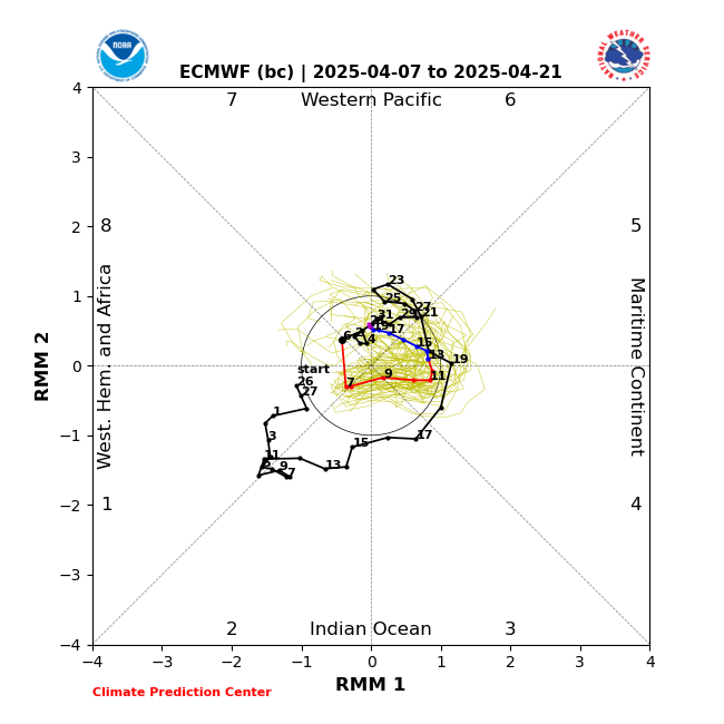
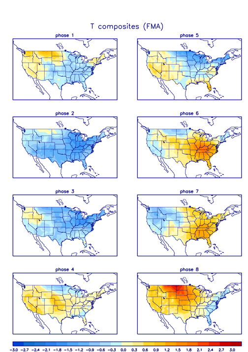
SOI has remained in the positive and our MJO is coming out into phase 6-7 with amplitude. This time of year warm phases. No way around it. It does appear that the MJO forecast does make it to 8 which favors colder airmass, but not until after this weekend. As a result the big picture of the La Niña base state background combined with unfavorable MJO makes me think there won’t be enough resistance in the atmosphere to prevent this next one from amplifying over the center of the CONUS, pumping the SE ridge, allowing it to cut to the west driving in the warm surface and mid levels(our winter pattern all season).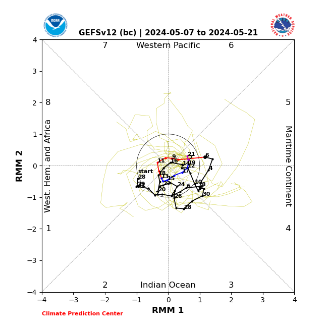
There is an HP to the north at the onset so maybe some of us, N&W favored, can eke out some front end before changing over.
Anyway that’s the quick analysis. Like I said I’m not ready to throw the towel but it’s in my hand.
SOI has remained in the positive and our MJO is coming out into phase 6-7 with amplitude. This time of year warm phases. No way around it. It does appear that the MJO forecast does make it to 8 which favors colder airmass, but not until after this weekend. As a result the big picture of the La Niña base state background combined with unfavorable MJO makes me think there won’t be enough resistance in the atmosphere to prevent this next one from amplifying over the center of the CONUS, pumping the SE ridge, allowing it to cut to the west driving in the warm surface and mid levels(our winter pattern all season).


There is an HP to the north at the onset so maybe some of us, N&W favored, can eke out some front end before changing over.
Anyway that’s the quick analysis. Like I said I’m not ready to throw the towel but it’s in my hand.
_________________
"In weather and in life, there's no winning and losing; there's only winning and learning."
WINTER 2012/2013 TOTALS 43.65"WINTER 2017/2018 TOTALS 62.85" WINTER 2022/2023 TOTALS 4.9"
WINTER 2013/2014 TOTALS 64.85"WINTER 2018/2019 TOTALS 14.25" WINTER 2023/2024 TOTALS 13.1"
WINTER 2014/2015 TOTALS 71.20"WINTER 2019/2020 TOTALS 6.35" WINTER 2024/2025 TOTALS 0.00
WINTER 2015/2016 TOTALS 35.00"WINTER 2020/2021 TOTALS 37.75"
WINTER 2016/2017 TOTALS 42.25"WINTER 2021/2022 TOTALS 31.65"

sroc4- Admin

- Posts : 8458
Reputation : 302
Join date : 2013-01-07
Location : Wading River, LI
mmanisca likes this post
 Re: Long Range Thread 25.0
Agreed. It’s not looking great right now. So looks like the kitchen knives are probably behind that door (for reference see my above post. Lol)

billg315- Advanced Forecaster - Mod

- Posts : 4555
Reputation : 185
Join date : 2015-01-24
Age : 50
Location : Flemington, NJ
sroc4 likes this post
heehaw453- Advanced Forecaster

- Posts : 3931
Reputation : 86
Join date : 2014-01-20
Location : Bedminster Township, PA Elevation 600' ASL
docstox12 likes this post
 Re: Long Range Thread 25.0
From the End Thump after confluence builds not a stretch before th3 mix and changeover. Small window left so let's see  .
.
MJO goes sick mode in Phase 8. Where was this in Jan and Feb??


That is a very strong Phase 8 which would lead to a cold period and possible snowy timeframe if storms come about for our region. Nothing guaranteed but promising especially with wavelengths and past history of March storms.
If it can get into Phase 1 that is even better than 8 for March. It's like Phase 8 in Jan/Feb.
MJO goes sick mode in Phase 8. Where was this in Jan and Feb??


That is a very strong Phase 8 which would lead to a cold period and possible snowy timeframe if storms come about for our region. Nothing guaranteed but promising especially with wavelengths and past history of March storms.
If it can get into Phase 1 that is even better than 8 for March. It's like Phase 8 in Jan/Feb.
_________________
Mugs
AKA:King: Snow Weenie
Self Proclaimed
WINTER 2014-15 : 55.12" +.02 for 6 coatings (avg. 35")
WINTER 2015-16 Total - 29.8" (Avg 35")
WINTER 2016-17 : 39.5" so far

amugs- Advanced Forecaster - Mod

- Posts : 15147
Reputation : 213
Join date : 2013-01-07
Age : 54
Location : Hillsdale,NJ
 Re: Long Range Thread 25.0
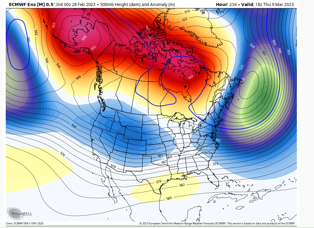
Yeah the window starting 3/09 is probably the last window of the season and maybe the most promising. Full link ridge PAC to Atlantic and plugged up Atlantic stockpiling low pressures to spin in the 50/50. SER beaten down in response to the 50/50 roadblock. Any s/w that develops would probably have a tough time moving and that could lead to something significant. As always at this lead time be cautious, but does look interesting until it doesn't anymore of course. This window very well determine whether record futility snowfall occurs or not. Definitely IMBY it will.

heehaw453- Advanced Forecaster

- Posts : 3931
Reputation : 86
Join date : 2014-01-20
Location : Bedminster Township, PA Elevation 600' ASL
CPcantmeasuresnow likes this post
Page 38 of 40 •  1 ... 20 ... 37, 38, 39, 40
Page 38 of 40
Permissions in this forum:
You cannot reply to topics in this forum
 Home
Home