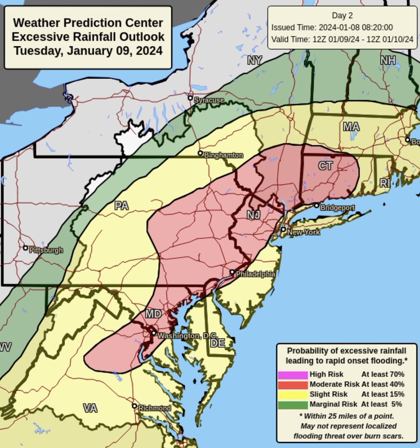
JAN 9th-10th Flooding Threat
Page 3 of 18 •  1, 2, 3, 4 ... 10 ... 18
 Re: JAN 9th-10th Flooding Threat
jmanley32 wrote:Didn't mention them cuz as you said you have a HWW, I dunno what engraved invitation Upton is waiting for, literally HWW all way to south of NYC (Atlantic city I believe) then nothing then LI and RI/MA. NYC area, coastal CT have nothing, As i said guess they may be waiting to see if the inversion might allow for those insane numbers to verify.weatherwatchermom wrote:And you don't think the Jersey coast?? LOL we already have high winter watch posted..jmanley32 wrote:yikes! Why do you think The NWS has not issued wind headlines for NE NJ, Westchester/NYC and coastal CT? Even inland this is going to be advisory criteria, I thing HWW for all coastal and the areas I just mentioned. if winds hit 70-80 MPH even 60-70 there is going to be massive outages.amugs wrote:He's beenspot on the last number of storms and makes valid pts.MONSTER WINDS TUESDAY NIGHT.. MULTI-STATE WIND DAMAGE THREAT
— Mike Masco (@MikeMasco) January 8, 2024
Here we are again! We are at another cross roads on whether to accept the idea of a 70-80mph wind gust potential from MD to ME!
Wind forecasting is a big challenge as a forecaster needs to factor in how much wind… pic.twitter.com/c5VRvXLsdW
Easy jman, they are late quite often on watches, warnings etc. No news is good news, if they haven't issued one yet, they aren't concerned yet. We are still 24 hours away from start time, there is plenty of time to put out additional watches/warnings. I would rather they take their time and get it right then go early and have to retract or adjust.
Dunnzoo- Senior Enthusiast - Mod

- Posts : 4939
Join date : 2013-01-11
Frank_Wx likes this post
 Re: JAN 9th-10th Flooding Threat
amugs wrote:Ida 2.0 peeps, prepare the ark and the generators is all I am saying. call it hype or what you want but models are noty backing down from winds nor flooding potentital.
Jersey shore will have possible moderate to major coastal flooding as well. Upton playing politicas again by utter silence or waiting?
SE winds will rake the area 40 -50 MPH inland and LI and Jersey Shore up to 65/70mph is not out of the question.
Unless we see models backing off this is a worry.
NNJ does not do well with SE winds nor does the shore.
The bolded/italicized point is extremely poignant, and I was just talking to a friend/employer of mine who owns a tree service about this. Our climatological wind direction is west-northwest, so trees are used to added stress from that direction and grow accordingly. However, this will have an anomalous southerly/easterly component, which, if the wind potential is realized, will result in additional damage that we wouldn’t otherwise see if it was west-northwest wind, because that is the weaker side of the tree’s fibers. This goes for everywhere north and west of I-95. A secondary factor is that we have snow load up here.
rb924119- Meteorologist

- Posts : 7119
Join date : 2013-02-06
 Re: JAN 9th-10th Flooding Threat
True but we are within 24 hrs now, I doubt this is backed off on by models. I just don't understand why they did not wait for all their coverage area's and do it all at once, at the very least there will be wind advisory level winds but IMO HWW, NYC coastal CT and southern westchester are basically the coast too. But we have no choice to wait and see. Its not like there will be a glass globe over NYC area and CT shore lolDunnzoo wrote:jmanley32 wrote:Didn't mention them cuz as you said you have a HWW, I dunno what engraved invitation Upton is waiting for, literally HWW all way to south of NYC (Atlantic city I believe) then nothing then LI and RI/MA. NYC area, coastal CT have nothing, As i said guess they may be waiting to see if the inversion might allow for those insane numbers to verify.weatherwatchermom wrote:And you don't think the Jersey coast?? LOL we already have high winter watch posted..jmanley32 wrote:yikes! Why do you think The NWS has not issued wind headlines for NE NJ, Westchester/NYC and coastal CT? Even inland this is going to be advisory criteria, I thing HWW for all coastal and the areas I just mentioned. if winds hit 70-80 MPH even 60-70 there is going to be massive outages.amugs wrote:He's beenspot on the last number of storms and makes valid pts.MONSTER WINDS TUESDAY NIGHT.. MULTI-STATE WIND DAMAGE THREAT
— Mike Masco (@MikeMasco) January 8, 2024
Here we are again! We are at another cross roads on whether to accept the idea of a 70-80mph wind gust potential from MD to ME!
Wind forecasting is a big challenge as a forecaster needs to factor in how much wind… pic.twitter.com/c5VRvXLsdW
Easy jman, they are late quite often on watches, warnings etc. No news is good news, if they haven't issued one yet, they aren't concerned yet. We are still 24 hours away from start time, there is plenty of time to put out additional watches/warnings. I would rather they take their time and get it right then go early and have to retract or adjust.
Last edited by jmanley32 on Mon Jan 08, 2024 1:57 pm; edited 1 time in total

jmanley32- Senior Enthusiast

- Posts : 20648
Reputation : 108
Join date : 2013-12-12
Age : 43
Location : Yonkers, NY
 Re: JAN 9th-10th Flooding Threat
Ida had no wind but rainfall wise could be.rb924119 wrote:amugs wrote:Ida 2.0 peeps, prepare the ark and the generators is all I am saying. call it hype or what you want but models are noty backing down from winds nor flooding potentital.
Jersey shore will have possible moderate to major coastal flooding as well. Upton playing politicas again by utter silence or waiting?
SE winds will rake the area 40 -50 MPH inland and LI and Jersey Shore up to 65/70mph is not out of the question.
Unless we see models backing off this is a worry.
NNJ does not do well with SE winds nor does the shore.
The bolded/italicized point is extremely poignant, and I was just talking to a friend/employer of mine who owns a tree service about this. Our climatological wind direction is west-northwest, so trees are used to added stress from that direction and grow accordingly. However, this will have an anomalous southerly/easterly component, which, if the wind potential is realized, will result in additional damage that we wouldn’t otherwise see if it was west-northwest wind, because that is the weaker side of the tree’s fibers. This goes for everywhere north and west of I-95. A secondary factor is that we have snow load up here.
Just N/W of NYC or the coast? I presume you mean both. That is a very interesting fact.

jmanley32- Senior Enthusiast

- Posts : 20648
Reputation : 108
Join date : 2013-12-12
Age : 43
Location : Yonkers, NY
 Re: JAN 9th-10th Flooding Threat
jmanley32 wrote:Ida had no wind but rainfall wise could be.rb924119 wrote:amugs wrote:Ida 2.0 peeps, prepare the ark and the generators is all I am saying. call it hype or what you want but models are noty backing down from winds nor flooding potentital.
Jersey shore will have possible moderate to major coastal flooding as well. Upton playing politicas again by utter silence or waiting?
SE winds will rake the area 40 -50 MPH inland and LI and Jersey Shore up to 65/70mph is not out of the question.
Unless we see models backing off this is a worry.
NNJ does not do well with SE winds nor does the shore.
The bolded/italicized point is extremely poignant, and I was just talking to a friend/employer of mine who owns a tree service about this. Our climatological wind direction is west-northwest, so trees are used to added stress from that direction and grow accordingly. However, this will have an anomalous southerly/easterly component, which, if the wind potential is realized, will result in additional damage that we wouldn’t otherwise see if it was west-northwest wind, because that is the weaker side of the tree’s fibers. This goes for everywhere north and west of I-95. A secondary factor is that we have snow load up here.
Just N/W of NYC or the coast? I presume you mean both. That is a very interesting fact.
Not so much the coast because they see strong anomalous southerly/easterly winds a lot more often than inland. However, as mugs pointed out, their concern comes from flooding with the anomalous easterly component.
rb924119- Meteorologist

- Posts : 7119
Reputation : 195
Join date : 2013-02-06
Age : 32
Location : Greentown, Pa
 Re: JAN 9th-10th Flooding Threat
rb924119- Meteorologist

- Posts : 7119
Reputation : 195
Join date : 2013-02-06
Age : 32
Location : Greentown, Pa
 Re: JAN 9th-10th Flooding Threat
Interesting usually that is the opposite. I guess I am considered inland, coast I dunno. It is subjective at times.rb924119 wrote:I’m not saying that there wouldn’t be any tree damage, but relative to averages, the risk is somewhat moderated compared to inland.

jmanley32- Senior Enthusiast

- Posts : 20648
Reputation : 108
Join date : 2013-12-12
Age : 43
Location : Yonkers, NY
 Re: JAN 9th-10th Flooding Threat
_________________
Mugs
AKA:King: Snow Weenie
Self Proclaimed
WINTER 2014-15 : 55.12" +.02 for 6 coatings (avg. 35")
WINTER 2015-16 Total - 29.8" (Avg 35")
WINTER 2016-17 : 39.5" so far

amugs- Advanced Forecaster - Mod

- Posts : 15164
Reputation : 213
Join date : 2013-01-07
Age : 54
Location : Hillsdale,NJ
 Re: JAN 9th-10th Flooding Threat
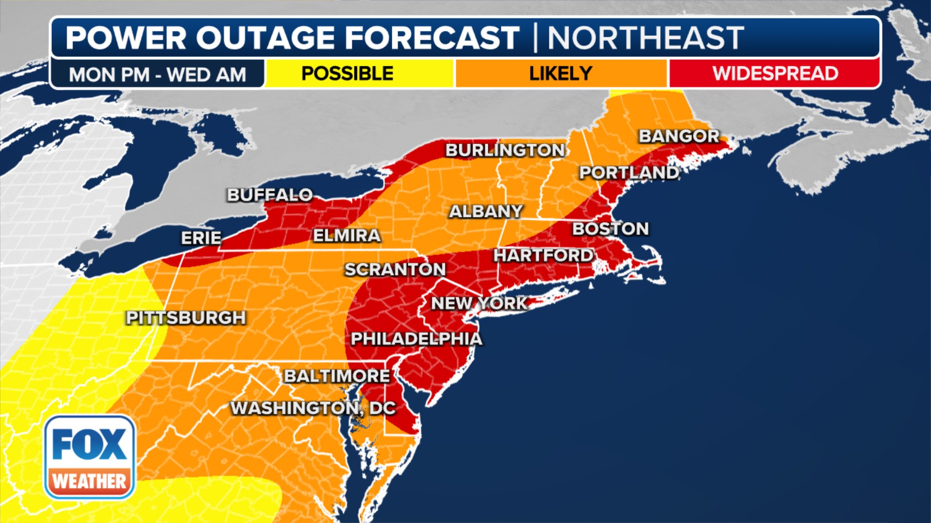
Thanks I have been trying to find a map that points out the areas that could have outages, I may not be working from home if power goes out ugg and parkways will likely be flooded so either way Wed morning is go be nightmare. Kinda crazy how the 3km NAM is being taken more seriously with it's wind map (yeah I get it may be overdone but talking 70-80 is even crazy. Other than TS we have not seen that with a cutter.amugs wrote:This may come to fruition but better to be prepared than prepare for the failure!!

jmanley32- Senior Enthusiast

- Posts : 20648
Reputation : 108
Join date : 2013-12-12
Age : 43
Location : Yonkers, NY
 Re: JAN 9th-10th Flooding Threat

jmanley32- Senior Enthusiast

- Posts : 20648
Reputation : 108
Join date : 2013-12-12
Age : 43
Location : Yonkers, NY
 Re: JAN 9th-10th Flooding Threat
phil155- Pro Enthusiast

- Posts : 497
Reputation : 4
Join date : 2019-12-16
 Re: JAN 9th-10th Flooding Threat
phil155 wrote:I was just on tropical tidbits and looking at the meso models and I am not seeing the type of winds you guys are discussing with the exception of LI and maybe right along the coast, is there a different site I should use? Not doubting what everyone is saying just wondering if maybe tropical tidbits being a free site does not have the level of detail necessary to see everything
TT does not have wind maps like WXBell or Pivotal Wx subscriptions my man.
_________________
Mugs
AKA:King: Snow Weenie
Self Proclaimed
WINTER 2014-15 : 55.12" +.02 for 6 coatings (avg. 35")
WINTER 2015-16 Total - 29.8" (Avg 35")
WINTER 2016-17 : 39.5" so far

amugs- Advanced Forecaster - Mod

- Posts : 15164
Reputation : 213
Join date : 2013-01-07
Age : 54
Location : Hillsdale,NJ
phil155 likes this post
 Re: JAN 9th-10th Flooding Threat
amugs wrote:phil155 wrote:I was just on tropical tidbits and looking at the meso models and I am not seeing the type of winds you guys are discussing with the exception of LI and maybe right along the coast, is there a different site I should use? Not doubting what everyone is saying just wondering if maybe tropical tidbits being a free site does not have the level of detail necessary to see everything
TT does not have wind maps like WXBell or Pivotal Wx subscriptions my man.
Cool, Thanks I will check them out
phil155- Pro Enthusiast

- Posts : 497
Reputation : 4
Join date : 2019-12-16
 Re: JAN 9th-10th Flooding Threat
Sadly not free and fairly expensive especially wxbell.phil155 wrote:amugs wrote:phil155 wrote:I was just on tropical tidbits and looking at the meso models and I am not seeing the type of winds you guys are discussing with the exception of LI and maybe right along the coast, is there a different site I should use? Not doubting what everyone is saying just wondering if maybe tropical tidbits being a free site does not have the level of detail necessary to see everything
TT does not have wind maps like WXBell or Pivotal Wx subscriptions my man.
Cool, Thanks I will check them out

jmanley32- Senior Enthusiast

- Posts : 20648
Reputation : 108
Join date : 2013-12-12
Age : 43
Location : Yonkers, NY
 Re: JAN 9th-10th Flooding Threat
jmanley32 wrote:Sadly not free and fairly expensive especially wxbell.phil155 wrote:amugs wrote:phil155 wrote:I was just on tropical tidbits and looking at the meso models and I am not seeing the type of winds you guys are discussing with the exception of LI and maybe right along the coast, is there a different site I should use? Not doubting what everyone is saying just wondering if maybe tropical tidbits being a free site does not have the level of detail necessary to see everything
TT does not have wind maps like WXBell or Pivotal Wx subscriptions my man.
Cool, Thanks I will check them out
Agreed
phil155- Pro Enthusiast

- Posts : 497
Reputation : 4
Join date : 2019-12-16
 Re: JAN 9th-10th Flooding Threat
https://www.weather.gov/media/okx/20240108_MajorstormSystemJan9_10_AMupdate.pdf

jmanley32- Senior Enthusiast

- Posts : 20648
Reputation : 108
Join date : 2013-12-12
Age : 43
Location : Yonkers, NY
 Re: JAN 9th-10th Flooding Threat
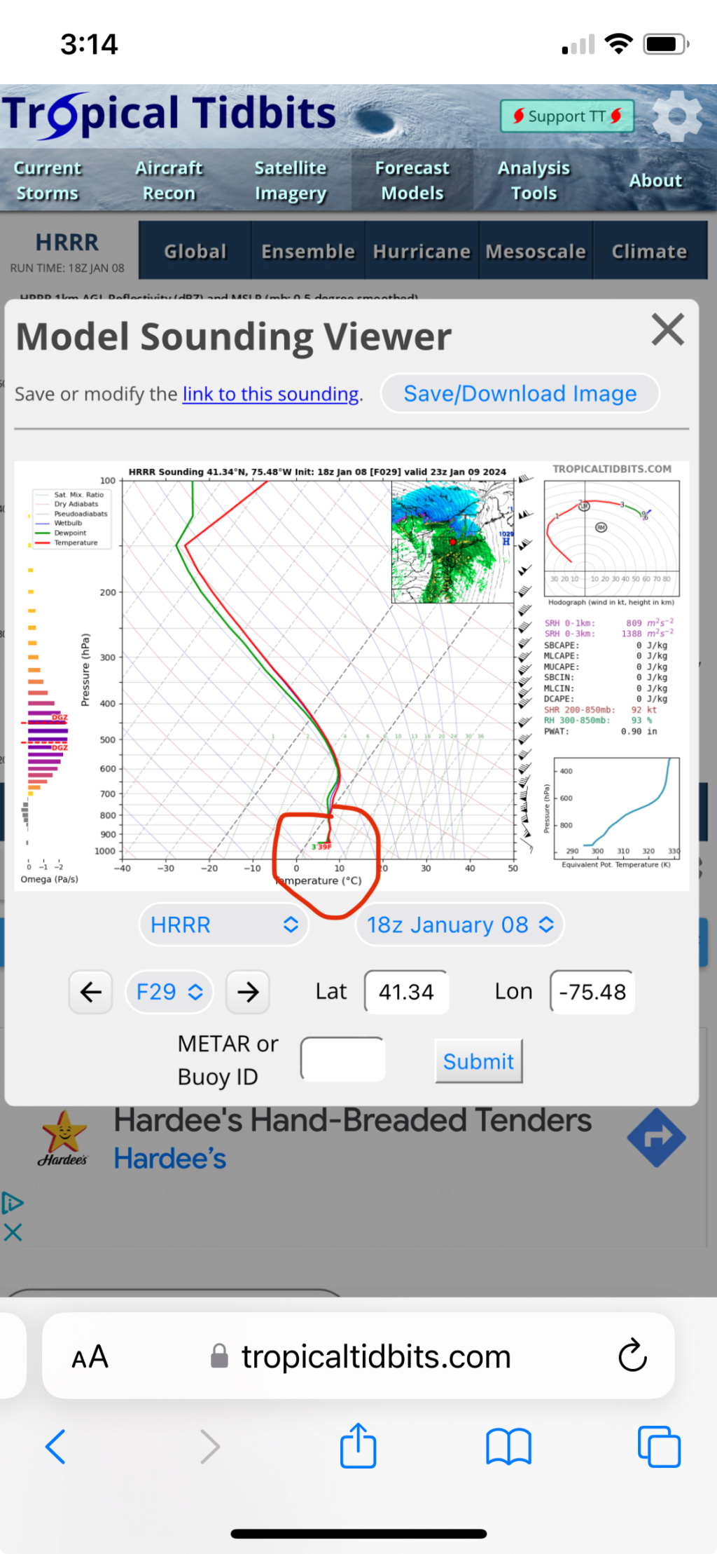
rb924119 wrote:I just took a quick look at some forecast soundings for my local area here in NEPA, and it doesn’t look good. AT ALL. However, with the snowpack, I’m hoping that it can help induce a stout extremely low-level inversion to help prevent mixing just long enough to allow the core of the strongest winds to pass overhead. I have to look at this more closely later. But I’m hoping the same thing can occur for everybody else that just got snow.
Here’s the HRRR picking up on my ideas; note the extreme inversion just above the surface for a local sounding in my area. This will be our only saving grace, but again, I don’t think this will be present along the coastal plain:
rb924119- Meteorologist

- Posts : 7119
Reputation : 195
Join date : 2013-02-06
Age : 32
Location : Greentown, Pa
 Re: JAN 9th-10th Flooding Threat
No idea how to read these would love to learn how, but the explanation is clear.rb924119 wrote:rb924119 wrote:I just took a quick look at some forecast soundings for my local area here in NEPA, and it doesn’t look good. AT ALL. However, with the snowpack, I’m hoping that it can help induce a stout extremely low-level inversion to help prevent mixing just long enough to allow the core of the strongest winds to pass overhead. I have to look at this more closely later. But I’m hoping the same thing can occur for everybody else that just got snow.
Here’s the HRRR picking up on my ideas; note the extreme inversion just above the surface for a local sounding in my area. This will be our only saving grace, but again, I don’t think this will be present along the coastal plain:

jmanley32- Senior Enthusiast

- Posts : 20648
Reputation : 108
Join date : 2013-12-12
Age : 43
Location : Yonkers, NY
 Re: JAN 9th-10th Flooding Threat
_________________
Janet
Snowfall winter of 2023-2024 17.5"
Snowfall winter of 2022-2023 6.0"
Snowfall winter of 2021-2022 17.6" 1" sleet 2/25/22
Snowfall winter of 2020-2021 51.1"
Snowfall winter of 2019-2020 8.5"
Snowfall winter of 2018-2019 25.1"
Snowfall winter of 2017-2018 51.9"
Snowfall winter of 2016-2017 45.6"
Snowfall winter of 2015-2016 29.5"
Snowfall winter of 2014-2015 50.55"
Snowfall winter of 2013-2014 66.5"
Dunnzoo- Senior Enthusiast - Mod

- Posts : 4939
Reputation : 68
Join date : 2013-01-11
Age : 62
Location : Westwood, NJ
 Re: JAN 9th-10th Flooding Threat

jmanley32- Senior Enthusiast

- Posts : 20648
Reputation : 108
Join date : 2013-12-12
Age : 43
Location : Yonkers, NY
 Re: JAN 9th-10th Flooding Threat
lol, i posted same exact time as you.Dunnzoo wrote:Wind Advisory issued jman.

jmanley32- Senior Enthusiast

- Posts : 20648
Reputation : 108
Join date : 2013-12-12
Age : 43
Location : Yonkers, NY
 Re: JAN 9th-10th Flooding Threat
Posted 4 minutes ago
URGENT - WEATHER MESSAGE
National Weather Service New York NY
318 PM EST Mon Jan 8 2024
NYZ074-075-078>081-176>179-091000-
/O.UPG.KOKX.HW.A.0001.240109T2300Z-240110T1100Z/
/O.NEW.KOKX.HW.W.0001.240109T2300Z-240110T1100Z/
Richmond (Staten Island)-Kings (Brooklyn)-Northwest Suffolk-
Northeast Suffolk-Southwest Suffolk-Southeast Suffolk-
Northern Queens-Northern Nassau-Southern Queens-Southern Nassau-
318 PM EST Mon Jan 8 2024
...HIGH WIND WARNING IN EFFECT FROM 6 PM TUESDAY TO 6 AM EST
WEDNESDAY...
* WHAT...Southeast winds 30 to 40 mph with gusts up to 60 mph
expected.
* WHERE...Richmond (Staten Island), Kings (Brooklyn), Northwest
Suffolk, Northeast Suffolk, Southwest Suffolk, Southeast
Suffolk, Northern Queens, Northern Nassau, Southern Queens and
Southern Nassau Counties.
* WHEN...From 6 PM Tuesday to 6 AM EST Wednesday.
* IMPACTS...Damaging winds will blow down trees and power lines.
Widespread power outages are expected. Travel will be
difficult, especially for high profile vehicles.
PRECAUTIONARY/PREPAREDNESS ACTIONS...
People should avoid being outside in forested areas and around
trees and branches. If possible, remain in the lower levels of
your home during the windstorm, and avoid windows. Use caution if
you must drive.
_________________
Mugs
AKA:King: Snow Weenie
Self Proclaimed
WINTER 2014-15 : 55.12" +.02 for 6 coatings (avg. 35")
WINTER 2015-16 Total - 29.8" (Avg 35")
WINTER 2016-17 : 39.5" so far

amugs- Advanced Forecaster - Mod

- Posts : 15164
Reputation : 213
Join date : 2013-01-07
Age : 54
Location : Hillsdale,NJ
 Re: JAN 9th-10th Flooding Threat
The highest wind potential continues to be across southeastern
portions of NYC metro and Long Island is where there is highest
potential for wind gusts near 60 mph Tuesday night. Farther
north and west, gusts are more limited to near 50 mph. May need
to expand the higher winds into coastal CT.

Grselig- Senior Enthusiast

- Posts : 1410
Reputation : 140
Join date : 2013-03-04
Age : 54
Location : Wayne NJ
 Re: JAN 9th-10th Flooding Threat
They did extend warning into coastal CT and all of new london county which is well inland (That county goes inland about 30+ miles) except the coastal part so that's interesting.Grselig wrote:As per discussion as to most damaging winds
The highest wind potential continues to be across southeastern
portions of NYC metro and Long Island is where there is highest
potential for wind gusts near 60 mph Tuesday night. Farther
north and west, gusts are more limited to near 50 mph. May need
to expand the higher winds into coastal CT.

jmanley32- Senior Enthusiast

- Posts : 20648
Reputation : 108
Join date : 2013-12-12
Age : 43
Location : Yonkers, NY
 Re: JAN 9th-10th Flooding Threat
_________________
_______________________________________________________________________________________________________
CLICK HERE to view NJ Strong Snowstorm Classifications
weatherwatchermom likes this post
SENJsnowman- Senior Enthusiast

- Posts : 1202
Reputation : 61
Join date : 2017-01-06
Age : 51
Location : Long Branch, NJ

jmanley32- Senior Enthusiast

- Posts : 20648
Reputation : 108
Join date : 2013-12-12
Age : 43
Location : Yonkers, NY
Page 3 of 18 •  1, 2, 3, 4 ... 10 ... 18

 Home
Home