Long Range Thread 28.0
+33
weatherwatchermom
essexcountypete
skinsfan1177
aiannone
larryrock72
Coachgriff
DAYBLAZER
nutleyblizzard
hyde345
docstox12
CPcantmeasuresnow
frank 638
Koroptim
HectorO
billg315
dkodgis
MattyICE
toople
sroc4
rb924119
Grselig
crippo84
phil155
Frank_Wx
jmanley32
NJBear
tomsriversnowstorm
Carvin
heehaw453
SENJsnowman
Irish
amugs
richb521
37 posters
Page 8 of 18
Page 8 of 18 •  1 ... 5 ... 7, 8, 9 ... 13 ... 18
 Re: Long Range Thread 28.0
Sorry, I just see it being too warm for the 12th-13th storm, likely mostly rain. After that we have more promise.
Irish- Pro Enthusiast

- Posts : 788
Join date : 2019-01-16
 Re: Long Range Thread 28.0
Last two GFS runs 00Z/06Z based on teleconnection/pattern is what I was thinking for this storm. Nothing has changed with the LW pattern only s/w interaction on Op models is what varies. The linking of n/s with Atlantic trough is going to be the key and that is supported by NAO/MJO you name it.
We shall see. Can't post graphics travelling...
We shall see. Can't post graphics travelling...
heehaw453- Advanced Forecaster

- Posts : 3906
Join date : 2014-01-20
phil155 likes this post
 Re: Long Range Thread 28.0
Keep the line tight and the rod tip up - reel this one in for us! NWS appears to be sniffing something with this too...
Model and ensemble trends turning colder and more amplified for
early next week after looking at 500mb height differences
between initializations of 00Z January 7th and 00Z January 8th.
500mb and 250mb height patterns transitioned from more zonal to
more trough like over the past 24 hours.
Model and ensemble trends turning colder and more amplified for
early next week after looking at 500mb height differences
between initializations of 00Z January 7th and 00Z January 8th.
500mb and 250mb height patterns transitioned from more zonal to
more trough like over the past 24 hours.

crippo84- Posts : 383
Reputation : 20
Join date : 2013-11-07
Age : 40
Location : East Village, NYC
kalleg likes this post
 Re: Long Range Thread 28.0
Crazy differences between the models right now…GFS has a solid shot of snow for the whole board….Euro and CMC are showing all rain for most of us and some light snow in the Catskills.

Coachgriff- Posts : 57
Reputation : 0
Join date : 2022-01-29
 Re: Long Range Thread 28.0
Coachgriff wrote:Crazy differences between the models right now…GFS has a solid shot of snow for the whole board….Euro and CMC are showing all rain for most of us and some light snow in the Catskills.
Surface differences seem like big ones, but 500mb (18-20,000 ft) the differences are more subtle, in timing strength and position. A wiggle here or there with any one of the features I outlined the other day will give you the drastic looking differences at the surface. Energy doesn't all come ashore until Sat the earliest.
_________________
"In weather and in life, there's no winning and losing; there's only winning and learning."
WINTER 2012/2013 TOTALS 43.65"WINTER 2017/2018 TOTALS 62.85" WINTER 2022/2023 TOTALS 4.9"
WINTER 2013/2014 TOTALS 64.85"WINTER 2018/2019 TOTALS 14.25" WINTER 2023/2024 TOTALS 13.1"
WINTER 2014/2015 TOTALS 71.20"WINTER 2019/2020 TOTALS 6.35"
WINTER 2015/2016 TOTALS 35.00"WINTER 2020/2021 TOTALS 37.75"
WINTER 2016/2017 TOTALS 42.25"WINTER 2021/2022 TOTALS 31.65"

sroc4- Admin

- Posts : 8389
Reputation : 302
Join date : 2013-01-07
Location : Wading River, LI
Coachgriff likes this post
 Re: Long Range Thread 28.0
crippo84 wrote:Keep the line tight and the rod tip up - reel this one in for us! NWS appears to be sniffing something with this too...
Model and ensemble trends turning colder and more amplified for
early next week after looking at 500mb height differences
between initializations of 00Z January 7th and 00Z January 8th.
500mb and 250mb height patterns transitioned from more zonal to
more trough like over the past 24 hours.
NWS for me is snow to rain to rain/snow so something is brewing.

docstox12- Wx Statistician Guru

- Posts : 8557
Reputation : 222
Join date : 2013-01-07
Age : 73
Location : Monroe NY
crippo84 likes this post
 Re: Long Range Thread 28.0
So to summarize:
6z GFS keeps the storm to our south, doesn't hook up with the northern stream energy, and South Jersey and the DelMarva get the heaviest snow (maybe 8-12") while we get more marginal snowfall totals (2-4") in Central and Northern NJ, with little or no snow north of NYC metro.
The last long Euro run (and the Canadian just for fun) has the storm develop too far north and without enough cold air so it is mainly rain with at best some light snow on the tail end and the heaviest snow stays to our north.
If you're someone who believes the truth usually lies somewhere in between I guess that would be great news for Central NJ up into NYC and LI. lol

billg315- Advanced Forecaster - Mod

- Posts : 4511
Reputation : 185
Join date : 2015-01-24
Age : 50
Location : Flemington, NJ
kalleg likes this post

billg315- Advanced Forecaster - Mod

- Posts : 4511
Reputation : 185
Join date : 2015-01-24
Age : 50
Location : Flemington, NJ
 Re: Long Range Thread 28.0
Something tell me after watching the 12z NAM come in there will be a new subtle wrinkle develop over the next few days.
_________________
"In weather and in life, there's no winning and losing; there's only winning and learning."
WINTER 2012/2013 TOTALS 43.65"WINTER 2017/2018 TOTALS 62.85" WINTER 2022/2023 TOTALS 4.9"
WINTER 2013/2014 TOTALS 64.85"WINTER 2018/2019 TOTALS 14.25" WINTER 2023/2024 TOTALS 13.1"
WINTER 2014/2015 TOTALS 71.20"WINTER 2019/2020 TOTALS 6.35"
WINTER 2015/2016 TOTALS 35.00"WINTER 2020/2021 TOTALS 37.75"
WINTER 2016/2017 TOTALS 42.25"WINTER 2021/2022 TOTALS 31.65"

sroc4- Admin

- Posts : 8389
Reputation : 302
Join date : 2013-01-07
Location : Wading River, LI
weatherwatchermom and billg315 like this post
 Re: Long Range Thread 28.0
12z GFS similar in output to the 6z GFS. Heaviest snow if anything is a bit further south with sharper cut-off on the north side.

billg315- Advanced Forecaster - Mod

- Posts : 4511
Reputation : 185
Join date : 2015-01-24
Age : 50
Location : Flemington, NJ
 Re: Long Range Thread 28.0
If the last two GFS runs came to fruition (and I think a lot of variables are still out there to shake things up with this forecast) our NJ Shore folks (are you listening SENJ Snowman??) would get a big time snowstorm out of this.

billg315- Advanced Forecaster - Mod

- Posts : 4511
Reputation : 185
Join date : 2015-01-24
Age : 50
Location : Flemington, NJ
docstox12, weatherwatchermom and SENJsnowman like this post
 Re: Long Range Thread 28.0
For what it's worth, the 12z Canadian is holding serve also with its prior runs. We have two camps presently: Euro and Canadian in one (more rain and snow primarily limited to the north); GFS in the other (colder but heavy snow suppressed mostly to the southern areas).

billg315- Advanced Forecaster - Mod

- Posts : 4511
Reputation : 185
Join date : 2015-01-24
Age : 50
Location : Flemington, NJ
 Re: Long Range Thread 28.0
If it snows to the south, good. They need their turn. But the high is mid 40s so …

dkodgis- Senior Enthusiast

- Posts : 2618
Reputation : 98
Join date : 2013-12-29
 Re: Long Range Thread 28.0
dkodgis wrote:If it snows to the south, good. They need their turn. But the high is mid 40s so …
Really will depend on which solution plays out, or maybe even if it falls somewhere between the two. On the GFS most recent runs temps forum-wide during the storm are right at or just below freezing.

billg315- Advanced Forecaster - Mod

- Posts : 4511
Reputation : 185
Join date : 2015-01-24
Age : 50
Location : Flemington, NJ
 Re: Long Range Thread 28.0
billg315 wrote:For what it's worth, the 12z Canadian is holding serve also with its prior runs. We have two camps presently: Euro and Canadian in one (more rain and snow primarily limited to the north); GFS in the other (colder but heavy snow suppressed mostly to the southern areas).
Bill Id tend to disagree just a bot on holding sereve. Its def has been trending towards a colder soln overall; however still needs work to benefit many. Here are the last 3 runs.


_________________
"In weather and in life, there's no winning and losing; there's only winning and learning."
WINTER 2012/2013 TOTALS 43.65"WINTER 2017/2018 TOTALS 62.85" WINTER 2022/2023 TOTALS 4.9"
WINTER 2013/2014 TOTALS 64.85"WINTER 2018/2019 TOTALS 14.25" WINTER 2023/2024 TOTALS 13.1"
WINTER 2014/2015 TOTALS 71.20"WINTER 2019/2020 TOTALS 6.35"
WINTER 2015/2016 TOTALS 35.00"WINTER 2020/2021 TOTALS 37.75"
WINTER 2016/2017 TOTALS 42.25"WINTER 2021/2022 TOTALS 31.65"

sroc4- Admin

- Posts : 8389
Reputation : 302
Join date : 2013-01-07
Location : Wading River, LI
 Re: Long Range Thread 28.0
_________________
_______________________________________________________________________________________________________
CLICK HERE to view NJ Strong Snowstorm Classifications
 Re: Long Range Thread 28.0
sroc4 wrote:billg315 wrote:For what it's worth, the 12z Canadian is holding serve also with its prior runs. We have two camps presently: Euro and Canadian in one (more rain and snow primarily limited to the north); GFS in the other (colder but heavy snow suppressed mostly to the southern areas).
Bill Id tend to disagree just a bot on holding sereve. Its def has been trending towards a colder soln overall; however still needs work to benefit many. Here are the last 3 runs.
Yes, I would agree with you, I probably used the wrong wording there. The trend is somewhat positive, I guess what I should have said, is that its verbatim output is still on the warmer/rainier side for our back yard. But there is movement.

billg315- Advanced Forecaster - Mod

- Posts : 4511
Reputation : 185
Join date : 2015-01-24
Age : 50
Location : Flemington, NJ
sroc4 likes this post
 Re: Long Range Thread 28.0
Euro trending slower and colder today. Not fully there yet but I like what I see over the last several runs. Still pretty significant differences at H5 between models regarding many of the pieces and their locations in relation to one another.
_________________
"In weather and in life, there's no winning and losing; there's only winning and learning."
WINTER 2012/2013 TOTALS 43.65"WINTER 2017/2018 TOTALS 62.85" WINTER 2022/2023 TOTALS 4.9"
WINTER 2013/2014 TOTALS 64.85"WINTER 2018/2019 TOTALS 14.25" WINTER 2023/2024 TOTALS 13.1"
WINTER 2014/2015 TOTALS 71.20"WINTER 2019/2020 TOTALS 6.35"
WINTER 2015/2016 TOTALS 35.00"WINTER 2020/2021 TOTALS 37.75"
WINTER 2016/2017 TOTALS 42.25"WINTER 2021/2022 TOTALS 31.65"

sroc4- Admin

- Posts : 8389
Reputation : 302
Join date : 2013-01-07
Location : Wading River, LI
billg315 likes this post
 Re: Long Range Thread 28.0
12z Euro is a significant improvement from the 0z run. Brings the accumulating snow a good 50 miles south and gets much of North Jersey, NYC and LI in on at least some accumulation. Not anything to bank on yet, but if you had to say one model has moved toward the other, I guess it'd be fair to say the Euro is more moving toward the GFS -- or at least toward a solution in between where it and the GFS were 12 hours ago. But, many many more model runs to go in the coming days. NO MODEL HUGGING ALLOWED!! lol

billg315- Advanced Forecaster - Mod

- Posts : 4511
Reputation : 185
Join date : 2015-01-24
Age : 50
Location : Flemington, NJ
sroc4, docstox12 and SENJsnowman like this post
 Re: Long Range Thread 28.0
billg315 wrote:12z Euro is a significant improvement from the 0z run. Brings the accumulating snow a good 50 miles south and gets much of North Jersey, NYC and LI in on at least some accumulation. Not anything to bank on yet, but if you had to say one model has moved toward the other, I guess it'd be fair to say the Euro is more moving toward the GFS -- or at least toward a solution in between where it and the GFS were 12 hours ago. But, many many more model runs to go in the coming days. NO MODEL HUGGING ALLOWED!! lol
The GFS is wrong and too cold. There is no way in hell that Southern NJ and the Delmarva are getting a snowstorm and NYC metro is on the northern fringe. I am riding a blend of the Euro/CMC for now.

hyde345- Pro Enthusiast

- Posts : 1082
Reputation : 48
Join date : 2013-01-08
Location : Hyde Park, NY
docstox12 and SENJsnowman like this post
 Re: Long Range Thread 28.0
hyde345 wrote:billg315 wrote:12z Euro is a significant improvement from the 0z run. Brings the accumulating snow a good 50 miles south and gets much of North Jersey, NYC and LI in on at least some accumulation. Not anything to bank on yet, but if you had to say one model has moved toward the other, I guess it'd be fair to say the Euro is more moving toward the GFS -- or at least toward a solution in between where it and the GFS were 12 hours ago. But, many many more model runs to go in the coming days. NO MODEL HUGGING ALLOWED!! lol
The GFS is wrong and too cold. There is no way in hell that Southern NJ and the Delmarva are getting a snowstorm and NYC metro is on the northern fringe. I am riding a blend of the Euro/CMC for now.
Hyde, saw that happen in the 'Snowmageddon" year where a Buddy of mine in Atco NJ near Philly, got over 20 inches and my area in Mahwah NJ had "filtered" sun.Thinking a blend of GFS and EURO atm but way too early yet.NWS has me for snow to rain/snow to rain to rain/snow,LOL.How's that for covering all bets?

docstox12- Wx Statistician Guru

- Posts : 8557
Reputation : 222
Join date : 2013-01-07
Age : 73
Location : Monroe NY
 Re: Long Range Thread 28.0
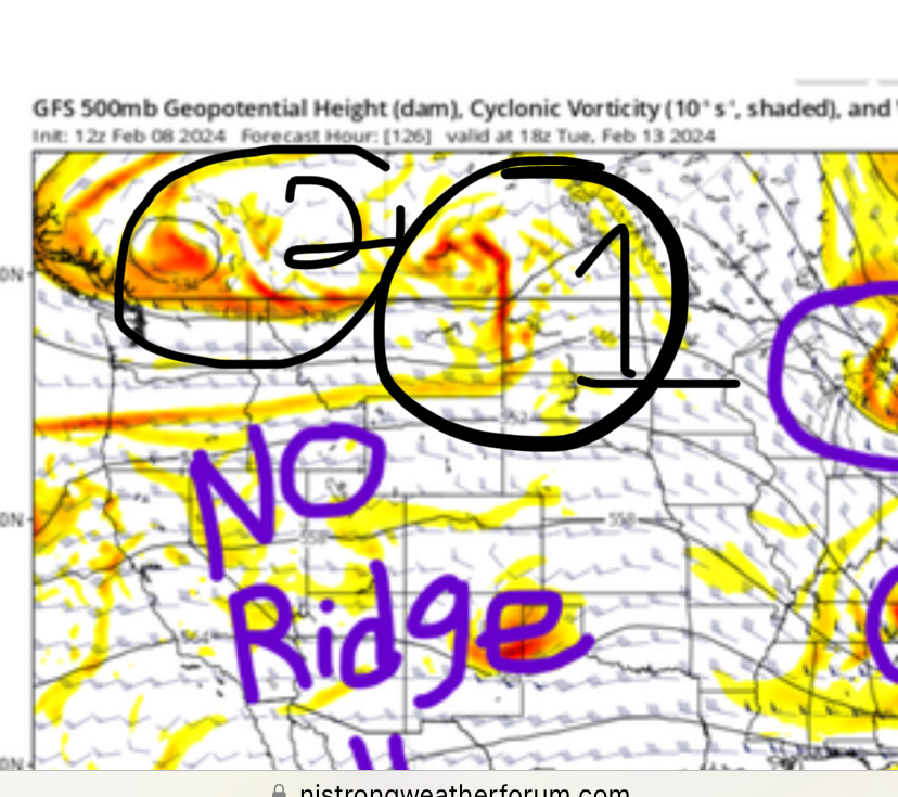
Hyde, I hate to say it, but I’m definitely seeing it the same way. Just my instinctive reactions to all of the analysis and modeling that has been posted, as well as the trend that has been in place basically all winter for the southern areas to be too warm. And the real trend that has been 100% inescapable the whole winter for the whole area: NO PHASE FOR YOU!!!!
Once that piece of trailing energy was detected as a threat to western CONUS ridge, it seems like that has been the dominant feature of the tracking. If I’m not mistaken, we actually two have TWO culprits knocking down the ridge.

So, I’ll be quite happy to be wrong (fortunately, I’m good at that!), but at the moment, I’m just not feeling so optimistic. But I am feeling appreciation and gratitude towards everyone on here who has been posting analysis and tracking and contributing. Last winter was far worse imo, there was basically zero threats to track, especially inside D4-5.
Once that piece of trailing energy was detected as a threat to western CONUS ridge, it seems like that has been the dominant feature of the tracking. If I’m not mistaken, we actually two have TWO culprits knocking down the ridge.

So, I’ll be quite happy to be wrong (fortunately, I’m good at that!), but at the moment, I’m just not feeling so optimistic. But I am feeling appreciation and gratitude towards everyone on here who has been posting analysis and tracking and contributing. Last winter was far worse imo, there was basically zero threats to track, especially inside D4-5.
SENJsnowman- Senior Enthusiast

- Posts : 1189
Reputation : 61
Join date : 2017-01-06
Age : 51
Location : Bayville, NJ
hyde345, essexcountypete and billg315 like this post
 Re: Long Range Thread 28.0
The exact path of the storm at the last minute may result in uncertainty as to the exact path. More information will be available 48 hrs after the storm has passed through. For further information about tracking, please go to www.usps.com to track its arrival time.

dkodgis- Senior Enthusiast

- Posts : 2618
Reputation : 98
Join date : 2013-12-29
kalleg, essexcountypete, SENJsnowman and Coachgriff like this post
 Re: Long Range Thread 28.0
docstox12 wrote:hyde345 wrote:billg315 wrote:12z Euro is a significant improvement from the 0z run. Brings the accumulating snow a good 50 miles south and gets much of North Jersey, NYC and LI in on at least some accumulation. Not anything to bank on yet, but if you had to say one model has moved toward the other, I guess it'd be fair to say the Euro is more moving toward the GFS -- or at least toward a solution in between where it and the GFS were 12 hours ago. But, many many more model runs to go in the coming days. NO MODEL HUGGING ALLOWED!! lol
The GFS is wrong and too cold. There is no way in hell that Southern NJ and the Delmarva are getting a snowstorm and NYC metro is on the northern fringe. I am riding a blend of the Euro/CMC for now.
Hyde, saw that happen in the 'Snowmageddon" year where a Buddy of mine in Atco NJ near Philly, got over 20 inches and my area in Mahwah NJ had "filtered" sun.Thinking a blend of GFS and EURO atm but way too early yet.NWS has me for snow to rain/snow to rain to rain/snow,LOL.How's that for covering all bets?
Yes, that has happened to me up here as well but with this particular setup and lack of cold air source I highly doubt what the GFS is trying to sell. We all know that when the GFS is an outlier it is often wrong and the other models seem to be a little more realistic IMO.

hyde345- Pro Enthusiast

- Posts : 1082
Reputation : 48
Join date : 2013-01-08
Location : Hyde Park, NY
 Re: Long Range Thread 28.0
SENJsnowman wrote:Hyde, I hate to say it, but I’m definitely seeing it the same way. Just my instinctive reactions to all of the analysis and modeling that has been posted, as well as the trend that has been in place basically all winter for the southern areas to be too warm. And the real trend that has been 100% inescapable the whole winter for the whole area: NO PHASE FOR YOU!!!!
Once that piece of trailing energy was detected as a threat to western CONUS ridge, it seems like that has been the dominant feature of the tracking. If I’m not mistaken, we actually two have TWO culprits knocking down the ridge.
So, I’ll be quite happy to be wrong (fortunately, I’m good at that!), but at the moment, I’m just not feeling so optimistic. But I am feeling appreciation and gratitude towards everyone on here who has been posting analysis and tracking and contributing. Last winter was far worse imo, there was basically zero threats to track, especially inside D4-5.
honestlyna ridge can be overcome. Frank only showed the CONUS view. There is still a stout ridge going up along the WC o Canada. This is too far south to call it pure -EPO and too far north to call it a pure +PNA. Even though the ridge along the immediate WC of the CONUS flattens there is still a hard presss of cold compliments of the WC Canada ridge and the 50/50 LP in the N Atlantic. There are a few finer details in between that need ironing out but this is still doable for sure.

_________________
"In weather and in life, there's no winning and losing; there's only winning and learning."
WINTER 2012/2013 TOTALS 43.65"WINTER 2017/2018 TOTALS 62.85" WINTER 2022/2023 TOTALS 4.9"
WINTER 2013/2014 TOTALS 64.85"WINTER 2018/2019 TOTALS 14.25" WINTER 2023/2024 TOTALS 13.1"
WINTER 2014/2015 TOTALS 71.20"WINTER 2019/2020 TOTALS 6.35"
WINTER 2015/2016 TOTALS 35.00"WINTER 2020/2021 TOTALS 37.75"
WINTER 2016/2017 TOTALS 42.25"WINTER 2021/2022 TOTALS 31.65"

sroc4- Admin

- Posts : 8389
Reputation : 302
Join date : 2013-01-07
Location : Wading River, LI
SENJsnowman likes this post
 Re: Long Range Thread 28.0
The trends to the ensembles have also been favorable. Last four EPS runs. Two things to pay attn to. First the Low locations cont to trends S. And second all images are valid for the same time stamp. The storm is trending slower. This slower trend, which is also trending on all op runs to, allows more time for the cold air to filter in.


_________________
"In weather and in life, there's no winning and losing; there's only winning and learning."
WINTER 2012/2013 TOTALS 43.65"WINTER 2017/2018 TOTALS 62.85" WINTER 2022/2023 TOTALS 4.9"
WINTER 2013/2014 TOTALS 64.85"WINTER 2018/2019 TOTALS 14.25" WINTER 2023/2024 TOTALS 13.1"
WINTER 2014/2015 TOTALS 71.20"WINTER 2019/2020 TOTALS 6.35"
WINTER 2015/2016 TOTALS 35.00"WINTER 2020/2021 TOTALS 37.75"
WINTER 2016/2017 TOTALS 42.25"WINTER 2021/2022 TOTALS 31.65"

sroc4- Admin

- Posts : 8389
Reputation : 302
Join date : 2013-01-07
Location : Wading River, LI
essexcountypete and jmanley32 like this post
 Re: Long Range Thread 28.0
Not much time for analysis. I looked at the 12Z EPS and there is more n/s trough linking to the Atlantic trough for h5 vorticity. It favors a southerly solution IMO. If this works the NAO will have done its work like I believe it will. IMO the only shot at BIG amounts are if that confluence forms coupled with a good injection of n/s energy. I'd put that on the lower end of possibilities for now. Not to say there is not a shot for substantial snowfall (3+) with this. Just all things must align for the > 6" IMO
heehaw453- Advanced Forecaster

- Posts : 3906
Reputation : 86
Join date : 2014-01-20
Location : Bedminster Township, PA Elevation 600' ASL
Page 8 of 18 •  1 ... 5 ... 7, 8, 9 ... 13 ... 18
Page 8 of 18
Permissions in this forum:
You cannot reply to topics in this forum|
|
|

 Home
Home

