Long Range Thread 8.0
+30
Grselig
devsman
chief7
oldtimer
Noreaster
Quietace
mako460
jimv45
rb924119
sroc4
HectorO
snow247
essexcountypete
chinkaps
billg315
Snow88
dkodgis
docstox12
WOLVES1
nutleyblizzard
CPcantmeasuresnow
algae888
skinsfan1177
Dunnzoo
weatherwatchermom
Math23x7
jmanley32
amugs
Dtone
Frank_Wx
34 posters
Page 13 of 40
Page 13 of 40 •  1 ... 8 ... 12, 13, 14 ... 26 ... 40
 Re: Long Range Thread 8.0
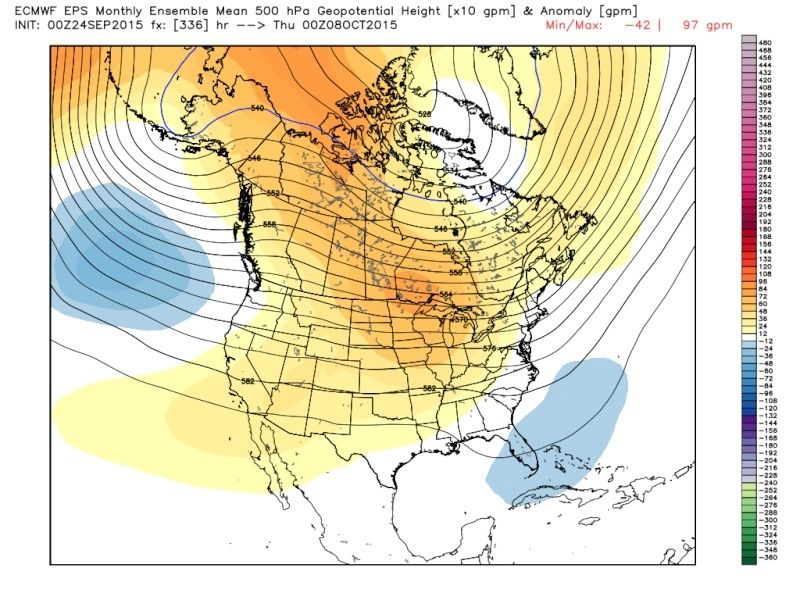
A second comment about the map I just posted: Take note of the trailing negative height anomalies that extend back through Texas. That's indicative of trailing energy that is rounding the ridge and still entering the base of the trough. In a "normal" year, that's nice to see.....in an El Nino year, that's REALLY NICE to see, especially if this was DJF.
rb924119- Meteorologist

- Posts : 7103
Join date : 2013-02-06
 Re: Long Range Thread 8.0
I know its in fantasy land but look at the storm track. that would be rain with temps in the 40's for early October. surface fits 500mb setup that rb posted above on euro...


algae888- Advanced Forecaster

- Posts : 5311
Join date : 2013-02-05
 Re: Long Range Thread 8.0
oh and first freeze for the year????

rb I agree with your comment on storm tracks in autumn usually carry over into winter.
nice to see lower heights in gulf. hopefully it will be open for business this year.

rb I agree with your comment on storm tracks in autumn usually carry over into winter.
nice to see lower heights in gulf. hopefully it will be open for business this year.

algae888- Advanced Forecaster

- Posts : 5311
Reputation : 46
Join date : 2013-02-05
Age : 62
Location : mt. vernon, new york
 Re: Long Range Thread 8.0
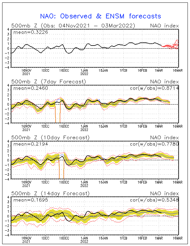
good sign that nao and ao have been mostly neg for four months now. hopefully this will continue into winter...


algae888- Advanced Forecaster

- Posts : 5311
Reputation : 46
Join date : 2013-02-05
Age : 62
Location : mt. vernon, new york
 Re: Long Range Thread 8.0
AAh sounds promising, the Euro is being pretty wish washy wow 00z now has a tropical or subtropical entity (992mb) developing off the carolinas and then moving into and inland into southern central jersey as a 50mph or so TS (highest pt nears cat 1 strength), far different than the 12z yesterday. Even the CMC doesnt show anything including the GFS, so is our pal the Euro sniffing something out well in advance which has done b4 ie. sandy or glue? LOL

jmanley32- Senior Enthusiast

- Posts : 20645
Reputation : 108
Join date : 2013-12-12
Age : 43
Location : Yonkers, NY
 Re: Long Range Thread 8.0
Bastardi saying its a hybrid system day 6-10 (verbatim, he is just seeing what we can all see), thats not all that far off for the earlier, def have watch that.

jmanley32- Senior Enthusiast

- Posts : 20645
Reputation : 108
Join date : 2013-12-12
Age : 43
Location : Yonkers, NY
 Re: Long Range Thread 8.0
Rb,
Great analysis of the set up you posted on the other page. I think most folks are crying foul about Nino saying "were is all the rain" that nino's are to bring. hey, it's like girlfriends - no two are alike!!!! Uptick in bathtub in region 1.2 and also regions 3 and 3.4 and the forcing looks to be moving west towards the dateline - let's hope the models are correct but it is a wait and see. A basin wide Nino at this point, let's look at this winter weenies as good.

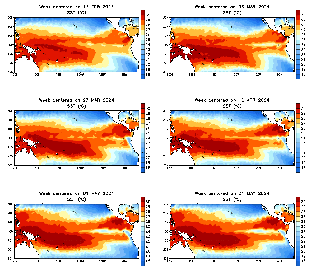
This is pretty warm waters that stretch for thousands of miles - pretty unprecedented.
Rb, I wholeheartedly agree in that how the set up takes shape in the fall is how the storm track most likely will occur come winter with slight variation. personally I would like to see this perturbation in teh atmosphere happen a tad later into October from past experiences - 1977, 1978, 1993, 2010 but I will take it.
Here is the update on my chia pet growth - excellent info here as we enter into the middle stage of this process.

9/24 JAXA Arctic Sea Ice Extent: 4,755,283 square kilometers. That was an increase of 50,922 square kilometers. Should Arctic sea ice extent increase at the 5-year average rate through 9/30.
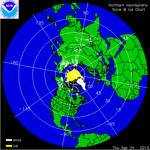
Here it is folks the snow/ice growth Chia Pet - in it pubescent stages - hahahah!
Beg in Sept:

Now - Sept 24 update

Great analysis of the set up you posted on the other page. I think most folks are crying foul about Nino saying "were is all the rain" that nino's are to bring. hey, it's like girlfriends - no two are alike!!!! Uptick in bathtub in region 1.2 and also regions 3 and 3.4 and the forcing looks to be moving west towards the dateline - let's hope the models are correct but it is a wait and see. A basin wide Nino at this point, let's look at this winter weenies as good.


This is pretty warm waters that stretch for thousands of miles - pretty unprecedented.
Rb, I wholeheartedly agree in that how the set up takes shape in the fall is how the storm track most likely will occur come winter with slight variation. personally I would like to see this perturbation in teh atmosphere happen a tad later into October from past experiences - 1977, 1978, 1993, 2010 but I will take it.
Here is the update on my chia pet growth - excellent info here as we enter into the middle stage of this process.

9/24 JAXA Arctic Sea Ice Extent: 4,755,283 square kilometers. That was an increase of 50,922 square kilometers. Should Arctic sea ice extent increase at the 5-year average rate through 9/30.

Here it is folks the snow/ice growth Chia Pet - in it pubescent stages - hahahah!
Beg in Sept:

Now - Sept 24 update

_________________
Mugs
AKA:King: Snow Weenie
Self Proclaimed
WINTER 2014-15 : 55.12" +.02 for 6 coatings (avg. 35")
WINTER 2015-16 Total - 29.8" (Avg 35")
WINTER 2016-17 : 39.5" so far

amugs- Advanced Forecaster - Mod

- Posts : 15148
Reputation : 213
Join date : 2013-01-07
Age : 54
Location : Hillsdale,NJ
 Re: Long Range Thread 8.0
Thanks Mugs! Can't stay on here too long atm, but I'm actually kind of amped to see the 12z EURO run for the extended.....just as a tease:
12z GFS day 12-13 timeframe:

I haven't been this excited since "The Great Depression of 2015" (when we were all supposed to get 3 feet lmao) In all seriousness, though, this image shows one of best looking setups that I might ever have seen at this point in the season. Whether or not it happens has yet to be determined, and I'm more than certain it will become the hot topic before too long haha
12z GFS day 12-13 timeframe:

I haven't been this excited since "The Great Depression of 2015" (when we were all supposed to get 3 feet lmao) In all seriousness, though, this image shows one of best looking setups that I might ever have seen at this point in the season. Whether or not it happens has yet to be determined, and I'm more than certain it will become the hot topic before too long haha
rb924119- Meteorologist

- Posts : 7103
Reputation : 195
Join date : 2013-02-06
Age : 32
Location : Greentown, Pa
 Re: Long Range Thread 8.0
rb924119 wrote:Thanks Mugs! Can't stay on here too long atm, but I'm actually kind of amped to see the 12z EURO run for the extended.....just as a tease:
12z GFS day 12-13 timeframe:
I haven't been this excited since "The Great Depression of 2015" (when we were all supposed to get 3 feet lmao) In all seriousness, though, this image shows one of best looking setups that I might ever have seen at this point in the season. Whether or not it happens has yet to be determined, and I'm more than certain it will become the hot topic before too long haha
That is a fantastic look at H5 - though would prefer to see a sharper trough - but that's semantics
@Mugs - those Chia Pet pics are hilarious.
_________________
_______________________________________________________________________________________________________
CLICK HERE to view NJ Strong Snowstorm Classifications
 Re: Long Range Thread 8.0
Pattern change incoming in 1.5 to 2 weeks...Frank_Wx wrote:rb924119 wrote:Thanks Mugs! Can't stay on here too long atm, but I'm actually kind of amped to see the 12z EURO run for the extended.....just as a tease:
12z GFS day 12-13 timeframe:
I haven't been this excited since "The Great Depression of 2015" (when we were all supposed to get 3 feet lmao) In all seriousness, though, this image shows one of best looking setups that I might ever have seen at this point in the season. Whether or not it happens has yet to be determined, and I'm more than certain it will become the hot topic before too long haha
That is a fantastic look at H5 - though would prefer to see a sharper trough - but that's semantics
@Mugs - those Chia Pet pics are hilarious.

Quietace- Meteorologist - Mod

- Posts : 3689
Reputation : 33
Join date : 2013-01-07
Age : 27
Location : Point Pleasant, NJ

Quietace- Meteorologist - Mod

- Posts : 3689
Reputation : 33
Join date : 2013-01-07
Age : 27
Location : Point Pleasant, NJ
 Re: Long Range Thread 8.0
Now is it to early to say where we will be at temperature wise in that timeframe

skinsfan1177- Senior Enthusiast

- Posts : 4485
Reputation : 35
Join date : 2013-01-07
Age : 47
Location : Point Pleasant Boro
 Re: Long Range Thread 8.0
skinsfan1177 wrote:Now is it to early to say where we will be at temperature wise in that timeframe
Probably in the 60's and 50's. Could see a lot of days in the 50's. But still too early to know for sure until we see the extent of the trough.
_________________
_______________________________________________________________________________________________________
CLICK HERE to view NJ Strong Snowstorm Classifications
 Re: Long Range Thread 8.0
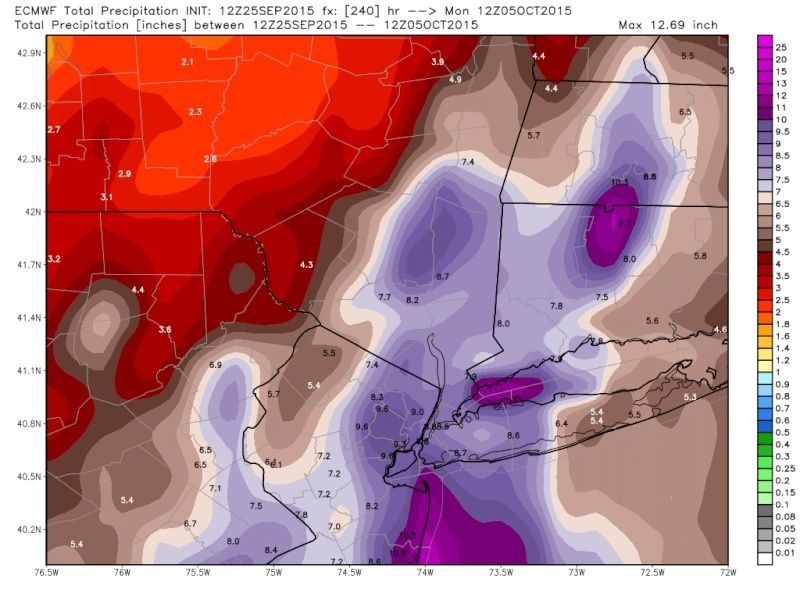
Dear lord, I do not think I have ever seen this for the area, day 7 and from there on nothing but deluge and two coastals, Frank are you concerned or is the Euro going CMC mode? CMC has far less which is rather funny.


jmanley32- Senior Enthusiast

- Posts : 20645
Reputation : 108
Join date : 2013-12-12
Age : 43
Location : Yonkers, NY
 Re: Long Range Thread 8.0
It basically rains and gale or higher winds verbatim from hours 156-228, WOW 

jmanley32- Senior Enthusiast

- Posts : 20645
Reputation : 108
Join date : 2013-12-12
Age : 43
Location : Yonkers, NY
 Re: Long Range Thread 8.0
jmanley32 wrote:Dear lord, I do not think I have ever seen this for the area, day 7 and from there on nothing but deluge and two coastals, Frank are you concerned or is the Euro going CMC mode? CMC has far less which is rather funny.
Well,that would be a drought buster for sure.These models sure get bizarre.

docstox12- Wx Statistician Guru

- Posts : 8611
Reputation : 222
Join date : 2013-01-07
Age : 74
Location : Monroe NY
 Re: Long Range Thread 8.0
Frank_Wx wrote:skinsfan1177 wrote:Now is it to early to say where we will be at temperature wise in that timeframe
Probably in the 60's and 50's. Could see a lot of days in the 50's. But still too early to know for sure until we see the extent of the trough.
Good! It's Fall and we need some 30's-50's temps around here to get in the swing of it.Still very warm for this time of year, during the day anyway up here.

docstox12- Wx Statistician Guru

- Posts : 8611
Reputation : 222
Join date : 2013-01-07
Age : 74
Location : Monroe NY
 Re: Long Range Thread 8.0
A obvious extreme run with no purpose of taking verbatim.

Quietace- Meteorologist - Mod

- Posts : 3689
Reputation : 33
Join date : 2013-01-07
Age : 27
Location : Point Pleasant, NJ
 Re: Long Range Thread 8.0
Yeah but still the Euro to go extreme at this time of year is not that usual is it? Yes I highly down we are going to see 8-12 inches of rain in a few days over this wide a area. Imagine if it was winter come on don't tell me you all wouldn't be seething lol

jmanley32- Senior Enthusiast

- Posts : 20645
Reputation : 108
Join date : 2013-12-12
Age : 43
Location : Yonkers, NY
 Re: Long Range Thread 8.0
All models have runs were a certain atmoshperic variable throws off convective elements and can cause issues. Its part of the nature of numerical modeling, and part of forecasting to acknowledge when it happens.jmanley32 wrote:Yeah but still the Euro to go extreme at this time of year is not that usual is it? Yes I highly down we are going to see 8-12 inches of rain in a few days over this wide a area. Imagine if it was winter come on don't tell me you all wouldn't be seething lol

Quietace- Meteorologist - Mod

- Posts : 3689
Reputation : 33
Join date : 2013-01-07
Age : 27
Location : Point Pleasant, NJ
 Re: Long Range Thread 8.0
GEFS also form a -EPO/trough over EC by end of run. Waiting for EPS to finish to see how they compare. Will be interesting to watch this time period for a flip.

Quietace- Meteorologist - Mod

- Posts : 3689
Reputation : 33
Join date : 2013-01-07
Age : 27
Location : Point Pleasant, NJ
 Re: Long Range Thread 8.0
Quietace wrote:GEFS also form a -EPO/trough over EC by end of run. Waiting for EPS to finish to see how they compare. Will be interesting to watch this time period for a flip.
At least from what I can tell at a quick glance, they look to be a wash by hour 200.....with 50 members this time of year and even stronger battles between signals than "normal", all 50 members are doing something vastly different. They average out to be a zonal flow with positive anomalies everywhere lol To demonstrate:

And that is only out to 240 haha by 360 you might as well be looking at a piece of abstract art lmfao
rb924119- Meteorologist

- Posts : 7103
Reputation : 195
Join date : 2013-02-06
Age : 32
Location : Greentown, Pa
 Re: Long Range Thread 8.0
That is very helpful being being able to see individual members on that data. Wxbell only gives standard deviation Anomalies for ensemble members, and only 2mT and precip for individual 51 EPS members all on separate graphs, which isn't helpful when comparing.rb924119 wrote:Quietace wrote:GEFS also form a -EPO/trough over EC by end of run. Waiting for EPS to finish to see how they compare. Will be interesting to watch this time period for a flip.
At least from what I can tell at a quick glance, they look to be a wash by hour 200.....with 50 members this time of year and even stronger battles between signals than "normal", all 50 members are doing something vastly different. They average out to be a zonal flow with positive anomalies everywhere lol To demonstrate:
And that is only out to 240 haha by 360 you might as well be looking at a piece of abstract art lmfao
This is my view @ 240 to compare.


Quietace- Meteorologist - Mod

- Posts : 3689
Reputation : 33
Join date : 2013-01-07
Age : 27
Location : Point Pleasant, NJ
 Re: Long Range Thread 8.0
rb924119 wrote:Quietace wrote:GEFS also form a -EPO/trough over EC by end of run. Waiting for EPS to finish to see how they compare. Will be interesting to watch this time period for a flip.
At least from what I can tell at a quick glance, they look to be a wash by hour 200.....with 50 members this time of year and even stronger battles between signals than "normal", all 50 members are doing something vastly different. They average out to be a zonal flow with positive anomalies everywhere lol To demonstrate:
And that is only out to 240 haha by 360 you might as well be looking at a piece of abstract art lmfao
Looks like my 5yr olds etch a sketch. Lol
_________________
"In weather and in life, there's no winning and losing; there's only winning and learning."
WINTER 2012/2013 TOTALS 43.65"WINTER 2017/2018 TOTALS 62.85" WINTER 2022/2023 TOTALS 4.9"
WINTER 2013/2014 TOTALS 64.85"WINTER 2018/2019 TOTALS 14.25" WINTER 2023/2024 TOTALS 13.1"
WINTER 2014/2015 TOTALS 71.20"WINTER 2019/2020 TOTALS 6.35" WINTER 2024/2025 TOTALS 0.00
WINTER 2015/2016 TOTALS 35.00"WINTER 2020/2021 TOTALS 37.75"
WINTER 2016/2017 TOTALS 42.25"WINTER 2021/2022 TOTALS 31.65"

sroc4- Admin

- Posts : 8458
Reputation : 302
Join date : 2013-01-07
Location : Wading River, LI
 Re: Long Range Thread 8.0
docstox12 wrote:jmanley32 wrote:Dear lord, I do not think I have ever seen this for the area, day 7 and from there on nothing but deluge and two coastals, Frank are you concerned or is the Euro going CMC mode? CMC has far less which is rather funny.
Well,that would be a drought buster for sure.These models sure get bizarre.
When looking at the long range trying to determine if a specific weather event is going to happen it is best to zoom out and focus on the big picture to determine if the pattern is conducive for such an event. Although a detailed map like this is a bit crazy to think will happen verbatim so far out and therefore is prob best left in the Banter thread, this weekend if I have the time I am going to try and show how something like this somewhere along the East Coast is actually not out of the realm of possibility in the long range (8-12day). If you all recall I did several "CASE STUDYS" last year in Jan showing what the LR looked like at 10-14days out; then how the models evolved as that time frame got closer. I am seeing some things in the LR as many have already mentioned above that have me intrigued. So for my first case study this season I am looking at the Oct 6th (+/- 24hrs) time frame. I am going to try and do a blog on it tomorrow morning.
_________________
"In weather and in life, there's no winning and losing; there's only winning and learning."
WINTER 2012/2013 TOTALS 43.65"WINTER 2017/2018 TOTALS 62.85" WINTER 2022/2023 TOTALS 4.9"
WINTER 2013/2014 TOTALS 64.85"WINTER 2018/2019 TOTALS 14.25" WINTER 2023/2024 TOTALS 13.1"
WINTER 2014/2015 TOTALS 71.20"WINTER 2019/2020 TOTALS 6.35" WINTER 2024/2025 TOTALS 0.00
WINTER 2015/2016 TOTALS 35.00"WINTER 2020/2021 TOTALS 37.75"
WINTER 2016/2017 TOTALS 42.25"WINTER 2021/2022 TOTALS 31.65"

sroc4- Admin

- Posts : 8458
Reputation : 302
Join date : 2013-01-07
Location : Wading River, LI
 Re: Long Range Thread 8.0
Frank, rb,Doc, Mugsy,Ace,J man, Al.....all great work and keep it coming! Enjoy reading all of it even though my low tech brain has trouble with it.I'm slowly learning.
Mention of a pattern change the next two weeks looks right.NWS has only low 60's for highs up here late next week.Hoping that clown map rainstorm above comes true to some extent as the reservoirs are dropping and my Fall trout fishing looks bad.Beaverkill River up in Roscoe NY dry as dust.
Mention of a pattern change the next two weeks looks right.NWS has only low 60's for highs up here late next week.Hoping that clown map rainstorm above comes true to some extent as the reservoirs are dropping and my Fall trout fishing looks bad.Beaverkill River up in Roscoe NY dry as dust.

docstox12- Wx Statistician Guru

- Posts : 8611
Reputation : 222
Join date : 2013-01-07
Age : 74
Location : Monroe NY
 Re: Long Range Thread 8.0
OHHHHH MAHHHHHH LORDDDDDDD


rb924119- Meteorologist

- Posts : 7103
Reputation : 195
Join date : 2013-02-06
Age : 32
Location : Greentown, Pa
Page 13 of 40 •  1 ... 8 ... 12, 13, 14 ... 26 ... 40
Page 13 of 40
Permissions in this forum:
You cannot reply to topics in this forum
 Home
Home