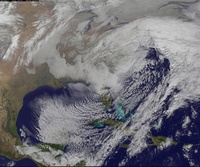
01/22/16 - 01/23/16 Update #3 - Will Models Trend Back North?
+54
static2987
Sparky Sparticles
H.G. Rising
lglickman1
deadrabbit79
Taffy
gigs68
Scullybutcher
crippo84
aiannone
Radz
hyde345
essexcountypete
Quietace
sroc4
billg315
SNOW MAN
Snowfall
Snow88
Sunflowers138
oldtimer
mako460
Dtone
Abba701
jake732
HEATMISER
WeatherBob
algae888
Artechmetals
Dis2cruise
Ferndue21
jimv45
CPcantmeasuresnow
Vinnydula
Joe Snow
justin92
chief7
weatherwatchermom
SoulSingMG
Math23x7
nutleyblizzard
pdubz
frank 638
skinsfan1177
jmanley32
NjWeatherGuy
devsman
Biggin23
amugs
RJB8525
snow247
WeatherJeff1224
rb924119
Frank_Wx
58 posters
Page 5 of 35
Page 5 of 35 •  1, 2, 3, 4, 5, 6 ... 20 ... 35
 Re: 01/22/16 - 01/23/16 Update #3 - Will Models Trend Back North?
The dgex was beyond epic for nj and hv nyc etc. Not try jinx anything here so just waiting on the gfs.
jmanley32- Senior Enthusiast

- Posts : 20648
Join date : 2013-12-12
 Re: 01/22/16 - 01/23/16 Update #3 - Will Models Trend Back North?
JB clinging to a DGEX map, I recall that situation not going well in 2010... We'll see what the GFS shows hopefully it comes back north and doesn't show as much of a confluence signal.
NjWeatherGuy- Advanced Forecaster

- Posts : 4100
Join date : 2013-01-06
 Re: 01/22/16 - 01/23/16 Update #3 - Will Models Trend Back North?
Hour 24 the PAC energy looks stronger.
_________________
_______________________________________________________________________________________________________
CLICK HERE to view NJ Strong Snowstorm Classifications
 Re: 01/22/16 - 01/23/16 Update #3 - Will Models Trend Back North?
Hour 30 trough looks stronger - and - the ULL in CA is slightly N&E. Slightly...
_________________
_______________________________________________________________________________________________________
CLICK HERE to view NJ Strong Snowstorm Classifications
 Re: 01/22/16 - 01/23/16 Update #3 - Will Models Trend Back North?
Shortwave in eastern Canada is definitely weaker here
rb924119- Meteorologist

- Posts : 7117
Reputation : 195
Join date : 2013-02-06
Age : 32
Location : Greentown, Pa
 Re: 01/22/16 - 01/23/16 Update #3 - Will Models Trend Back North?
Hour 36 the trough is actually pulled slightly west which is a good thing IMO. Will give heights ahead more time to rise. Also indicative of a slower evolution.
_________________
_______________________________________________________________________________________________________
CLICK HERE to view NJ Strong Snowstorm Classifications
chief7- Posts : 132
Reputation : 0
Join date : 2013-11-10
Location : Langhorne pa
 Re: 01/22/16 - 01/23/16 Update #3 - Will Models Trend Back North?
chief7 wrote:Is that good RB
Hopefully, assuming status quo with everything else.
rb924119- Meteorologist

- Posts : 7117
Reputation : 195
Join date : 2013-02-06
Age : 32
Location : Greentown, Pa
 Re: 01/22/16 - 01/23/16 Update #3 - Will Models Trend Back North?
Hour 45 I like it. Trough is stronger, ridge is stronger, now lets see if heights can respond along EC.
_________________
_______________________________________________________________________________________________________
CLICK HERE to view NJ Strong Snowstorm Classifications
 Re: 01/22/16 - 01/23/16 Update #3 - Will Models Trend Back North?
Frank_Wx wrote:Hour 45 I like it. Trough is stronger, ridge is stronger, now lets see if heights can respond along EC.
Looks like that pesky lobe of the PV is still there -_-
rb924119- Meteorologist

- Posts : 7117
Reputation : 195
Join date : 2013-02-06
Age : 32
Location : Greentown, Pa

Vinnydula- Pro Enthusiast

- Posts : 778
Reputation : 8
Join date : 2013-12-12
Location : Dobbs ferry
 Re: 01/22/16 - 01/23/16 Update #3 - Will Models Trend Back North?
Hour 57 the confluence over NW looks a tag stronger to me. More of a dip in heights. But the trough itself and heights over plains looks better.
_________________
_______________________________________________________________________________________________________
CLICK HERE to view NJ Strong Snowstorm Classifications
 Re: 01/22/16 - 01/23/16 Update #3 - Will Models Trend Back North?
NE not NW
_________________
_______________________________________________________________________________________________________
CLICK HERE to view NJ Strong Snowstorm Classifications
 Re: 01/22/16 - 01/23/16 Update #3 - Will Models Trend Back North?
Hour 63 - despite the confluence - heights rising into NJ now
_________________
_______________________________________________________________________________________________________
CLICK HERE to view NJ Strong Snowstorm Classifications
 Re: 01/22/16 - 01/23/16 Update #3 - Will Models Trend Back North?
Gonna be interesting how this second phase goes....
rb924119- Meteorologist

- Posts : 7117
Reputation : 195
Join date : 2013-02-06
Age : 32
Location : Greentown, Pa
 Re: 01/22/16 - 01/23/16 Update #3 - Will Models Trend Back North?
Hour 66 - trough is going neutral faster. 18z was still positive at this time. And that pesky s/w over NE is moving out faster.
_________________
_______________________________________________________________________________________________________
CLICK HERE to view NJ Strong Snowstorm Classifications
 Re: 01/22/16 - 01/23/16 Update #3 - Will Models Trend Back North?
Board is dead compared to last night.

skinsfan1177- Senior Enthusiast

- Posts : 4485
Reputation : 35
Join date : 2013-01-07
Age : 47
Location : Point Pleasant Boro
 Re: 01/22/16 - 01/23/16 Update #3 - Will Models Trend Back North?
Frank_Wx wrote:Hour 66 - trough is going neutral faster. 18z was still positive at this time. And that pesky s/w over NE is moving out faster.
Heights CLEARLY responding over the EC
rb924119- Meteorologist

- Posts : 7117
Reputation : 195
Join date : 2013-02-06
Age : 32
Location : Greentown, Pa
 Re: 01/22/16 - 01/23/16 Update #3 - Will Models Trend Back North?
low is over Tennessee and heights rising

pdubz- Pro Enthusiast

- Posts : 539
Reputation : 0
Join date : 2013-09-24
Age : 33
Location : Port Washington,NY (L.I)
 Re: 01/22/16 - 01/23/16 Update #3 - Will Models Trend Back North?
Heights are much higher along the EC. I THINK this should be better than 18z. But we'll see.
_________________
_______________________________________________________________________________________________________
CLICK HERE to view NJ Strong Snowstorm Classifications
 Re: 01/22/16 - 01/23/16 Update #3 - Will Models Trend Back North?
Energy coming into the Pacific Northwest is stronger compared to 12z, and ridge is folding a little faster.
Last edited by rb924119 on Tue Jan 19, 2016 10:54 pm; edited 1 time in total
rb924119- Meteorologist

- Posts : 7117
Reputation : 195
Join date : 2013-02-06
Age : 32
Location : Greentown, Pa
 Re: 01/22/16 - 01/23/16 Update #3 - Will Models Trend Back North?
Over hatteras at 81, come on, due north....

NjWeatherGuy- Advanced Forecaster

- Posts : 4100
Reputation : 28
Join date : 2013-01-06
Location : Belle Mead, NJ
 Re: 01/22/16 - 01/23/16 Update #3 - Will Models Trend Back North?

_________________
_______________________________________________________________________________________________________
CLICK HERE to view NJ Strong Snowstorm Classifications
 Re: 01/22/16 - 01/23/16 Update #3 - Will Models Trend Back North?
skinsfan1177 wrote:Board is dead compared to last night.
Not dead skins just nervous ass hell.

CPcantmeasuresnow- Wx Statistician Guru

- Posts : 7289
Reputation : 230
Join date : 2013-01-07
Age : 103
Location : Eastern Orange County, NY
 Re: 01/22/16 - 01/23/16 Update #3 - Will Models Trend Back North?
Wow


_________________
_______________________________________________________________________________________________________
CLICK HERE to view NJ Strong Snowstorm Classifications
 Re: 01/22/16 - 01/23/16 Update #3 - Will Models Trend Back North?
off the south Carolina shore now

pdubz- Pro Enthusiast

- Posts : 539
Reputation : 0
Join date : 2013-09-24
Age : 33
Location : Port Washington,NY (L.I)

NjWeatherGuy- Advanced Forecaster

- Posts : 4100
Reputation : 28
Join date : 2013-01-06
Location : Belle Mead, NJ
Page 5 of 35 •  1, 2, 3, 4, 5, 6 ... 20 ... 35
Page 5 of 35
Permissions in this forum:
You cannot reply to topics in this forum
 Home
Home