01/22/16 - 01/23/16 Update #3 - Will Models Trend Back North?
+54
static2987
Sparky Sparticles
H.G. Rising
lglickman1
deadrabbit79
Taffy
gigs68
Scullybutcher
crippo84
aiannone
Radz
hyde345
essexcountypete
Quietace
sroc4
billg315
SNOW MAN
Snowfall
Snow88
Sunflowers138
oldtimer
mako460
Dtone
Abba701
jake732
HEATMISER
WeatherBob
algae888
Artechmetals
Dis2cruise
Ferndue21
jimv45
CPcantmeasuresnow
Vinnydula
Joe Snow
justin92
chief7
weatherwatchermom
SoulSingMG
Math23x7
nutleyblizzard
pdubz
frank 638
skinsfan1177
jmanley32
NjWeatherGuy
devsman
Biggin23
amugs
RJB8525
snow247
WeatherJeff1224
rb924119
Frank_Wx
58 posters
Page 20 of 35
Page 20 of 35 •  1 ... 11 ... 19, 20, 21 ... 27 ... 35
 Re: 01/22/16 - 01/23/16 Update #3 - Will Models Trend Back North?
Jman we still need you for the precip and snowfall maps when you have them. You are the map and wind man.
CPcantmeasuresnow- Wx Statistician Guru

- Posts : 7289
Join date : 2013-01-07
 Re: 01/22/16 - 01/23/16 Update #3 - Will Models Trend Back North?
CPcantmeasuresnow wrote:Jman we still need you for the precip and snowfall maps when you have them. You are the map and wind man.
LOL okay.
jmanley32- Senior Enthusiast

- Posts : 20648
Join date : 2013-12-12
 Re: 01/22/16 - 01/23/16 Update #3 - Will Models Trend Back North?
I-95 corridor looks to be getting smashed this run....
rb924119- Meteorologist

- Posts : 7117
Reputation : 195
Join date : 2013-02-06
Age : 32
Location : Greentown, Pa
 Re: 01/22/16 - 01/23/16 Update #3 - Will Models Trend Back North?
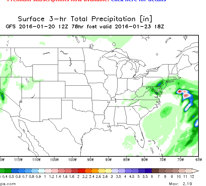
12z GFS


_________________
_______________________________________________________________________________________________________
CLICK HERE to view NJ Strong Snowstorm Classifications
 Re: 01/22/16 - 01/23/16 Update #3 - Will Models Trend Back North?
By Sat PM, low is offshore sub 990 and it's ripping along I-95...

SoulSingMG- Senior Enthusiast

- Posts : 2853
Reputation : 74
Join date : 2013-12-11
Location : Long Island City, NY
 Re: 01/22/16 - 01/23/16 Update #3 - Will Models Trend Back North?

_________________
_______________________________________________________________________________________________________
CLICK HERE to view NJ Strong Snowstorm Classifications
 Re: 01/22/16 - 01/23/16 Update #3 - Will Models Trend Back North?
Frank_Wx wrote:12z GFS
Holy snow.

SoulSingMG- Senior Enthusiast

- Posts : 2853
Reputation : 74
Join date : 2013-12-11
Location : Long Island City, NY
 Re: 01/22/16 - 01/23/16 Update #3 - Will Models Trend Back North?

_________________
_______________________________________________________________________________________________________
CLICK HERE to view NJ Strong Snowstorm Classifications
 Re: 01/22/16 - 01/23/16 Update #3 - Will Models Trend Back North?
Welp, im screwed up at Binghamton lol
_________________
-Alex Iannone-

aiannone- Senior Enthusiast - Mod

- Posts : 4828
Reputation : 92
Join date : 2013-01-07
Location : Saint James, LI (Northwest Suffolk Co.)
 Re: 01/22/16 - 01/23/16 Update #3 - Will Models Trend Back North?
A little south and east of 00z with H5 and weaker, but the corridor still does well
rb924119- Meteorologist

- Posts : 7117
Reputation : 195
Join date : 2013-02-06
Age : 32
Location : Greentown, Pa

aiannone- Senior Enthusiast - Mod

- Posts : 4828
Reputation : 92
Join date : 2013-01-07
Location : Saint James, LI (Northwest Suffolk Co.)
 Re: 01/22/16 - 01/23/16 Update #3 - Will Models Trend Back North?
There is some convective feedback. Models are seeing too much convection on the east side of the storm and the surface low is jumping to it. If the surface low stays closer to the coast instead of jumping, QPF total would be higher. So...I would not look at QPF on any model right now.
_________________
_______________________________________________________________________________________________________
CLICK HERE to view NJ Strong Snowstorm Classifications
 Re: 01/22/16 - 01/23/16 Update #3 - Will Models Trend Back North?
This is the first time in awhile we're getting a long duration event of almost 24 hours.


_________________
_______________________________________________________________________________________________________
CLICK HERE to view NJ Strong Snowstorm Classifications
 Re: 01/22/16 - 01/23/16 Update #3 - Will Models Trend Back North?
Yeah its quite a bit less snow than the 06z, hopefully ur right frank. Already looked but won't hug it.

jmanley32- Senior Enthusiast

- Posts : 20648
Reputation : 108
Join date : 2013-12-12
Age : 43
Location : Yonkers, NY
 Re: 01/22/16 - 01/23/16 Update #3 - Will Models Trend Back North?
Truly a DC special looks to be lining up. They've literally had days of runs with >2 ft.

SoulSingMG- Senior Enthusiast

- Posts : 2853
Reputation : 74
Join date : 2013-12-11
Location : Long Island City, NY
 Re: 01/22/16 - 01/23/16 Update #3 - Will Models Trend Back North?
Expect models to gradually uptick in QPF as we get closer. This is just the beginning! Wait until they recognize the jet dynamics and PVA within the trough itself. Going to be wild. Only thing that is important now is track!!
_________________
_______________________________________________________________________________________________________
CLICK HERE to view NJ Strong Snowstorm Classifications
 Re: 01/22/16 - 01/23/16 Update #3 - Will Models Trend Back North?
Frank_Wx wrote:Expect models to gradually uptick in QPF as we get closer. This is just the beginning! Wait until they recognize the jet dynamics and PVA within the trough itself. Going to be wild. Only thing that is important now is track!!
Did this track tick south and east at all? That's what I'm hearing...

SoulSingMG- Senior Enthusiast

- Posts : 2853
Reputation : 74
Join date : 2013-12-11
Location : Long Island City, NY
 Re: 01/22/16 - 01/23/16 Update #3 - Will Models Trend Back North?
Look at these precip rates east of the surface low. That is why some frames it literally "jumps" and looks very unrealistic. It is going where the convection is. In theory, this could be right but the surface low would not jump like that. It would be a gradual move east. So it cuts back on QPF amounts as a result.


_________________
_______________________________________________________________________________________________________
CLICK HERE to view NJ Strong Snowstorm Classifications
 Re: 01/22/16 - 01/23/16 Update #3 - Will Models Trend Back North?
Frank_Wx wrote:Expect models to gradually uptick in QPF as we get closer. This is just the beginning! Wait until they recognize the jet dynamics and PVA within the trough itself. Going to be wild. Only thing that is important now is track!!
Gonna take a nap under my desk like in Seinfeld to be able to be up for all the runs tonight lol

jmanley32- Senior Enthusiast

- Posts : 20648
Reputation : 108
Join date : 2013-12-12
Age : 43
Location : Yonkers, NY
 Re: 01/22/16 - 01/23/16 Update #3 - Will Models Trend Back North?
not that bad the good amounts on that map shoot into the lower hudson valley into conn
jimv45- Senior Enthusiast

- Posts : 1168
Reputation : 36
Join date : 2013-09-20
Location : Hopewell jct.
 Re: 01/22/16 - 01/23/16 Update #3 - Will Models Trend Back North?
Frank_Wx wrote:Look at these precip rates east of the surface low. That is why some frames it literally "jumps" and looks very unrealistic. It is going where the convection is. In theory, this could be right but the surface low would not jump like that. It would be a gradual move east. So it cuts back on QPF amounts as a result.
Yeah theres also a gap between parts of jersey and wescheter of several less inches of snow, I agree theres feedback issues, that doesn't make sense.

jmanley32- Senior Enthusiast

- Posts : 20648
Reputation : 108
Join date : 2013-12-12
Age : 43
Location : Yonkers, NY
 Re: 01/22/16 - 01/23/16 Update #3 - Will Models Trend Back North?
SoulSingMG wrote:Frank_Wx wrote:Expect models to gradually uptick in QPF as we get closer. This is just the beginning! Wait until they recognize the jet dynamics and PVA within the trough itself. Going to be wild. Only thing that is important now is track!!
Did this track tick south and east at all? That's what I'm hearing...
Yes, the H5 low did go south and east from 06z but not by a lot. Looks like models are still trying to "feel out" the confluence / ULL over SE CA.
_________________
_______________________________________________________________________________________________________
CLICK HERE to view NJ Strong Snowstorm Classifications
 Re: 01/22/16 - 01/23/16 Update #3 - Will Models Trend Back North?
A foot in the city or less?
Abba701- Posts : 328
Reputation : 0
Join date : 2013-01-14
 Re: 01/22/16 - 01/23/16 Update #3 - Will Models Trend Back North?
this is the final total map fwiw.


jmanley32- Senior Enthusiast

- Posts : 20648
Reputation : 108
Join date : 2013-12-12
Age : 43
Location : Yonkers, NY
 Re: 01/22/16 - 01/23/16 Update #3 - Will Models Trend Back North?
Frank_Wx wrote:SoulSingMG wrote:Frank_Wx wrote:Expect models to gradually uptick in QPF as we get closer. This is just the beginning! Wait until they recognize the jet dynamics and PVA within the trough itself. Going to be wild. Only thing that is important now is track!!
Did this track tick south and east at all? That's what I'm hearing...
Yes, the H5 low did go south and east from 06z but not by a lot. Looks like models are still trying to "feel out" the confluence / ULL over SE CA.
K, thanks. Other sources are saying what you are about the QPF, btw.

SoulSingMG- Senior Enthusiast

- Posts : 2853
Reputation : 74
Join date : 2013-12-11
Location : Long Island City, NY
 Re: 01/22/16 - 01/23/16 Update #3 - Will Models Trend Back North?
City and southern WC see 12-16. theres a strange gap as I mentioned in NE nj.

jmanley32- Senior Enthusiast

- Posts : 20648
Reputation : 108
Join date : 2013-12-12
Age : 43
Location : Yonkers, NY
 Re: 01/22/16 - 01/23/16 Update #3 - Will Models Trend Back North?
jmanley32 wrote:this is the final total map fwiw.
Lol, that's still 1-2 feet Nyc metro

SoulSingMG- Senior Enthusiast

- Posts : 2853
Reputation : 74
Join date : 2013-12-11
Location : Long Island City, NY
Page 20 of 35 •  1 ... 11 ... 19, 20, 21 ... 27 ... 35
Page 20 of 35
Permissions in this forum:
You cannot reply to topics in this forum
 Home
Home
