01/23/16 Storm Update #6 - Final Call
+38
SNOW MAN
dsvinos
Aerojet514
Sharon117
Taffy
2004blackwrx
Math23x7
mako460
SoulSingMG
Mathgod55
docstox12
amugs
lglickman1
dad4twoboys
crippo84
Fededle22
rb924119
GreyBeard
mmanisca
billg315
jtswife
skinsfan1177
Shannon1829
nujerzeedevil
nutleyblizzard
snow247
jimv45
weatherwatchermom
CPcantmeasuresnow
jwalsh
jmanley32
devsman
frank 638
RJB8525
down tines
sroc4
Grselig
Frank_Wx
42 posters
Page 8 of 9 •  1, 2, 3, 4, 5, 6, 7, 8, 9
 Re: 01/23/16 Storm Update #6 - Final Call
weatherwatchermom wrote:Nick Gregory just alluded to the nam without naming..they he is becoming worried and might have to up totals... does anyone know when winds supposed to start
I think the winds will gradually increase overnight, but strongest winds should start kicking up by mid-morning tomorrow.
billg315- Advanced Forecaster - Mod

- Posts : 4564
Join date : 2015-01-24
 Re: 01/23/16 Storm Update #6 - Final Call
Did it close off were you thought it would?rb924119 wrote:H5 closed off
weatherwatchermom- Senior Enthusiast

- Posts : 3897
Join date : 2014-11-25
 Re: 01/23/16 Storm Update #6 - Final Call
Frank, Sroc, or Ace, here's my second-call (note not Final Call, as I may change it again haha) so could you please add it to the maps thread when you have a second? Thanks!!!
Reason behind my numbers is that while the SREF mean has matched the evolution at H5 the best so far, I am not confident enough to extend the higher totals into the NYC metro and LI areas. Also, my 6-10" zone may be over-done with regard to it's northern extent, but I do think there will be enough areas that reach the low end of that range; this also goes for my 10-15" range across eastern PA, northern NJ, and the southern Hudson Valley, but again, I think there will be enough verifications in the 9-10" to at least justify my thinking. This may also not be my final call, as some of the latest guidance is suggesting that I should bring the 18-24" swath through northeastern NJ, NYC, and LI, as well as the 24-30" swath to where my my 18-24" zone currently is. That said, I think that would be much too high based on the guidance that I've looked at. We'll see.
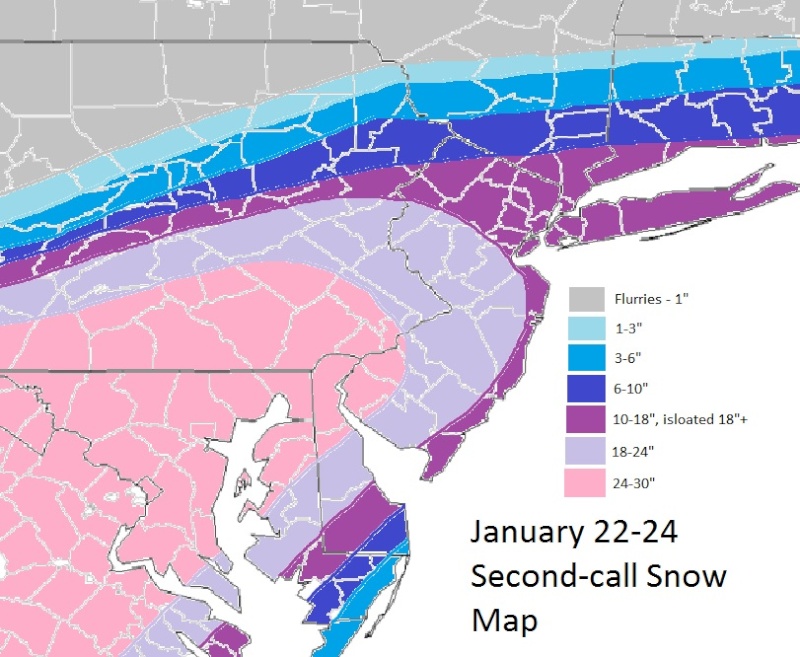
Reason behind my numbers is that while the SREF mean has matched the evolution at H5 the best so far, I am not confident enough to extend the higher totals into the NYC metro and LI areas. Also, my 6-10" zone may be over-done with regard to it's northern extent, but I do think there will be enough areas that reach the low end of that range; this also goes for my 10-15" range across eastern PA, northern NJ, and the southern Hudson Valley, but again, I think there will be enough verifications in the 9-10" to at least justify my thinking. This may also not be my final call, as some of the latest guidance is suggesting that I should bring the 18-24" swath through northeastern NJ, NYC, and LI, as well as the 24-30" swath to where my my 18-24" zone currently is. That said, I think that would be much too high based on the guidance that I've looked at. We'll see.

rb924119- Meteorologist

- Posts : 7117
Reputation : 195
Join date : 2013-02-06
Age : 32
Location : Greentown, Pa
 Re: 01/23/16 Storm Update #6 - Final Call
Nick Gregory on fox 5 just said he is very concerned. He was talking about the NAM being very persistent run after run along with the current observations. He said that he would be upping his snowfall totals but wanted to look at the GFS first.

nutleyblizzard- Senior Enthusiast

- Posts : 1964
Reputation : 42
Join date : 2014-01-30
Age : 58
Location : Nutley, new jersey
 Re: 01/23/16 Storm Update #6 - Final Call
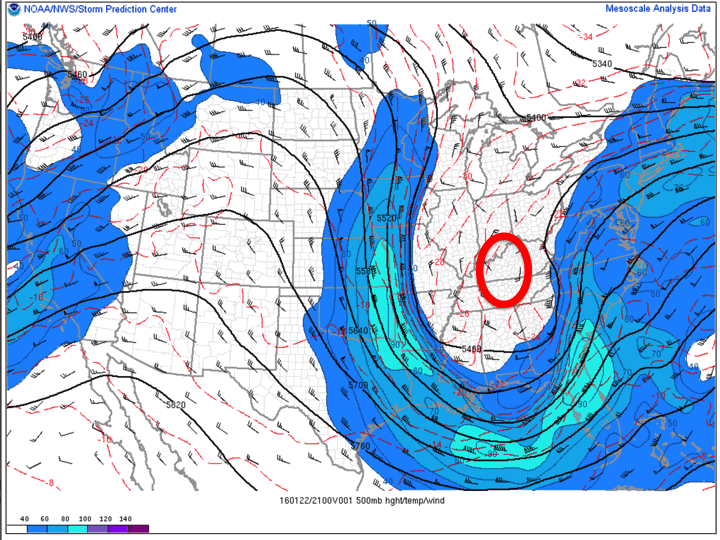
weatherwatchermom wrote:Did it close off were you thought it would?rb924119 wrote:H5 closed off
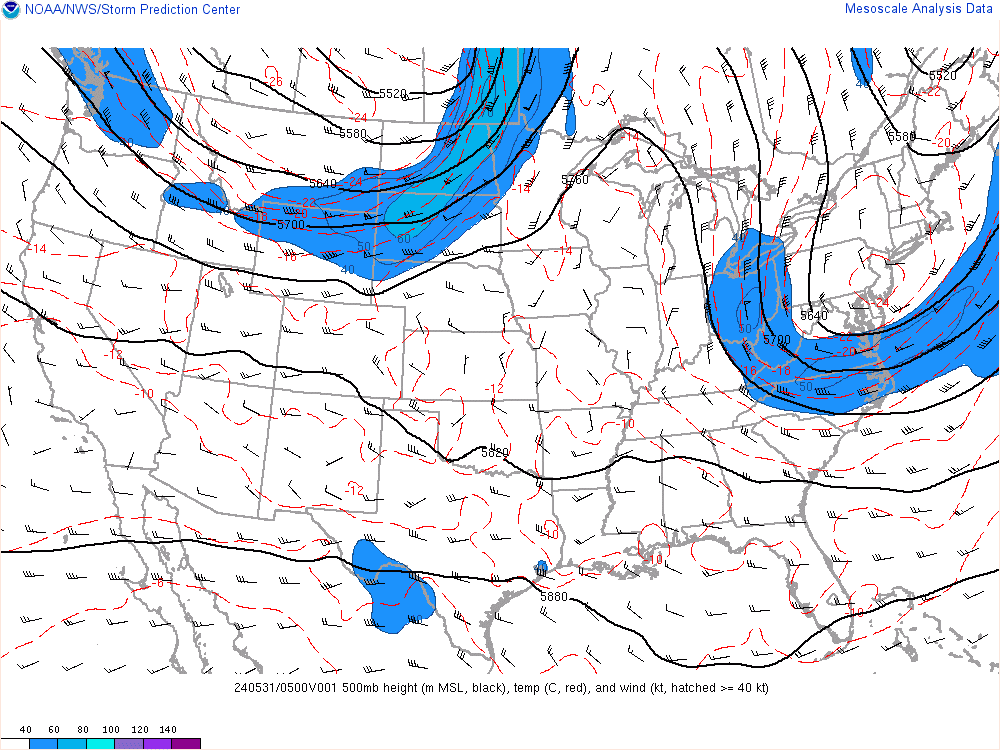
Well, it closed off a little later than I thought, and the contour (according to the Operational EMC RAP from the SPC Meso-scale Analysis) is a bit smaller, but otherwise, I think it's pretty damn close:
rb924119- Meteorologist

- Posts : 7117
Reputation : 195
Join date : 2013-02-06
Age : 32
Location : Greentown, Pa
 Re: 01/23/16 Storm Update #6 - Final Call
rb924119 wrote:Frank, Sroc, or Ace, here's my second-call (note not Final Call, as I may change it again haha) so could you please add it to the maps thread when you have a second? Thanks!!!
Reason behind my numbers is that while the SREF mean has matched the evolution at H5 the best so far, I am not confident enough to extend the higher totals into the NYC metro and LI areas. Also, my 6-10" zone may be over-done with regard to it's northern extent, but I do think there will be enough areas that reach the low end of that range; this also goes for my 10-15" range across eastern PA, northern NJ, and the southern Hudson Valley, but again, I think there will be enough verifications in the 9-10" to at least justify my thinking. This may also not be my final call, as some of the latest guidance is suggesting that I should bring the 18-24" swath through northeastern NJ, NYC, and LI, as well as the 24-30" swath to where my my 18-24" zone currently is. That said, I think that would be much too high based on the guidance that I've looked at. We'll see.
Rb I'm really liking your map for my area. Lets hope it happens.

SNOW MAN- Senior Enthusiast

- Posts : 1361
Reputation : 25
Join date : 2013-01-13
Age : 65
Location : Marshalls Creek Pa.
 Re: 01/23/16 Storm Update #6 - Final Call
NWS still with a watch for Orange County for max 6 inches of snow.
TWC just upped my forecast to 10-18 inches. At this point I have no clue as to what to expect here tomorrow. Those gradients are frightening in the HV as I've Harped about for days, they are similar to the blizzard of 96 only further south.
For those of us in the HV the 30 inches the NAM had us with 24 hours ago keeps slowly drifting south and is now in NNJ. This could go blizzard of 96 for parts of the HV, or Juno with the invisible barrier at the TZ bridge.
My biggest concern tomorrow is of course the Conservancy. They only had one minor measurement this year and they failed misreably coming in lower than any surrounding station. I hope they don't F up the big one. Could anything be worse than the zookeeper? Please God I hope not.
It should be very interesting and hopefully not aggravating nowcasting for everyone tomorrow. I'd love to see some records broken somewhere.
Good night all its been a long week.
CP

CPcantmeasuresnow- Wx Statistician Guru

- Posts : 7289
Reputation : 230
Join date : 2013-01-07
Age : 103
Location : Eastern Orange County, NY
 Re: 01/23/16 Storm Update #6 - Final Call
Nick Gregory and I are chatting now on Twitter; he's very concerned.


SoulSingMG- Senior Enthusiast

- Posts : 2853
Reputation : 74
Join date : 2013-12-11
Location : Long Island City, NY
 Re: 01/23/16 Storm Update #6 - Final Call
Currently in the process of updating my snow map. Wow.

snow247- Pro Enthusiast

- Posts : 2417
Reputation : 0
Join date : 2014-08-27
Location : Mount Ivy, NY - Elevation 545'
 Re: 01/23/16 Storm Update #6 - Final Call
This is so exciting I hope it delivers. Nws should make a big change at 1045. 15 min.

jmanley32- Senior Enthusiast

- Posts : 20648
Reputation : 108
Join date : 2013-12-12
Age : 43
Location : Yonkers, NY
 Re: 01/23/16 Storm Update #6 - Final Call
umm ya alot lolsnow247 wrote:Currently in the process of updating my snow map. Wow.

jmanley32- Senior Enthusiast

- Posts : 20648
Reputation : 108
Join date : 2013-12-12
Age : 43
Location : Yonkers, NY
 Re: 01/23/16 Storm Update #6 - Final Call
Gfs started I'm mobile right now.

jmanley32- Senior Enthusiast

- Posts : 20648
Reputation : 108
Join date : 2013-12-12
Age : 43
Location : Yonkers, NY
 Re: 01/23/16 Storm Update #6 - Final Call
RGEM!!!!!!!!!!!!!


algae888- Advanced Forecaster

- Posts : 5311
Reputation : 46
Join date : 2013-02-05
Age : 62
Location : mt. vernon, new york
 Re: 01/23/16 Storm Update #6 - Final Call
billg315 wrote:sroc4 wrote:billg315 wrote:Gentlemen. I think we're going to need a bigger shovel.
Jaws! I got it. Lol
Thanks. sometimes I wonder if my humor is out-dated. lol
Nope. This old man got the reference "Brody"

nujerzeedevil- Posts : 121
Reputation : 14
Join date : 2013-12-30
Location : Bayville, NJ
 Re: 01/23/16 Storm Update #6 - Final Call


forget the goofus nam lead the way WOW!!!!!

algae888- Advanced Forecaster

- Posts : 5311
Reputation : 46
Join date : 2013-02-05
Age : 62
Location : mt. vernon, new york
 Re: 01/23/16 Storm Update #6 - Final Call
jackpot al!algae888 wrote:RGEM!!!!!!!!!!!!!

jmanley32- Senior Enthusiast

- Posts : 20648
Reputation : 108
Join date : 2013-12-12
Age : 43
Location : Yonkers, NY
 Re: 01/23/16 Storm Update #6 - Final Call
GFS is WAY north
rb924119- Meteorologist

- Posts : 7117
Reputation : 195
Join date : 2013-02-06
Age : 32
Location : Greentown, Pa
 Re: 01/23/16 Storm Update #6 - Final Call
YESSSS!!!! jman we jackpot!!! give me the rgem any day inside 24hrs but kudos to the NAM!!!!jmanley32 wrote:jackpot al!algae888 wrote:RGEM!!!!!!!!!!!!!
Last edited by algae888 on Fri Jan 22, 2016 10:36 pm; edited 1 time in total

algae888- Advanced Forecaster

- Posts : 5311
Reputation : 46
Join date : 2013-02-05
Age : 62
Location : mt. vernon, new york
 Re: 01/23/16 Storm Update #6 - Final Call
The drifts are going to b nuts some doorways nay not b open able.

jmanley32- Senior Enthusiast

- Posts : 20648
Reputation : 108
Join date : 2013-12-12
Age : 43
Location : Yonkers, NY
 Re: 01/23/16 Storm Update #6 - Final Call
2 ft more realistic.algae888 wrote:YESSSS!!!! jman we jackpot!!! give me the rgem any day inside 48hrs but kudos to the NAM!!!!jmanley32 wrote:jackpot al!algae888 wrote:RGEM!!!!!!!!!!!!!

jmanley32- Senior Enthusiast

- Posts : 20648
Reputation : 108
Join date : 2013-12-12
Age : 43
Location : Yonkers, NY
 Re: 01/23/16 Storm Update #6 - Final Call
These two threat are driving me nuts can't we just have one

Vinnydula- Pro Enthusiast

- Posts : 778
Reputation : 8
Join date : 2013-12-12
Location : Dobbs ferry
 Re: 01/23/16 Storm Update #6 - Final Call
Jman anything near you yet?

Vinnydula- Pro Enthusiast

- Posts : 778
Reputation : 8
Join date : 2013-12-12
Location : Dobbs ferry
 Re: 01/23/16 Storm Update #6 - Final Call
Let me go look.

jmanley32- Senior Enthusiast

- Posts : 20648
Reputation : 108
Join date : 2013-12-12
Age : 43
Location : Yonkers, NY
 Re: 01/23/16 Storm Update #6 - Final Call
rb924119 wrote:GFS is WAY north
Will you be updating your snow fall map again ?

SNOW MAN- Senior Enthusiast

- Posts : 1361
Reputation : 25
Join date : 2013-01-13
Age : 65
Location : Marshalls Creek Pa.
 Re: 01/23/16 Storm Update #6 - Final Call
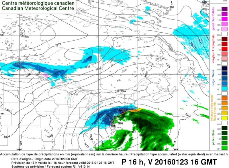
Hour 16 of the 0Z RGEM!!!! As Frank would say: MADONNE! ROIDZILLA INCOMING!!!!

Math23x7- Wx Statistician Guru

- Posts : 2382
Reputation : 68
Join date : 2013-01-08

jmanley32- Senior Enthusiast

- Posts : 20648
Reputation : 108
Join date : 2013-12-12
Age : 43
Location : Yonkers, NY
 Re: 01/23/16 Storm Update #6 - Final Call
SNOW MAN wrote:rb924119 wrote:GFS is WAY north
Will you be updating your snow fall map again ?
Sorry not sorry yes ahaha
rb924119- Meteorologist

- Posts : 7117
Reputation : 195
Join date : 2013-02-06
Age : 32
Location : Greentown, Pa
Page 8 of 9 •  1, 2, 3, 4, 5, 6, 7, 8, 9
Permissions in this forum:
You cannot reply to topics in this forum
 Home
Home