Long Range Thread 16.0
+44
snowday111
HectorO
Grselig
essexcountypete
Snow88
mwilli5783
WeatherBob
NjWeatherGuy
Dunnzoo
jake732
aiannone
crippo84
bobjohnsonforthehall
Scullybutcher
algae888
dsix85
dkodgis
sroc4
emokid51783
Math23x7
Sanchize06
docstox12
billg315
oldtimer
CPcantmeasuresnow
skinsfan1177
Quietace
SENJsnowman
lglickman1
hyde345
MattyICE
Carter bk
RJB8525
jimv45
amugs
GreyBeard
weatherwatchermom
SoulSingMG
nutleyblizzard
mikeypizano
rb924119
frank 638
jmanley32
Frank_Wx
48 posters
Page 25 of 40
Page 25 of 40 •  1 ... 14 ... 24, 25, 26 ... 32 ... 40
 Re: Long Range Thread 16.0
You know, CP, I'm almost wondering why this system for this weekend couldn't slide in under and behind the western Atlantic ridge and give the NW folks a surprise wintry or even snow event. It doesn't look likely at face value on current guidance, but I would almost argue that we will see a harder south and east trend with it within the next 72 hours. This is certainly an interesting case, but one in which I would say there is a substantial chance for something wintry. I'm gonna watch this carefully, and evaluate further.
rb924119- Meteorologist

- Posts : 7107
Join date : 2013-02-06
 Re: Long Range Thread 16.0
Frank_Wx wrote:Prime cutter pattern
Yeah it looks to want to shoot the gap right over our area. However, that HP in the north is fairly strong. Despite the consistency so far, it wouldn't surpsise me for it to trend a bit further south, which may be prevented from going too far due to the Atlantic high. I could see a track nearly over or just south of the NYC area, getting our northernmost members into some nasty icing possibility. However, I can also see it hold serve and track just to the north of the area. Not overly concerned about this for my area, but areas that got significantly more snow to the east and northeast should watch for flooding potential. Snowpack will be quickly melted from the next few days and this storm.
NjWeatherGuy- Advanced Forecaster

- Posts : 4100
Join date : 2013-01-06

aiannone- Senior Enthusiast - Mod

- Posts : 4827
Reputation : 92
Join date : 2013-01-07
Location : Saint James, LI (Northwest Suffolk Co.)
 Re: Long Range Thread 16.0
aiannone wrote:12z EURO: hmmm..... lol
Looking like an mix/ice threat there verbatim no?
crippo84- Posts : 383
Reputation : 20
Join date : 2013-11-07
Age : 40
Location : East Village, NYC
 Re: Long Range Thread 16.0
Man what a difference a week makes. Last week at this time the place was jumpin' with excitement anticipating a nice storm. Too bad the weekend looks wet not white. Is there nothing on the horizon? Looks like a warmup for the weekend and getting colder as we start next week with a hint of some white stuff tues./wed.
GreyBeard- Senior Enthusiast

- Posts : 732
Reputation : 34
Join date : 2014-02-12
Location : Boca Raton, Fl.
 Re: Long Range Thread 16.0
OH SNAP PEEPS DEEP THUNDER NOT BUDGIN here - compliments of neighbor Superstorm 93
SE periphery is ice on DT

ICE ICE BABY!!

.png.19962a8bb509699c2efa78189b568231.png)
SE periphery is ice on DT

ICE ICE BABY!!

.png.19962a8bb509699c2efa78189b568231.png)
_________________
Mugs
AKA:King: Snow Weenie
Self Proclaimed
WINTER 2014-15 : 55.12" +.02 for 6 coatings (avg. 35")
WINTER 2015-16 Total - 29.8" (Avg 35")
WINTER 2016-17 : 39.5" so far

amugs- Advanced Forecaster - Mod

- Posts : 15149
Reputation : 213
Join date : 2013-01-07
Age : 54
Location : Hillsdale,NJ
 Re: Long Range Thread 16.0
EPS for Tuesday WOWZA!!!


_________________
Mugs
AKA:King: Snow Weenie
Self Proclaimed
WINTER 2014-15 : 55.12" +.02 for 6 coatings (avg. 35")
WINTER 2015-16 Total - 29.8" (Avg 35")
WINTER 2016-17 : 39.5" so far

amugs- Advanced Forecaster - Mod

- Posts : 15149
Reputation : 213
Join date : 2013-01-07
Age : 54
Location : Hillsdale,NJ
 Re: Long Range Thread 16.0
With all due respect mugs, Deep Thunder has been around for over 20 yrs. If it was that good I think we would have heard more about it a long time ago.
https://en.wikipedia.org/wiki/IBM_Deep_Thunder
It's still experimental.
Even that article says it needs to be updated. You can keep the ice, I'd rather have rain.
https://en.wikipedia.org/wiki/IBM_Deep_Thunder
It's still experimental.
Even that article says it needs to be updated. You can keep the ice, I'd rather have rain.
GreyBeard- Senior Enthusiast

- Posts : 732
Reputation : 34
Join date : 2014-02-12
Location : Boca Raton, Fl.
 Re: Long Range Thread 16.0
GreyBeard wrote:With all due respect mugs, Deep Thunder has been around for over 20 yrs. If it was that good I think we would have heard more about it a long time ago.
https://en.wikipedia.org/wiki/IBM_Deep_Thunder
It's still experimental.
Even that article says it needs to be updated. You can keep the ice, I'd rather have rain.
Although its been around for years its recent upgrades have brought it back to the forefront of discussion. Weekends storm is def getting interesting for N&W folks. Its all dependent on the Northern kicker. Its trended faster and stronger on the euro. The energy that is steering the system for the weekend is in part way up north in the frozen tundra of Canada and the arctic and a piece of it is still over the Pac. 12z runs tomorrow will be interesting. Its close to winter weather for N&W peeps. Not a blockbuster but wintry conditions with some accum possible.
Last edited by sroc4 on Wed Jan 10, 2018 6:21 pm; edited 1 time in total
_________________
"In weather and in life, there's no winning and losing; there's only winning and learning."
WINTER 2012/2013 TOTALS 43.65"WINTER 2017/2018 TOTALS 62.85" WINTER 2022/2023 TOTALS 4.9"
WINTER 2013/2014 TOTALS 64.85"WINTER 2018/2019 TOTALS 14.25" WINTER 2023/2024 TOTALS 13.1"
WINTER 2014/2015 TOTALS 71.20"WINTER 2019/2020 TOTALS 6.35" WINTER 2024/2025 TOTALS 0.00
WINTER 2015/2016 TOTALS 35.00"WINTER 2020/2021 TOTALS 37.75"
WINTER 2016/2017 TOTALS 42.25"WINTER 2021/2022 TOTALS 31.65"

sroc4- Admin

- Posts : 8458
Reputation : 302
Join date : 2013-01-07
Location : Wading River, LI
 Re: Long Range Thread 16.0
GreyBeard wrote:With all due respect mugs, Deep Thunder has been around for over 20 yrs. If it was that good I think we would have heard more about it a long time ago.
https://en.wikipedia.org/wiki/IBM_Deep_Thunder
It's still experimental.
Even that article says it needs to be updated. You can keep the ice, I'd rather have rain.
Really did not know this - WSI has been using this as a new model the past 8 months.
Listen I dont make the weather just interpreter maps to teh best of my ability here.
Weak Nina patterns bring ice so it isn't he first not the last time we will see such.
_________________
Mugs
AKA:King: Snow Weenie
Self Proclaimed
WINTER 2014-15 : 55.12" +.02 for 6 coatings (avg. 35")
WINTER 2015-16 Total - 29.8" (Avg 35")
WINTER 2016-17 : 39.5" so far

amugs- Advanced Forecaster - Mod

- Posts : 15149
Reputation : 213
Join date : 2013-01-07
Age : 54
Location : Hillsdale,NJ
 Re: Long Range Thread 16.0
amugs wrote:EPS for Tuesday WOWZA!!!
mugs what does this map mean?

weatherwatchermom- Senior Enthusiast

- Posts : 3894
Reputation : 78
Join date : 2014-11-25
Location : Hazlet Township, NJ
 Re: Long Range Thread 16.0
Really did not know this - WSI has been using this as a new model the past 8 months.
Listen I dont make the weather just interpreter maps to teh best of my ability here.
Weak Nina patterns bring ice so it isn't he first not the last time we will see such.[/quote]
And your enthusiasm is noted and appreciated. I just did a little digging as you seem to be referencing Deep Thunder quite often recently. Hey, the more tools in the toolbox the better off you are, right?
@sroc,appreciate your explanation too. Hope the N&W guys and gals get the goods, they are long overdue.
GreyBeard- Senior Enthusiast

- Posts : 732
Reputation : 34
Join date : 2014-02-12
Location : Boca Raton, Fl.
 Re: Long Range Thread 16.0
Starting to get very interesting for a Friday night Saturday morning specially for Northwest areas. Look at the temperature contrast on all the models single digits in Upstate New York and interior New England and in the 50s in the city. The trend has been no phase of the two systems so the southern system is now weaker which should allow the cold air to drain in to the south and east. how far remains to be seen But as Scott says still have another 24 hours to get the right sampling. But that is some brutal cold coming in after the storm could be in the single digits again Sunday morning

algae888- Advanced Forecaster

- Posts : 5311
Reputation : 46
Join date : 2013-02-06
Age : 62
Location : mt. vernon, new york
 Re: Long Range Thread 16.0
Wait I thought the temps were going to continue to rise now back to single digits onsun? No thaw? Verbatim I see a major ice storm threat that keeps shifting south. Also seeing a period of high winds, do they always verify NO BUT as with the blizzard frank was surprised it was as windy as it was...I still got no props for getting that right lol

jmanley32- Senior Enthusiast

- Posts : 20645
Reputation : 108
Join date : 2013-12-13
Age : 43
Location : Yonkers, NY
 Re: Long Range Thread 16.0
EPS NICE SHIFT EAST!!
ALEX I'LL TAKE THE L OFF THE DEL MAR VA FOR 1000!!
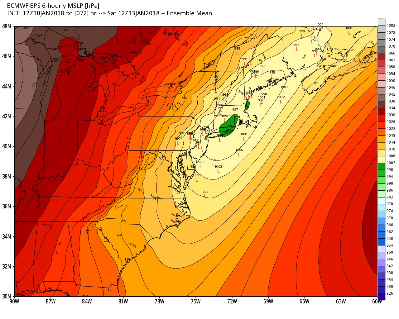
Cp and Doc and Damian now uknow why I was excited the other night. I smell the cold press. With all of this low level arctic ait sitting to our north all it takes is a slight atmospheric adjustment and the flood gates or cold gates open this year unlike the past two.
Also CFSV2 forecasting along with GFS a perturbation of the Polar Vortex that could.lead to another bought, round of arctic intrusion comes through in February.
ALEX I'LL TAKE THE L OFF THE DEL MAR VA FOR 1000!!

Cp and Doc and Damian now uknow why I was excited the other night. I smell the cold press. With all of this low level arctic ait sitting to our north all it takes is a slight atmospheric adjustment and the flood gates or cold gates open this year unlike the past two.
Also CFSV2 forecasting along with GFS a perturbation of the Polar Vortex that could.lead to another bought, round of arctic intrusion comes through in February.
Last edited by amugs on Wed Jan 10, 2018 7:22 pm; edited 1 time in total
_________________
Mugs
AKA:King: Snow Weenie
Self Proclaimed
WINTER 2014-15 : 55.12" +.02 for 6 coatings (avg. 35")
WINTER 2015-16 Total - 29.8" (Avg 35")
WINTER 2016-17 : 39.5" so far

amugs- Advanced Forecaster - Mod

- Posts : 15149
Reputation : 213
Join date : 2013-01-07
Age : 54
Location : Hillsdale,NJ
 Re: Long Range Thread 16.0
weatherwatchermom wrote:Mom it shows a coastal low that would bring us a plow able snowstorm if it verifies. Tuesdayish is the time frameamugs wrote:EPS for Tuesday WOWZA!!!
mugs what does this map mean?
_________________
Mugs
AKA:King: Snow Weenie
Self Proclaimed
WINTER 2014-15 : 55.12" +.02 for 6 coatings (avg. 35")
WINTER 2015-16 Total - 29.8" (Avg 35")
WINTER 2016-17 : 39.5" so far

amugs- Advanced Forecaster - Mod

- Posts : 15149
Reputation : 213
Join date : 2013-01-07
Age : 54
Location : Hillsdale,NJ
 Re: Long Range Thread 16.0
that's a serious ice storm.amugs wrote:OH SNAP PEEPS DEEP THUNDER NOT BUDGIN here - compliments of neighbor Superstorm 93
SE periphery is ice on DT
ICE ICE BABY!!

jmanley32- Senior Enthusiast

- Posts : 20645
Reputation : 108
Join date : 2013-12-13
Age : 43
Location : Yonkers, NY
 Re: Long Range Thread 16.0
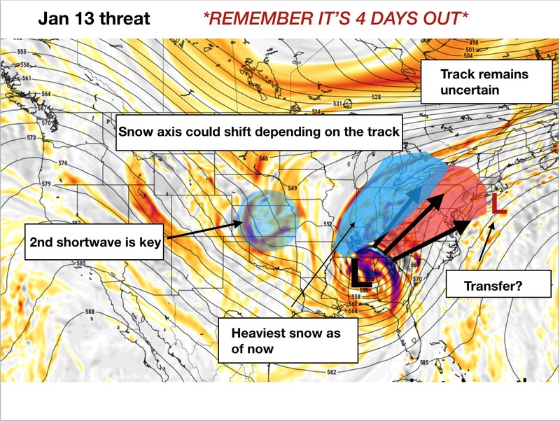
Off twitree

_________________
Mugs
AKA:King: Snow Weenie
Self Proclaimed
WINTER 2014-15 : 55.12" +.02 for 6 coatings (avg. 35")
WINTER 2015-16 Total - 29.8" (Avg 35")
WINTER 2016-17 : 39.5" so far

amugs- Advanced Forecaster - Mod

- Posts : 15149
Reputation : 213
Join date : 2013-01-07
Age : 54
Location : Hillsdale,NJ
 Re: Long Range Thread 16.0
Mugs, I see your point. I am starting to get a whiff of it, too.

dkodgis- Senior Enthusiast

- Posts : 2691
Reputation : 98
Join date : 2013-12-29
 Re: Long Range Thread 16.0
0z Nam is coming in more south

Snow88- Senior Enthusiast

- Posts : 2193
Reputation : 4
Join date : 2013-01-09
Age : 36
Location : Brooklyn, NY
 Re: Long Range Thread 16.0
18z Deep Thunder


Snow88- Senior Enthusiast

- Posts : 2193
Reputation : 4
Join date : 2013-01-09
Age : 36
Location : Brooklyn, NY
 Re: Long Range Thread 16.0
Setup always looked this possibility existed but early in the week no models seemed to want to make the leap of faith. If this keeps trending positive the N & W could be very nasty Friday night and Saturday morning. The rest of tonight and tomorrow’s 12Z will have my interest. Would like to see what the shorter range models say tomorrow too.
I like the colder trend but at the same time I could so without an ice storm. Hate the stuff.
A sleet storm like we had a couple of years ago I’ll take. The 3-4 inches of sleet stayed around for weeks.
I like the colder trend but at the same time I could so without an ice storm. Hate the stuff.
A sleet storm like we had a couple of years ago I’ll take. The 3-4 inches of sleet stayed around for weeks.

CPcantmeasuresnow- Wx Statistician Guru

- Posts : 7284
Reputation : 230
Join date : 2013-01-08
Age : 103
Location : Eastern Orange County, NY
 Re: Long Range Thread 16.0
CPcantmeasuresnow wrote:Setup always looked this possibility existed but early in the week no models seemed to want to make the leap of faith. If this keeps trending positive the N & W could be very nasty Friday night and Saturday morning. The rest of tonight and tomorrow’s 12Z will have my interest. Would like to see what the shorter range models say tomorrow too.
I like the colder trend but at the same time I could so without an ice storm. Hate the stuff.
A sleet storm like we had a couple of years ago I’ll take. The 3-4 inches of sleet stayed around for weeks.
Yea, but it was an absolute bitch to shovel.

hyde345- Pro Enthusiast

- Posts : 1083
Reputation : 48
Join date : 2013-01-08
Location : Hyde Park, NY
 Re: Long Range Thread 16.0
hyde345 wrote:CPcantmeasuresnow wrote:Setup always looked this possibility existed but early in the week no models seemed to want to make the leap of faith. If this keeps trending positive the N & W could be very nasty Friday night and Saturday morning. The rest of tonight and tomorrow’s 12Z will have my interest. Would like to see what the shorter range models say tomorrow too.
I like the colder trend but at the same time I could so without an ice storm. Hate the stuff.
A sleet storm like we had a couple of years ago I’ll take. The 3-4 inches of sleet stayed around for weeks.
Yea, but it was an absolute bitch to shovel.
Yeah Hyde it was tough. The snow blower would not handle it. Four inches of that felt like the weight of 20 inches of snow. But the water content and density made it seem impervious to sun.

CPcantmeasuresnow- Wx Statistician Guru

- Posts : 7284
Reputation : 230
Join date : 2013-01-08
Age : 103
Location : Eastern Orange County, NY
 Re: Long Range Thread 16.0
Well it's our resident experts VS the NWS as they have no mention at all of any frozen precip Friday night into Saturday morning.I love these scenarios.Anyhoo, hope some of the snowpack survives the major assault about to come.

docstox12- Wx Statistician Guru

- Posts : 8613
Reputation : 222
Join date : 2013-01-07
Age : 74
Location : Monroe NY
 Re: Long Range Thread 16.0
Guess no one saw the 00z euro snow map into next week huh love those clown maps but they are fun to look at. Only benefits our nw folks msinly have not seen the storm.that causes this output but if ur around Albany north prepare for 60 inches lol

jmanley32- Senior Enthusiast

- Posts : 20645
Reputation : 108
Join date : 2013-12-13
Age : 43
Location : Yonkers, NY
 Re: Long Range Thread 16.0
Put out an update on the weekend storm in the January thread.
I do see the snowstorm threat showing up on guidance for the middle of next week. We'll keep an eye on it. Interesting evolution.
I do see the snowstorm threat showing up on guidance for the middle of next week. We'll keep an eye on it. Interesting evolution.
_________________
_______________________________________________________________________________________________________
CLICK HERE to view NJ Strong Snowstorm Classifications
Page 25 of 40 •  1 ... 14 ... 24, 25, 26 ... 32 ... 40
Page 25 of 40
Permissions in this forum:
You cannot reply to topics in this forum
 Home
Home
