Winter's Finale: March 20th-21st Snowstorm
+53
dsix85
emokid51783
lglickman1
gigs68
essexcountypete
Smittyaj623
Blaze
dsvinos
aiannone
Nyi1058
Math23x7
Scullybutcher
Taffy
jimv45
Artechmetals
oldtimer
Sanchize06
hurrysundown23
moleson
frank 638
Dunnzoo
hyde345
nujerzeedevil
Snow88
Quietace
SoulSingMG
richb521
adamfitz1969
Radz
GreyBeard
nutleyblizzard
CPcantmeasuresnow
bobjohnsonforthehall
mwilli5783
SNOW MAN
RJB8525
mikeypizano
SENJsnowman
jake732
billg315
dkodgis
Grselig
rb924119
sroc4
WeatherBob
weatherwatchermom
algae888
jmanley32
amugs
docstox12
skinsfan1177
Tzvi732
Frank_Wx
57 posters
Page 12 of 29
Page 12 of 29 •  1 ... 7 ... 11, 12, 13 ... 20 ... 29
skinsfan1177- Senior Enthusiast

- Posts : 4485
Join date : 2013-01-07
 Re: Winter's Finale: March 20th-21st Snowstorm
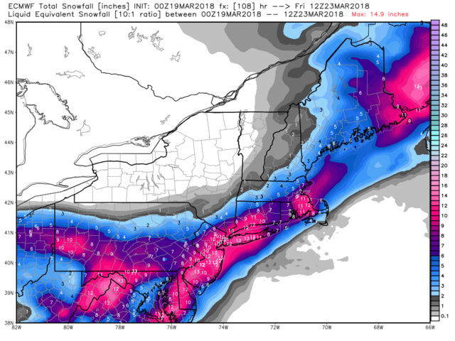
I'm surprised the board not hopping with euro run over a foot for most with ratios. It actually shows some ok cold.
jmanley32- Senior Enthusiast

- Posts : 20648
Join date : 2013-12-12
 Re: Winter's Finale: March 20th-21st Snowstorm
This could finally be NYC and coasts storm but I'm still temper expectations. This looks like now a wed Thurs storm? Meaning 4 days to track ugg it's like hurricane season.
My Holly and Upton have hwo that mention 6 plus more likely NYC tri state and Mt Holly says extensive power outages here we go again. I'm still seeing hundreds of cleanup trucks a day and places that are still not cleaned up from the 2nd!
My Holly and Upton have hwo that mention 6 plus more likely NYC tri state and Mt Holly says extensive power outages here we go again. I'm still seeing hundreds of cleanup trucks a day and places that are still not cleaned up from the 2nd!
Last edited by jmanley32 on Mon Mar 19, 2018 7:35 am; edited 2 times in total

jmanley32- Senior Enthusiast

- Posts : 20648
Reputation : 108
Join date : 2013-12-12
Age : 43
Location : Yonkers, NY
 Re: Winter's Finale: March 20th-21st Snowstorm
Great runs overnight from the EURO,NAM, and GFS. Had a feeling 0z NAM was wrong, hopefully keeps correcting NW. Would assume to see some Winter Storm Watches with the afternoon updates, at least from Mt. Holly anyway
Sanchize06- Senior Enthusiast

- Posts : 1041
Reputation : 21
Join date : 2013-02-05
Location : Union Beach, NJ
 Re: Winter's Finale: March 20th-21st Snowstorm
coastal Upton too I'm if 12s models hold or get better. Nws loves the euro sooo.Sanchize06 wrote:Great runs overnight from the EURO,NAM, and GFS. Had a feeling 0z NAM was wrong, hopefully keeps correcting NW. Would assume to see some Winter Storm Watches with the afternoon updates, at least from Mt. Holly anyway
Wonder if nam trends back to a similar 18z run which was similar to 00z euro.

jmanley32- Senior Enthusiast

- Posts : 20648
Reputation : 108
Join date : 2013-12-12
Age : 43
Location : Yonkers, NY
 Re: Winter's Finale: March 20th-21st Snowstorm
Did u all see rpm woah especially for pa and northern NJ.

jmanley32- Senior Enthusiast

- Posts : 20648
Reputation : 108
Join date : 2013-12-12
Age : 43
Location : Yonkers, NY
 Re: Winter's Finale: March 20th-21st Snowstorm
jmanley32 wrote:Did u all see rpm woah especially for pa and northern NJ.
Jman every thing overnight and this morning is great

skinsfan1177- Senior Enthusiast

- Posts : 4485
Reputation : 35
Join date : 2013-01-07
Age : 47
Location : Point Pleasant Boro
 Re: Winter's Finale: March 20th-21st Snowstorm
IM HERE TEAM. LETS GET ER DONE.
Problem I see I should that it falls during daylight so all kidding aside I think areas away from the concrete island accumulate, but areas with a lot of concrete near and around NYC have a tough time. White rain scenario.
Problem I see I should that it falls during daylight so all kidding aside I think areas away from the concrete island accumulate, but areas with a lot of concrete near and around NYC have a tough time. White rain scenario.
Guest- Guest
 Re: Winter's Finale: March 20th-21st Snowstorm
A lot of factors here complicating this one. To me right now the first wave to come through moves through with generally light precip, during day Tuesday, and since its daytime even if we get some snow from it won’t accumulate much (maybe more south and southwest of us if it’s heavier). Then we have the main event. When does it start, and where is the heaviest precip? If it starts after daybreak Wednesday, areas with lighter precip will not accumulate much but areas with heavy precip will - assuming it’s not mixed with rain. If it starts before daybreak and accumulation has begun by sunrise that may aid in the accumulation during the morning. If it continues after dark Wednesday that also increases accumulation possibilities. Problem is I’ve seen models all over on start and end times, including whether we actually get a break between wave one and two Tuesday night. I hate to say this but I really think we won’t know how this is going to play out until we see where the players are tomorrow morning and what the short range models show through the day tomorrow.

billg315- Advanced Forecaster - Mod

- Posts : 4564
Reputation : 185
Join date : 2015-01-24
Age : 50
Location : Flemington, NJ
 Re: Winter's Finale: March 20th-21st Snowstorm
GFS Ensembles are targeting NYC and points S&E as the bulls-eye for this event. Let's see where 12z runs take us today.


_________________
_______________________________________________________________________________________________________
CLICK HERE to view NJ Strong Snowstorm Classifications
 Re: Winter's Finale: March 20th-21st Snowstorm
Well as expected we have seen models go back and forth; to and fro, and the final soln wouldn't show its self until at least Monday. Pattern recognition and model consistency, these two things will lead the way. The NAM, although has performed relatively well this winter has been very erratic with its surface output the past 24hrs. However it has looked similar at H5 to the Euro. One thing that MUST be kept in mind will be how far the northern frindge of the precip actually gets vs how far north it appears to get in modeling will likely be different. In all likelyhood the northern frindge will be further than modeled.
I don't have the time to do an in depth analysis so I will simply post the EPS individual members snow map trand. Pay little attention to the actual amounts on these maps, but rather the trend in snow axis placement, and notice the number of members zeroing in on a warning criteria type event for the last 4 runs beginning with 12z on the 17th and ending with last nights 00z.
12Z 17th:

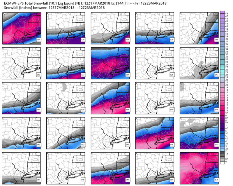
00z 18th:


12z 18th:
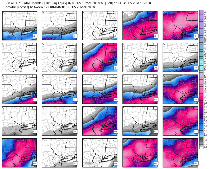

00z 19th:


I don't have the time to do an in depth analysis so I will simply post the EPS individual members snow map trand. Pay little attention to the actual amounts on these maps, but rather the trend in snow axis placement, and notice the number of members zeroing in on a warning criteria type event for the last 4 runs beginning with 12z on the 17th and ending with last nights 00z.
12Z 17th:


00z 18th:


12z 18th:


00z 19th:


Last edited by sroc4 on Mon Mar 19, 2018 3:26 pm; edited 1 time in total
_________________
"In weather and in life, there's no winning and losing; there's only winning and learning."
WINTER 2012/2013 TOTALS 43.65"WINTER 2017/2018 TOTALS 62.85" WINTER 2022/2023 TOTALS 4.9"
WINTER 2013/2014 TOTALS 64.85"WINTER 2018/2019 TOTALS 14.25" WINTER 2023/2024 TOTALS 13.1"
WINTER 2014/2015 TOTALS 71.20"WINTER 2019/2020 TOTALS 6.35" WINTER 2024/2025 TOTALS 0.00
WINTER 2015/2016 TOTALS 35.00"WINTER 2020/2021 TOTALS 37.75"
WINTER 2016/2017 TOTALS 42.25"WINTER 2021/2022 TOTALS 31.65"

sroc4- Admin

- Posts : 8463
Reputation : 302
Join date : 2013-01-07
Location : Wading River, LI
 Re: Winter's Finale: March 20th-21st Snowstorm
Frank_Wx wrote:At this stage of the game I am fairly confident our area will be impacted by our 4th major storm of this month next week. There are unknowns - availability of cold air to the coast, timing, duration, etc - but those will be resolved over the weekend. The purpose of this post will be to examine the pieces and show why we're seeing differences run to run on the models.
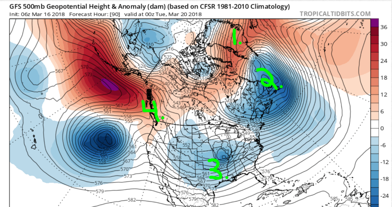
I labeled 4 elements on this 500mb anomaly map valid for Monday night.
1. NAO region
2. 50/50 Low or Confluence region
3. Trough
4. EPO / PNA region
Now take a look at the run to run differences at these 4 locations between the 06z and 00z GFS
The 06z GFS shows a stronger -NAO over Greenland and a more expansive -EPO/+PNA in the western U.S. The confluence area is about the same, more consolidations on the 06z GFS, and the trough is also stronger and more consolidated on the 06z GFS compared to 00z. The biggest takeaway? Models are not done trending with these upper air features. This is the type of system where one small change in the upper atmosphere will create a new solution at the surface on the models.
Let's take a peak at what the upper energy tries to do. The fuchsia circles are key pieces of upper energy critical to the evolution of our storm system. The eastern-most circle is a closed 500mb vort that is responsible for developing a primary low pressure near Oklahoma. This low tracks almost due east, and because of strong temperature and pressure gradients across the north there is a large swath of precipitation that develops in the Midwest that tracks east towards us. Earlier this week we saw some models cut this primary low west near Ohio, but because of the blocking to the north (HP but also a press from the -EPO) models have given up on that solution for the time being. They key is not so much the surface low but the closed 500mb vort. Where does it track and how strong does it get? The 00z GFS showed a weaker 500mb vort so heights along the east coast, coupled with the confluence to the north, remained dampened which kept enough cold air in place for precip to fall in the form of snow. The 06z GFS showed a stronger vort so heights were higher which lead to rising temps and more rain/mix along the coast.
What ends up happening, in my depiction of this whole thing, is the initial 500mb vort breaks apart near the east coast once it "feels" all this blocking in the Atlantic. The 1st half of this system comes from that 500mb vort that broke off the bowling ball upper low in the eastern Pacific. Then we have all these other upper level vorts (the other 3 fuchsia color circles) that are phasing into the trough and creating a brand new 500mb closed low somewhere along the east coast. Where this "2nd" closed low develops will ultimately determine which areas see the greatest amount of snowfall. It is possible some areas see rain/mix from the 1st half of this storm, then depending on where the new 500mb vort forms, see snow the 2nd half. OR some area could stay ALL SNOW for the 1st and 2nd half of this entire event - which is modeled to be greater than 24 hours long.
It is also possible models slow everything down and all these energies consolidate to form just 1 storm. That would eliminate the 2-part storm idea and likely cut down on duration too.
Whatever the case, a very complex storm to forecast and I think someone - as far south as DC to Bawston - could see Godzilla (12"+) or even Roidzilla (24"+) snowfall amounts depending on which scenario comes to fruition. My gut feeling is telling me DC and the Mid-Atlantic is too far south to get into high snow accumulations. I think interior sections, from south-central PA to NEPA, NW NJ, into CT are in a very good spot. The coast, such as Philly to NYC, are on that line. I think these are the cities that could benefit from the "new" closed 500mb vort that develops. These cities could start as rain (from the initial closed 500mb low that raises heights too much) then change to snow later Tuesday or Wednesday. Again, nothing is set in stone but I am just spit balling some realistic scenarios given the time of year.
We'll see what happens.
Happy Tracking - ciao a tutti,
Frank
I want to take a moment to revisit this H5 vort map I posted last Friday:

At the time I explained the scenarios that could play out. Some models were showing a 2-part storm while others were keying in on a specific piece of upper energy as the main show. The eastern-most purple circle on the map above was the initial 500mb closed vort that was shown traverse the country and be our "1st storm." Latest guidance indicates this closed vort will die off - due to the confluent winds to its north - but remnant energy will remain just off the east coast. The 3 other pieces of energy (the other circles) will phase near the Mid-Atlantic, while essentially absorbing the remnant energy, which will develop a coastal storm. Yes, another Nor'easter. Our 4th of the month.

The consolidation of all this energy is due to the aforementioned features in our atmosphere. The -EPO, -NAO, and 50/50 Low all play a role in this. Notice on the graphic above how low heights and northerly winds remain over New England and the higher heights persist over Greenland. The jet stream buckles and all this upper energy has no choice but to tangle and eventually lead to another closed 500mb vort.

The jet streak along the east coast is impressive. The combination of this jet streak and the tight pressure gradients north of the main low will result in periods of moderate to heavy snowfall for cities like Philly to NYC and everyone in between. Where the frontogenesis sets up, or the heaviest snowfall rates, remains to be seen.
We'll see what models tell us today. I am thinking a 6"+ snowfall is likely for NYC and points S&E at this time. Details to come.
_________________
_______________________________________________________________________________________________________
CLICK HERE to view NJ Strong Snowstorm Classifications
 Re: Winter's Finale: March 20th-21st Snowstorm
00z UKIE:


_________________
"In weather and in life, there's no winning and losing; there's only winning and learning."
WINTER 2012/2013 TOTALS 43.65"WINTER 2017/2018 TOTALS 62.85" WINTER 2022/2023 TOTALS 4.9"
WINTER 2013/2014 TOTALS 64.85"WINTER 2018/2019 TOTALS 14.25" WINTER 2023/2024 TOTALS 13.1"
WINTER 2014/2015 TOTALS 71.20"WINTER 2019/2020 TOTALS 6.35" WINTER 2024/2025 TOTALS 0.00
WINTER 2015/2016 TOTALS 35.00"WINTER 2020/2021 TOTALS 37.75"
WINTER 2016/2017 TOTALS 42.25"WINTER 2021/2022 TOTALS 31.65"

sroc4- Admin

- Posts : 8463
Reputation : 302
Join date : 2013-01-07
Location : Wading River, LI
 Re: Winter's Finale: March 20th-21st Snowstorm
Peeps,
Great overnight trends as we are starting to see what we needed and what have done this year with long time WOWZA runs to losing it and causing the frag-i-le members to jump ship and let their pessimistic nature grab hold only to say psyche!
We have the H5 support for a Godzilla scenario for the 2nd feature IMO NYC and points S&E with Monthrazilla for N & W of NYC. And 6" or more for March is YUGGGGGEEEEEEEEE!! Not only early March but late March.
I call on CP or Math t o gives us the stats on said such storms for teh NYC Metro area this late.
Another 50 mile jump NW by models isn't out of the question so let's see what models do today.
NMB have .9" of QPF into NYC - things keep ticking more NW.
The confluence over the NE is dissipating, becoming more with less each run and our phasing is coming together over teh Ohio Valley - well South of that.
Also, the 1st storm is trending more North in its path which will allow this storm to gain more latitude, come up the coast more.
EPS, GEFS & CMC ENS showing a good look and are juicy. Want another tick NW of 25-50 miles NW and a majority of our family will be lovin the white gold!
NMB Not backing down

_________________
Mugs
AKA:King: Snow Weenie
Self Proclaimed
WINTER 2014-15 : 55.12" +.02 for 6 coatings (avg. 35")
WINTER 2015-16 Total - 29.8" (Avg 35")
WINTER 2016-17 : 39.5" so far

amugs- Advanced Forecaster - Mod

- Posts : 15160
Reputation : 213
Join date : 2013-01-07
Age : 54
Location : Hillsdale,NJ
 Re: Winter's Finale: March 20th-21st Snowstorm
I’m actually hoping for a period of moderate to heavy sleet at the onset. This will coat the ground and then give our snow aMUCH BETTER CHANCE of accumulating right from the get go. SCI AT 100%
Guest- Guest
 Re: Winter's Finale: March 20th-21st Snowstorm
jmanley32 wrote:I'm surprised the board not hopping with euro run over a foot for most with ratios.
Ratios won't be worked out until we get to 12Z tomorrow. March sun angle is going to lessen these. If it were Feb this air mass would be in teh 20's adn snow growth would be aorund 12-17:1 for some. But this isn't the case so.
Took this off a site - Look at the confluence all the up into Se Canada - much further North and away so it can climb and also weaker.
Last edited by amugs on Mon Mar 19, 2018 8:51 am; edited 1 time in total
_________________
Mugs
AKA:King: Snow Weenie
Self Proclaimed
WINTER 2014-15 : 55.12" +.02 for 6 coatings (avg. 35")
WINTER 2015-16 Total - 29.8" (Avg 35")
WINTER 2016-17 : 39.5" so far

amugs- Advanced Forecaster - Mod

- Posts : 15160
Reputation : 213
Join date : 2013-01-07
Age : 54
Location : Hillsdale,NJ
 Re: Winter's Finale: March 20th-21st Snowstorm
syosnow94 wrote:I’m actually hoping for a period of moderate to heavy sleet at the onset. This will coat the ground and then give our snow aMUCH BETTER CHANCE of accumulating right from the get go. SCI AT 100%
Jim great point - you want this to start - it will actually cool the ground/surface better and faster and give a layer that will allow the snow stick once it flips.
_________________
Mugs
AKA:King: Snow Weenie
Self Proclaimed
WINTER 2014-15 : 55.12" +.02 for 6 coatings (avg. 35")
WINTER 2015-16 Total - 29.8" (Avg 35")
WINTER 2016-17 : 39.5" so far

amugs- Advanced Forecaster - Mod

- Posts : 15160
Reputation : 213
Join date : 2013-01-07
Age : 54
Location : Hillsdale,NJ
 Re: Winter's Finale: March 20th-21st Snowstorm
amugs wrote:syosnow94 wrote:I’m actually hoping for a period of moderate to heavy sleet at the onset. This will coat the ground and then give our snow aMUCH BETTER CHANCE of accumulating right from the get go. SCI AT 100%
Jim great point - you want this to start - it will actually cool the ground/surface better and faster and give a layer that will allow the snow stick once it flips.
Mugs:
Actually you were reading my mind I just finished posting something in the weather stats thread regarding 6 inch or greater snowfalls in New York City after the spring equinox.

CPcantmeasuresnow- Wx Statistician Guru

- Posts : 7289
Reputation : 230
Join date : 2013-01-07
Age : 103
Location : Eastern Orange County, NY
 Re: Winter's Finale: March 20th-21st Snowstorm
Latest SREFS are Madonne
.thumb.png.9426a06537ede274ee43e96528942470.png)
.thumb.png.9426a06537ede274ee43e96528942470.png)
_________________
_______________________________________________________________________________________________________
CLICK HERE to view NJ Strong Snowstorm Classifications

aiannone- Senior Enthusiast - Mod

- Posts : 4828
Reputation : 92
Join date : 2013-01-07
Location : Saint James, LI (Northwest Suffolk Co.)
 Re: Winter's Finale: March 20th-21st Snowstorm
NMBs - 1-1.25"+ for NYC
ARWs - 1.25-1.5" for NYC
ARWs - 1.25-1.5" for NYC
_________________
_______________________________________________________________________________________________________
CLICK HERE to view NJ Strong Snowstorm Classifications
 Re: Winter's Finale: March 20th-21st Snowstorm
Frank_Wx wrote:Latest SREFS are Madonne
Might indicate 12z NAM will be nice. Big jump in snow totals from 03z runs
_________________
-Alex Iannone-

aiannone- Senior Enthusiast - Mod

- Posts : 4828
Reputation : 92
Join date : 2013-01-07
Location : Saint James, LI (Northwest Suffolk Co.)
 Re: Winter's Finale: March 20th-21st Snowstorm
........By the way when Frank posts about wave 1 leaving excess energy offshore that helps to fuel our nor’easter it is EXACTLY what I posted late last week! I don’t get the science or analysis right that often but when I do you can bet I’m going to point it out. 
Guest- Guest
 Re: Winter's Finale: March 20th-21st Snowstorm
syosnow94 wrote:........By the way when Frank posts about wave 1 leaving excess energy offshore that helps to fuel our nor’easter it is EXACTLY what I posted late last week! I don’t get the science or analysis right that often but when I do you can bet I’m going to point it out.


_________________
_______________________________________________________________________________________________________
CLICK HERE to view NJ Strong Snowstorm Classifications
 Re: Winter's Finale: March 20th-21st Snowstorm
Frank or Alex....Any chance we start as sleet, or at least start before daybreak Wednesday?
Guest- Guest
 Re: Winter's Finale: March 20th-21st Snowstorm
Frank_Wx wrote:syosnow94 wrote:........By the way when Frank posts about wave 1 leaving excess energy offshore that helps to fuel our nor’easter it is EXACTLY what I posted late last week! I don’t get the science or analysis right that often but when I do you can bet I’m going to point it out.


Thanks for the thumbs up GUY
Guest- Guest
 Re: Winter's Finale: March 20th-21st Snowstorm
syosnow94 wrote:Frank or Alex....Any chance we start as sleet, or at least start before daybreak Wednesday?
Yes actually. Any precip that falls late Tuesday or early Wednesday could be as sleet for NYC S&E
_________________
_______________________________________________________________________________________________________
CLICK HERE to view NJ Strong Snowstorm Classifications
Page 12 of 29 •  1 ... 7 ... 11, 12, 13 ... 20 ... 29
Page 12 of 29
Permissions in this forum:
You cannot reply to topics in this forum
 Home
Home