Winter's Finale: March 20th-21st Snowstorm
+53
dsix85
emokid51783
lglickman1
gigs68
essexcountypete
Smittyaj623
Blaze
dsvinos
aiannone
Nyi1058
Math23x7
Scullybutcher
Taffy
jimv45
Artechmetals
oldtimer
Sanchize06
hurrysundown23
moleson
frank 638
Dunnzoo
hyde345
nujerzeedevil
Snow88
Quietace
SoulSingMG
richb521
adamfitz1969
Radz
GreyBeard
nutleyblizzard
CPcantmeasuresnow
bobjohnsonforthehall
mwilli5783
SNOW MAN
RJB8525
mikeypizano
SENJsnowman
jake732
billg315
dkodgis
Grselig
rb924119
sroc4
WeatherBob
weatherwatchermom
algae888
jmanley32
amugs
docstox12
skinsfan1177
Tzvi732
Frank_Wx
57 posters
Page 20 of 29
Page 20 of 29 •  1 ... 11 ... 19, 20, 21 ... 24 ... 29
 Re: Winter's Finale: March 20th-21st Snowstorm
Dear lord eps at those totals the Indies gotta have some roids in there!
jmanley32- Senior Enthusiast

- Posts : 20648
Join date : 2013-12-12
 Re: Winter's Finale: March 20th-21st Snowstorm
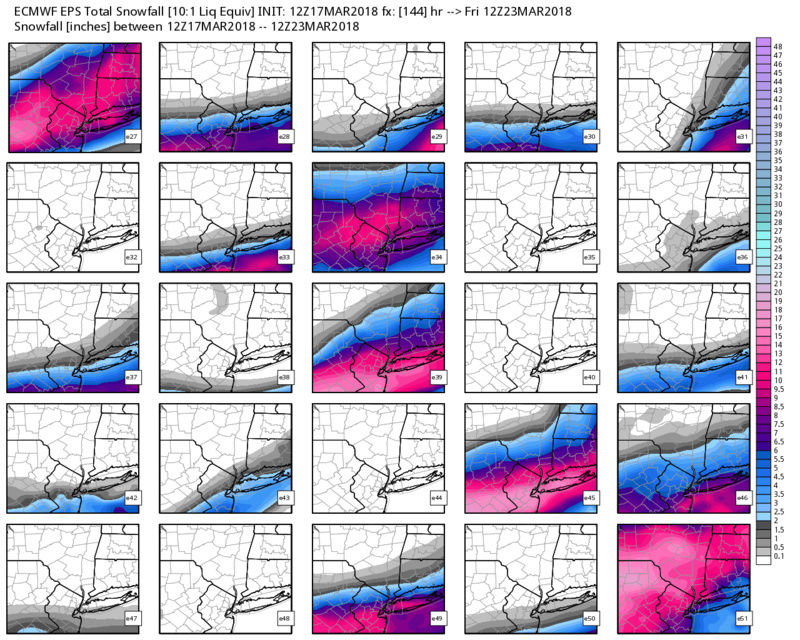
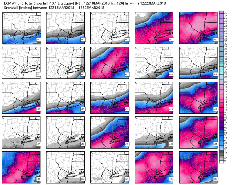
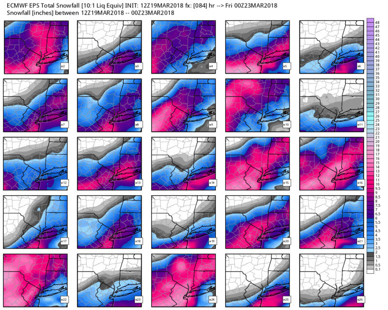
sroc4 wrote:Well as expected we have seen models go back and forth; to and fro, and the final soln wouldn't show its self until at least Monday. Pattern recognition and model consistency, these two things will lead the way. The NAM, although has performed relatively well this winter has been very erratic with its surface output the past 24hrs. However it has looked similar at H5 to the Euro. One thing that MUST be kept in mind will be how far the northern frindge of the precip actually gets vs how far north it appears to get in modeling will likely be different. In all likelyhood the northern frindge will be further than modeled.
I don't have the time to do an in depth analysis so I will simply post the EPS individual members snow map trand. Pay little attention to the actual amounts on these maps, but rather the trend in snow axis placement, and notice the number of members zeroing in on a warning criteria type event for the last 4 runs beginning with 12z on the 17th and ending with last nights 00z.
12Z 17th:
00z 18th:
12z 18th:
00z 19th:
BOOYAA GRANDMA>>>BOOYA!!

sroc4- Admin

- Posts : 8463
Join date : 2013-01-07
 Re: Winter's Finale: March 20th-21st Snowstorm
Good analog for this storm. So it seems...

_________________
_______________________________________________________________________________________________________
CLICK HERE to view NJ Strong Snowstorm Classifications
 Re: Winter's Finale: March 20th-21st Snowstorm
I go to the doctors and come back to this....jeez louise....game time
emokid51783- Posts : 144
Reputation : 5
Join date : 2013-12-12
Age : 41
Location : Jersey City Heights, NJ
jimv45- Senior Enthusiast

- Posts : 1168
Reputation : 36
Join date : 2013-09-20
Location : Hopewell jct.

aiannone- Senior Enthusiast - Mod

- Posts : 4828
Reputation : 92
Join date : 2013-01-07
Location : Saint James, LI (Northwest Suffolk Co.)
 Re: Winter's Finale: March 20th-21st Snowstorm
NWS Mount Holly issues Winter Storm Watch:
WINTER STORM WATCH IN EFFECT FROM TUESDAY EVENING THROUGH
WEDNESDAY EVENING...
* WHAT...Heavy mixed precipitation possible....mainly as snow
though some sleet and light freezing rain is possible Tuesday
night. Total snow accumulations of 5 to 8 inches, with
localized amounts up to 12 inches, and ice accumulations of up
to one tenth of an inch are possible.
* WHERE...Portions of northern and northwest New Jersey and east
central, northeast and southeast Pennsylvania.
* WHEN...From Tuesday evening through Wednesday evening.
* ADDITIONAL DETAILS...Plan on difficult travel conditions,
including during the evening commute on Wednesday. Significant
reductions in visibility are possible. Roads in the hilly areas
may become impassable if 1 to 3 inch per hour snowfall rates
develop as expected Wednesday afternoon. Power outages are
possible. Northeast to north winds should gust 20 to 30 mph at
times.
PRECAUTIONARY/PREPAREDNESS ACTIONS...
A Winter Storm Watch means there is potential for significant
snow, sleet or ice accumulations that may impact travel. Continue
to monitor the latest forecasts.

billg315- Advanced Forecaster - Mod

- Posts : 4564
Reputation : 185
Join date : 2015-01-24
Age : 50
Location : Flemington, NJ
 Re: Winter's Finale: March 20th-21st Snowstorm
Still nothing for me from Upton.

Taffy- Pro Enthusiast

- Posts : 530
Reputation : 19
Join date : 2013-10-06
Location : Hopkinton, MA
 Re: Winter's Finale: March 20th-21st Snowstorm
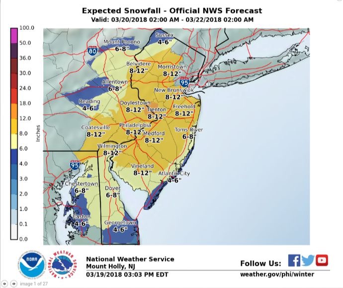
aiannone wrote:Updated Mt Holly map
ok now I am excited!!
https://www.youtube.com/watch?v=i6zaVYWLTkU

weatherwatchermom- Senior Enthusiast

- Posts : 3897
Reputation : 78
Join date : 2014-11-25
Location : Hazlet Township, NJ
 Re: Winter's Finale: March 20th-21st Snowstorm
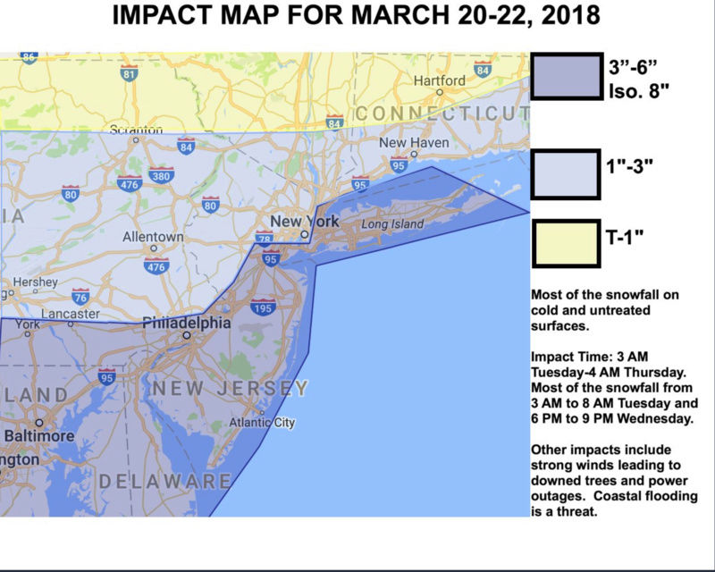
And as always, the ass backwards steve D map that he changes during the storm!

_________________
-Alex Iannone-

aiannone- Senior Enthusiast - Mod

- Posts : 4828
Reputation : 92
Join date : 2013-01-07
Location : Saint James, LI (Northwest Suffolk Co.)
 Re: Winter's Finale: March 20th-21st Snowstorm
^ 


_________________
_______________________________________________________________________________________________________
CLICK HERE to view NJ Strong Snowstorm Classifications
 Re: Winter's Finale: March 20th-21st Snowstorm
Upton always last it's coming relax prolly be a bit more conservative but I think 8 to 12 going right across from Jersey is in fair play.

jmanley32- Senior Enthusiast

- Posts : 20648
Reputation : 108
Join date : 2013-12-12
Age : 43
Location : Yonkers, NY
 Re: Winter's Finale: March 20th-21st Snowstorm
Upton right now has wsw for northern counties of ct WTH. I thought the coast was go benefit. Has same as nj. In between nothing noted how can that b

jmanley32- Senior Enthusiast

- Posts : 20648
Reputation : 108
Join date : 2013-12-12
Age : 43
Location : Yonkers, NY
 Re: Winter's Finale: March 20th-21st Snowstorm
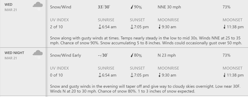
Here is the latest for LI from TWC for what it's worth:

_________________
-Alex Iannone-

aiannone- Senior Enthusiast - Mod

- Posts : 4828
Reputation : 92
Join date : 2013-01-07
Location : Saint James, LI (Northwest Suffolk Co.)
 Re: Winter's Finale: March 20th-21st Snowstorm
Coastal Flood Advisory up for Suffolk.
dsix85- Pro Enthusiast

- Posts : 351
Reputation : 8
Join date : 2014-01-01
Location : New York
 Re: Winter's Finale: March 20th-21st Snowstorm
Alex- that forecast has been posted since 7am this morning FYI.
dsix85- Pro Enthusiast

- Posts : 351
Reputation : 8
Join date : 2014-01-01
Location : New York
 Re: Winter's Finale: March 20th-21st Snowstorm
jmanley32 wrote:Upton right now has wsw for northern counties of ct WTH. I thought the coast was go benefit. Has same as nj. In between nothing noted how can that b
The area you are describing is Albany's CWA
_________________
-Alex Iannone-

aiannone- Senior Enthusiast - Mod

- Posts : 4828
Reputation : 92
Join date : 2013-01-07
Location : Saint James, LI (Northwest Suffolk Co.)
 Re: Winter's Finale: March 20th-21st Snowstorm
dsix85 wrote:Alex- that forecast has been posted since 7am this morning FYI.
If you are referring to Steve D's map, his latest tweet says he's still happy with it
_________________
-Alex Iannone-

aiannone- Senior Enthusiast - Mod

- Posts : 4828
Reputation : 92
Join date : 2013-01-07
Location : Saint James, LI (Northwest Suffolk Co.)
 Re: Winter's Finale: March 20th-21st Snowstorm
I expect Upton will update soon.

jmanley32- Senior Enthusiast

- Posts : 20648
Reputation : 108
Join date : 2013-12-12
Age : 43
Location : Yonkers, NY
 Re: Winter's Finale: March 20th-21st Snowstorm
WSW now posted for Suffolk
dsix85- Pro Enthusiast

- Posts : 351
Reputation : 8
Join date : 2014-01-01
Location : New York
 Re: Winter's Finale: March 20th-21st Snowstorm
aiannone wrote:dsix85 wrote:Alex- that forecast has been posted since 7am this morning FYI.
If you are referring to Steve D's map, his latest tweet says he's still happy with it
No I was referring to The Weather Channel App
dsix85- Pro Enthusiast

- Posts : 351
Reputation : 8
Join date : 2014-01-01
Location : New York
 Re: Winter's Finale: March 20th-21st Snowstorm
Lol literally the minute I typed that I got my wsw alert 5 to 11 higher possible wet snow. Add wind we got more power issues coming.

jmanley32- Senior Enthusiast

- Posts : 20648
Reputation : 108
Join date : 2013-12-12
Age : 43
Location : Yonkers, NY
 Re: Winter's Finale: March 20th-21st Snowstorm
jmanley32 wrote:Lol literally the minute I typed that I got my wsw alert 5 to 11 higher possible wet snow. Add wind we got more power issues coming.
they heard you

RJB8525- Senior Enthusiast

- Posts : 1994
Reputation : 28
Join date : 2013-02-06
Age : 38
Location : Hackettstown, NJ
 Re: Winter's Finale: March 20th-21st Snowstorm
352 PM EDT Mon Mar 19 2018
...WINTER STORM WATCH IN EFFECT FROM LATE TUESDAY NIGHT THROUGH
LATE WEDNESDAY NIGHT...
* WHAT...Heavy wet snow possible. Total wet snow accumulations of
5 to 9 inches, with locally higher amounts possible.
* WHERE...Long Island and southern Connecticut.
* WHEN...From late Tuesday night through late Wednesday night.
* ADDITIONAL DETAILS...Plan on difficult travel conditions,
including during the evening commute on Wednesday. Tree
branches could fall. Significant reductions in visibility are
possible.
_________________
-Alex Iannone-

aiannone- Senior Enthusiast - Mod

- Posts : 4828
Reputation : 92
Join date : 2013-01-07
Location : Saint James, LI (Northwest Suffolk Co.)
 Re: Winter's Finale: March 20th-21st Snowstorm
are we going to chat tonight?

weatherwatchermom- Senior Enthusiast

- Posts : 3897
Reputation : 78
Join date : 2014-11-25
Location : Hazlet Township, NJ
 Re: Winter's Finale: March 20th-21st Snowstorm
What the ceiling for this event on the higer end? In nyc
Carter bk- Posts : 73
Reputation : 5
Join date : 2017-12-07
 Re: Winter's Finale: March 20th-21st Snowstorm
jmanley32 wrote:Lol literally the minute I typed that I got my wsw alert 5 to 11 higher possible wet snow. Add wind we got more power issues coming.
Exactly, Jman. No sooner had I typed that Upton hadn't issued one.....and there it is

Taffy- Pro Enthusiast

- Posts : 530
Reputation : 19
Join date : 2013-10-06
Location : Hopkinton, MA
Page 20 of 29 •  1 ... 11 ... 19, 20, 21 ... 24 ... 29
Page 20 of 29
Permissions in this forum:
You cannot reply to topics in this forum
 Home
Home
