
 Search
Feb. 11-12 2019 Wintry Mix Event
Page 6 of 16 •  1 ... 5, 6, 7 ... 11 ... 16
 ![]()
Re: Feb. 11-12 2019 Wintry Mix Event
![]() by DAYBLAZER Mon Feb 11, 2019 11:36 am
by DAYBLAZER Mon Feb 11, 2019 11:36 am
billg315 wrote:DAYBLAZER wrote:According to the latest forecast for Hopatcong, they are calling for anywhere from 3-6 inches (possibly more if the cold air hangs on) followed by a prolonged period of sleet and potentially freezing rain, up to 1/4 inch possible.
The second half of that forecast concerns me far more than the snow. It would be very unusual to have such a prolonged period of sleet/ice and I think that's what could end being the real story up here.
Now I know that ice forecasts generally bust in this area. Is there any indication that this storm will be any different and buck that trend?
Most of the models are pretty consistent on keeping the cold in place at the lower levels for prolonged sleet and freezing rain, so while its not common, I wouldn't be surprised if that's the way it goes. Where you are I think you will get a nice front end thump of snow, because the warm upper levels will take longer to move in there so the transition from snow to sleet (which may happen quickly for some people especially if this starts late) will take longer there.
Interesting. Well I'll take whatever I can get at this point. Thanks for the insight
I also see the morning commute being extremely impacted if the timing of this holds true. If this thing doesn't get going until 4-5 AM, you may have quite the situation on the roads if people leave for work under the impression that this will all quickly transition to rain. I'm thinking the I-80 and I-78 corridors are especially at risk here.
DAYBLAZER- Posts : 228
Join date : 2017-03-12
Re: Feb. 11-12 2019 Wintry Mix Event
![]() by billg315 Mon Feb 11, 2019 11:42 am
by billg315 Mon Feb 11, 2019 11:42 am
billg315- Advanced Forecaster - Mod

- Posts : 4558
Join date : 2015-01-24
Re: Feb. 11-12 2019 Wintry Mix Event
![]() by billg315 Mon Feb 11, 2019 11:44 am
by billg315 Mon Feb 11, 2019 11:44 am
DAYBLAZER wrote:billg315 wrote:DAYBLAZER wrote:According to the latest forecast for Hopatcong, they are calling for anywhere from 3-6 inches (possibly more if the cold air hangs on) followed by a prolonged period of sleet and potentially freezing rain, up to 1/4 inch possible.
The second half of that forecast concerns me far more than the snow. It would be very unusual to have such a prolonged period of sleet/ice and I think that's what could end being the real story up here.
Now I know that ice forecasts generally bust in this area. Is there any indication that this storm will be any different and buck that trend?
Most of the models are pretty consistent on keeping the cold in place at the lower levels for prolonged sleet and freezing rain, so while its not common, I wouldn't be surprised if that's the way it goes. Where you are I think you will get a nice front end thump of snow, because the warm upper levels will take longer to move in there so the transition from snow to sleet (which may happen quickly for some people especially if this starts late) will take longer there.
Interesting. Well I'll take whatever I can get at this point. Thanks for the insight
I also see the morning commute being extremely impacted if the timing of this holds true. If this thing doesn't get going until 4-5 AM, you may have quite the situation on the roads if people leave for work under the impression that this will all quickly transition to rain. I'm thinking the I-80 and I-78 corridors are especially at risk here.
In a way, a later start could make this worse (thinking back to November). If we had a few hours of snow before the rush hour, many people might just stay home. But if the snow is just starting at rush hour and then changes over to prolonged sleet, many people will be on the roads already as they deteriorate. I think for most people north of I-78 the PM rush could be a mess too.

billg315- Advanced Forecaster - Mod
- Posts : 4558
Reputation : 185
Join date : 2015-01-24
Age : 50
Location : Flemington, NJ
Re: Feb. 11-12 2019 Wintry Mix Event
![]() by Dunnzoo Mon Feb 11, 2019 12:15 pm
by Dunnzoo Mon Feb 11, 2019 12:15 pm
_________________
Janet
Snowfall winter of 2023-2024 17.5"
Snowfall winter of 2022-2023 6.0"
Snowfall winter of 2021-2022 17.6" 1" sleet 2/25/22
Snowfall winter of 2020-2021 51.1"
Snowfall winter of 2019-2020 8.5"
Snowfall winter of 2018-2019 25.1"
Snowfall winter of 2017-2018 51.9"
Snowfall winter of 2016-2017 45.6"
Snowfall winter of 2015-2016 29.5"
Snowfall winter of 2014-2015 50.55"
Snowfall winter of 2013-2014 66.5"

Dunnzoo- Senior Enthusiast - Mod
- Posts : 4934
Reputation : 68
Join date : 2013-01-11
Age : 62
Location : Westwood, NJ
Re: Feb. 11-12 2019 Wintry Mix Event
![]() by DAYBLAZER Mon Feb 11, 2019 12:27 pm
by DAYBLAZER Mon Feb 11, 2019 12:27 pm

DAYBLAZER- Posts : 228
Reputation : 20
Join date : 2017-03-12
Location : Hopatcong, NJ Sussex County
Re: Feb. 11-12 2019 Wintry Mix Event
![]() by DAYBLAZER Mon Feb 11, 2019 12:30 pm
by DAYBLAZER Mon Feb 11, 2019 12:30 pm
I ask because I know there was a big discrepancy between models as far as start time, so I'm curious as to what any more experienced Mets out there are seeing as this thing sets up.
DAYBLAZER- Posts : 228
Reputation : 20
Join date : 2017-03-12
Location : Hopatcong, NJ Sussex County
Re: Feb. 11-12 2019 Wintry Mix Event
![]() by le88kb Mon Feb 11, 2019 1:13 pm
by le88kb Mon Feb 11, 2019 1:13 pm

le88kb- Posts : 12
Reputation : 0
Join date : 2013-12-12
Location : Pequannock Nj
Re: Feb. 11-12 2019 Wintry Mix Event
![]() by amugs Mon Feb 11, 2019 2:28 pm
by amugs Mon Feb 11, 2019 2:28 pm
le88kb wrote:are we talking a wash away rain or just making a mess rain . need to plan company plowing .
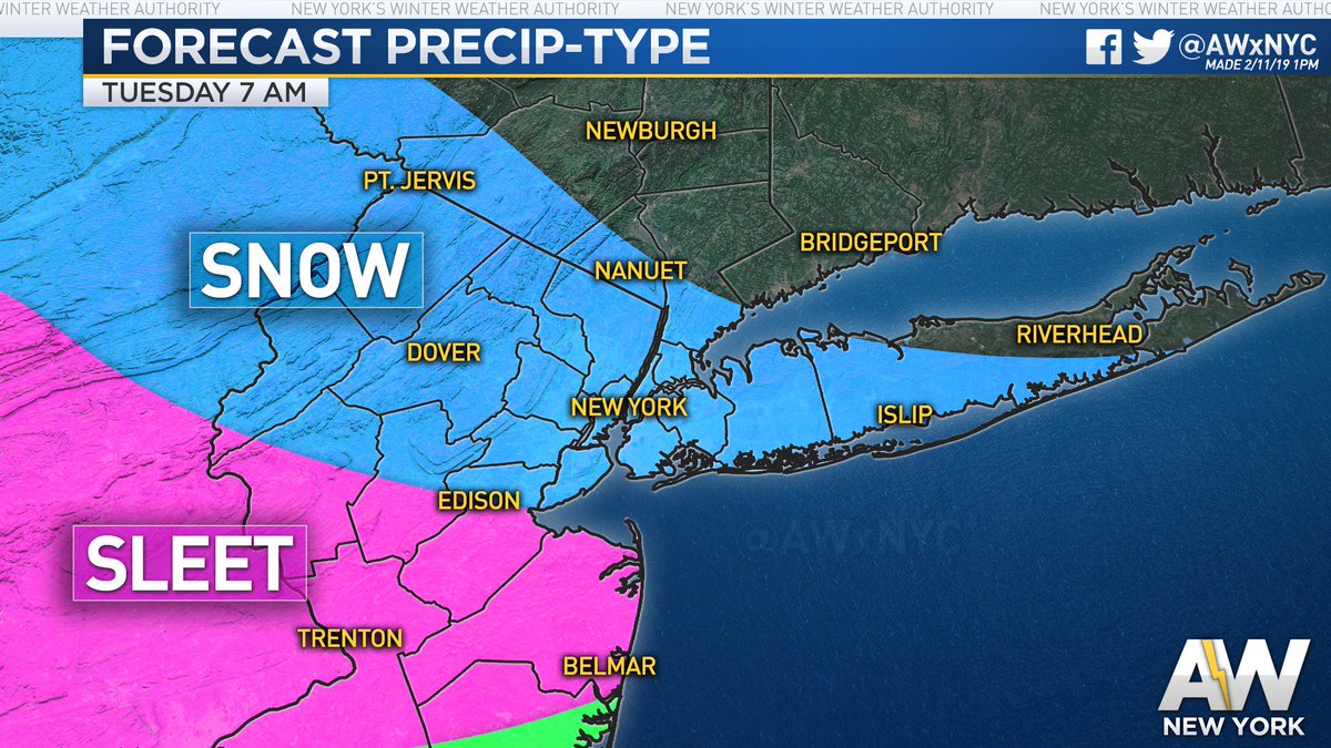
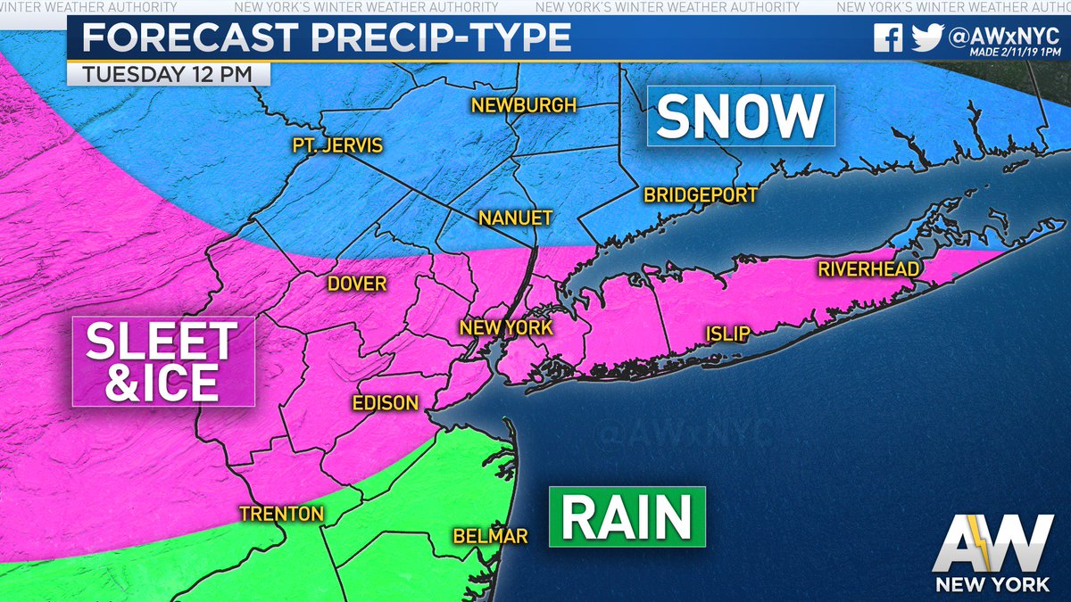
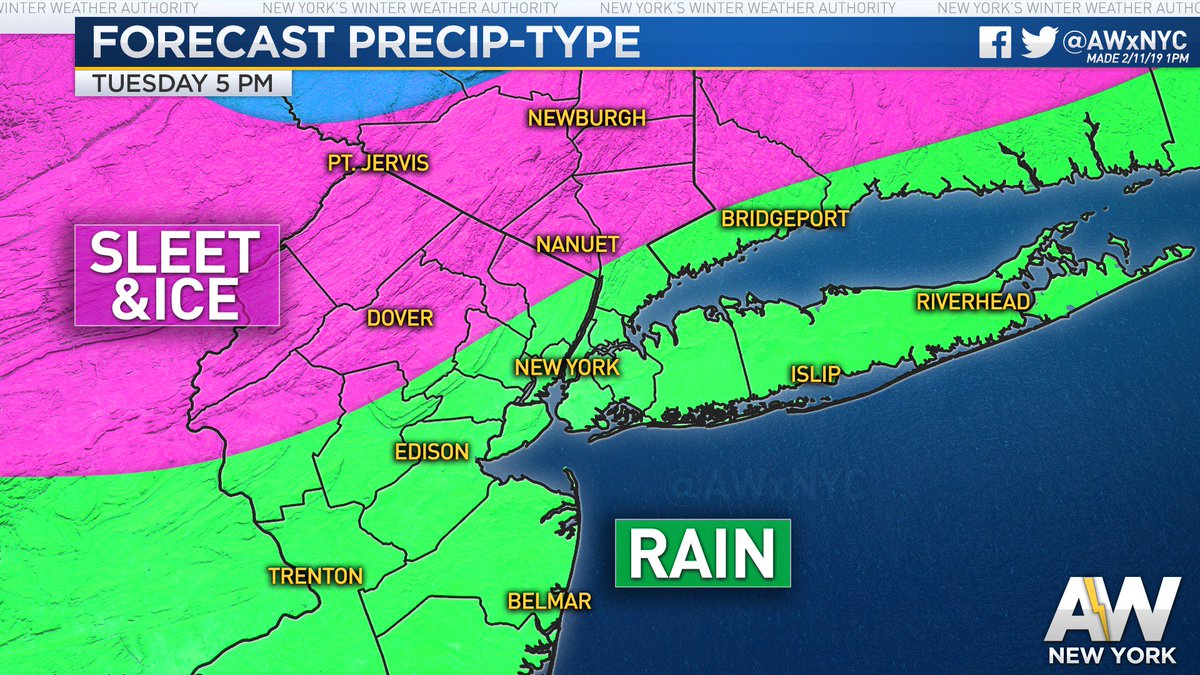
For you in Pequonneck it will be a A LOT of sleet and the rains may not come in until 8-9PM - and that is the back end of the storm with little rains. The latest EURO is much colder at the surface and at the mid levels of 850 and 700 as well as at the surface. We need to see if other guidance follows this suite the 12Z GFS was teh first to show this and then the NAM and now the EURO so a colder solution seems to be on tap - less front end snow overall but way more sleet and possible ZR as we transition into rain for NNJ peeps.
Here the progressions:


COLD AIR HANGING TOUGH

This would be bad.
_________________
Mugs
AKA:King: Snow Weenie
Self Proclaimed
WINTER 2014-15 : 55.12" +.02 for 6 coatings (avg. 35")
WINTER 2015-16 Total - 29.8" (Avg 35")
WINTER 2016-17 : 39.5" so far

amugs- Advanced Forecaster - Mod
- Posts : 15148
Reputation : 213
Join date : 2013-01-07
Age : 54
Location : Hillsdale,NJ
Re: Feb. 11-12 2019 Wintry Mix Event
![]() by docstox12 Mon Feb 11, 2019 2:34 pm
by docstox12 Mon Feb 11, 2019 2:34 pm
amugs wrote:le88kb wrote:are we talking a wash away rain or just making a mess rain . need to plan company plowing .
For you in Pequonneck it will be a A LOT of sleet and the rains may not come in until 8-9PM - and that is the back end of the storm with little rains. The latest EURO is much colder at the surface and at the mid levels of 850 and 700 as well as at the surface. We need to see if other guidance follows this suite the 12Z GFS was teh first to show this and then the NAM and now the EURO so a colder solution seems to be on tap - less front end snow overall but way more sleet and possible ZR as we transition into rain for NNJ peeps.
Here the progressions:
COLD AIR HANGING TOUGH
Ugh! I am starting to forget what an all snow 12 inch event is like, it's been nearly 3 months here since that occurred Nov 15th.Enough with these slop scenarios already
This would be bad.

docstox12- Wx Statistician Guru

- Posts : 8611
Reputation : 222
Join date : 2013-01-07
Age : 74
Location : Monroe NY
Re: Feb. 11-12 2019 Wintry Mix Event
![]() by DAYBLAZER Mon Feb 11, 2019 2:35 pm
by DAYBLAZER Mon Feb 11, 2019 2:35 pm
DAYBLAZER- Posts : 228
Reputation : 20
Join date : 2017-03-12
Location : Hopatcong, NJ Sussex County
Re: Feb. 11-12 2019 Wintry Mix Event
![]() by amugs Mon Feb 11, 2019 3:01 pm
by amugs Mon Feb 11, 2019 3:01 pm
DAY it is just showing how you hold onto the cold through the 8PM hour as Sleet adn ZR as teh surface temps are about 30* up by you.DAYBLAZER wrote:Unfortunately I can't view whatever maps you just posted Amugs...I get an access forbidden message. Perhaps it's just my computer though.
This has evolved from a snowstorm to an ice storm basically but it wont qualify as one.
_________________
Mugs
AKA:King: Snow Weenie
Self Proclaimed
WINTER 2014-15 : 55.12" +.02 for 6 coatings (avg. 35")
WINTER 2015-16 Total - 29.8" (Avg 35")
WINTER 2016-17 : 39.5" so far
amugs- Advanced Forecaster - Mod
- Posts : 15148
Reputation : 213
Join date : 2013-01-07
Age : 54
Location : Hillsdale,NJ
Re: Feb. 11-12 2019 Wintry Mix Event
![]() by DAYBLAZER Mon Feb 11, 2019 3:06 pm
by DAYBLAZER Mon Feb 11, 2019 3:06 pm
amugs wrote:DAY it is just showing how you hold onto the cold through the 8PM hour as Sleet adn ZR as teh surface temps are about 30* up by you.
This has evolved from a snowstorm to an ice storm basically but it wont qualify as one.
Gotcha. So I'm guessing I shouldn't be heading to work tomorrow morning. Start time still looking around 3-4 AM?
Also curious why won't this qualify as an ice storm up here? More sleet than ice?
DAYBLAZER- Posts : 228
Reputation : 20
Join date : 2017-03-12
Location : Hopatcong, NJ Sussex County
Re: Feb. 11-12 2019 Wintry Mix Event
![]() by frank 638 Mon Feb 11, 2019 3:11 pm
by frank 638 Mon Feb 11, 2019 3:11 pm
frank 638- Senior Enthusiast

- Posts : 2880
Reputation : 37
Join date : 2016-01-01
Age : 41
Location : bronx ny
Re: Feb. 11-12 2019 Wintry Mix Event
![]() by billg315 Mon Feb 11, 2019 3:28 pm
by billg315 Mon Feb 11, 2019 3:28 pm
Frank, right now, NYC does not appear to go to all rain until after 5 p.m.
billg315- Advanced Forecaster - Mod
- Posts : 4558
Reputation : 185
Join date : 2015-01-24
Age : 50
Location : Flemington, NJ
Re: Feb. 11-12 2019 Wintry Mix Event
![]() by heehaw453 Mon Feb 11, 2019 3:33 pm
by heehaw453 Mon Feb 11, 2019 3:33 pm
URGENT - WINTER WEATHER MESSAGE
National Weather Service Mount Holly NJ
330 PM EST Mon Feb 11 2019
PAZ060-061-103-105-121100-
/O.UPG.KPHI.WW.Y.0009.190212T0000Z-190213T0000Z/
/O.NEW.KPHI.WS.W.0004.190211T2300Z-190213T0500Z/
Berks-Lehigh-Western Montgomery-Upper Bucks-
Including the cities of Reading, Allentown, Collegeville,
Pottstown, Chalfont, and Perkasie
330 PM EST Mon Feb 11 2019
...WINTER STORM WARNING IN EFFECT UNTIL MIDNIGHT EST TUESDAY
NIGHT...
* WHAT...Heavy mixed precipitation expected. Total snow
accumulations of 5 to 7 inches and ice accumulations of one
tenth to two tenths of an inch expected.
* WHERE...Berks, Lehigh, Western Montgomery and Upper Bucks
counties.
* WHEN...Until midnight EST Tuesday night.
* ADDITIONAL DETAILS...Travel could be very difficult. The
hazardous conditions could impact the morning or evening commute
on Tuesday.
PRECAUTIONARY/PREPAREDNESS ACTIONS...
A Winter Storm Warning means significant amounts of snow, sleet
and ice will make travel very hazardous or impossible.
The latest road conditions for the state you are calling from can
be obtained by calling 5 1 1.
heehaw453- Advanced Forecaster

- Posts : 3931
Reputation : 86
Join date : 2014-01-20
Location : Bedminster Township, PA Elevation 600' ASL
Re: Feb. 11-12 2019 Wintry Mix Event
![]() by algae888 Mon Feb 11, 2019 3:35 pm
by algae888 Mon Feb 11, 2019 3:35 pm

algae888- Advanced Forecaster
- Posts : 5311
Reputation : 46
Join date : 2013-02-05
Age : 62
Location : mt. vernon, new york
Re: Feb. 11-12 2019 Wintry Mix Event
![]() by amugs Mon Feb 11, 2019 3:35 pm
by amugs Mon Feb 11, 2019 3:35 pm
DAYBLAZER wrote:amugs wrote:DAY it is just showing how you hold onto the cold through the 8PM hour as Sleet adn ZR as teh surface temps are about 30* up by you.
This has evolved from a snowstorm to an ice storm basically but it wont qualify as one.
Gotcha. So I'm guessing I shouldn't be heading to work tomorrow morning. Start time still looking around 3-4 AM?
Also curious why won't this qualify as an ice storm up here? More sleet than ice?
Yes at this time it should start around that time frame.
I do not know the criteria for ice storm warnings but I woudl say you are close to that.
From Allan weather - and I think he nails this pretty well
_________________
Mugs
AKA:King: Snow Weenie
Self Proclaimed
WINTER 2014-15 : 55.12" +.02 for 6 coatings (avg. 35")
WINTER 2015-16 Total - 29.8" (Avg 35")
WINTER 2016-17 : 39.5" so far
amugs- Advanced Forecaster - Mod
- Posts : 15148
Reputation : 213
Join date : 2013-01-07
Age : 54
Location : Hillsdale,NJ
Re: Feb. 11-12 2019 Wintry Mix Event
![]() by amugs Mon Feb 11, 2019 3:42 pm
by amugs Mon Feb 11, 2019 3:42 pm
NJZ009-010-121100-
/O.UPG.KPHI.WW.Y.0009.190212T0500Z-190213T0000Z/
/O.NEW.KPHI.WS.W.0004.190211T2300Z-190213T0500Z/
HUNTERDON-SOMERSET-
INCLUDING THE CITIES OF FLEMINGTON AND SOMERVILLE
330 PM EST MON FEB 11 2019
...WINTER STORM WARNING IN EFFECT UNTIL MIDNIGHT EST TUESDAY
NIGHT...
* WHAT...HEAVY MIXED PRECIPITATION EXPECTED. TOTAL SNOW
ACCUMULATIONS OF 4 TO 6 INCHES AND ICE ACCUMULATIONS OF ONE
TENTH TO TWO TENTHS OF AN INCH EXPECTED.
* WHERE...HUNTERDON AND SOMERSET COUNTIES.
* WHEN...UNTIL MIDNIGHT EST TUESDAY NIGHT.
* ADDITIONAL DETAILS...TRAVEL COULD BE VERY DIFFICULT. THE
HAZARDOUS CONDITIONS COULD IMPACT THE MORNING AND EVENING
COMMUTES ON TUESDAY.
PRECAUTIONARY/PREPAREDNESS ACTIONS...
A WINTER STORM WARNING MEANS SIGNIFICANT AMOUNTS OF SNOW, SLEET
AND ICE WILL MAKE TRAVEL VERY HAZARDOUS OR IMPOSSIBLE.
THE LATEST ROAD CONDITIONS FOR THE STATE YOU ARE CALLING FROM CAN
BE OBTAINED BY CALLING 5 1 1.
NJZ001-PAZ054-055-121100-
/O.UPG.KPHI.WS.A.0003.190212T0500Z-190213T0600Z/
/O.NEW.KPHI.WS.W.0004.190212T0500Z-190213T1100Z/
SUSSEX-CARBON-MONROE-
INCLUDING THE CITIES OF NEWTON, JIM THORPE, AND STROUDSBURG
330 PM EST MON FEB 11 2019
...WINTER STORM WARNING IN EFFECT FROM MIDNIGHT TONIGHT TO 6 AM
EST WEDNESDAY...
* WHAT...HEAVY MIXED PRECIPITATION EXPECTED. TOTAL SNOW
ACCUMULATIONS OF 4 TO 7 INCHES AND ICE ACCUMULATIONS OF ONE
TENTH TO TWO TENTHS OF AN INCH EXPECTED.
* WHERE...IN NEW JERSEY, SUSSEX COUNTY. IN PENNSYLVANIA, CARBON
AND MONROE COUNTIES.
* WHEN...FROM MIDNIGHT TONIGHT TO 6 AM EST WEDNESDAY.
* ADDITIONAL DETAILS...TRAVEL COULD BE VERY DIFFICULT. THE
HAZARDOUS CONDITIONS COULD IMPACT THE MORNING OR EVENING
COMMUTE ON TUESDAY.
PRECAUTIONARY/PREPAREDNESS ACTIONS...
A WINTER STORM WARNING MEANS SIGNIFICANT AMOUNTS OF SNOW, SLEET
AND ICE WILL MAKE TRAVEL VERY HAZARDOUS OR IMPOSSIBLE.
THE LATEST ROAD CONDITIONS FOR THE STATE YOU ARE CALLING FROM CAN
BE OBTAINED BY CALLING 5 1 1.
_________________
Mugs
AKA:King: Snow Weenie
Self Proclaimed
WINTER 2014-15 : 55.12" +.02 for 6 coatings (avg. 35")
WINTER 2015-16 Total - 29.8" (Avg 35")
WINTER 2016-17 : 39.5" so far
amugs- Advanced Forecaster - Mod
- Posts : 15148
Reputation : 213
Join date : 2013-01-07
Age : 54
Location : Hillsdale,NJ
Re: Feb. 11-12 2019 Wintry Mix Event
![]() by billg315 Mon Feb 11, 2019 3:45 pm
by billg315 Mon Feb 11, 2019 3:45 pm
amugs wrote:NWS not buying NAM but we'll see where other guidance is at
NJZ009-010-121100-
/O.UPG.KPHI.WW.Y.0009.190212T0500Z-190213T0000Z/
/O.NEW.KPHI.WS.W.0004.190211T2300Z-190213T0500Z/
HUNTERDON-SOMERSET-
INCLUDING THE CITIES OF FLEMINGTON AND SOMERVILLE
330 PM EST MON FEB 11 2019
...WINTER STORM WARNING IN EFFECT UNTIL MIDNIGHT EST TUESDAY
NIGHT...
* WHAT...HEAVY MIXED PRECIPITATION EXPECTED. TOTAL SNOW
ACCUMULATIONS OF 4 TO 6 INCHES AND ICE ACCUMULATIONS OF ONE
TENTH TO TWO TENTHS OF AN INCH EXPECTED.
* WHERE...HUNTERDON AND SOMERSET COUNTIES.
* WHEN...UNTIL MIDNIGHT EST TUESDAY NIGHT.
* ADDITIONAL DETAILS...TRAVEL COULD BE VERY DIFFICULT. THE
HAZARDOUS CONDITIONS COULD IMPACT THE MORNING AND EVENING
COMMUTES ON TUESDAY.
PRECAUTIONARY/PREPAREDNESS ACTIONS...
A WINTER STORM WARNING MEANS SIGNIFICANT AMOUNTS OF SNOW, SLEET
AND ICE WILL MAKE TRAVEL VERY HAZARDOUS OR IMPOSSIBLE.
THE LATEST ROAD CONDITIONS FOR THE STATE YOU ARE CALLING FROM CAN
BE OBTAINED BY CALLING 5 1 1.
NJZ001-PAZ054-055-121100-
/O.UPG.KPHI.WS.A.0003.190212T0500Z-190213T0600Z/
/O.NEW.KPHI.WS.W.0004.190212T0500Z-190213T1100Z/
SUSSEX-CARBON-MONROE-
INCLUDING THE CITIES OF NEWTON, JIM THORPE, AND STROUDSBURG
330 PM EST MON FEB 11 2019
...WINTER STORM WARNING IN EFFECT FROM MIDNIGHT TONIGHT TO 6 AM
EST WEDNESDAY...
* WHAT...HEAVY MIXED PRECIPITATION EXPECTED. TOTAL SNOW
ACCUMULATIONS OF 4 TO 7 INCHES AND ICE ACCUMULATIONS OF ONE
TENTH TO TWO TENTHS OF AN INCH EXPECTED.
* WHERE...IN NEW JERSEY, SUSSEX COUNTY. IN PENNSYLVANIA, CARBON
AND MONROE COUNTIES.
* WHEN...FROM MIDNIGHT TONIGHT TO 6 AM EST WEDNESDAY.
* ADDITIONAL DETAILS...TRAVEL COULD BE VERY DIFFICULT. THE
HAZARDOUS CONDITIONS COULD IMPACT THE MORNING OR EVENING
COMMUTE ON TUESDAY.
PRECAUTIONARY/PREPAREDNESS ACTIONS...
A WINTER STORM WARNING MEANS SIGNIFICANT AMOUNTS OF SNOW, SLEET
AND ICE WILL MAKE TRAVEL VERY HAZARDOUS OR IMPOSSIBLE.
THE LATEST ROAD CONDITIONS FOR THE STATE YOU ARE CALLING FROM CAN
BE OBTAINED BY CALLING 5 1 1.
Yeah mugs, that includes my area. They seem to believe the precipitation starts earlier than the NAM and that it stays snow longer before the change to sleet. That is the only way to get to those higher (4-6") totals. We shall see how this all plays out tomorrow, but it is going to be a very interesting nowcast as it happens!
billg315- Advanced Forecaster - Mod
- Posts : 4558
Reputation : 185
Join date : 2015-01-24
Age : 50
Location : Flemington, NJ
Re: Feb. 11-12 2019 Wintry Mix Event
![]() by Frankdp23 Mon Feb 11, 2019 4:19 pm
by Frankdp23 Mon Feb 11, 2019 4:19 pm
Yeah mugs, that includes my area. They seem to believe the precipitation starts earlier than the NAM and that it stays snow longer before the change to sleet. That is the only way to get to those higher (4-6") totals. We shall see how this all plays out tomorrow, but it is going to be a very interesting nowcast as it happens![/quote]
I'm in the town next door to you right on the border of Hunterdon Co. I'm a little surprised they went this high. I agree though that it needs to come in earlier to even get to the low end of those projected totals.
Frankdp23- Posts : 11
Reputation : 1
Join date : 2018-02-28
Age : 46
Location : Branchburg, NJ
Re: Feb. 11-12 2019 Wintry Mix Event
![]() by billg315 Mon Feb 11, 2019 4:27 pm
by billg315 Mon Feb 11, 2019 4:27 pm
Frankdp23 wrote:
Yeah mugs, that includes my area. They seem to believe the precipitation starts earlier than the NAM and that it stays snow longer before the change to sleet. That is the only way to get to those higher (4-6") totals. We shall see how this all plays out tomorrow, but it is going to be a very interesting nowcast as it happens!
I'm in the town next door to you right on the border of Hunterdon Co. I'm a little surprised they went this high. I agree though that it needs to come in earlier to even get to the low end of those projected totals. [/quote]
Yeah, while the "wishcast" part of my brain wants to buy into this, it does seem a little high. The only way I see this happening is if its snowing no later than 6 a.m. and it doesn't change over to sleet until at least noon. Right now I think 2-4" would have been a safer bet for our immediate area, but the truth is, I'm not sure anyone can predict this thing for certain. It really will just be a wait and see as tomorrow rolls around.
billg315- Advanced Forecaster - Mod
- Posts : 4558
Reputation : 185
Join date : 2015-01-24
Age : 50
Location : Flemington, NJ
Re: Feb. 11-12 2019 Wintry Mix Event
![]() by hyde345 Mon Feb 11, 2019 4:39 pm
by hyde345 Mon Feb 11, 2019 4:39 pm

hyde345- Pro Enthusiast

- Posts : 1083
Reputation : 48
Join date : 2013-01-08
Location : Hyde Park, NY
Re: Feb. 11-12 2019 Wintry Mix Event
![]() by jimv45 Mon Feb 11, 2019 4:46 pm
by jimv45 Mon Feb 11, 2019 4:46 pm
jimv45- Senior Enthusiast
- Posts : 1168
Reputation : 36
Join date : 2013-09-20
Location : Hopewell jct.
Re: Feb. 11-12 2019 Wintry Mix Event
![]() by CPcantmeasuresnow Mon Feb 11, 2019 5:09 pm
by CPcantmeasuresnow Mon Feb 11, 2019 5:09 pm
A bad time to be without a snow blower but I never had mine repaired after the last snow and ice storm. I may call a plow guy this time I'm not shoveling that crap again. To bad Mikey P lives in Pennsylvania.

CPcantmeasuresnow- Wx Statistician Guru
- Posts : 7282
Reputation : 230
Join date : 2013-01-07
Age : 103
Location : Eastern Orange County, NY
Re: Feb. 11-12 2019 Wintry Mix Event
![]() by hyde345 Mon Feb 11, 2019 5:36 pm
by hyde345 Mon Feb 11, 2019 5:36 pm
jimv45 wrote:Hyde just saw that too! Think a lot of that will be sleet.
Could be. Not looking forward to shoveling sleet.
hyde345- Pro Enthusiast
- Posts : 1083
Reputation : 48
Join date : 2013-01-08
Location : Hyde Park, NY
Re: Feb. 11-12 2019 Wintry Mix Event
![]() by hyde345 Mon Feb 11, 2019 5:39 pm
by hyde345 Mon Feb 11, 2019 5:39 pm
CPcantmeasuresnow wrote:Winter storm warning for Orange County and Western Passaic County in NJ for 5-7 inches of snow followed by sleet and ice.
A bad time to be without a snow blower but I never had mine repaired after the last snow and ice storm. I may call a plow guy this time I'm not shoveling that crap again. To bad Mikey P lives in Pennsylvania.
Send him over this way when he's done.
hyde345- Pro Enthusiast
- Posts : 1083
Reputation : 48
Join date : 2013-01-08
Location : Hyde Park, NY
Re: Feb. 11-12 2019 Wintry Mix Event
![]() by heehaw453 Mon Feb 11, 2019 6:10 pm
by heehaw453 Mon Feb 11, 2019 6:10 pm

heehaw453- Advanced Forecaster
- Posts : 3931
Reputation : 86
Join date : 2014-01-20
Location : Bedminster Township, PA Elevation 600' ASL
Page 6 of 16 • 1 ... 5, 6, 7 ... 11 ... 16 ![]()