Long Range Discussion 20(20) (Ha!)
+43
toople
TheAresian
Koroptim
Bkdude
essexcountypete
chief7
GreyBeard
crippo84
hyde345
lglickman1
Zhukov1945
bloc1357
SENJsnowman
Snow88
CPcantmeasuresnow
bobjohnsonforthehall
weatherwatchermom
skinsfan1177
billg315
SoulSingMG
phil155
aiannone
nutleyblizzard
Math23x7
Wheezer
Irish
Frank_Wx
mwilli
Grselig
Isotherm
heehaw453
jimv45
frank 638
docstox12
rb924119
sroc4
HectorO
algae888
dkodgis
Radz
jmanley32
amugs
Dunnzoo
47 posters
Page 29 of 30
Page 29 of 30 •  1 ... 16 ... 28, 29, 30
aiannone- Senior Enthusiast - Mod

- Posts : 4827
Join date : 2013-01-07
aiannone- Senior Enthusiast - Mod

- Posts : 4827
Join date : 2013-01-07
 Re: Long Range Discussion 20(20) (Ha!)
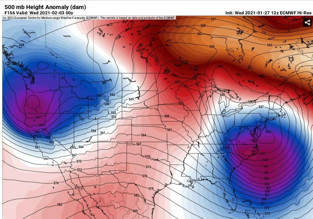
Euro was tucked at the 700 and 850. It closes off at the 500 and just meanders off the coast of NJ. Other guidance is not nearly that tucked. There is absolutely no consensus on anything ATTM. Very good hit except immediate coastal areas in NJ and very eastern LI.
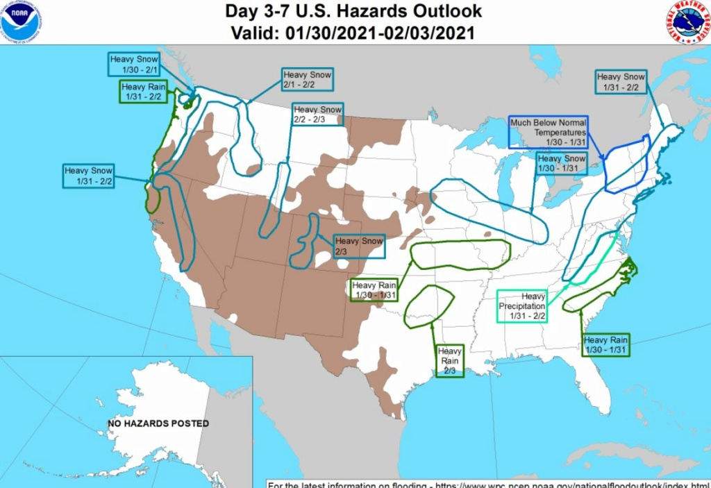
This is probably going to be a long and large scoped event. Models keep showing that theme.

This is probably going to be a long and large scoped event. Models keep showing that theme.

heehaw453- Advanced Forecaster

- Posts : 3931
Reputation : 86
Join date : 2014-01-20
Location : Bedminster Township, PA Elevation 600' ASL
 Re: Long Range Discussion 20(20) (Ha!)
Every model has a signal now. What’s the pattern dictate? If we go by the seasonal trend then I wouldn’t get my hopes up TOO MUCH for coastal areas. There’s certainly things working to our advantage this time around that have not been present in prior storms. I think those N&W of NYC should get excited, though
_________________
_______________________________________________________________________________________________________
CLICK HERE to view NJ Strong Snowstorm Classifications
heehaw453- Advanced Forecaster

- Posts : 3931
Reputation : 86
Join date : 2014-01-20
Location : Bedminster Township, PA Elevation 600' ASL
 Re: Long Range Discussion 20(20) (Ha!)
not exactly what I wanted to hear even though I am ever so slightly north of NYC it's not far enough. Well it wouldn't effect my trip plans then. I've taken the stance whatever happens happens and good luck to everyone here.Frank_Wx wrote:Every model has a signal now. What’s the pattern dictate? If we go by the seasonal trend then I wouldn’t get my hopes up TOO MUCH for coastal areas. There’s certainly things working to our advantage this time around that have not been present in prior storms. I think those N&W of NYC should get excited, though

jmanley32- Senior Enthusiast

- Posts : 20645
Reputation : 108
Join date : 2013-12-12
Age : 43
Location : Yonkers, NY
 Re: Long Range Discussion 20(20) (Ha!)
Not gonna lie, this one is making me think long and hard, and that’s just a first glance lol been a while since I posted anything because I’ve been busy. I wanted to get a post out on Sunday regarding the last event, and that clearly didn’t happen. I think I’m going to try to sit down tonight after work and really look at this and try to put together a video with my thoughts for those interested, as there are a few different things I’d like to talk about, and it’s just easier in video format.
rb924119- Meteorologist

- Posts : 7097
Reputation : 195
Join date : 2013-02-06
Age : 32
Location : Greentown, Pa
Frank_Wx, dolphins222 and jaydoy like this post
 Re: Long Range Discussion 20(20) (Ha!)
rb924119 wrote:Not gonna lie, this one is making me think long and hard, and that’s just a first glance lol been a while since I posted anything because I’ve been busy. I wanted to get a post out on Sunday regarding the last event, and that clearly didn’t happen. I think I’m going to try to sit down tonight after work and really look at this and try to put together a video with my thoughts for those interested, as there are a few different things I’d like to talk about, and it’s just easier in video format.
I'm on the edge of my seat for said motion picture!
Thoughts on possibly doing another Zoom, so that I can listen to intelligent people talk about the possibility of the next winter storm?

Irish- Pro Enthusiast

- Posts : 788
Reputation : 19
Join date : 2019-01-16
Age : 46
Location : Old Bridge, NJ
 Re: Long Range Discussion 20(20) (Ha!)
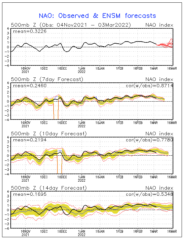
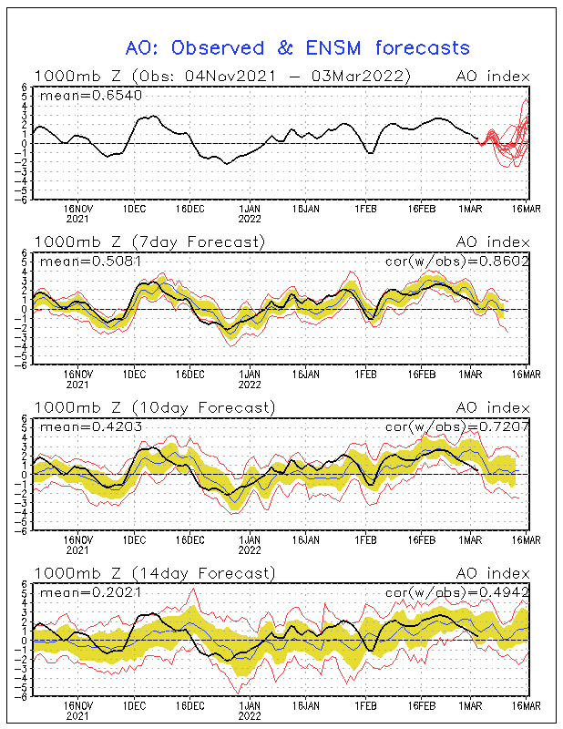
HUGE upside to this for sure - if we can get the West Coast Trough to keep moving west it will pull the Ridge with it allowing for this to deepen even further and further south. The NAO block retreating is a CLASSIC ARCHUMBALT EVENT (link: https://www.met.nps.edu/~hmarcham/bio.html).
The relaxation on the chart of teh NAO as it rises
AO
PNA spiking
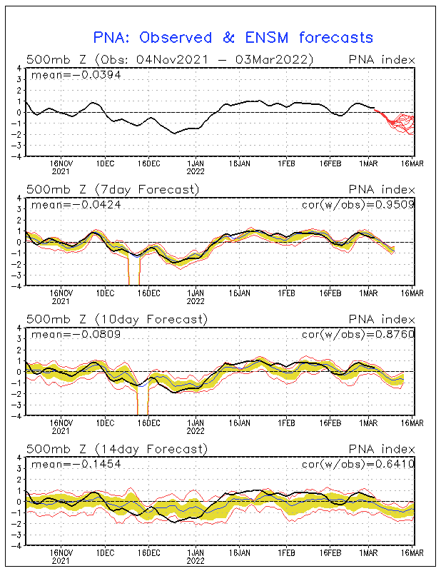
See it on these maps
EPS
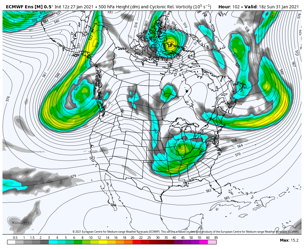
GEFS
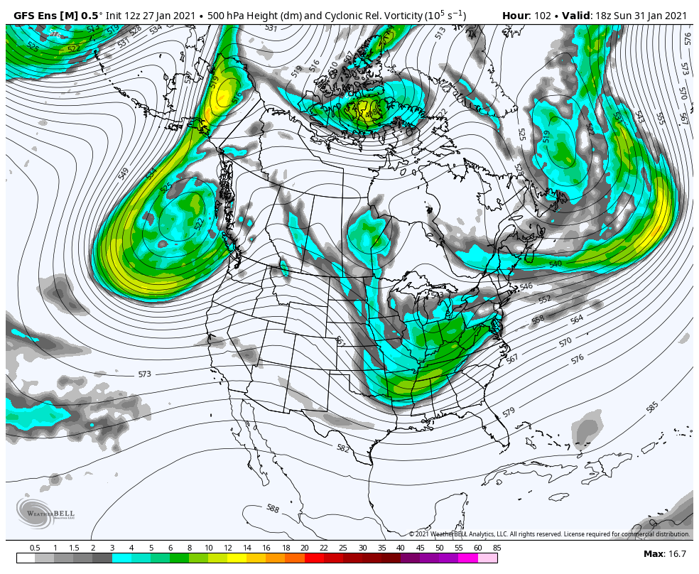
Markings aren't working sorry - if i can get it I will fix it for you.
So we have BIG upsdie potential here with lots of time,
FRANK DONT YOU DARE START A THREAD THAT SAYS MONTHRAZILLA, GODZILLA etc.- the last number of storm you have done for the board have gone in teh reverse 48/36 hours before. Just do a Storm Thread with the dates please and then when wait for it to come, deal? Deal!
For the sanity of the weather weenies do not do that to us LOL!!

The relaxation on the chart of teh NAO as it rises

AO

PNA spiking

See it on these maps
EPS

GEFS

Markings aren't working sorry - if i can get it I will fix it for you.
So we have BIG upsdie potential here with lots of time,
FRANK DONT YOU DARE START A THREAD THAT SAYS MONTHRAZILLA, GODZILLA etc.- the last number of storm you have done for the board have gone in teh reverse 48/36 hours before. Just do a Storm Thread with the dates please and then when wait for it to come, deal? Deal!
For the sanity of the weather weenies do not do that to us LOL!!

_________________
Mugs
AKA:King: Snow Weenie
Self Proclaimed
WINTER 2014-15 : 55.12" +.02 for 6 coatings (avg. 35")
WINTER 2015-16 Total - 29.8" (Avg 35")
WINTER 2016-17 : 39.5" so far

amugs- Advanced Forecaster - Mod

- Posts : 15148
Reputation : 213
Join date : 2013-01-07
Age : 54
Location : Hillsdale,NJ
 Re: Long Range Discussion 20(20) (Ha!)
HOT DOG this is bold - IF IT HOLDS!!


_________________
Mugs
AKA:King: Snow Weenie
Self Proclaimed
WINTER 2014-15 : 55.12" +.02 for 6 coatings (avg. 35")
WINTER 2015-16 Total - 29.8" (Avg 35")
WINTER 2016-17 : 39.5" so far

amugs- Advanced Forecaster - Mod

- Posts : 15148
Reputation : 213
Join date : 2013-01-07
Age : 54
Location : Hillsdale,NJ
 Re: Long Range Discussion 20(20) (Ha!)
MOMA MIA - this maybe record breaking cold with snow on the ground in teh plains from teh blizzard this week if it can ...hold. Good to see this cold building in OH CANADA


_________________
Mugs
AKA:King: Snow Weenie
Self Proclaimed
WINTER 2014-15 : 55.12" +.02 for 6 coatings (avg. 35")
WINTER 2015-16 Total - 29.8" (Avg 35")
WINTER 2016-17 : 39.5" so far

amugs- Advanced Forecaster - Mod

- Posts : 15148
Reputation : 213
Join date : 2013-01-07
Age : 54
Location : Hillsdale,NJ
 Re: Long Range Discussion 20(20) (Ha!)
Haha Al I won't do such thing!
_________________
_______________________________________________________________________________________________________
CLICK HERE to view NJ Strong Snowstorm Classifications
amugs likes this post
heehaw453- Advanced Forecaster

- Posts : 3931
Reputation : 86
Join date : 2014-01-20
Location : Bedminster Township, PA Elevation 600' ASL
 Re: Long Range Discussion 20(20) (Ha!)


Al I was thinking the same thing. Great minds....Nothing personal Frank, just a tweak to the Ju Ju
_________________
"In weather and in life, there's no winning and losing; there's only winning and learning."
WINTER 2012/2013 TOTALS 43.65"WINTER 2017/2018 TOTALS 62.85" WINTER 2022/2023 TOTALS 4.9"
WINTER 2013/2014 TOTALS 64.85"WINTER 2018/2019 TOTALS 14.25" WINTER 2023/2024 TOTALS 13.1"
WINTER 2014/2015 TOTALS 71.20"WINTER 2019/2020 TOTALS 6.35" WINTER 2024/2025 TOTALS 0.00
WINTER 2015/2016 TOTALS 35.00"WINTER 2020/2021 TOTALS 37.75"
WINTER 2016/2017 TOTALS 42.25"WINTER 2021/2022 TOTALS 31.65"

sroc4- Admin

- Posts : 8458
Reputation : 302
Join date : 2013-01-07
Location : Wading River, LI
 Re: Long Range Discussion 20(20) (Ha!)
amugs wrote:
FRANK DONT YOU DARE START A THREAD THAT SAYS MONTHRAZILLA, GODZILLA etc.- the last number of storm you have done for the board have gone in teh reverse 48/36 hours before. Just do a Storm Thread with the dates please and then when wait for it to come, deal? Deal!
For the sanity of the weather weenies do not do that to us LOL!!
Too late. Frank said "MADONNE". I was chanting Scott's "Cautious optimism" mantra out loud, but the voice in my head kept screaming "MADONNE".
So now I just tried chanting "subsidence" to try and ground myself, but that just made me nauseous


essexcountypete- Pro Enthusiast

- Posts : 783
Reputation : 12
Join date : 2013-12-09
Location : Bloomfield, NJ
CPcantmeasuresnow likes this post
 Re: Long Range Discussion 20(20) (Ha!)
Frank said Madonnne in my head I'm saying"Let's Go Crazy" will keep monitoring the breaking updates
mwilli- Posts : 132
Reputation : 3
Join date : 2019-02-11
 Re: Long Range Discussion 20(20) (Ha!)
A very 'calming' write up by Mt Holly. Seems to conjur cautious optimism. Mt Holly is usually lighting quick to discount heavy snow potential, especially for the southern half of it's coverage area- Coastal Ocean County on south. So, their lack of pessimism, with even a RARE hint of optimism, is actually solid grounds for the cautious optimism. imo...lol
LONG TERM /SATURDAY NIGHT THROUGH WEDNESDAY/...
The big story in the long term remains the low pressure system
Sunday into late Monday, which could be a classic
What has changed: No major changes with this forecast update.
Guidance came in to some better agreement with the track of the
low, but even with the minor differences, could result in
significant changes as far as impacts to our region. Thus, for
the latest forecast update, stayed close to the previous
forecast and a blend of guidance.
Timing: There are still some large differences between models
with the timing of this system. Precipitation could come in as
early as Sunday afternoon, and could linger as late as Tuesday,
depending on how progressive the system is.
Precipitation type: As mentioned above, the track will be a big
factor in the ultimate impacts for our region, especially with
regards to precipitation type. The closer the low gets to our
region, the more likely we are see wintry mix across the region.
If the track is further south, as some of the operational models
are trending, it could be more snow.
Precipitation amounts: We won`t have a better idea on
precipitation amounts through this event until at least
Saturday.
SENJsnowman- Senior Enthusiast

- Posts : 1198
Reputation : 61
Join date : 2017-01-06
Age : 51
Location : Long Branch, NJ
amugs likes this post
 Re: Long Range Discussion 20(20) (Ha!)
The 18Z GFS dumps one and a half feet of snow on LI and it's not even a consolidate nor well structured storm. LOL!
The trough depth tells me this low is probably going to be a bit more structured than what the GFS is showing. GFS is a bit lost as usual, but the main idea is long duration and potentially high impact event.
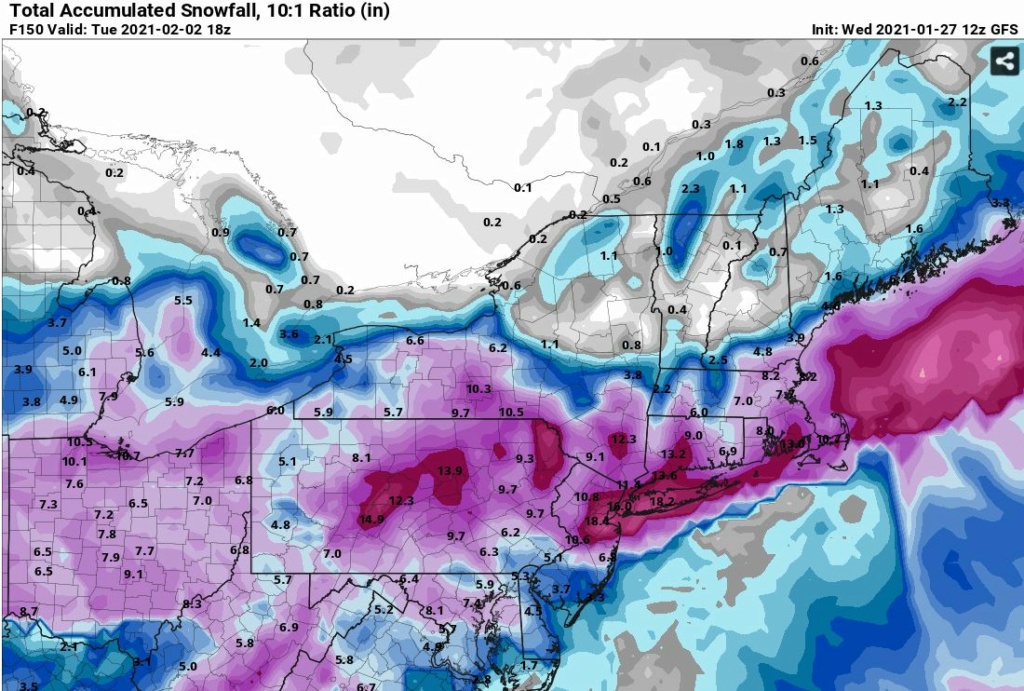
The trough depth tells me this low is probably going to be a bit more structured than what the GFS is showing. GFS is a bit lost as usual, but the main idea is long duration and potentially high impact event.

heehaw453- Advanced Forecaster

- Posts : 3931
Reputation : 86
Join date : 2014-01-20
Location : Bedminster Township, PA Elevation 600' ASL
 Re: Long Range Discussion 20(20) (Ha!)
Heeh haw - OP runs are basically turds at this point ENS as we know from tracking and H5 is where we find out some answers.
Great click bait and fun entertainment maps of course.
@ Frank Grazi Mille!!


POSITIVE JUJU!!
Great click bait and fun entertainment maps of course.
@ Frank Grazi Mille!!
POSITIVE JUJU!!
_________________
Mugs
AKA:King: Snow Weenie
Self Proclaimed
WINTER 2014-15 : 55.12" +.02 for 6 coatings (avg. 35")
WINTER 2015-16 Total - 29.8" (Avg 35")
WINTER 2016-17 : 39.5" so far

amugs- Advanced Forecaster - Mod

- Posts : 15148
Reputation : 213
Join date : 2013-01-07
Age : 54
Location : Hillsdale,NJ
 Re: Long Range Discussion 20(20) (Ha!)
Looking forward to further analysis from the best minds around (in my opinion, anyway...)


DAYBLAZER- Posts : 228
Reputation : 20
Join date : 2017-03-12
Location : Hopatcong, NJ Sussex County
 Re: Long Range Discussion 20(20) (Ha!)
amugs wrote:Heeh haw - OP runs are basically turds at this point ENS as we know from tracking and H5 is where we find out some answers.
Great click bait and fun entertainment maps of course.
@ Frank Grazi Mille!!


POSITIVE JUJU!!
LOL The H5 was a complete mess on that op run and I thought it was amazing that the model was spitting out those kinds of numbers and qpf. Can you image what it would have showed with just some consolidation? Would have been 2' +.
heehaw453- Advanced Forecaster

- Posts : 3931
Reputation : 86
Join date : 2014-01-20
Location : Bedminster Township, PA Elevation 600' ASL
 Re: Long Range Discussion 20(20) (Ha!)
New thread
_________________
_______________________________________________________________________________________________________
CLICK HERE to view NJ Strong Snowstorm Classifications
 Re: Long Range Discussion 20(20) (Ha!)
Long nights ahead coming up

Snow88- Senior Enthusiast

- Posts : 2193
Reputation : 4
Join date : 2013-01-09
Age : 36
Location : Brooklyn, NY
 Re: Long Range Discussion 20(20) (Ha!)
Snow88 wrote:Long nights ahead coming up
LOVE IT!

Irish- Pro Enthusiast

- Posts : 788
Reputation : 19
Join date : 2019-01-16
Age : 46
Location : Old Bridge, NJ
 Re: Long Range Discussion 20(20) (Ha!)
The winter-cancel forecasts for February are in danger. pic.twitter.com/Dq2LKV4wBJ
— Sam Lillo (@splillo) January 29, 2021
_________________
Mugs
AKA:King: Snow Weenie
Self Proclaimed
WINTER 2014-15 : 55.12" +.02 for 6 coatings (avg. 35")
WINTER 2015-16 Total - 29.8" (Avg 35")
WINTER 2016-17 : 39.5" so far

amugs- Advanced Forecaster - Mod

- Posts : 15148
Reputation : 213
Join date : 2013-01-07
Age : 54
Location : Hillsdale,NJ
CPcantmeasuresnow and billg315 like this post
 Re: Long Range Discussion 20(20) (Ha!)
amugs wrote:The winter-cancel forecasts for February are in danger. pic.twitter.com/Dq2LKV4wBJ
— Sam Lillo (@splillo) January 29, 2021
What does this mean?

Irish- Pro Enthusiast

- Posts : 788
Reputation : 19
Join date : 2019-01-16
Age : 46
Location : Old Bridge, NJ
 Re: Long Range Discussion 20(20) (Ha!)
Irish wrote:amugs wrote:The winter-cancel forecasts for February are in danger. pic.twitter.com/Dq2LKV4wBJ
— Sam Lillo (@splillo) January 29, 2021
What does this mean?
It means two things. First many of the long range forcasts had Feb the warmest month of the winter season flipping to a torch in fact. If what you see here comes to fruition THAT WILL NOT HAPPEN. Second, if this happen it WILL be cold and there will likely be several snow chances.

_________________
"In weather and in life, there's no winning and losing; there's only winning and learning."
WINTER 2012/2013 TOTALS 43.65"WINTER 2017/2018 TOTALS 62.85" WINTER 2022/2023 TOTALS 4.9"
WINTER 2013/2014 TOTALS 64.85"WINTER 2018/2019 TOTALS 14.25" WINTER 2023/2024 TOTALS 13.1"
WINTER 2014/2015 TOTALS 71.20"WINTER 2019/2020 TOTALS 6.35" WINTER 2024/2025 TOTALS 0.00
WINTER 2015/2016 TOTALS 35.00"WINTER 2020/2021 TOTALS 37.75"
WINTER 2016/2017 TOTALS 42.25"WINTER 2021/2022 TOTALS 31.65"

sroc4- Admin

- Posts : 8458
Reputation : 302
Join date : 2013-01-07
Location : Wading River, LI
jmanley32, heehaw453, GreyBeard, billg315, SENJsnowman and Irish like this post
Page 29 of 30 •  1 ... 16 ... 28, 29, 30
Page 29 of 30
Permissions in this forum:
You cannot reply to topics in this forum
 Home
Home

