Long Range Discussion 20(20) (Ha!)
+43
toople
TheAresian
Koroptim
Bkdude
essexcountypete
chief7
GreyBeard
crippo84
hyde345
lglickman1
Zhukov1945
bloc1357
SENJsnowman
Snow88
CPcantmeasuresnow
bobjohnsonforthehall
weatherwatchermom
skinsfan1177
billg315
SoulSingMG
phil155
aiannone
nutleyblizzard
Math23x7
Wheezer
Irish
Frank_Wx
mwilli
Grselig
Isotherm
heehaw453
jimv45
frank 638
docstox12
rb924119
sroc4
HectorO
algae888
dkodgis
Radz
jmanley32
amugs
Dunnzoo
47 posters
Page 28 of 30
Page 28 of 30 •  1 ... 15 ... 27, 28, 29, 30
 Re: Long Range Discussion 20(20) (Ha!)
SROC LOL!!!! 
amugs- Advanced Forecaster - Mod

- Posts : 15157
Join date : 2013-01-07
 Re: Long Range Discussion 20(20) (Ha!)
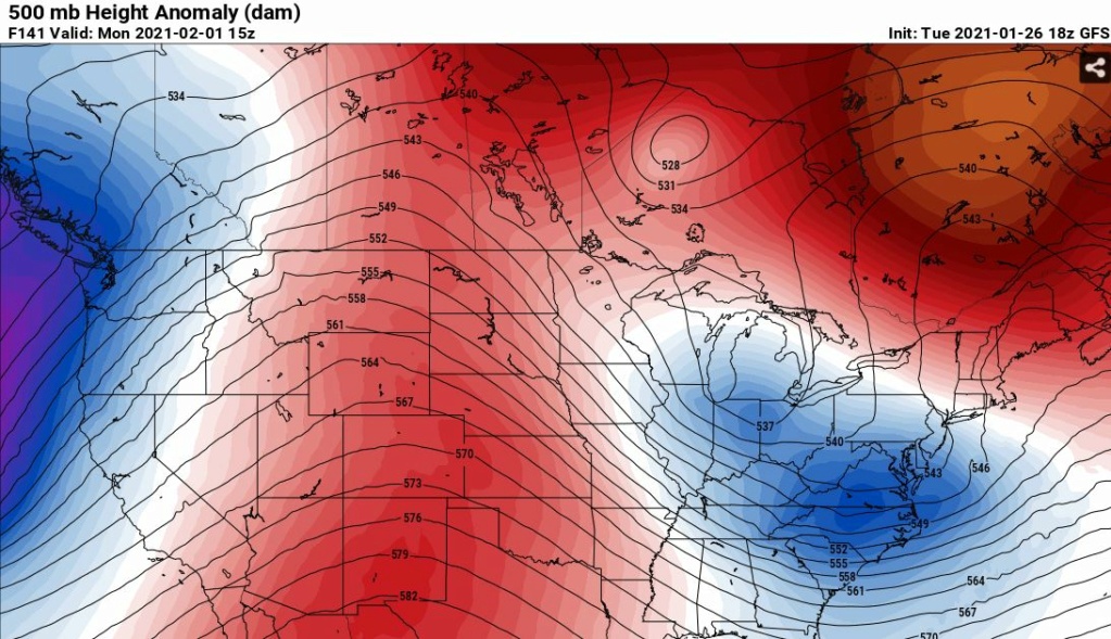
Look at the tilt of the trough on this latest GFS. That kind of tilt is basically throwing a bucket of water over the land mass after it's been filled up in the Atlantic. Big storm as shown and GFS is coming around to that. And no I'm not paying one bit of attention to GFS thermal profiles right now. I'm just trying to see what it's doing at the 500 mb.
What you are seeing is uncanny model agreement on a major EC storm at D5+. Details obviously are not known...
18Z GFS
What you are seeing is uncanny model agreement on a major EC storm at D5+. Details obviously are not known...
18Z GFS

heehaw453- Advanced Forecaster

- Posts : 3942
Join date : 2014-01-20
 Re: Long Range Discussion 20(20) (Ha!)
heehaw453 wrote:Look at the tilt of the trough on this latest GFS. That kind of tilt is basically throwing a bucket of water over the land mass after it's been filled up in the Atlantic. Big storm as shown and GFS is coming around to that. And no I'm not paying one bit of attention to GFS thermal profiles right now. I'm just trying to see what it's doing at the 500 mb.
What you are seeing is uncanny model agreement on a major EC storm at D5+. Details obviously are not known...
18Z GFS
It has some similarities to the storm we saw in December. I’m going to take a closer look at this one tomorrow. Not a bad spot to be in right now
_________________
_______________________________________________________________________________________________________
CLICK HERE to view NJ Strong Snowstorm Classifications
 Re: Long Range Discussion 20(20) (Ha!)
Pretty impressive signal for 5 days out but the ultimate phase of the storm to me looks sloppy. Even so we end up with a general 6-12. If we can get a bit more robust ridge and or sharper trough we would get a cleaner phase and a crawling sub 970 beast on our hands. Something to look for in future runs.heehaw453 wrote:Look at the tilt of the trough on this latest GFS. That kind of tilt is basically throwing a bucket of water over the land mass after it's been filled up in the Atlantic. Big storm as shown and GFS is coming around to that. And no I'm not paying one bit of attention to GFS thermal profiles right now. I'm just trying to see what it's doing at the 500 mb.
What you are seeing is uncanny model agreement on a major EC storm at D5+. Details obviously are not known...
18Z GFS

nutleyblizzard- Senior Enthusiast

- Posts : 1964
Reputation : 41
Join date : 2014-01-30
Age : 58
Location : Nutley, new jersey
 Re: Long Range Discussion 20(20) (Ha!)
Calling rb, what are your thoughts for the possibility of a storm Sunday- Tuesday?

Irish- Pro Enthusiast

- Posts : 788
Reputation : 19
Join date : 2019-01-16
Age : 46
Location : Old Bridge, NJ
 Re: Long Range Discussion 20(20) (Ha!)
Can't wait to see more expert analysis on this latest snow chance. I'm just curious. I see everyone posting about the GFS maps and runs that are pointing to the potential of this storm. The way the GFS has performed lately, is it best to wait to see what the Euro and other models show. Just wondering as a beginner.
Fededle22- Posts : 169
Reputation : 2
Join date : 2013-03-08
Location : West Orange, NJ
 Re: Long Range Discussion 20(20) (Ha!)
The storm that we're all discussing that looks to impact us early next week has been named Winter Storm Orlena.

Irish- Pro Enthusiast

- Posts : 788
Reputation : 19
Join date : 2019-01-16
Age : 46
Location : Old Bridge, NJ
 Re: Long Range Discussion 20(20) (Ha!)
_________________
_______________________________________________________________________________________________________
CLICK HERE to view NJ Strong Snowstorm Classifications
 Re: Long Range Discussion 20(20) (Ha!)
Fingers crossed as this season has underperformed so far. The Dec storm was a decent storm, but we need more, my little one has a sled she is dying to use at least once more. Bring us the goods Mother Nature!!!!!
jaydoy- Posts : 23
Reputation : 1
Join date : 2019-01-23
 Re: Long Range Discussion 20(20) (Ha!)
TWC has upped accumulation projections for my area from 6-12 to 7-15 for Orlena. Not too much different but going in a better direction. Hope it continues.

Irish- Pro Enthusiast

- Posts : 788
Reputation : 19
Join date : 2019-01-16
Age : 46
Location : Old Bridge, NJ
 Re: Long Range Discussion 20(20) (Ha!)
Guidance is showing a long drawn out event with a ULL that closes off. When ULL closes off all bets are off to what happens. Yes the latest Euro Op sheered the ULL and it fell apart, but the ensembles EPS fully supports a coastal crawler.
Where does the ULL close off, how quickly it forms, how close it gets to the coast, how strong it gets we just don't have any of those details. Folks from VA to ME are in the threat area ATTM.
Frank's point is valid that we need to get to Friday before there is any confidence of a MAJOR threat here.
heehaw453- Advanced Forecaster

- Posts : 3942
Reputation : 86
Join date : 2014-01-20
Location : Bedminster Township, PA Elevation 600' ASL
 Re: Long Range Discussion 20(20) (Ha!)
One thing I’ve noticed is how our last couple of storms and the upcoming one all had a transfer to the coast. The problem being these transfers are happening far too late and with not enough cold air. When the -NAO acts alone without support from the Pacific, you get these nickel and dime events that models can’t get right until inside 48 hours.
_________________
_______________________________________________________________________________________________________
CLICK HERE to view NJ Strong Snowstorm Classifications
 Re: Long Range Discussion 20(20) (Ha!)
Frank_Wx wrote:One thing I’ve noticed is how our last couple of storms and the upcoming one all had a transfer to the coast. The problem being these transfers are happening far too late and with not enough cold air. When the -NAO acts alone without support from the Pacific, you get these nickel and dime events that models can’t get right until inside 48 hours.
Agreed. I think an important aspect is if the ULL energy closing off before hitting the coast. If it does, then it'll probably catch up to the surface and 850/700 and vertically stack. At that point it's probably a coastal crawler right up to the Canadian Maritimes. If not and the ULL is ragged and disjointed from the other layers then it's going to be a modest to maybe moderate event IMO. With the PNA going + in conjunction with a good antecedent air mass it gives us a fighting chance. Fun to track at least!
heehaw453- Advanced Forecaster

- Posts : 3942
Reputation : 86
Join date : 2014-01-20
Location : Bedminster Township, PA Elevation 600' ASL
 Re: Long Range Discussion 20(20) (Ha!)
Eps is a long duration storm. Further north than the 0z euro op.

Snow88- Senior Enthusiast

- Posts : 2193
Reputation : 4
Join date : 2013-01-09
Age : 36
Location : Brooklyn, NY
 Re: Long Range Discussion 20(20) (Ha!)
heehaw453 wrote:Frank_Wx wrote:One thing I’ve noticed is how our last couple of storms and the upcoming one all had a transfer to the coast. The problem being these transfers are happening far too late and with not enough cold air. When the -NAO acts alone without support from the Pacific, you get these nickel and dime events that models can’t get right until inside 48 hours.
Agreed. I think an important aspect is if the ULL energy closing off before hitting the coast. If it does, then it'll probably catch up to the surface and 850/700 and vertically stack. At that point it's probably a coastal crawler right up to the Canadian Maritimes. If not and the ULL is ragged and disjointed from the other layers then it's going to be a modest to maybe moderate event IMO. With the PNA going + in conjunction with a good antecedent air mass it gives us a fighting chance. Fun to track at least!
The spacing between the system that will pass to our south tomorrow and this threat is much better. It at least allows room for our heights to increase out in front. That was a major detriment to tomorrow’s system. The system that passed overnight and tomorrow’s system were too close. As last nights system amplifies off the coast it’s close proximity to the next one combined with some of the other factors I prev outlined to the north, didn’t allow heights to raise along the coast for tomorrow’s system to come up. Regarding The system that happened yesterday and overnight the main issue in preventing a more wide spread light to moderate event for our coverage area was like Frank said zero cooperation with the PAC. Such a flat flow from the PAC jet killed us. But heehaw like you said while I wouldn’t exactly call it a true +PNa the strength of the strong negative PNA is relaxing towards a more neutral state making it “more positive” relatively speaking. Same with the EPO. While it won’t be truly negative it too is relaxing towards a neutral state “more negative” relatively speaking. NAO still negative but also relaxing a bit.
With the space out in front of this system I think an overly amped system and a closed500mb low that gets too far N&W is also something to concern ourselves with as much as a closing off too late again. Esp because the NAO region is relaxing.
The trend seems to be That the main energy seems to be under modeled in the medium range. Hopefully there’s enough relaxation in the PNA and EPO regions, and still enough resistance in the NAO and AO regions that we achieve baby bear, or at least close to it and not an overly amped system that cuts where the majority of us get the slop again.
_________________
"In weather and in life, there's no winning and losing; there's only winning and learning."
WINTER 2012/2013 TOTALS 43.65"WINTER 2017/2018 TOTALS 62.85" WINTER 2022/2023 TOTALS 4.9"
WINTER 2013/2014 TOTALS 64.85"WINTER 2018/2019 TOTALS 14.25" WINTER 2023/2024 TOTALS 13.1"
WINTER 2014/2015 TOTALS 71.20"WINTER 2019/2020 TOTALS 6.35" WINTER 2024/2025 TOTALS 0.00
WINTER 2015/2016 TOTALS 35.00"WINTER 2020/2021 TOTALS 37.75"
WINTER 2016/2017 TOTALS 42.25"WINTER 2021/2022 TOTALS 31.65"

sroc4- Admin

- Posts : 8461
Reputation : 302
Join date : 2013-01-07
Location : Wading River, LI

CPcantmeasuresnow- Wx Statistician Guru

- Posts : 7288
Reputation : 230
Join date : 2013-01-07
Age : 103
Location : Eastern Orange County, NY
 Re: Long Range Discussion 20(20) (Ha!)
sroc4 wrote:heehaw453 wrote:Frank_Wx wrote:One thing I’ve noticed is how our last couple of storms and the upcoming one all had a transfer to the coast. The problem being these transfers are happening far too late and with not enough cold air. When the -NAO acts alone without support from the Pacific, you get these nickel and dime events that models can’t get right until inside 48 hours.
Agreed. I think an important aspect is if the ULL energy closing off before hitting the coast. If it does, then it'll probably catch up to the surface and 850/700 and vertically stack. At that point it's probably a coastal crawler right up to the Canadian Maritimes. If not and the ULL is ragged and disjointed from the other layers then it's going to be a modest to maybe moderate event IMO. With the PNA going + in conjunction with a good antecedent air mass it gives us a fighting chance. Fun to track at least!
The spacing between the system that will pass to our south tomorrow and this threat is much better. It at least allows room for our heights to increase out in front. That was a major detriment to tomorrow’s system. The system that passed overnight and tomorrow’s system were too close. As last nights system amplifies off the coast it’s close proximity to the next one combined with some of the other factors I prev outlined to the north, didn’t allow heights to raise along the coast for tomorrow’s system to come up. Regarding The system that happened yesterday and overnight the main issue in preventing a more wide spread light to moderate event for our coverage area was like Frank said zero cooperation with the PAC. Such a flat flow from the PAC jet killed us. But heehaw like you said while I wouldn’t exactly call it a true +PNa the strength of the strong negative PNA is relaxing towards a more neutral state making it “more positive” relatively speaking. Same with the EPO. While it won’t be truly negative it too is relaxing towards a neutral state “more negative” relatively speaking. NAO still negative but also relaxing a bit.
With the space out in front of this system I think an overly amped system and a closed500mb low that gets too far N&W is also something to concern ourselves with as much as a closing off too late again. Esp because the NAO region is relaxing.
The trend seems to be That the main energy seems to be under modeled in the medium range. Hopefully there’s enough relaxation in the PNA and EPO regions, and still enough resistance in the NAO and AO regions that we achieve baby bear, or at least close to it and not an overly amped system that cuts where the majority of us get the slop again.
The western ridge axis is too far east, but our saving grace is the blocking which aids in slowing things down and keeping the low near the coast.

H5 closes off at JUST the right time. These intricacies at the surface won't be well-modeled for days to come, unfortunately. Pay attention to the ensembles and see what they're trying to do. EPS looked great last night.
_________________
_______________________________________________________________________________________________________
CLICK HERE to view NJ Strong Snowstorm Classifications
 Re: Long Range Discussion 20(20) (Ha!)
_________________
_______________________________________________________________________________________________________
CLICK HERE to view NJ Strong Snowstorm Classifications
 Re: Long Range Discussion 20(20) (Ha!)
My observation on that run is I want to see the ULL slide underneath us around Ocean City MD. I don't care for where the GFS has it placed.
heehaw453- Advanced Forecaster

- Posts : 3942
Reputation : 86
Join date : 2014-01-20
Location : Bedminster Township, PA Elevation 600' ASL
 Re: Long Range Discussion 20(20) (Ha!)
heehaw453 wrote:
My observation on that run is I want to see the ULL slide underneath us around Ocean City MD. I don't care for where the GFS has it placed.
Going to need to watch the behavior of the h7 AND h8 closed lows as well to determine where the heaviest axis of snowfall will fall and how and where the temp profiles behave. Again a concerning trend has been as we enter inside the 72-96 hr window to have our southern system trend more amped sending these features over or slightly N&W of us shifting the snow axis N&W. My typical phrase of Cautious optimism couldn't be more prudent here.


_________________
"In weather and in life, there's no winning and losing; there's only winning and learning."
WINTER 2012/2013 TOTALS 43.65"WINTER 2017/2018 TOTALS 62.85" WINTER 2022/2023 TOTALS 4.9"
WINTER 2013/2014 TOTALS 64.85"WINTER 2018/2019 TOTALS 14.25" WINTER 2023/2024 TOTALS 13.1"
WINTER 2014/2015 TOTALS 71.20"WINTER 2019/2020 TOTALS 6.35" WINTER 2024/2025 TOTALS 0.00
WINTER 2015/2016 TOTALS 35.00"WINTER 2020/2021 TOTALS 37.75"
WINTER 2016/2017 TOTALS 42.25"WINTER 2021/2022 TOTALS 31.65"

sroc4- Admin

- Posts : 8461
Reputation : 302
Join date : 2013-01-07
Location : Wading River, LI
 Re: Long Range Discussion 20(20) (Ha!)
sroc4 wrote:heehaw453 wrote:
My observation on that run is I want to see the ULL slide underneath us around Ocean City MD. I don't care for where the GFS has it placed.
Going to need to watch the behavior of the h7 AND h8 closed lows as well to determine where the heaviest axis of snowfall will fall and how and where the temp profiles behave. Again a concerning trend has been as we enter inside the 72-96 hr window to have our southern system trend more amped sending these features over or slightly N&W of us shifting the snow axis N&W. My typical phrase of Cautious optimism couldn't be more prudent here.
Agree 100%. The usual rules apply here. Mixing issues and subsidence. Those that get hit though are going to get a nice one IMO. See what Euro says in a bit, but the suppression scenario is gaining less traction.
heehaw453- Advanced Forecaster

- Posts : 3942
Reputation : 86
Join date : 2014-01-20
Location : Bedminster Township, PA Elevation 600' ASL
 Re: Long Range Discussion 20(20) (Ha!)
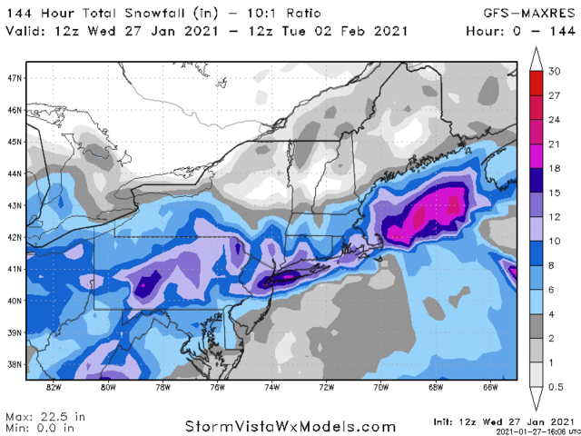
Ya don't see it too often that NYC and pts south to LI see the highest totals LOLsroc4 wrote:heehaw453 wrote:
My observation on that run is I want to see the ULL slide underneath us around Ocean City MD. I don't care for where the GFS has it placed.
Going to need to watch the behavior of the h7 AND h8 closed lows as well to determine where the heaviest axis of snowfall will fall and how and where the temp profiles behave. Again a concerning trend has been as we enter inside the 72-96 hr window to have our southern system trend more amped sending these features over or slightly N&W of us shifting the snow axis N&W. My typical phrase of Cautious optimism couldn't be more prudent here.

jmanley32- Senior Enthusiast

- Posts : 20648
Reputation : 108
Join date : 2013-12-12
Age : 43
Location : Yonkers, NY
 Re: Long Range Discussion 20(20) (Ha!)
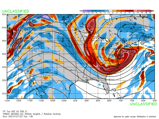
The 12z NAVGEM just went Godzilla on us
_________________
_______________________________________________________________________________________________________
CLICK HERE to view NJ Strong Snowstorm Classifications
weatherwatchermom likes this post
 Re: Long Range Discussion 20(20) (Ha!)
_________________
_______________________________________________________________________________________________________
CLICK HERE to view NJ Strong Snowstorm Classifications
 Re: Long Range Discussion 20(20) (Ha!)
No Model hugging- I promise. No Weenie snow maps on this post, they belong in banter. 

But, oh! Today's 12z CMC is a coastie delight! Look at that bowling ball rounding the bend! Look at all that cold air at the lower levels. Get outta there 850 warm nose- stay in Philly!
My question: Is this scenario on the table with the same level of probability as the GFS solution at this time? Oh, and has the Canadian model been reliable at all? ( I think not, actually. )
)
And ok, one weenie map at the end.
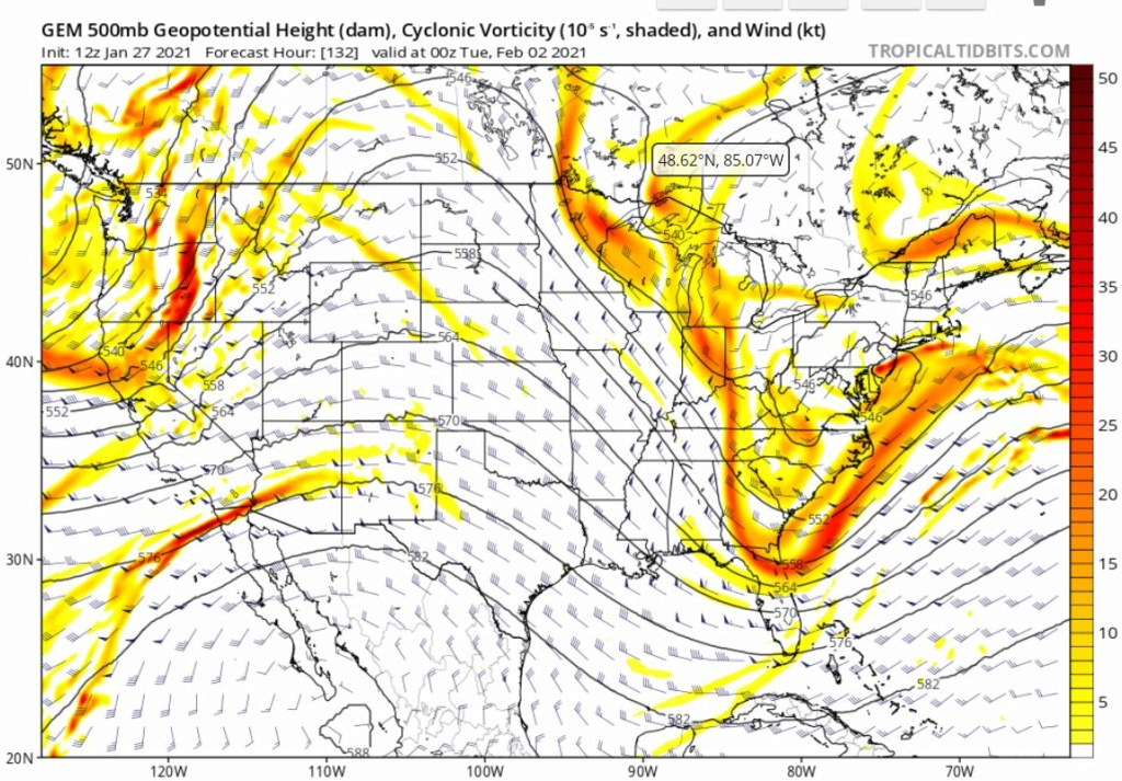

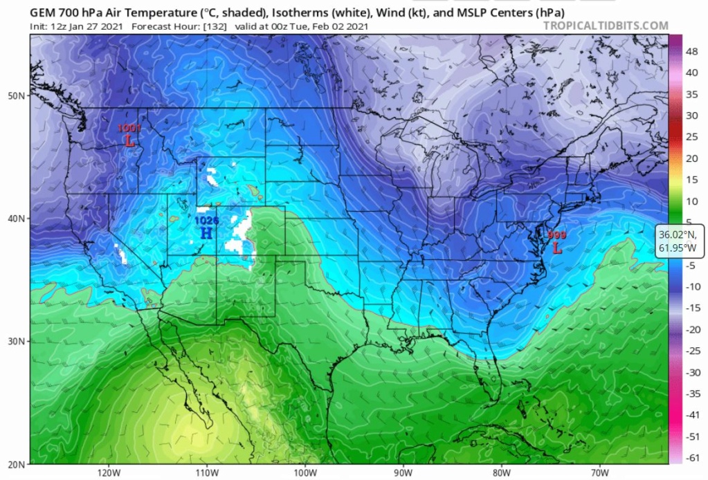

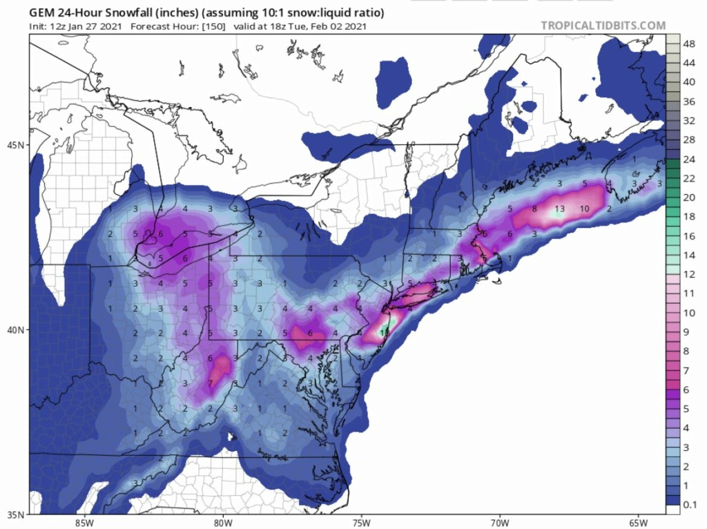
But, oh! Today's 12z CMC is a coastie delight! Look at that bowling ball rounding the bend! Look at all that cold air at the lower levels. Get outta there 850 warm nose- stay in Philly!
My question: Is this scenario on the table with the same level of probability as the GFS solution at this time? Oh, and has the Canadian model been reliable at all? ( I think not, actually.
And ok, one weenie map at the end.


SENJsnowman- Senior Enthusiast

- Posts : 1202
Reputation : 61
Join date : 2017-01-06
Age : 51
Location : Long Branch, NJ
 Re: Long Range Discussion 20(20) (Ha!)
_________________
-Alex Iannone-

aiannone- Senior Enthusiast - Mod

- Posts : 4828
Reputation : 92
Join date : 2013-01-07
Location : Saint James, LI (Northwest Suffolk Co.)

aiannone- Senior Enthusiast - Mod

- Posts : 4828
Reputation : 92
Join date : 2013-01-07
Location : Saint James, LI (Northwest Suffolk Co.)
Page 28 of 30 •  1 ... 15 ... 27, 28, 29, 30
Page 28 of 30
Permissions in this forum:
You cannot reply to topics in this forum
 Home
Home

