Long Range Discussion 22.0
Page 23 of 31 •  1 ... 13 ... 22, 23, 24 ... 27 ... 31
 Re: Long Range Discussion 22.0
Frank - Great post regarding storm threats. I’ve not paid attention to the 27th-29th, but I’ll take your word for it
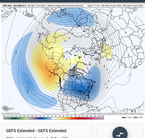
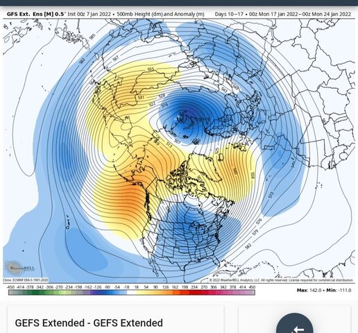
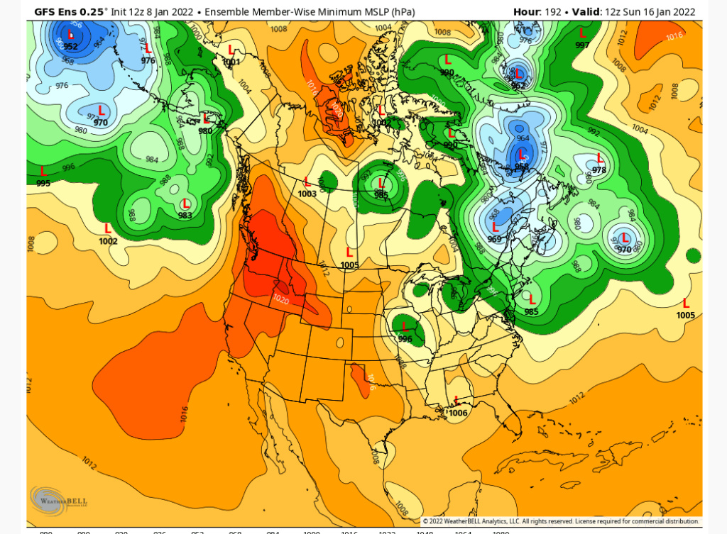
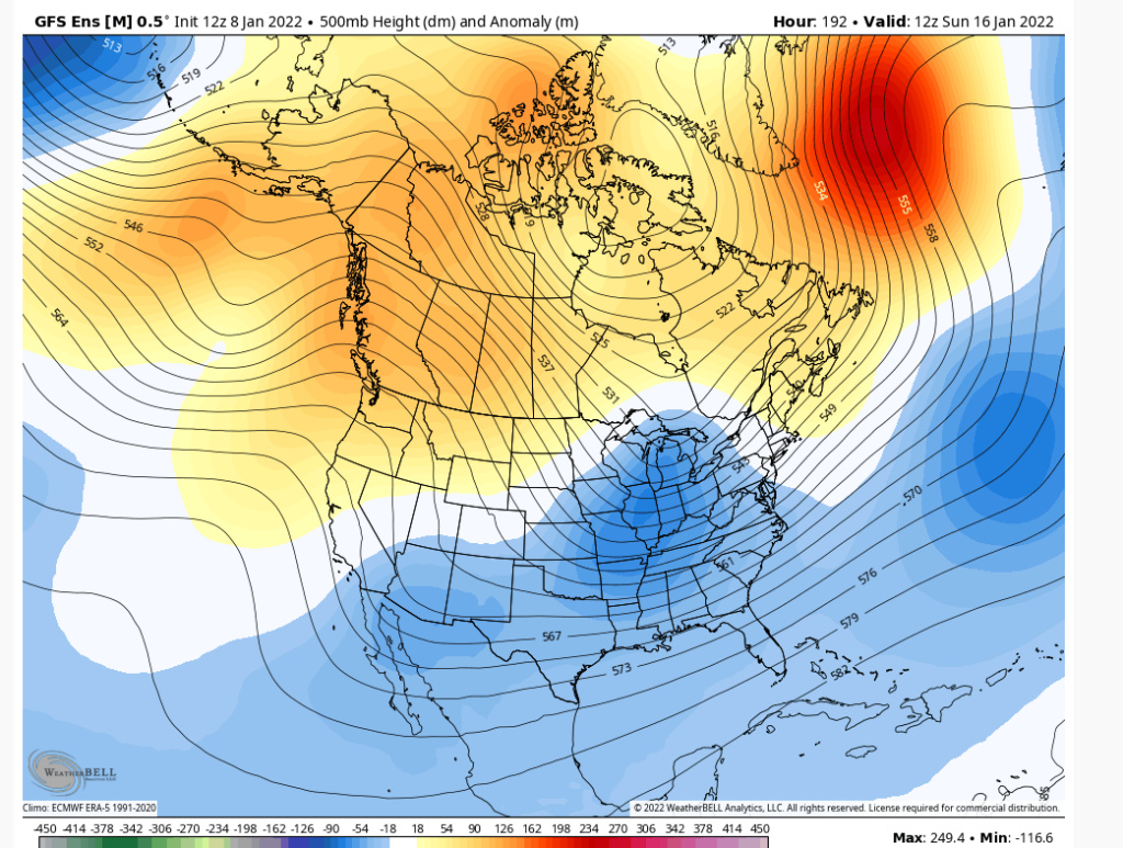
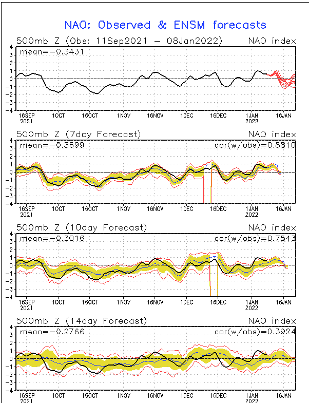
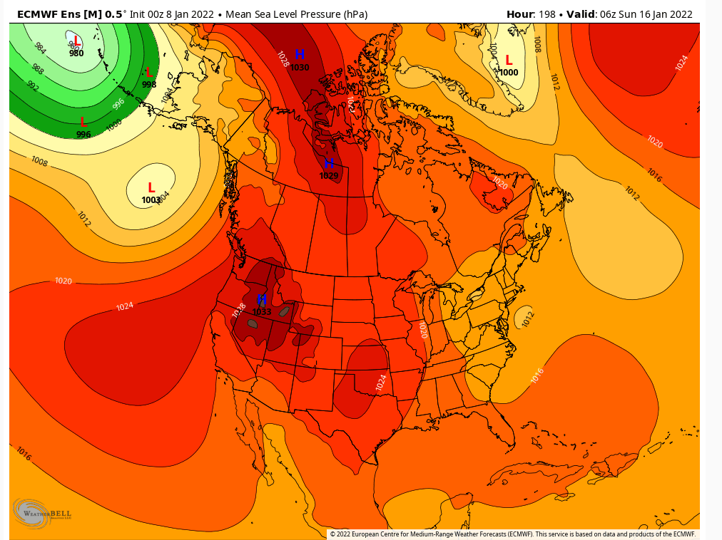
Heehaw - I don’t think there’s any question of whether or not we CAN do it. The potential in the pattern is there. The question is whether or not that potential will be realized. There are some interesting goings on for the 13th-16th threat regarding the evolution, and I’m probably going to do a video discussion either tomorrow (really today at this point lol) or Sunday highlighting exactly what I mean. But basically, you have a juxtaposition of a decaying progressive pattern within a larger retrograding pattern that’s reaching the end of its retrogression. Now, to me, my preliminary excitement for this particular period still appears to be warranted BIGLY based on two things: 1) pattern recognition and 2) looking at the intricacies of the ensembles and how they should eventually evolve as we start getting inside Day 4-5. And yes, I do think it will take that long before we “see” the threat really showing up on guidance. And based on preliminary analysis, I don’t think we will be talking about another 5-10 incher. I don’t want to hype too much, but I think the potential ceiling is VERY MUCH HIGHER than that. And that’s just system 1. We are entering a pattern that is not dissimilar from the pattern that produced Snowmageddon, in my opinion.
rb924119- Meteorologist

- Posts : 7040
Join date : 2013-02-06
amugs, chief7, SENJsnowman and Irish like this post
 Re: Long Range Discussion 22.0
chief7- Posts : 132
Join date : 2013-11-10
 Re: Long Range Discussion 22.0

Snow88- Senior Enthusiast

- Posts : 2193
Reputation : 4
Join date : 2013-01-09
Age : 36
Location : Brooklyn, NY
chief7 likes this post
 Re: Long Range Discussion 22.0
Snow88 wrote:Explosive pattern ahead
Let's hope so long range looks good

skinsfan1177- Senior Enthusiast

- Posts : 4485
Reputation : 35
Join date : 2013-01-07
Age : 47
Location : Point Pleasant Boro
chief7 likes this post
 Re: Long Range Discussion 22.0
heehaw453- Advanced Forecaster

- Posts : 3914
Reputation : 86
Join date : 2014-01-20
Location : Bedminster Township, PA Elevation 600' ASL
chief7 and Irish like this post
 Re: Long Range Discussion 22.0
_________________
_______________________________________________________________________________________________________
CLICK HERE to view NJ Strong Snowstorm Classifications
rb924119, chief7 and Bwtr like this post
 Re: Long Range Discussion 22.0
In regard to weather or are you going on a trip to Mexico and intend on drinking the water?Snow88 wrote:Explosive pattern ahead

Irish- Pro Enthusiast

- Posts : 788
Reputation : 19
Join date : 2019-01-16
Age : 46
Location : Old Bridge, NJ
Grselig likes this post
 Re: Long Range Discussion 22.0
Irish wrote:In regard to weather or are you going on a trip to Mexico and intend on drinking the water?Snow88 wrote:Explosive pattern ahead


I literally spit coffee out reading that.
_________________
"In weather and in life, there's no winning and losing; there's only winning and learning."
WINTER 2012/2013 TOTALS 43.65"WINTER 2017/2018 TOTALS 62.85" WINTER 2022/2023 TOTALS 4.9"
WINTER 2013/2014 TOTALS 64.85"WINTER 2018/2019 TOTALS 14.25" WINTER 2023/2024 TOTALS 13.1"
WINTER 2014/2015 TOTALS 71.20"WINTER 2019/2020 TOTALS 6.35"
WINTER 2015/2016 TOTALS 35.00"WINTER 2020/2021 TOTALS 37.75"
WINTER 2016/2017 TOTALS 42.25"WINTER 2021/2022 TOTALS 31.65"

sroc4- Admin

- Posts : 8446
Reputation : 302
Join date : 2013-01-07
Location : Wading River, LI
Grselig and Irish like this post
rb924119- Meteorologist

- Posts : 7040
Reputation : 195
Join date : 2013-02-06
Age : 32
Location : Greentown, Pa
 Re: Long Range Discussion 22.0
rb924119- Meteorologist

- Posts : 7040
Reputation : 195
Join date : 2013-02-06
Age : 32
Location : Greentown, Pa
heehaw453- Advanced Forecaster

- Posts : 3914
Reputation : 86
Join date : 2014-01-20
Location : Bedminster Township, PA Elevation 600' ASL
rb924119, billg315, Irish and Bwtr like this post
heehaw453- Advanced Forecaster

- Posts : 3914
Reputation : 86
Join date : 2014-01-20
Location : Bedminster Township, PA Elevation 600' ASL
rb924119 likes this post
 Re: Long Range Discussion 22.0
rb924119- Meteorologist

- Posts : 7040
Reputation : 195
Join date : 2013-02-06
Age : 32
Location : Greentown, Pa
MattyICE- Advanced Forecaster

- Posts : 249
Reputation : 6
Join date : 2017-11-10
Age : 39
Location : Clifton, NJ (Eastern Passaic County)
rb924119- Meteorologist

- Posts : 7040
Reputation : 195
Join date : 2013-02-06
Age : 32
Location : Greentown, Pa
MattyICE likes this post
 Re: Long Range Discussion 22.0
rb924119- Meteorologist

- Posts : 7040
Reputation : 195
Join date : 2013-02-06
Age : 32
Location : Greentown, Pa
amugs likes this post
 Re: Long Range Discussion 22.0
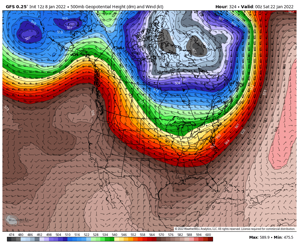
EPO/PNA COUPLET WITH PV OVWR HUDSON BAY IS JUST DELICIOUS!
_________________
Mugs
AKA:King: Snow Weenie
Self Proclaimed
WINTER 2014-15 : 55.12" +.02 for 6 coatings (avg. 35")
WINTER 2015-16 Total - 29.8" (Avg 35")
WINTER 2016-17 : 39.5" so far

amugs- Advanced Forecaster - Mod

- Posts : 15130
Reputation : 213
Join date : 2013-01-07
Age : 54
Location : Hillsdale,NJ
rb924119 and weatherwatchermom like this post
 Re: Long Range Discussion 22.0
From Jim Sullivan Pro Met
After struggling mightily with the Pacific pattern through December...WOOF...extended jet resulting in a milder spell next week retracts and settles into a configuration allowing for an Aleutian low/West Coast ridge. Some sub-tropical jet too. Second half of January looks wintry. pic.twitter.com/kQFfSZaoy3
— Jim Sullivan (@JimSullivan92) January 8, 2022
_________________
Mugs
AKA:King: Snow Weenie
Self Proclaimed
WINTER 2014-15 : 55.12" +.02 for 6 coatings (avg. 35")
WINTER 2015-16 Total - 29.8" (Avg 35")
WINTER 2016-17 : 39.5" so far

amugs- Advanced Forecaster - Mod

- Posts : 15130
Reputation : 213
Join date : 2013-01-07
Age : 54
Location : Hillsdale,NJ
rb924119 likes this post
 Re: Long Range Discussion 22.0
Rb said in his video from early December, “you might have to wait as far into Jan as Week 3…” And just look at what’s out there, right on cue! Amazing.
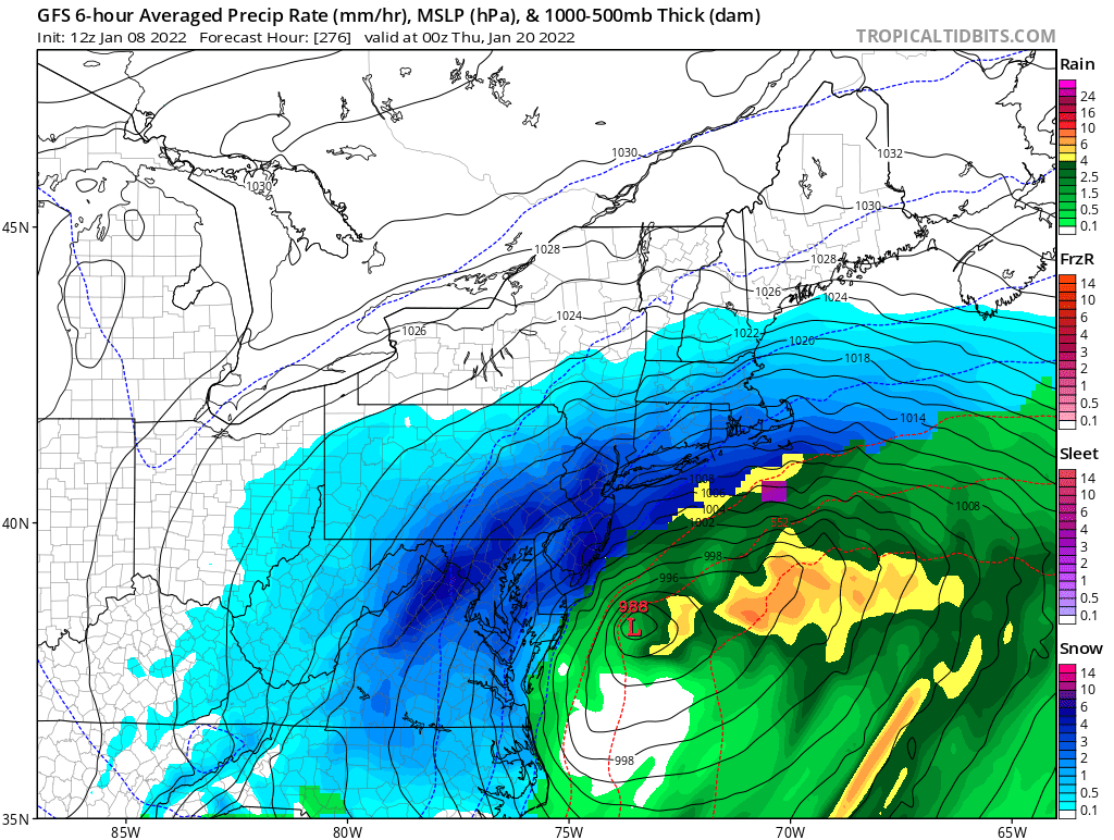
This snow map showed over a foot for every single member of the board. It’s quite literally one of the biggest ‘clown maps’ you’ll ever see.
SENJsnowman- Senior Enthusiast

- Posts : 1197
Reputation : 61
Join date : 2017-01-06
Age : 51
Location : Long Branch, NJ
rb924119 likes this post
 Re: Long Range Discussion 22.0
SENJsnowman wrote:
Rb said in his video from early December, “you might have to wait as far into Jan as Week 3…” And just look at what’s out there, right on cue! Amazing.
This snow map showed over a foot for every single member of the board. It’s quite literally one of the biggest ‘clown maps’ you’ll ever see.
Right. Totally aware. That’s why I said “I know I know…” etc!
MattyICE- Advanced Forecaster

- Posts : 249
Reputation : 6
Join date : 2017-11-10
Age : 39
Location : Clifton, NJ (Eastern Passaic County)
rb924119 and SENJsnowman like this post
 Re: Long Range Discussion 22.0
MattyICE wrote:SENJsnowman wrote:
Rb said in his video from early December, “you might have to wait as far into Jan as Week 3…” And just look at what’s out there, right on cue! Amazing.
This snow map showed over a foot for every single member of the board. It’s quite literally one of the biggest ‘clown maps’ you’ll ever see.
Right. Totally aware. That’s why I said “I know I know…” etc!
I wasn’t suspecting you of clowning Matty. Was just pointing the surreal nature of the potential that’s being teased out. Sorry for the confusion.
SENJsnowman- Senior Enthusiast

- Posts : 1197
Reputation : 61
Join date : 2017-01-06
Age : 51
Location : Long Branch, NJ
MattyICE likes this post
 Re: Long Range Discussion 22.0
SENJsnowman wrote:
Rb said in his video from early December, “you might have to wait as far into Jan as Week 3…” And just look at what’s out there, right on cue! Amazing.
This snow map showed over a foot for every single member of the board. It’s quite literally one of the biggest ‘clown maps’ you’ll ever see.
This is nothing compared to the EURO Control run from today. Multiply this by three over a nine-day span, and it keeps going lol the thing is, that WILL BE the result IF the maximum potential is realized here with this upcoming pattern. Not saying it’s definite, but that’s what the ceiling is of this pattern.
Now, regarding the 13th-16th, I’m doing some preliminary analysis, and I think I like what I’m seeing so far, but it is a highly delicate setup; more than usual. So there are a lot of ways it can go wrong, but from what I’m seeing right now, I still like the threat.
rb924119- Meteorologist

- Posts : 7040
Reputation : 195
Join date : 2013-02-06
Age : 32
Location : Greentown, Pa
SENJsnowman likes this post
 Re: Long Range Discussion 22.0
SENJsnowman- Senior Enthusiast

- Posts : 1197
Reputation : 61
Join date : 2017-01-06
Age : 51
Location : Long Branch, NJ
 Re: Long Range Discussion 22.0

Snow88- Senior Enthusiast

- Posts : 2193
Reputation : 4
Join date : 2013-01-09
Age : 36
Location : Brooklyn, NY
 Re: Long Range Discussion 22.0
rb924119- Meteorologist

- Posts : 7040
Reputation : 195
Join date : 2013-02-06
Age : 32
Location : Greentown, Pa
 Re: Long Range Discussion 22.0
Upton takerb924119 wrote:We can’t sleep on the 13th either, although I think that will likely just miss to our east.
"In wake of polar trough, northern stream upper flow will dominate
mid to late week with E US trough amplifying in response to a series
of shortwaves moving through the flow. The shortwave energy of note
appears to be NE PAC origin, diving towards the SE US coast for
midweek. General agreement with this energy being the catalyst for
northern and southern stream phasing Thu/Fri with development of
[url=https://forecast.weather.gov/glossary.php?word=closed low]closed low[/url] upper low and strong low pressure off the SE US coast. At
this time, model consensus is that that this phasing will take place
too far east in a progressive flow, keeping developing low pressure
well east of the region. Since this is still 5-6 days out, with
these interactions inherently tough for models to resolve, something
that bears watching through the week for development and track
closer to the coast. Otherwise, locally just a weak and dry frontal
passage on Thursday in response to digging and eastward translating
northern stream trough.

algae888- Advanced Forecaster

- Posts : 5311
Reputation : 46
Join date : 2013-02-05
Age : 62
Location : mt. vernon, new york
 Re: Long Range Discussion 22.0
rb924119 wrote:We can’t sleep on the 13th either, although I think that will likely just miss to our east.
Let me know as soon as you get a feel on this, my Mom is supposed to fly out to Florida Thursday at 2 pm, I may change her flight to the 12th.
_________________
Janet
Snowfall winter of 2023-2024 17.5"
Snowfall winter of 2022-2023 6.0"
Snowfall winter of 2021-2022 17.6" 1" sleet 2/25/22
Snowfall winter of 2020-2021 51.1"
Snowfall winter of 2019-2020 8.5"
Snowfall winter of 2018-2019 25.1"
Snowfall winter of 2017-2018 51.9"
Snowfall winter of 2016-2017 45.6"
Snowfall winter of 2015-2016 29.5"
Snowfall winter of 2014-2015 50.55"
Snowfall winter of 2013-2014 66.5"
Dunnzoo- Senior Enthusiast - Mod

- Posts : 4930
Reputation : 68
Join date : 2013-01-11
Age : 62
Location : Westwood, NJ
Page 23 of 31 •  1 ... 13 ... 22, 23, 24 ... 27 ... 31

 Home
Home