Long Range Thread 25.0
Page 5 of 40 •  1, 2, 3, 4, 5, 6 ... 22 ... 40
 Re: Long Range Thread 25.0
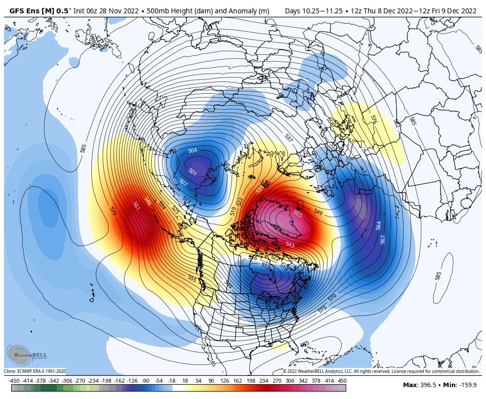
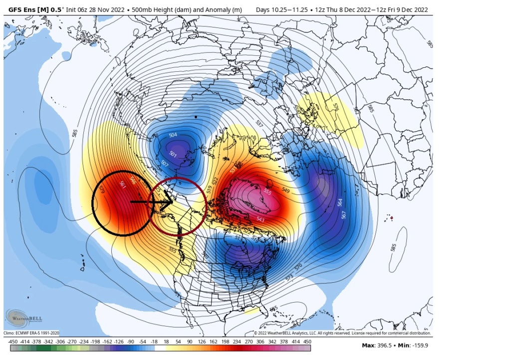
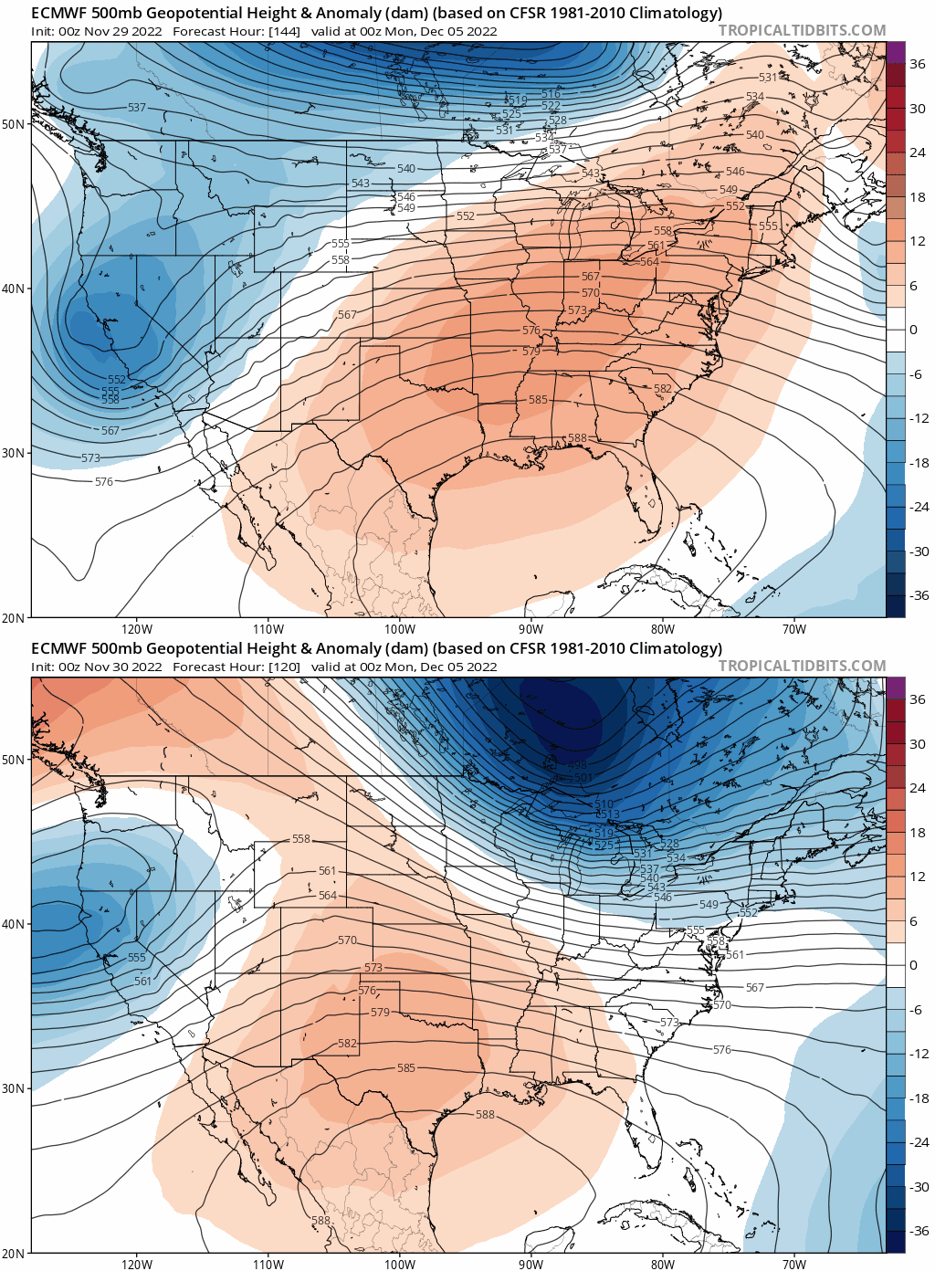
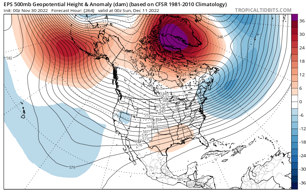
Good points on that. I don't believe there is going to be any major storm threat until the block retrogrades/breaks down more towards Hudson Bay and help the PNA with more amplification. It's one major reason I believe the substantial threat period is more mid-month than early month. What I believe to be different from last December 2021 1/we don't have the extreme hostile -PNA , 2/more favorable arctic domains at least as modelled. Now prior to mid-month as the blocking continues to cool the area there probably will be minor/moderate threats even at the coast as I don't think the PAC is that bad and it will be cold enough. I like 12/10-12/15ish for that and then from 12/17-12/25 something more substantial on the EC. This is the kind of blocking and PAC combo I've seen more often than not before a very wintry period on the EC. It's going to be interesting to see guidance in the next 10 days and hopefully it pans outsroc4 wrote:amugs wrote:The PNA goes neutral to slightly Positive - big win if it occurs for snow chances to the coastal plain. We have a stout Negative NAO (greenLand Block) and a Aluetian Block (Negative EPO) with a piece of the PV sitting over Hudson Bay. A very nice set up again IF it comes to fruitoin - we have all 3 globals saying so at this time.
This really doesn't look like a true -EPO alignment. IMO the Ridge needs to be N of the Aleutian Islands. So long as it is south of the Aleutians this will promote the tendency to place a trough along the WC of Canada and N CONUS and Pac energy will be constantly bombarding any attempted pos PNA spike. We need that ridge centered more over Alaska or at least over the Bering Sea, rather than south of the islands.
heehaw453- Advanced Forecaster

- Posts : 3932
Join date : 2014-01-20
sroc4 and amugs like this post
 Re: Long Range Thread 25.0
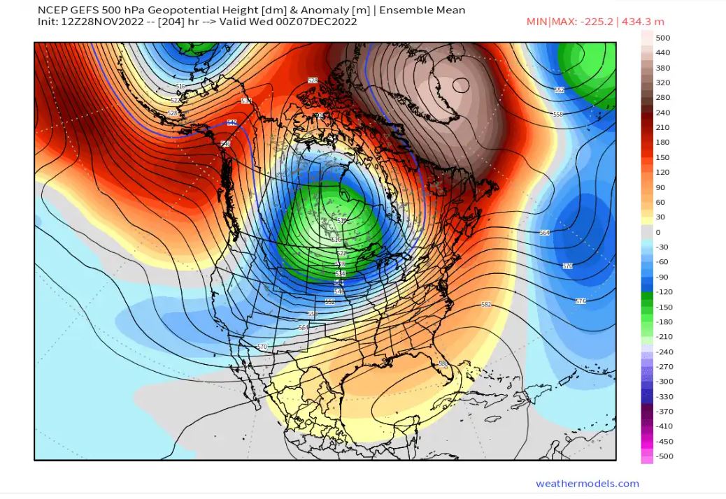
IF this occurs then peeps we gonna be busy!!!

amugs- Advanced Forecaster - Mod

- Posts : 15148
Join date : 2013-01-07
sroc4 likes this post
 Re: Long Range Thread 25.0
_________________
Mugs
AKA:King: Snow Weenie
Self Proclaimed
WINTER 2014-15 : 55.12" +.02 for 6 coatings (avg. 35")
WINTER 2015-16 Total - 29.8" (Avg 35")
WINTER 2016-17 : 39.5" so far

amugs- Advanced Forecaster - Mod

- Posts : 15148
Reputation : 213
Join date : 2013-01-07
Age : 54
Location : Hillsdale,NJ
heehaw453 likes this post
 Re: Long Range Thread 25.0

_________________
Mugs
AKA:King: Snow Weenie
Self Proclaimed
WINTER 2014-15 : 55.12" +.02 for 6 coatings (avg. 35")
WINTER 2015-16 Total - 29.8" (Avg 35")
WINTER 2016-17 : 39.5" so far

amugs- Advanced Forecaster - Mod

- Posts : 15148
Reputation : 213
Join date : 2013-01-07
Age : 54
Location : Hillsdale,NJ
heehaw453 and MattyICE like this post
 Re: Long Range Thread 25.0
Retrograding right to the Hudson Bay and amping up that PNA domain. Check this link and see how it matches up with some of the bigger storms to hit the NYC area. It's not imminent but it's eye candy for sure.amugs wrote:Tick tock tick tock - like clockwork!!
heehaw453- Advanced Forecaster

- Posts : 3932
Reputation : 86
Join date : 2014-01-20
Location : Bedminster Township, PA Elevation 600' ASL
 Re: Long Range Thread 25.0
In a Nov. 15 update to his long-range forecast, Cohen said a pattern that supports milder air is moving from the Ural Mountains to Greenland. That develops a pattern that supports colder weather in Siberia.
As a result, this would promote a polar vortex, the upper level low-pressure system that is present during the cool season, for South Jersey.
“I think if we get meaningful winter weather at least early on in the winter, it’s likely to come from a stretched polar vortex,” Cohen said.
The polar vortex normally spins like a top at the poles. However, it can be disrupted and dip into the United States. The vortex will do so either as a stretched event, where it stays as one unit but moves south, or by splitting into two, with one section moving toward the equator.
If the polar vortex is positioned over the Northeast, it will send the jet stream, the river of air roughly 30,000 feet high, south of New Jersey. That would unleash frigid air from the arctic, with opportunities for big snowstorms as well.
“We already had an extreme example of it (stretched polar vortex) earlier where places were having their big early snows and early record cold,” Cohen said.
Should that colder-than-average atmosphere not arrive, it’s likely the polar vortex will spin tightly like a top at the North Pole, keeping mild Pacific air flowing into the Northeast all winter long.

Irish- Pro Enthusiast

- Posts : 788
Reputation : 19
Join date : 2019-01-16
Age : 46
Location : Old Bridge, NJ
 Re: Long Range Thread 25.0
Irish wrote:https://pressofatlanticcity.com/weather/forecasts-point-to-early-snowy-start-for-new-jersey-winter/article_403837cc-6610-11ed-a3d1-ef3a4be2e40e.html
In a Nov. 15 update to his long-range forecast, Cohen said a pattern that supports milder air is moving from the Ural Mountains to Greenland. That develops a pattern that supports colder weather in Siberia.
As a result, this would promote a polar vortex, the upper level low-pressure system that is present during the cool season, for South Jersey.
“I think if we get meaningful winter weather at least early on in the winter, it’s likely to come from a stretched polar vortex,” Cohen said.
The polar vortex normally spins like a top at the poles. However, it can be disrupted and dip into the United States. The vortex will do so either as a stretched event, where it stays as one unit but moves south, or by splitting into two, with one section moving toward the equator.
If the polar vortex is positioned over the Northeast, it will send the jet stream, the river of air roughly 30,000 feet high, south of New Jersey. That would unleash frigid air from the arctic, with opportunities for big snowstorms as well.
“We already had an extreme example of it (stretched polar vortex) earlier where places were having their big early snows and early record cold,” Cohen said.
Should that colder-than-average atmosphere not arrive, it’s likely the polar vortex will spin tightly like a top at the North Pole, keeping mild Pacific air flowing into the Northeast all winter long.
Seems he might have offered these thoughts before we started to see some of these strong NAO trends show up on reliable guidance. Not sure if that would change his opinion - just an observation.
MattyICE- Advanced Forecaster

- Posts : 249
Reputation : 6
Join date : 2017-11-10
Age : 39
Location : Clifton, NJ (Eastern Passaic County)
Irish likes this post
 Re: Long Range Thread 25.0
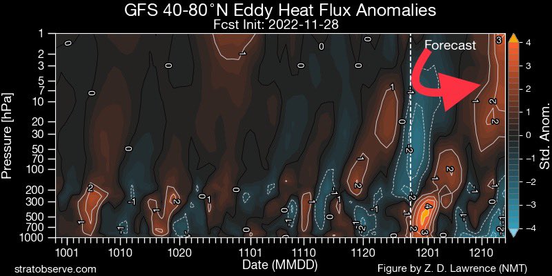
Big change in the European Ensemble forecast for the strength of the #PolarVortex from the 24th to today. On the 24th the ensemble mean was stronger than normal right through. Today it’s weaker than normal with a clustering near record weakness mid-December. #wxtwitter pic.twitter.com/d31qaD3sI2
— Mark Margavage (@MeteoMark) November 28, 2022
Yes you wil hear me harp ALL winter long on this BECAUSE it is again the greatest volcanic event of our modern history dating back to Tambora of 1815.
_________________
Mugs
AKA:King: Snow Weenie
Self Proclaimed
WINTER 2014-15 : 55.12" +.02 for 6 coatings (avg. 35")
WINTER 2015-16 Total - 29.8" (Avg 35")
WINTER 2016-17 : 39.5" so far

amugs- Advanced Forecaster - Mod

- Posts : 15148
Reputation : 213
Join date : 2013-01-07
Age : 54
Location : Hillsdale,NJ
 Re: Long Range Thread 25.0
Here comes the retrograding Greenland block. December will be an interesting month weather-wise... pic.twitter.com/QAXltxYWbx
— Ethan Sacoransky (@blizzardof96) November 29, 2022
_________________
Mugs
AKA:King: Snow Weenie
Self Proclaimed
WINTER 2014-15 : 55.12" +.02 for 6 coatings (avg. 35")
WINTER 2015-16 Total - 29.8" (Avg 35")
WINTER 2016-17 : 39.5" so far

amugs- Advanced Forecaster - Mod

- Posts : 15148
Reputation : 213
Join date : 2013-01-07
Age : 54
Location : Hillsdale,NJ
 Re: Long Range Thread 25.0
I was born visible, but I identify as invisible. My preferred pronouns are who/where.

dkodgis- Senior Enthusiast

- Posts : 2690
Reputation : 98
Join date : 2013-12-29
 Re: Long Range Thread 25.0
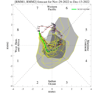
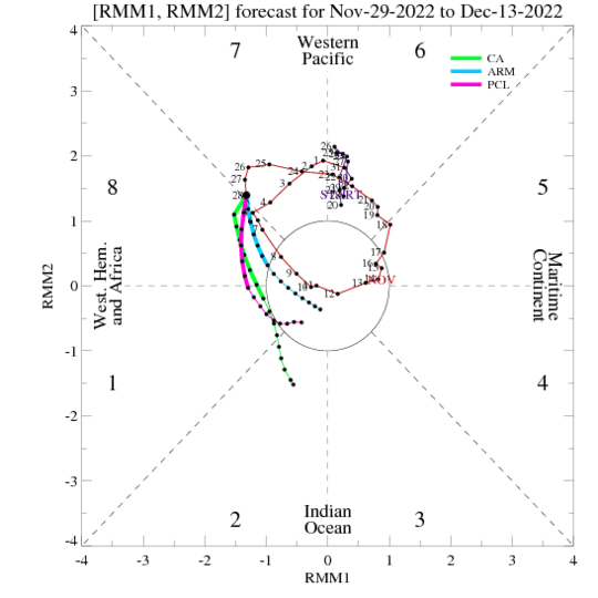
This is a nice wave progression but not into 4 nor 5 and back into COD after 2 or 3 would be ideal LOL!
_________________
Mugs
AKA:King: Snow Weenie
Self Proclaimed
WINTER 2014-15 : 55.12" +.02 for 6 coatings (avg. 35")
WINTER 2015-16 Total - 29.8" (Avg 35")
WINTER 2016-17 : 39.5" so far

amugs- Advanced Forecaster - Mod

- Posts : 15148
Reputation : 213
Join date : 2013-01-07
Age : 54
Location : Hillsdale,NJ
 Re: Long Range Thread 25.0


_________________
Mugs
AKA:King: Snow Weenie
Self Proclaimed
WINTER 2014-15 : 55.12" +.02 for 6 coatings (avg. 35")
WINTER 2015-16 Total - 29.8" (Avg 35")
WINTER 2016-17 : 39.5" so far

amugs- Advanced Forecaster - Mod

- Posts : 15148
Reputation : 213
Join date : 2013-01-07
Age : 54
Location : Hillsdale,NJ
 Re: Long Range Thread 25.0

_________________
Mugs
AKA:King: Snow Weenie
Self Proclaimed
WINTER 2014-15 : 55.12" +.02 for 6 coatings (avg. 35")
WINTER 2015-16 Total - 29.8" (Avg 35")
WINTER 2016-17 : 39.5" so far

amugs- Advanced Forecaster - Mod

- Posts : 15148
Reputation : 213
Join date : 2013-01-07
Age : 54
Location : Hillsdale,NJ
 Re: Long Range Thread 25.0

jmanley32- Senior Enthusiast

- Posts : 20645
Reputation : 108
Join date : 2013-12-12
Age : 43
Location : Yonkers, NY
 Re: Long Range Thread 25.0
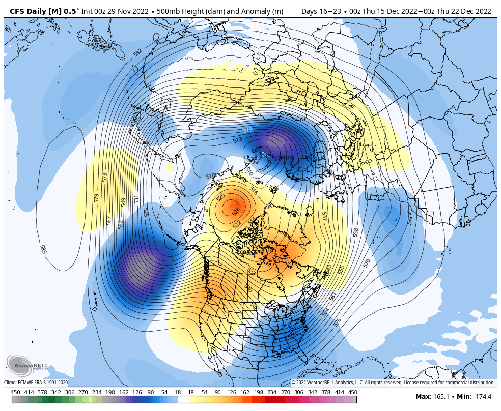
jmanley32 wrote:Sorry I am sure you guys covered it but I do not have time to read pages back. Is there any snow potential in the near future for NYC area/coastal plain or do we have to wait till Jan or later? Just curious.
By midish December we may see out 1st snow threat.
This is a matured winter pattern that would put some white gold around to help the Xmas spirit for sure.
_________________
Mugs
AKA:King: Snow Weenie
Self Proclaimed
WINTER 2014-15 : 55.12" +.02 for 6 coatings (avg. 35")
WINTER 2015-16 Total - 29.8" (Avg 35")
WINTER 2016-17 : 39.5" so far

amugs- Advanced Forecaster - Mod

- Posts : 15148
Reputation : 213
Join date : 2013-01-07
Age : 54
Location : Hillsdale,NJ
 Re: Long Range Thread 25.0
That 500mb map gives me that 2009/2010 vibe. Huge potential with a lot of sleepless nights awaits if the models are correct.amugs wrote:jmanley32 wrote:Sorry I am sure you guys covered it but I do not have time to read pages back. Is there any snow potential in the near future for NYC area/coastal plain or do we have to wait till Jan or later? Just curious.
By midish December we may see out 1st snow threat.
This is a matured winter pattern that would put some white gold around to help the Xmas spirit for sure.

nutleyblizzard- Senior Enthusiast

- Posts : 1963
Reputation : 41
Join date : 2014-01-30
Age : 58
Location : Nutley, new jersey
 Re: Long Range Thread 25.0
Last year I proved that 40 was my limit on sleepless nights lol, just can't do it anymore, only when I know I do not have to wake up the next day can I do it.nutleyblizzard wrote:That 500mb map gives me that 2009/2010 vibe. Huge potential with a lot of sleepless nights awaits if the models are correct.amugs wrote:jmanley32 wrote:Sorry I am sure you guys covered it but I do not have time to read pages back. Is there any snow potential in the near future for NYC area/coastal plain or do we have to wait till Jan or later? Just curious.
By midish December we may see out 1st snow threat.
This is a matured winter pattern that would put some white gold around to help the Xmas spirit for sure.

jmanley32- Senior Enthusiast

- Posts : 20645
Reputation : 108
Join date : 2013-12-12
Age : 43
Location : Yonkers, NY
 Re: Long Range Thread 25.0
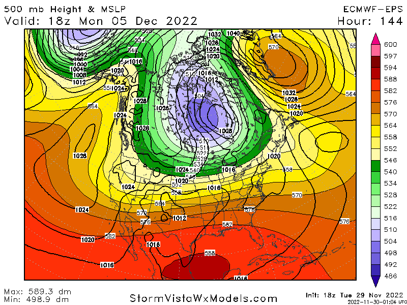
Great graphic by this kid.
Lol what, why, where did you come from? pic.twitter.com/r51zM7JcXE
— Matthew Ferreira | MassachusettsWx | SNEWxCenter! (@MassachusettsWx) November 30, 2022
_________________
Mugs
AKA:King: Snow Weenie
Self Proclaimed
WINTER 2014-15 : 55.12" +.02 for 6 coatings (avg. 35")
WINTER 2015-16 Total - 29.8" (Avg 35")
WINTER 2016-17 : 39.5" so far

amugs- Advanced Forecaster - Mod

- Posts : 15148
Reputation : 213
Join date : 2013-01-07
Age : 54
Location : Hillsdale,NJ
 Re: Long Range Thread 25.0
_________________
Mugs
AKA:King: Snow Weenie
Self Proclaimed
WINTER 2014-15 : 55.12" +.02 for 6 coatings (avg. 35")
WINTER 2015-16 Total - 29.8" (Avg 35")
WINTER 2016-17 : 39.5" so far

amugs- Advanced Forecaster - Mod

- Posts : 15148
Reputation : 213
Join date : 2013-01-07
Age : 54
Location : Hillsdale,NJ
 Re: Long Range Thread 25.0

_________________
Mugs
AKA:King: Snow Weenie
Self Proclaimed
WINTER 2014-15 : 55.12" +.02 for 6 coatings (avg. 35")
WINTER 2015-16 Total - 29.8" (Avg 35")
WINTER 2016-17 : 39.5" so far

amugs- Advanced Forecaster - Mod

- Posts : 15148
Reputation : 213
Join date : 2013-01-07
Age : 54
Location : Hillsdale,NJ
heehaw453- Advanced Forecaster

- Posts : 3932
Reputation : 86
Join date : 2014-01-20
Location : Bedminster Township, PA Elevation 600' ASL
 Re: Long Range Thread 25.0
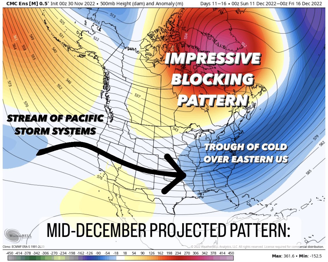
Fantasy storms are forming as well on models, the Great Billy Joel Sang - Its Just a Fantasy!! BUT they have some merrit with the blocking forming.
_________________
Mugs
AKA:King: Snow Weenie
Self Proclaimed
WINTER 2014-15 : 55.12" +.02 for 6 coatings (avg. 35")
WINTER 2015-16 Total - 29.8" (Avg 35")
WINTER 2016-17 : 39.5" so far

amugs- Advanced Forecaster - Mod

- Posts : 15148
Reputation : 213
Join date : 2013-01-07
Age : 54
Location : Hillsdale,NJ
 Re: Long Range Thread 25.0

We get the PNA rise and the press from the EPO and Greenland Block with the N AO, something may form and belly under that block. It's real and hopefully its spectactular!!
_________________
Mugs
AKA:King: Snow Weenie
Self Proclaimed
WINTER 2014-15 : 55.12" +.02 for 6 coatings (avg. 35")
WINTER 2015-16 Total - 29.8" (Avg 35")
WINTER 2016-17 : 39.5" so far

amugs- Advanced Forecaster - Mod

- Posts : 15148
Reputation : 213
Join date : 2013-01-07
Age : 54
Location : Hillsdale,NJ
 Re: Long Range Thread 25.0
The North Atlantic-European weather regime ensemble forecast shows a rapid buildup of Greenland Blocking soon with the weather regime index (IWR) exceeding 3 (!). Looking back at 40 years, this rarely occurred and would be off the scale. #LSDPatKIT pic.twitter.com/oW7fU2QFlZ
— Seraphine Hauser (@HauserSeraphine) November 30, 2022
This is where we are headaing - Hunga Tonga effect here?? I'd say so but we'll have to wait for the report, study.....months to a year(s) from now. Connect the dots - MASSIVE WARM SALT WATER BLOWN 36 MILES INTO THE SKY......MASSIVE WARM AIR ALOFT FORMING A MASSIVE WARM AIR BLOCK........Make sense, logic?
_________________
Mugs
AKA:King: Snow Weenie
Self Proclaimed
WINTER 2014-15 : 55.12" +.02 for 6 coatings (avg. 35")
WINTER 2015-16 Total - 29.8" (Avg 35")
WINTER 2016-17 : 39.5" so far

amugs- Advanced Forecaster - Mod

- Posts : 15148
Reputation : 213
Join date : 2013-01-07
Age : 54
Location : Hillsdale,NJ
heehaw453- Advanced Forecaster

- Posts : 3932
Reputation : 86
Join date : 2014-01-20
Location : Bedminster Township, PA Elevation 600' ASL
 Re: Long Range Thread 25.0
I said before something bellies under the 7-8th time frame.

_________________
Mugs
AKA:King: Snow Weenie
Self Proclaimed
WINTER 2014-15 : 55.12" +.02 for 6 coatings (avg. 35")
WINTER 2015-16 Total - 29.8" (Avg 35")
WINTER 2016-17 : 39.5" so far

amugs- Advanced Forecaster - Mod

- Posts : 15148
Reputation : 213
Join date : 2013-01-07
Age : 54
Location : Hillsdale,NJ
kalleg likes this post
 Re: Long Range Thread 25.0
From 33nRain Nick Psomaris

_________________
Mugs
AKA:King: Snow Weenie
Self Proclaimed
WINTER 2014-15 : 55.12" +.02 for 6 coatings (avg. 35")
WINTER 2015-16 Total - 29.8" (Avg 35")
WINTER 2016-17 : 39.5" so far

amugs- Advanced Forecaster - Mod

- Posts : 15148
Reputation : 213
Join date : 2013-01-07
Age : 54
Location : Hillsdale,NJ
Page 5 of 40 •  1, 2, 3, 4, 5, 6 ... 22 ... 40

 Home
Home