Long Range Thread 25.0
Page 27 of 40 •  1 ... 15 ... 26, 27, 28 ... 33 ... 40
 Re: Long Range Thread 25.0
jmanley32 wrote:I will be right in that dark red frz zone, great, at least I will not be going anywhere until Tuesday after I get there. If I am leaving to CT Sunday should I go early or later to avoid driving in any wintry precip, haven't had much experience this year I may have forgotten lol?
Jon You may not want to drive at all. Winds 45-55mph and looks like your drive is slated for 10-15" Could get messy.

sroc4- Admin

- Posts : 8458
Join date : 2013-01-07
 Re: Long Range Thread 25.0
_________________
"In weather and in life, there's no winning and losing; there's only winning and learning."
WINTER 2012/2013 TOTALS 43.65"WINTER 2017/2018 TOTALS 62.85" WINTER 2022/2023 TOTALS 4.9"
WINTER 2013/2014 TOTALS 64.85"WINTER 2018/2019 TOTALS 14.25" WINTER 2023/2024 TOTALS 13.1"
WINTER 2014/2015 TOTALS 71.20"WINTER 2019/2020 TOTALS 6.35" WINTER 2024/2025 TOTALS 0.00
WINTER 2015/2016 TOTALS 35.00"WINTER 2020/2021 TOTALS 37.75"
WINTER 2016/2017 TOTALS 42.25"WINTER 2021/2022 TOTALS 31.65"

sroc4- Admin

- Posts : 8458
Reputation : 302
Join date : 2013-01-07
Location : Wading River, LI
 Re: Long Range Thread 25.0
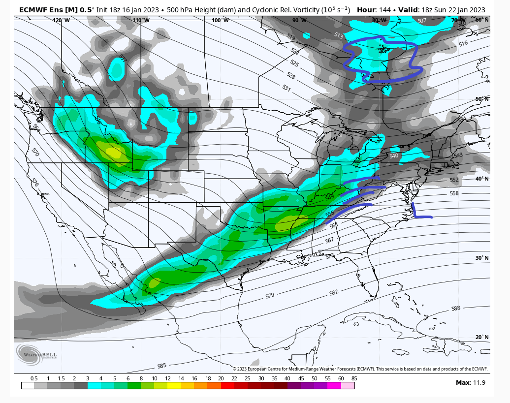
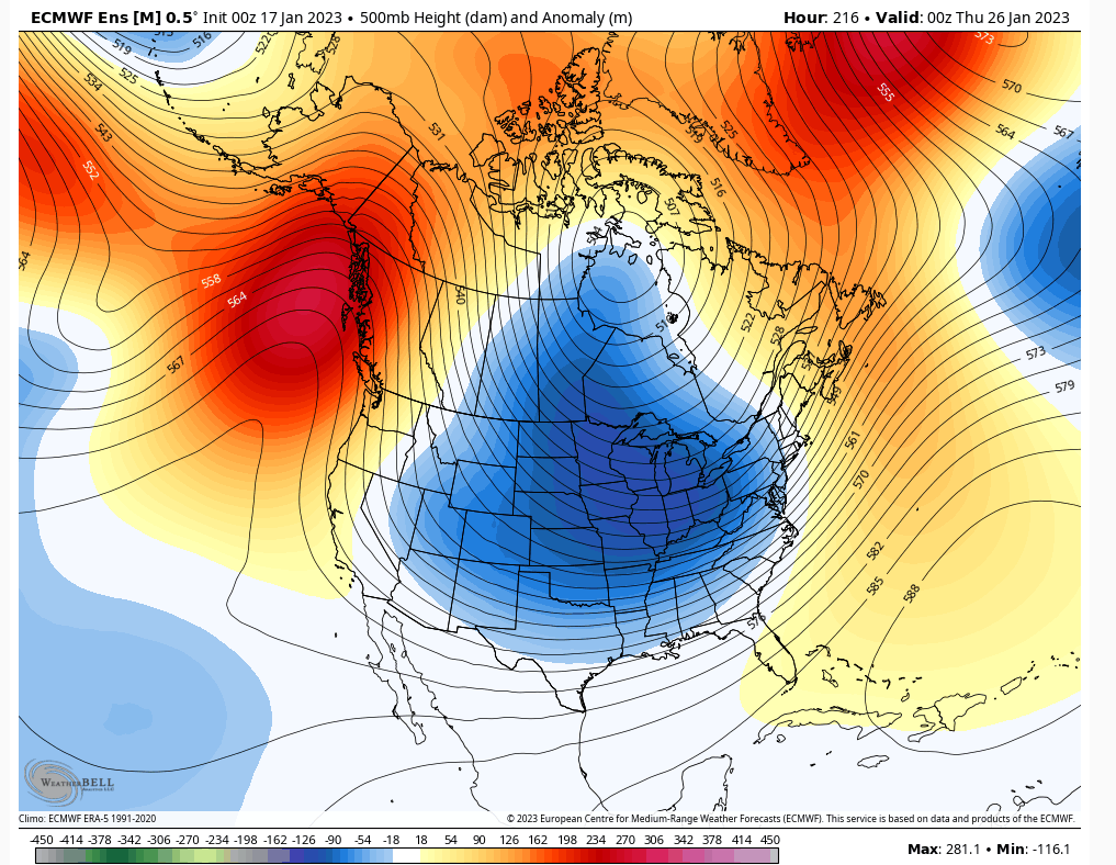
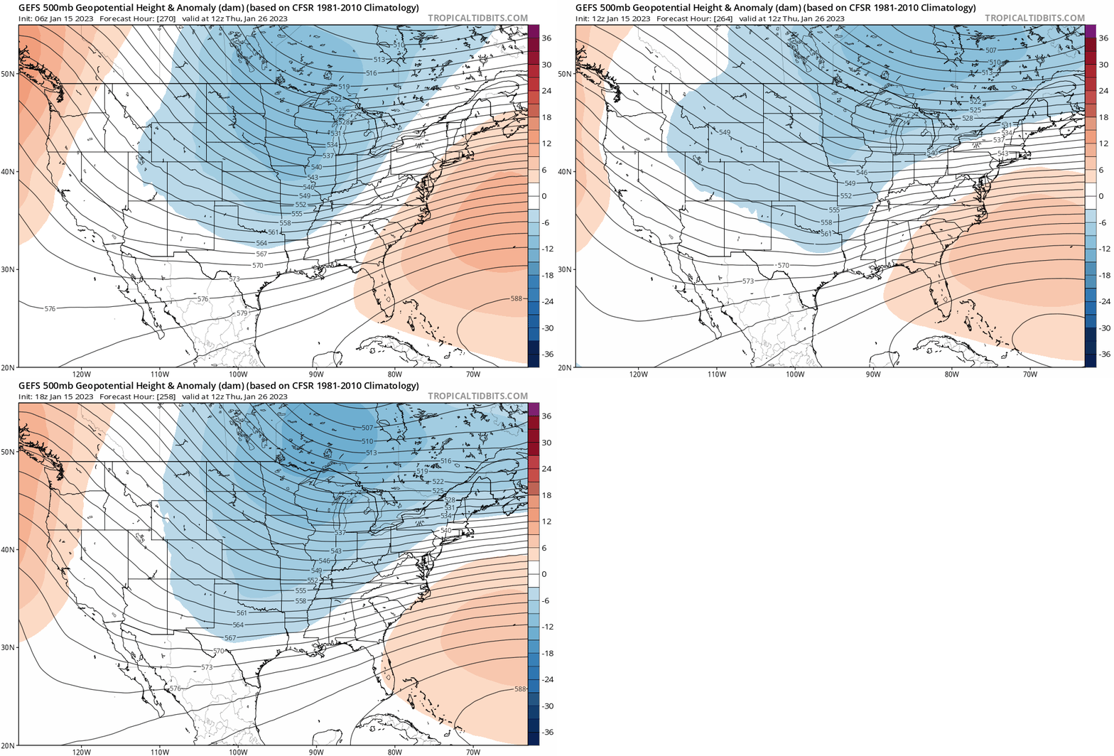
Yep. Much different looks aren't they. Rooting for the EPS, but preparing for the GEFS.
heehaw453- Advanced Forecaster

- Posts : 3931
Reputation : 86
Join date : 2014-01-20
Location : Bedminster Township, PA Elevation 600' ASL
sroc4 likes this post
 Re: Long Range Thread 25.0
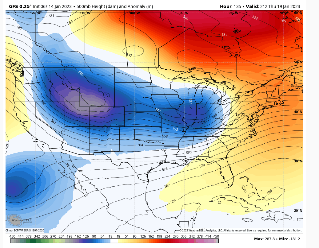
Thursday cutter note the ridge where it has become very comfortable this season. It is what it is folks and don't believe anything changes until you see the whites of its eyes. No debbie downer talk just saying what i see.
heehaw453- Advanced Forecaster

- Posts : 3931
Reputation : 86
Join date : 2014-01-20
Location : Bedminster Township, PA Elevation 600' ASL
sroc4 likes this post
 Re: Long Range Thread 25.0
_________________
Mugs
AKA:King: Snow Weenie
Self Proclaimed
WINTER 2014-15 : 55.12" +.02 for 6 coatings (avg. 35")
WINTER 2015-16 Total - 29.8" (Avg 35")
WINTER 2016-17 : 39.5" so far

amugs- Advanced Forecaster - Mod

- Posts : 15148
Reputation : 213
Join date : 2013-01-07
Age : 54
Location : Hillsdale,NJ
 Re: Long Range Thread 25.0
I think the issue we are having is these tropical waves are dying around 120E. Scott can correct me if I’m wrong but that’s about phase 4-5 of the MJO? Back in December we saw anomalous westerly wind bursts that started near 80E and propagate to 120E. That allowed planetary waves to make their way up to the Stratosphere and deliver record cold to the eastern CONUS.

We’re seeing different type of scenario unfold. It looks like the Strat PV will get squeezed from both sides of the Pole. This is also know as a Wave 2 event. I think this will lead to significant disruption which models will have a difficult time handling. I’ve been saying January 25th (+\-) 3 days for a pattern change. I’m going to stick to that…for now…
_________________
_______________________________________________________________________________________________________
CLICK HERE to view NJ Strong Snowstorm Classifications
 Re: Long Range Thread 25.0
Frank_Wx wrote:
I think the issue we are having is these tropical waves are dying around 120E. Scott can correct me if I’m wrong but that’s about phase 4-5 of the MJO? Back in December we saw anomalous westerly wind bursts that started near 80E and propagate to 120E. That allowed planetary waves to make their way up to the Stratosphere and deliver record cold to the eastern CONUS.
We’re seeing different type of scenario unfold. It looks like the Strat PV will get squeezed from both sides of the Pole. This is also know as a Wave 2 event. I think this will lead to significant disruption which models will have a difficult time handling. I’ve been saying January 25th (+\-) 3 days for a pattern change. I’m going to stick to that…for now…
You nailed it Frank regarding these tropical waves. Looking at the Outgoing Longwave Radiation, (OLR) maps, you can see quite clearly the rising motion has been pretty much contained/centered to the region consistent with an MJO phase 4-5 the entire winter season with overlap into the phases 3 on the western side and 6 on the eastern. Below is the 30day and 90 day avg OLR maps, and the general MJO phase composites depicting the pattern typically seen for the individual phases of the MJO for Dec, Jan, and Feb.


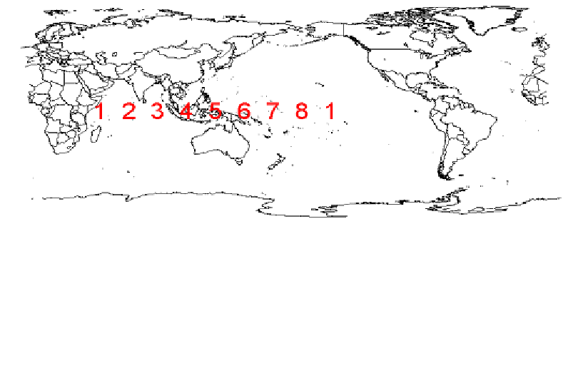
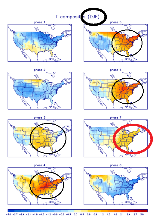
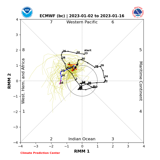
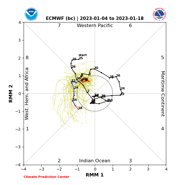
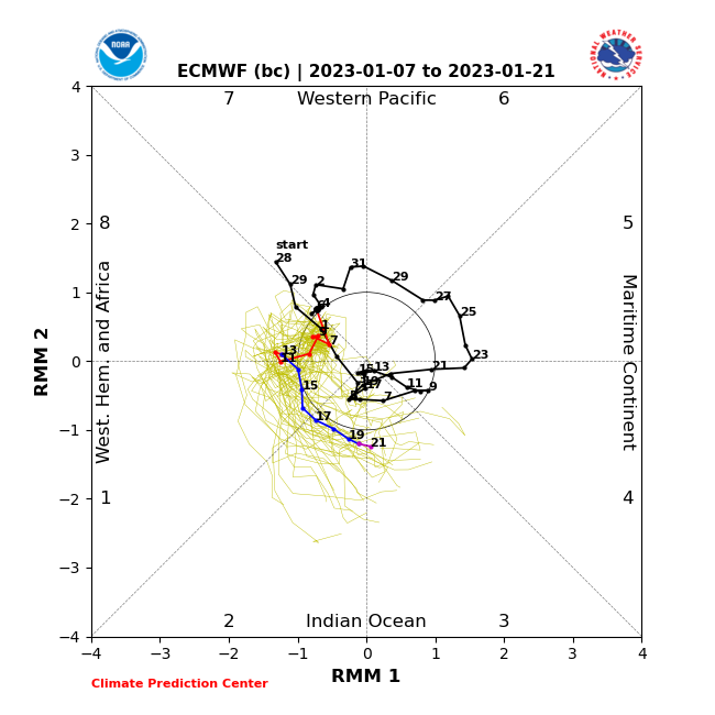
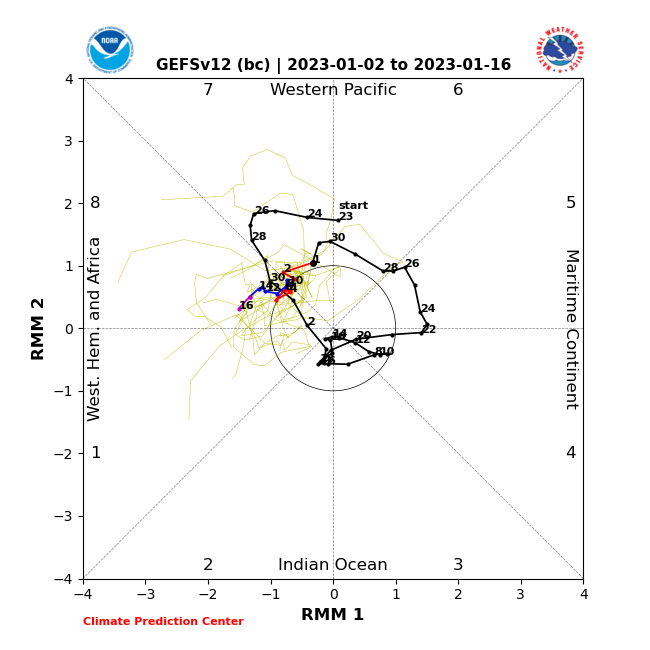
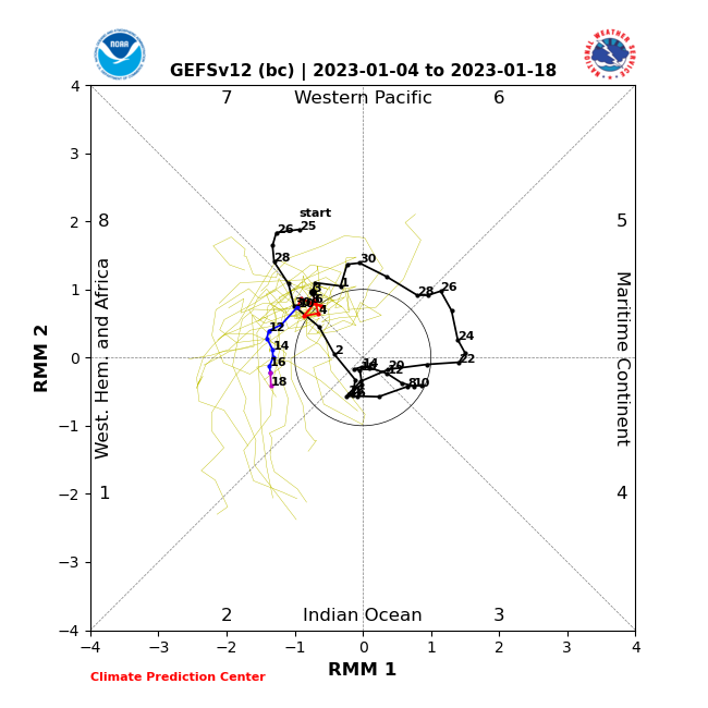
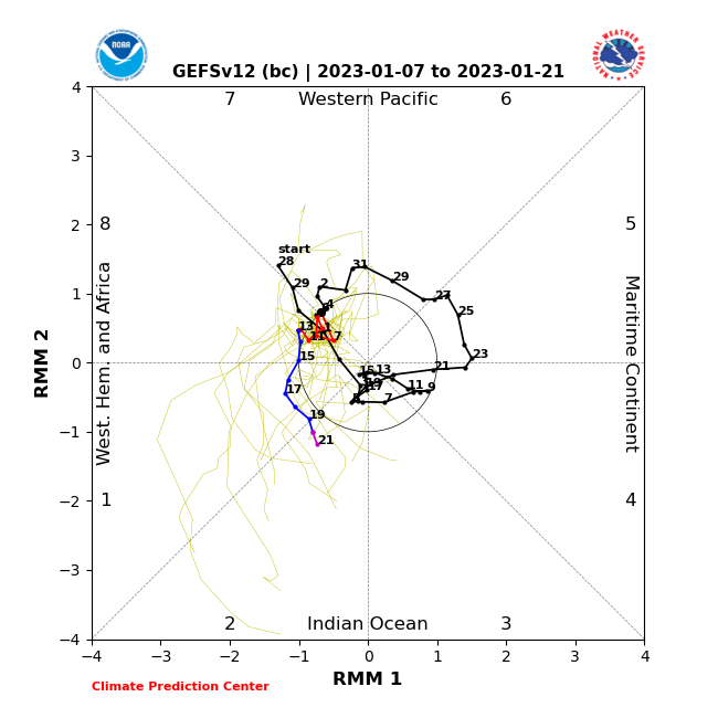
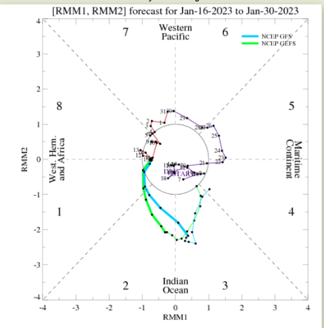
Now I had a post several days ago looking at the MJO forecasts. I showed how that the forecast back on Jan 2nd had the MJO pulse coming out in phase 8, and traversing east through phases 1; then 2. But after several days went by the forecast from both the GEFS and EPS was trending weaker:
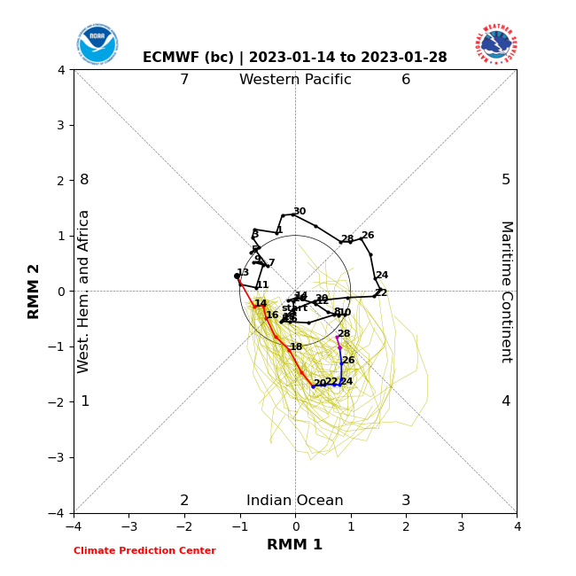
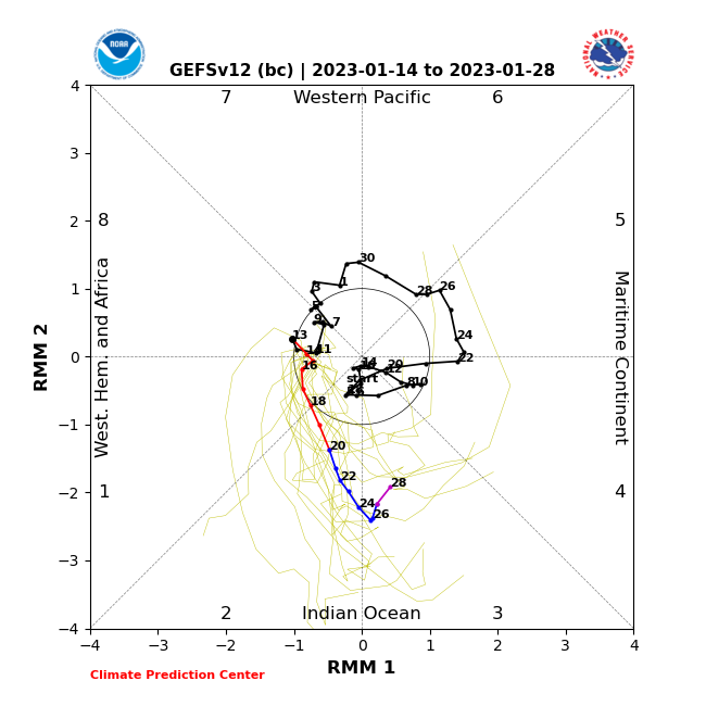
sroc4 wrote:So I've been monitoring the MJO forecasts because there has been enthusiastic talk about it finally coming out in the favorable phases of 8 and propagating from 8-1-2 which would be great for a trough in the east and multiple snow threats. But as Im about to show the trend since the 2nd of the year has been less and less amplitude with time, and perhaps not even coming out in 8 at all. The trend for when it comes out of the center is more towards the 8-1 line just outside the center/null phase. My concern would be if this trend conts then the MJO really wont actually pulse out of the circle of death COD.
NOTE: First Euro MJO forecast Then GFS. And if you need a refresher or are unsure exactly what the MJO is click the link below.
https://www.njstrongweatherforum.com/t511-what-is-the-mjo-really
EURO
GFS
As you can now see with todays MJO forecast my fears are coming to fruition. It appears once again we are failing to make it out of the COD and now appear to not make it into even 1-2 either and appear to be headed back out to 3.
[ url=https://servimg.com/view/18491850/3910]
 [/url]
As you can see by the latest OLR 7day average we still have convection centered over the the area consistent with phases 4-5 of the MJO with the western and eastern flanks of the cold colors on the OLR maps overlapping in phases 3 and 6 respectively.
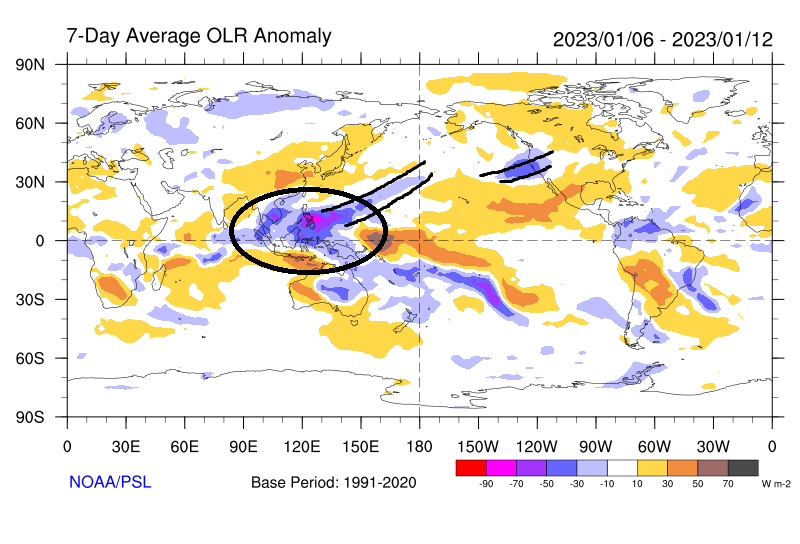
Its pretty clear what phase 3-4-5-6 depict in the east during the Dec, Jan, Feb time frame. But you may ask the question Why is the atmosphere behaving like its in those warm phases when for the most part in the recent past the MJO forecast maps have shown the MJO within the COD?
Well enter back in the ENSO status. We are in a mild-mod to Mod La Nina. On top of that not only are we in a La Nina this winter, we have been in a La Nina for 3 consecutive winters. We all know H2O has unique properties such that it does not fluctuate temperatures as quickly as air does as seen by air temperature over areas like Long Island, surrounded by water, stay cooler for longer in the spring and warmer for longer in the fall.
We have been in a pretty well established sea surface temp anomaly pattern in the tropical pacific for quite some time. In addition to that the SSTA pattern in the Indian Ocean has been consistent as well.
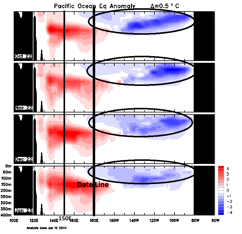
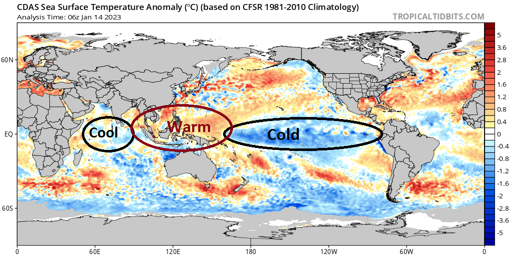

So while we haven't exactly had a strong MJO pulse as indicated by the MJO forecast maps above, the overall back ground state of the 3 yr running La Nina combined with this winters Indian Ocean(IO) SSTA its clear to me that it makes sense as to why things have played out how they have thus far. The OLR/Convection is centered over the warm phases of 3-4-5-6 of the MJO. Based on the SSTA map above you have cold anomalies in the western IO that then transition to warm SSTA as we enter the Eastern IO in through the Philippians and Indonesian Islands and western Pac.; then the cold anomalies all the way through to the eastern Trop Pac. If you were going to have rising air along the equator and you had one guess where it would center itself just looking at that SSTA map where would you guess? Over the warm pool or one of the cold pools?
Exactly!
I have to say after really analyzing some of this I fear that unless acted upon by some other major drivers any attempts at the MJO coming out in any other phases than 3-4--5-6 RIGHT NOW are likely to be thwarted by this back ground state established by the equatorial SSTA and be either short lived, or end up non existent like this apparent failed attempt at coming out into 8-1-2. In fact unless something changes I would not be surprised to see the latest MJO forecast I posted above trend out in 3 and actually make it into 4-5.
Things like a stratospheric vortex shake up, which has some potential on the horizon, OR a rapid collapse of the La Nina on at least the western flank of the Trop Pac, which I believe is less likely to occur, needs to happen in order to salvage anything out of this winter.
This winter is like the National title game between Georgia and TCU. In hind sight that game was over in the first half. But it was officially over after the first 5-7mins of the 3rd quarter. By this time next week we will likely be 5-7mins into the third quarter. The question for us now is even though there is zero chance we win the game, can winter 2022/2023 at least save face by playing hard; with pride, and score a few points to gain some respect when its all over? OR do we cont to get blown out and end up losing 65-7 in the end and say this was one of the worst title games, I mean winters, ever played?? Well see. For me for now if the strat thing fails this could go down as the worst winter ever for many.
Last edited by sroc4 on Sat Jan 14, 2023 4:15 pm; edited 1 time in total
_________________
"In weather and in life, there's no winning and losing; there's only winning and learning."
WINTER 2012/2013 TOTALS 43.65"WINTER 2017/2018 TOTALS 62.85" WINTER 2022/2023 TOTALS 4.9"
WINTER 2013/2014 TOTALS 64.85"WINTER 2018/2019 TOTALS 14.25" WINTER 2023/2024 TOTALS 13.1"
WINTER 2014/2015 TOTALS 71.20"WINTER 2019/2020 TOTALS 6.35" WINTER 2024/2025 TOTALS 0.00
WINTER 2015/2016 TOTALS 35.00"WINTER 2020/2021 TOTALS 37.75"
WINTER 2016/2017 TOTALS 42.25"WINTER 2021/2022 TOTALS 31.65"

sroc4- Admin

- Posts : 8458
Reputation : 302
Join date : 2013-01-07
Location : Wading River, LI
Frank_Wx, amugs and heehaw453 like this post
 Re: Long Range Thread 25.0

dkodgis- Senior Enthusiast

- Posts : 2688
Reputation : 98
Join date : 2013-12-29
 Re: Long Range Thread 25.0
Watch what will happen, we get the last two weeks of Feb and run cold and BN temps through Spring.
My bet is with Frank on the Stratosphere and playing that hand.
_________________
Mugs
AKA:King: Snow Weenie
Self Proclaimed
WINTER 2014-15 : 55.12" +.02 for 6 coatings (avg. 35")
WINTER 2015-16 Total - 29.8" (Avg 35")
WINTER 2016-17 : 39.5" so far

amugs- Advanced Forecaster - Mod

- Posts : 15148
Reputation : 213
Join date : 2013-01-07
Age : 54
Location : Hillsdale,NJ
Frank_Wx likes this post
 Re: Long Range Thread 25.0
https://www.westernjournal.com/thought-decembers-arctic-blast-bad-something-much-worse-barreling-toward-america/?utm_source=RSSfeed&utm_medium=RSSfeed&utm_campaign=RSSfeed&utm_content=2023-01-14&fr=operanews

dkodgis- Senior Enthusiast

- Posts : 2688
Reputation : 98
Join date : 2013-12-29
 Re: Long Range Thread 25.0
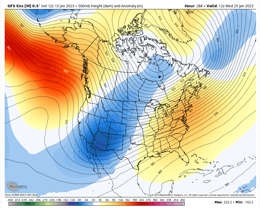
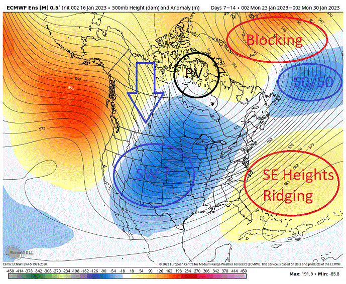
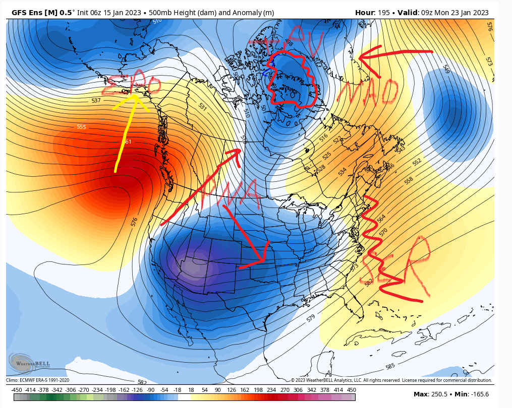
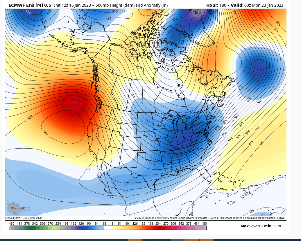
What I see on the GEFS looks ugly at first but the key is that TPV over Hudson Bay. Keep it there and higher heights will build in above it in the NAO domain and it will squeeze cold air right down to the EC. The trough in AZ area will pivot and the higher heights will build into the EPO. Also that NAO support will tend to displace the SER off the coast and not on the coast.
We don't have unlimited time for stuff to start working out for us. So if this busts hard then don't expect magic in February.
heehaw453- Advanced Forecaster

- Posts : 3931
Reputation : 86
Join date : 2014-01-20
Location : Bedminster Township, PA Elevation 600' ASL
MattyICE likes this post
 Re: Long Range Thread 25.0
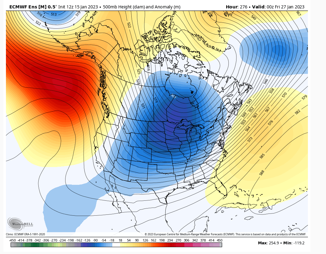
Give it a few days to see if it has any teeth, but I like the following 1/ridge popping in west, 2/50/50 low, 3/later development of storm, 4/TPV placement and 5/good antecedent air mass. Much better look for actual snow to fall from the sky and stick than having to ferret out warm air ahead of a pumped up EC ridge. Coupled with the a storm that is maturing as it approaches and not closed off over MO.
heehaw453- Advanced Forecaster

- Posts : 3931
Reputation : 86
Join date : 2014-01-20
Location : Bedminster Township, PA Elevation 600' ASL
 Re: Long Range Thread 25.0
heehaw453- Advanced Forecaster

- Posts : 3931
Reputation : 86
Join date : 2014-01-20
Location : Bedminster Township, PA Elevation 600' ASL
 Re: Long Range Thread 25.0
heehaw453 wrote:Others may not like this look in long range due to PNA, but i do. -NAO with TPV bleeding cold air down and separating the SER. Also seeing some subtropical interaction with the main trough. This is cold air providing an overrunning platform. Not blockbuster snowstorms but a platform for snow between the trough and the ridge. My main concerns are getting that cold down to EC and kicking back that SER. This does both and TPV is going to be key to this.
Definitely a split flow look. Key to the TPV is the positive heights up into Alaska AKA -EPO. You can def get a cold press with waves of Lp along a boundary. Def better look than we have had. Problem is as the run plays out this seems temporary. Ridge and trough retrogrades further west opening the window for the SER to flex back up. MJO plots today show an actual phase 2 with amplitude so this might be for real. Still the LR and goal posts have been pushed back all winter so cautious optimism required.
_________________
"In weather and in life, there's no winning and losing; there's only winning and learning."
WINTER 2012/2013 TOTALS 43.65"WINTER 2017/2018 TOTALS 62.85" WINTER 2022/2023 TOTALS 4.9"
WINTER 2013/2014 TOTALS 64.85"WINTER 2018/2019 TOTALS 14.25" WINTER 2023/2024 TOTALS 13.1"
WINTER 2014/2015 TOTALS 71.20"WINTER 2019/2020 TOTALS 6.35" WINTER 2024/2025 TOTALS 0.00
WINTER 2015/2016 TOTALS 35.00"WINTER 2020/2021 TOTALS 37.75"
WINTER 2016/2017 TOTALS 42.25"WINTER 2021/2022 TOTALS 31.65"

sroc4- Admin

- Posts : 8458
Reputation : 302
Join date : 2013-01-07
Location : Wading River, LI
 Re: Long Range Thread 25.0
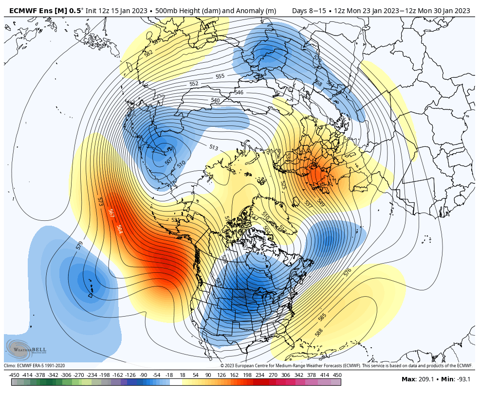
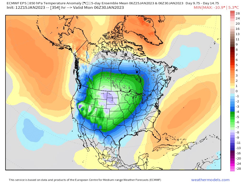
1-25ish timeframe to watch.
Good trends since yesterday IMO.


Rule of thumb when it gets hot, hot, hot in stratosphere 6-20km above Earth’s surface, right over the North Pole. It can get cold, cold, cold in troposphere, lowest layer of atmosphere where weather happens & where humans live. :flag_us: model really raising eyebrows now. #PolarVortex pic.twitter.com/hBhMc92nDZ
— London & Southeast :snowman: :snowflake: (@TheSnowDreamer) January 15, 2023
_________________
Mugs
AKA:King: Snow Weenie
Self Proclaimed
WINTER 2014-15 : 55.12" +.02 for 6 coatings (avg. 35")
WINTER 2015-16 Total - 29.8" (Avg 35")
WINTER 2016-17 : 39.5" so far

amugs- Advanced Forecaster - Mod

- Posts : 15148
Reputation : 213
Join date : 2013-01-07
Age : 54
Location : Hillsdale,NJ
SENJsnowman likes this post
 Re: Long Range Thread 25.0
Yeah Mugs the difference between December's pattern and upcoming one maybe the TPV stretching. If it sets up shop Hudson Bay or a bit to the east then we are in good shape. The NAO won't be able to link up easily with the SER as the TPV trough will pinch it off. Then we get an active winter pattern maybeamugs wrote:All the gloom and doom. Your EPS and GEFS are correcting to squashing the SE Ridge and the PV gets stretched.
1-25ish timeframe to watch.
Good trends since yesterday IMO.Rule of thumb when it gets hot, hot, hot in stratosphere 6-20km above Earth’s surface, right over the North Pole. It can get cold, cold, cold in troposphere, lowest layer of atmosphere where weather happens & where humans live. :flag_us: model really raising eyebrows now. #PolarVortex pic.twitter.com/hBhMc92nDZ
— London & Southeast :snowman: :snowflake: (@TheSnowDreamer) January 15, 2023
heehaw453- Advanced Forecaster

- Posts : 3931
Reputation : 86
Join date : 2014-01-20
Location : Bedminster Township, PA Elevation 600' ASL
SENJsnowman likes this post
 Re: Long Range Thread 25.0
_________________
Mugs
AKA:King: Snow Weenie
Self Proclaimed
WINTER 2014-15 : 55.12" +.02 for 6 coatings (avg. 35")
WINTER 2015-16 Total - 29.8" (Avg 35")
WINTER 2016-17 : 39.5" so far

amugs- Advanced Forecaster - Mod

- Posts : 15148
Reputation : 213
Join date : 2013-01-07
Age : 54
Location : Hillsdale,NJ
heehaw453 likes this post
 Re: Long Range Thread 25.0

heehaw453- Advanced Forecaster

- Posts : 3931
Reputation : 86
Join date : 2014-01-20
Location : Bedminster Township, PA Elevation 600' ASL
 Re: Long Range Thread 25.0
Where was that now map from? Was that the snow map for this potential storm that missed?sroc4 wrote:jmanley32 wrote:I will be right in that dark red frz zone, great, at least I will not be going anywhere until Tuesday after I get there. If I am leaving to CT Sunday should I go early or later to avoid driving in any wintry precip, haven't had much experience this year I may have forgotten lol?
Jon You may not want to drive at all. Winds 45-55mph and looks like your drive is slated for 10-15" Could get messy.

jmanley32- Senior Enthusiast

- Posts : 20645
Reputation : 108
Join date : 2013-12-12
Age : 43
Location : Yonkers, NY
heehaw453- Advanced Forecaster

- Posts : 3931
Reputation : 86
Join date : 2014-01-20
Location : Bedminster Township, PA Elevation 600' ASL
CPcantmeasuresnow and SENJsnowman like this post
 Re: Long Range Thread 25.0
btw the ops runs at this range especially GFS have very little insight. GFS has a big cutter going through through Lake Erie, but its ensemble suite not so much.
heehaw453- Advanced Forecaster

- Posts : 3931
Reputation : 86
Join date : 2014-01-20
Location : Bedminster Township, PA Elevation 600' ASL
heehaw453- Advanced Forecaster

- Posts : 3931
Reputation : 86
Join date : 2014-01-20
Location : Bedminster Township, PA Elevation 600' ASL
amugs likes this post
 Re: Long Range Thread 25.0
This is an impressive jet stream pattern over the southern & eastern U.S. during late January
— Ben Noll (@BenNollWeather) January 16, 2023
It will be conducive to frequent, moisture-laden storms.
During the next 2-3 weeks, some central & northern states that have so far lacked snow may see their fortunes changepic.twitter.com/zouiURWkzK
_________________
Mugs
AKA:King: Snow Weenie
Self Proclaimed
WINTER 2014-15 : 55.12" +.02 for 6 coatings (avg. 35")
WINTER 2015-16 Total - 29.8" (Avg 35")
WINTER 2016-17 : 39.5" so far

amugs- Advanced Forecaster - Mod

- Posts : 15148
Reputation : 213
Join date : 2013-01-07
Age : 54
Location : Hillsdale,NJ
heehaw453 likes this post
 Re: Long Range Thread 25.0
_________________
Mugs
AKA:King: Snow Weenie
Self Proclaimed
WINTER 2014-15 : 55.12" +.02 for 6 coatings (avg. 35")
WINTER 2015-16 Total - 29.8" (Avg 35")
WINTER 2016-17 : 39.5" so far

amugs- Advanced Forecaster - Mod

- Posts : 15148
Reputation : 213
Join date : 2013-01-07
Age : 54
Location : Hillsdale,NJ
 Re: Long Range Thread 25.0
_________________
Mugs
AKA:King: Snow Weenie
Self Proclaimed
WINTER 2014-15 : 55.12" +.02 for 6 coatings (avg. 35")
WINTER 2015-16 Total - 29.8" (Avg 35")
WINTER 2016-17 : 39.5" so far

amugs- Advanced Forecaster - Mod

- Posts : 15148
Reputation : 213
Join date : 2013-01-07
Age : 54
Location : Hillsdale,NJ
 Re: Long Range Thread 25.0
Now admit it. You thought winter was over!
Guess again. The classic January Thaw configuration is collapsing after a 2.5 week stay in North America. This change is achieved by a shift in the volatile storm sequence from the Pacific Ocean eastward into the lower 48 states, with concurrent ridge formation in the Gulf of Alaska and over the northern Atlantic Ocean. The flat split flow aloft will be replaced by a deep bowl shaped trough at 500MB allowing an Arctic regime over northers Canada to be displaced (quickly, I might add....) southward to the right of the Continental Divide. Each disturbance in the series will yank the colder air southward, with only Florida escaping the winter chill.
The first impulse in the group may set up snow chances in the Missouri Valley and Upper Midwest, with a risk of strong/severe thunderstorms from parts of Texas and Oklahoma into the Mid-South and Ohio Valley. The drop in temperature behind this first system will be marginal. But the next two pieces of energy will produce a rude shock/surprise.

Early next week a combination of a polar and subtropical jet stream shortwaves will strengthen and reform in the western Gulf of Mexico. Following the ECMWF model scenario, this new area of low pressure pulls colder air all the way down to Mexico and begins a trajectory through the Deep South before turning up along the Eastern Seaboard. The rightward shift in this path forecast in recent model runs is irksome. But for now I see this as a rain and thunder event for Interstate 95 communities and a rain/ice/snow change along and 150 miles to the left of the track. That could put parts of TX/OK into the Midwest and lower Great Lakes in some frozen precipitation.
In about ten days, when most of the nation (outside of the Florida Peninsula) is in polar or Arctic air, a wave in northern Mexico will begin a deepening phase as it heads eastward below the Gulf Coast. All who want to see a credible ice and snow threat in the Deep South and Eastern Seaboard need to watch this feature.
_________________
Mugs
AKA:King: Snow Weenie
Self Proclaimed
WINTER 2014-15 : 55.12" +.02 for 6 coatings (avg. 35")
WINTER 2015-16 Total - 29.8" (Avg 35")
WINTER 2016-17 : 39.5" so far

amugs- Advanced Forecaster - Mod

- Posts : 15148
Reputation : 213
Join date : 2013-01-07
Age : 54
Location : Hillsdale,NJ
Page 27 of 40 •  1 ... 15 ... 26, 27, 28 ... 33 ... 40

 Home
Home
