
 Search
2023 Atlantic Tropics season
Page 13 of 20 •  1 ... 8 ... 12, 13, 14 ... 16 ... 20
 ![]()
Re: 2023 Atlantic Tropics season
![]() by sroc4 Sun Sep 10, 2023 8:43 am
by sroc4 Sun Sep 10, 2023 8:43 am


I am taking a direct hit between the Cape and the Delmarva off the table. In fact I'm going to to say anything S of Atlantic City is off my table for a direct landfall. I am going to put a direct US Landfall, Atlantic city through eastern Maine, at a 15-30% chance of happening from west to east respectively. The trend has been for a deeper and stronger trough and a weaker N Atlantic ridge which would increase the likely hood of a recurve. Now keep in mind there is still uncertainty. These are my thoughts as of the current information available; however as we know things are subject to change should the next 2-3days trend differently that the past 2-3 days. The timing of the trough lifting out relative to the system really holds the key. The only way it lifts out before Lee gains too much latitude is if he trends to the south side of the current forecast cone as stated above.

sroc4- Admin

- Posts : 8390
Join date : 2013-01-07
kalleg and rb924119 like this post
Re: 2023 Atlantic Tropics season
![]() by amugs Sun Sep 10, 2023 9:22 am
by amugs Sun Sep 10, 2023 9:22 am
CONSISTENCY IN RIDGE STRENGTH HOLDS OVER CANADIAN MARITIMES AS #LEE MOVES NORTH THIS WEEK
— Mike Masco (@MikeMasco) September 10, 2023
You're just not going to get the model consistency you need right now for the overall surface track of #HurricaneLee for later this week. As you saw in yesterday's European model run the… pic.twitter.com/LAZb0RE3qw
Depiction of how Margot which is stronger and more west = breaks the ridge down in the North Atlantic thus weakening it and the Upper Level trough over the GL. The trough cant pull Lee closer to teh coast and the Ridge allows him in concert to lift further NE. A delicate balance but again one run. windshiled wiper effect at full play here? Slight chnages mean a sliver of space in our world but major changes for us overall.
amugs- Advanced Forecaster - Mod

- Posts : 15095
Join date : 2013-01-07
Re: 2023 Atlantic Tropics season
![]() by jmanley32 Sun Sep 10, 2023 10:58 am
by jmanley32 Sun Sep 10, 2023 10:58 am
Lee has increased a bit to 110mph, very close to Major again but I dunno why he looks so horrible (I know the shear but still, you would think this was a minimal cat 1 by looking at him), i mean a strong cat 2 you would think would have a eye and not just look like a massive blob.

jmanley32- Senior Enthusiast

- Posts : 20593
Reputation : 108
Join date : 2013-12-12
Age : 43
Location : Yonkers, NY
Re: 2023 Atlantic Tropics season
![]() by sroc4 Sun Sep 10, 2023 11:09 am
by sroc4 Sun Sep 10, 2023 11:09 am
jmanley32 wrote:Interesting Analysis above, Scott when you say cape do you mean cape may or cape cod, guessing you mean Cape May. He would have to start to take pretty far dive south or head NW when turning to pass 70-72 or close, I will say learning a lot about the drivers here in such a set up, seems Margot has a lot to do with it too. I see we already have our next fantasy run storm on GFS 06z around 25th (no not even gonna pay attention to that until Lee is out), gonna continue to be busy I think till the end of the season. One thing I really do not like abouit these are they are tracked for so long what has it been 5-6 days and another 8-10 potentially if he slows down even more.
Lee has increased a bit to 110mph, very close to Major again but I dunno why he looks so horrible (I know the shear but still, you would think this was a minimal cat 1 by looking at him), i mean a strong cat 2 you would think would have a eye and not just look like a massive blob.
No need to guess….

_________________
"In weather and in life, there's no winning and losing; there's only winning and learning."
WINTER 2012/2013 TOTALS 43.65"WINTER 2017/2018 TOTALS 62.85" WINTER 2022/2023 TOTALS 4.9"
WINTER 2013/2014 TOTALS 64.85"WINTER 2018/2019 TOTALS 14.25" WINTER 2023/2024 TOTALS 13.1"
WINTER 2014/2015 TOTALS 71.20"WINTER 2019/2020 TOTALS 6.35"
WINTER 2015/2016 TOTALS 35.00"WINTER 2020/2021 TOTALS 37.75"
WINTER 2016/2017 TOTALS 42.25"WINTER 2021/2022 TOTALS 31.65"

sroc4- Admin
- Posts : 8390
Reputation : 302
Join date : 2013-01-07
Location : Wading River, LI
Re: 2023 Atlantic Tropics season
![]() by jmanley32 Sun Sep 10, 2023 11:19 am
by jmanley32 Sun Sep 10, 2023 11:19 am
My NJ geography is bad I thought cape may was north of Atlantic city lol oppssroc4 wrote:jmanley32 wrote:Interesting Analysis above, Scott when you say cape do you mean cape may or cape cod, guessing you mean Cape May. He would have to start to take pretty far dive south or head NW when turning to pass 70-72 or close, I will say learning a lot about the drivers here in such a set up, seems Margot has a lot to do with it too. I see we already have our next fantasy run storm on GFS 06z around 25th (no not even gonna pay attention to that until Lee is out), gonna continue to be busy I think till the end of the season. One thing I really do not like abouit these are they are tracked for so long what has it been 5-6 days and another 8-10 potentially if he slows down even more.
Lee has increased a bit to 110mph, very close to Major again but I dunno why he looks so horrible (I know the shear but still, you would think this was a minimal cat 1 by looking at him), i mean a strong cat 2 you would think would have a eye and not just look like a massive blob.
No need to guess….
jmanley32- Senior Enthusiast
- Posts : 20593
Reputation : 108
Join date : 2013-12-12
Age : 43
Location : Yonkers, NY
Re: 2023 Atlantic Tropics season
![]() by sroc4 Sun Sep 10, 2023 11:22 am
by sroc4 Sun Sep 10, 2023 11:22 am
jmanley32 wrote:My NJ geography is bad I thought cape may was north of Atlantic city lol oppssroc4 wrote:jmanley32 wrote:Interesting Analysis above, Scott when you say cape do you mean cape may or cape cod, guessing you mean Cape May. He would have to start to take pretty far dive south or head NW when turning to pass 70-72 or close, I will say learning a lot about the drivers here in such a set up, seems Margot has a lot to do with it too. I see we already have our next fantasy run storm on GFS 06z around 25th (no not even gonna pay attention to that until Lee is out), gonna continue to be busy I think till the end of the season. One thing I really do not like abouit these are they are tracked for so long what has it been 5-6 days and another 8-10 potentially if he slows down even more.
Lee has increased a bit to 110mph, very close to Major again but I dunno why he looks so horrible (I know the shear but still, you would think this was a minimal cat 1 by looking at him), i mean a strong cat 2 you would think would have a eye and not just look like a massive blob.
No need to guess….
I actually meant Cape Hatteras to Atlantic City. Not cape May.
_________________
"In weather and in life, there's no winning and losing; there's only winning and learning."
WINTER 2012/2013 TOTALS 43.65"WINTER 2017/2018 TOTALS 62.85" WINTER 2022/2023 TOTALS 4.9"
WINTER 2013/2014 TOTALS 64.85"WINTER 2018/2019 TOTALS 14.25" WINTER 2023/2024 TOTALS 13.1"
WINTER 2014/2015 TOTALS 71.20"WINTER 2019/2020 TOTALS 6.35"
WINTER 2015/2016 TOTALS 35.00"WINTER 2020/2021 TOTALS 37.75"
WINTER 2016/2017 TOTALS 42.25"WINTER 2021/2022 TOTALS 31.65"
sroc4- Admin
- Posts : 8390
Reputation : 302
Join date : 2013-01-07
Location : Wading River, LI
Re: 2023 Atlantic Tropics season
![]() by jmanley32 Sun Sep 10, 2023 11:31 am
by jmanley32 Sun Sep 10, 2023 11:31 am
well that's not fair, there's 3 capes at least lol, anyways thanks for clear that up.sroc4 wrote:jmanley32 wrote:My NJ geography is bad I thought cape may was north of Atlantic city lol oppssroc4 wrote:jmanley32 wrote:Interesting Analysis above, Scott when you say cape do you mean cape may or cape cod, guessing you mean Cape May. He would have to start to take pretty far dive south or head NW when turning to pass 70-72 or close, I will say learning a lot about the drivers here in such a set up, seems Margot has a lot to do with it too. I see we already have our next fantasy run storm on GFS 06z around 25th (no not even gonna pay attention to that until Lee is out), gonna continue to be busy I think till the end of the season. One thing I really do not like abouit these are they are tracked for so long what has it been 5-6 days and another 8-10 potentially if he slows down even more.
Lee has increased a bit to 110mph, very close to Major again but I dunno why he looks so horrible (I know the shear but still, you would think this was a minimal cat 1 by looking at him), i mean a strong cat 2 you would think would have a eye and not just look like a massive blob.
No need to guess….
I actually meant Cape Hatteras to Atlantic City. Not cape May.
I like how you marked the actual track versus the cones, so do you save all cones and NHC maps when tracking? That's a lot work and I am sure all of us can say we appreciate it. What are the chances are you putting on him suddenly taking a WSW track or due west pretty much today as NHC has the curve start as you said in 2-3 day time frame. Looks to me like NHC has been locked in on not even passing much futher than 67W and thats during the turn N-NW.
jmanley32- Senior Enthusiast
- Posts : 20593
Reputation : 108
Join date : 2013-12-12
Age : 43
Location : Yonkers, NY
Re: 2023 Atlantic Tropics season
![]() by rb924119 Sun Sep 10, 2023 12:01 pm
by rb924119 Sun Sep 10, 2023 12:01 pm
sroc4 wrote:So far between Wed and now Lee's track has rode on the north side of the NHC forecast cone. Third image was the 5am update this am. If we cont to see this trend over the next 2-3days then a miss is the most likely scenario. In my opinion if a direct landfall into NE is going to happen Lee has to start shifting to the south side of that avg track forecast. If it doesn't make it to that 70W line, or at least close, then it's unlikely IMHO that we see a direct landfall west of Maine.
I am taking a direct hit between the Cape and the Delmarva off the table. In fact I'm going to to say anything S of Atlantic City is off my table for a direct landfall. I am going to put a direct US Landfall, Atlantic city through eastern Maine, at a 15-30% chance of happening from west to east respectively. The trend has been for a deeper and stronger trough and a weaker N Atlantic ridge which would increase the likely hood of a recurve. Now keep in mind there is still uncertainty. These are my thoughts as of the current information available; however as we know things are subject to change should the next 2-3days trend differently that the past 2-3 days. The timing of the trough lifting out relative to the system really holds the key. The only way it lifts out before Lee gains too much latitude is if he trends to the south side of the current forecast cone as stated above.
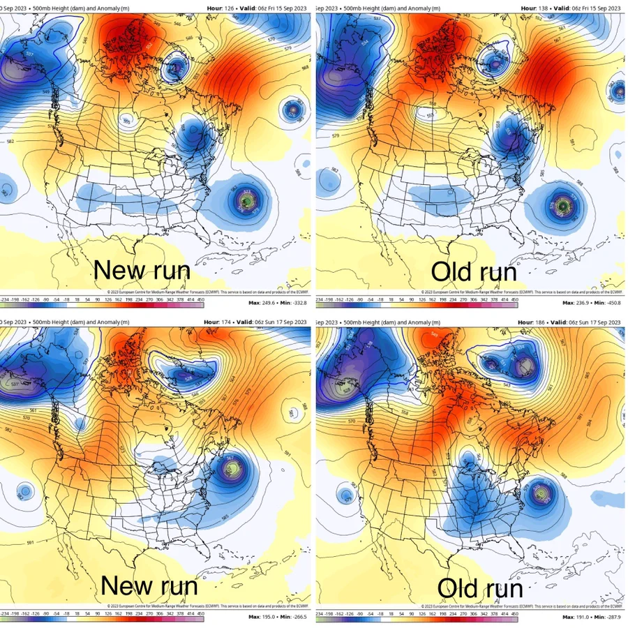
Good post, buddy. One thing I’d counter, though, is with your last graphic (height trends at H5), to me that looks like the trough is being modeled faster than it was previously rather than the ridge itself being weaker. I’m honestly not sure which interpretation is correct, though. So I’m just offering a different point of view. Otherwise, though, there’s not much else I can add haha
rb924119- Meteorologist

- Posts : 6995
Reputation : 195
Join date : 2013-02-06
Age : 32
Location : Greentown, Pa
Re: 2023 Atlantic Tropics season
![]() by rb924119 Sun Sep 10, 2023 12:02 pm
by rb924119 Sun Sep 10, 2023 12:02 pm
rb924119- Meteorologist
- Posts : 6995
Reputation : 195
Join date : 2013-02-06
Age : 32
Location : Greentown, Pa
Re: 2023 Atlantic Tropics season
![]() by rb924119 Sun Sep 10, 2023 12:13 pm
by rb924119 Sun Sep 10, 2023 12:13 pm
rb924119- Meteorologist
- Posts : 6995
Reputation : 195
Join date : 2013-02-06
Age : 32
Location : Greentown, Pa
Re: 2023 Atlantic Tropics season
![]() by rb924119 Sun Sep 10, 2023 12:14 pm
by rb924119 Sun Sep 10, 2023 12:14 pm
rb924119- Meteorologist
- Posts : 6995
Reputation : 195
Join date : 2013-02-06
Age : 32
Location : Greentown, Pa
Re: 2023 Atlantic Tropics season
![]() by sroc4 Sun Sep 10, 2023 12:28 pm
by sroc4 Sun Sep 10, 2023 12:28 pm
rb924119 wrote:sroc4 wrote:
I am taking a direct hit between the Cape and the Delmarva off the table. In fact I'm going to to say anything S of Atlantic City is off my table for a direct landfall. I am going to put a direct US Landfall, Atlantic city through eastern Maine, at a 15-30% chance of happening from west to east respectively. The trend has been for a deeper and stronger trough and a weaker N Atlantic ridge which would increase the likely hood of a recurve. Now keep in mind there is still uncertainty. These are my thoughts as of the current information available; however as we know things are subject to change should the next 2-3days trend differently that the past 2-3 days. The timing of the trough lifting out relative to the system really holds the key. The only way it lifts out before Lee gains too much latitude is if he trends to the south side of the current forecast cone as stated above.
Good post, buddy. One thing I’d counter, though, is with your last graphic (height trends at H5), to me that looks like the trough is being modeled faster than it was previously rather than the ridge itself being weaker. I’m honestly not sure which interpretation is correct, though. So I’m just offering a different point of view. Otherwise, though, there’s not much else I can add haha
Both might be correct. As far as the snap shot that I posted it is deeper and perhaps faster. Result? Ridge is weaker; however, weaker for that snapshot maybe. If it moves out faster AND/OR Lee is delayed and or further S and misses it, then its latent heat release pumps the ridge back up again in the wake of the departing trough.
Like you said the GFS just showed a similar soln to yesterdays Euro where it misses the trough, pumps the ridge in its wake leading to a more N to NNW track.
_________________
"In weather and in life, there's no winning and losing; there's only winning and learning."
WINTER 2012/2013 TOTALS 43.65"WINTER 2017/2018 TOTALS 62.85" WINTER 2022/2023 TOTALS 4.9"
WINTER 2013/2014 TOTALS 64.85"WINTER 2018/2019 TOTALS 14.25" WINTER 2023/2024 TOTALS 13.1"
WINTER 2014/2015 TOTALS 71.20"WINTER 2019/2020 TOTALS 6.35"
WINTER 2015/2016 TOTALS 35.00"WINTER 2020/2021 TOTALS 37.75"
WINTER 2016/2017 TOTALS 42.25"WINTER 2021/2022 TOTALS 31.65"
sroc4- Admin
- Posts : 8390
Reputation : 302
Join date : 2013-01-07
Location : Wading River, LI
Re: 2023 Atlantic Tropics season
![]() by jmanley32 Sun Sep 10, 2023 1:08 pm
by jmanley32 Sun Sep 10, 2023 1:08 pm
jmanley32- Senior Enthusiast
- Posts : 20593
Reputation : 108
Join date : 2013-12-12
Age : 43
Location : Yonkers, NY
Re: 2023 Atlantic Tropics season
![]() by jmanley32 Sun Sep 10, 2023 1:28 pm
by jmanley32 Sun Sep 10, 2023 1:28 pm
and i think sandy was showing that early on in models and look where she ended up. Not saying this go do same but who knows. And that windfield jeeze. Its certainly as big as sandys was or close.rb924119 wrote:FWIW 12z ICON Sandy’s into Rhode Island/Massachusetts lol at 00z it was just intonNova Scotia…..smh.
jmanley32- Senior Enthusiast
- Posts : 20593
Reputation : 108
Join date : 2013-12-12
Age : 43
Location : Yonkers, NY
Re: 2023 Atlantic Tropics season
![]() by amugs Sun Sep 10, 2023 1:51 pm
by amugs Sun Sep 10, 2023 1:51 pm
Again as echoed it is a delicate set up. Hours can mean a NW track or N NW or NNE.
_________________
Mugs
AKA:King: Snow Weenie
Self Proclaimed
WINTER 2014-15 : 55.12" +.02 for 6 coatings (avg. 35")
WINTER 2015-16 Total - 29.8" (Avg 35")
WINTER 2016-17 : 39.5" so far

amugs- Advanced Forecaster - Mod
- Posts : 15095
Reputation : 213
Join date : 2013-01-07
Age : 54
Location : Hillsdale,NJ
Re: 2023 Atlantic Tropics season
![]() by Coachgriff Sun Sep 10, 2023 2:15 pm
by Coachgriff Sun Sep 10, 2023 2:15 pm

Coachgriff- Posts : 57
Reputation : 0
Join date : 2022-01-29
amugs and GreyBeard like this post
Re: 2023 Atlantic Tropics season
![]() by GreyBeard Sun Sep 10, 2023 2:17 pm
by GreyBeard Sun Sep 10, 2023 2:17 pm


GreyBeard- Senior Enthusiast
- Posts : 725
Reputation : 34
Join date : 2014-02-12
Location : eastern nassau county
Coachgriff likes this post
Re: 2023 Atlantic Tropics season
![]() by GreyBeard Sun Sep 10, 2023 2:27 pm
by GreyBeard Sun Sep 10, 2023 2:27 pm
GreyBeard- Senior Enthusiast
- Posts : 725
Reputation : 34
Join date : 2014-02-12
Location : eastern nassau county
Re: 2023 Atlantic Tropics season
![]() by amugs Sun Sep 10, 2023 2:55 pm
by amugs Sun Sep 10, 2023 2:55 pm
All 12 Z run made a decent west jump.

_________________
Mugs
AKA:King: Snow Weenie
Self Proclaimed
WINTER 2014-15 : 55.12" +.02 for 6 coatings (avg. 35")
WINTER 2015-16 Total - 29.8" (Avg 35")
WINTER 2016-17 : 39.5" so far
amugs- Advanced Forecaster - Mod
- Posts : 15095
Reputation : 213
Join date : 2013-01-07
Age : 54
Location : Hillsdale,NJ
Re: 2023 Atlantic Tropics season
![]() by amugs Sun Sep 10, 2023 2:57 pm
by amugs Sun Sep 10, 2023 2:57 pm
All 12 Z run made a decent west jump.
_________________
Mugs
AKA:King: Snow Weenie
Self Proclaimed
WINTER 2014-15 : 55.12" +.02 for 6 coatings (avg. 35")
WINTER 2015-16 Total - 29.8" (Avg 35")
WINTER 2016-17 : 39.5" so far
amugs- Advanced Forecaster - Mod
- Posts : 15095
Reputation : 213
Join date : 2013-01-07
Age : 54
Location : Hillsdale,NJ
Re: 2023 Atlantic Tropics season
![]() by Coachgriff Sun Sep 10, 2023 3:11 pm
by Coachgriff Sun Sep 10, 2023 3:11 pm
GreyBeard wrote:Hey Coachgriff, guess I saw what you saw. Like you said, fantasyland but still...
Yeah GreyBeard….my mother is from central PA…I have heard numerous stories about Tropical Storm Agnes….this looks pretty close to a Chesapeake Bay landfall….the flooding from Agnes was epic.
Coachgriff- Posts : 57
Reputation : 0
Join date : 2022-01-29
Re: 2023 Atlantic Tropics season
![]() by jmanley32 Sun Sep 10, 2023 3:29 pm
by jmanley32 Sun Sep 10, 2023 3:29 pm

This will likely be out N storm.
jmanley32- Senior Enthusiast
- Posts : 20593
Reputation : 108
Join date : 2013-12-12
Age : 43
Location : Yonkers, NY
Re: 2023 Atlantic Tropics season
![]() by jmanley32 Sun Sep 10, 2023 3:30 pm
by jmanley32 Sun Sep 10, 2023 3:30 pm
A bunch next to jrys shore to keep us interested...Will be a long weel, what you guys thinking in terms of having a better idea when that turn happens? Wed?amugs wrote:GEFS are well west.
All 12 Z run made a decent west jump.
jmanley32- Senior Enthusiast
- Posts : 20593
Reputation : 108
Join date : 2013-12-12
Age : 43
Location : Yonkers, NY
phil155 likes this post
Re: 2023 Atlantic Tropics season
![]() by phil155 Sun Sep 10, 2023 3:42 pm
by phil155 Sun Sep 10, 2023 3:42 pm
jmanley32 wrote:Well I posted the monster to hit on 25th in banter so as not to clog up about Lee but hey, heres a closeup. Imagine if we had two direct impact hurricanes in a week of each other...
This will likely be out N storm.
I am really hoping this does not verify and I am sure we will see the models do different things over the next 2 weeks but this would be very bad. This does remind me that I need to look into a generac
phil155- Pro Enthusiast

- Posts : 487
Reputation : 4
Join date : 2019-12-16
Re: 2023 Atlantic Tropics season
![]() by Dunnzoo Sun Sep 10, 2023 3:56 pm
by Dunnzoo Sun Sep 10, 2023 3:56 pm
jmanley32 wrote:Well I posted the monster to hit on 25th in banter so as not to clog up about Lee but hey, heres a closeup. Imagine if we had two direct impact hurricanes in a week of each other...
This will likely be out N storm.
Please keep this in banter, let's concentrate on one storm at a time, this thread is going to get busier as we get closer. Thanks!
_________________
Janet
Snowfall winter of 2023-2024 17.5"
Snowfall winter of 2022-2023 6.0"
Snowfall winter of 2021-2022 17.6" 1" sleet 2/25/22
Snowfall winter of 2020-2021 51.1"
Snowfall winter of 2019-2020 8.5"
Snowfall winter of 2018-2019 25.1"
Snowfall winter of 2017-2018 51.9"
Snowfall winter of 2016-2017 45.6"
Snowfall winter of 2015-2016 29.5"
Snowfall winter of 2014-2015 50.55"
Snowfall winter of 2013-2014 66.5"

Dunnzoo- Senior Enthusiast - Mod
- Posts : 4910
Reputation : 68
Join date : 2013-01-11
Age : 62
Location : Westwood, NJ
Re: 2023 Atlantic Tropics season
![]() by amugs Sun Sep 10, 2023 3:56 pm
by amugs Sun Sep 10, 2023 3:56 pm
...And a N/NNW track toward Long Island or e. New England becomes more of a risk, as shown by the 12z GEFS. We also need to consider the possibility that #Lee's interaction with the strong jet streak to its N helps it to maintain strength instead of weakening over cooler waters pic.twitter.com/UixUd62I9I
— Yaakov Cantor (@yconsor) September 10, 2023
_________________
Mugs
AKA:King: Snow Weenie
Self Proclaimed
WINTER 2014-15 : 55.12" +.02 for 6 coatings (avg. 35")
WINTER 2015-16 Total - 29.8" (Avg 35")
WINTER 2016-17 : 39.5" so far
amugs- Advanced Forecaster - Mod
- Posts : 15095
Reputation : 213
Join date : 2013-01-07
Age : 54
Location : Hillsdale,NJ
Re: 2023 Atlantic Tropics season
![]() by jmanley32 Sun Sep 10, 2023 3:57 pm
by jmanley32 Sun Sep 10, 2023 3:57 pm
3 people posted about it above and two remarks on it why am I targeted? I did post it in banter and then saw it here above.Dunnzoo wrote:jmanley32 wrote:Well I posted the monster to hit on 25th in banter so as not to clog up about Lee but hey, heres a closeup. Imagine if we had two direct impact hurricanes in a week of each other...
This will likely be out N storm.
Please keep this in banter, let's concentrate on one storm at a time, this thread is going to get busier as we get closer. Thanks!
Last edited by jmanley32 on Sun Sep 10, 2023 4:00 pm; edited 1 time in total
jmanley32- Senior Enthusiast
- Posts : 20593
Reputation : 108
Join date : 2013-12-12
Age : 43
Location : Yonkers, NY
Coachgriff likes this post
Page 13 of 20 • 1 ... 8 ... 12, 13, 14 ... 16 ... 20 ![]()
|
|
|