
 Search
January 2024 Observations and Discussion
Page 10 of 26 •  1 ... 6 ... 9, 10, 11 ... 18 ... 26
 ![]()
Re: January 2024 Observations and Discussion
![]() by SkiSeadooJoe Mon Jan 15, 2024 8:00 am
by SkiSeadooJoe Mon Jan 15, 2024 8:00 am

SkiSeadooJoe- Posts : 93
Join date : 2013-01-08
Frank_Wx, sroc4, essexcountypete, 1190ftalt, weatherwatchermom and SENJsnowman like this post
Re: January 2024 Observations and Discussion
![]() by weatherwatchermom Mon Jan 15, 2024 9:23 am
by weatherwatchermom Mon Jan 15, 2024 9:23 am
weatherwatchermom- Senior Enthusiast

- Posts : 3829
Join date : 2014-11-25
1190ftalt likes this post
Re: January 2024 Observations and Discussion
![]() by docstox12 Mon Jan 15, 2024 1:45 pm
by docstox12 Mon Jan 15, 2024 1:45 pm

docstox12- Wx Statistician Guru

- Posts : 8560
Reputation : 222
Join date : 2013-01-07
Age : 73
Location : Monroe NY
Re: January 2024 Observations and Discussion
![]() by SkiSeadooJoe Mon Jan 15, 2024 3:35 pm
by SkiSeadooJoe Mon Jan 15, 2024 3:35 pm

SkiSeadooJoe- Posts : 93
Reputation : 8
Join date : 2013-01-08
Age : 51
Location : Toms River, NJ
kalleg, 1190ftalt, heehaw453 and SENJsnowman like this post
Re: January 2024 Observations and Discussion
![]() by docstox12 Mon Jan 15, 2024 3:47 pm
by docstox12 Mon Jan 15, 2024 3:47 pm
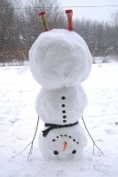
SkiSeadooJoe wrote:I'm ready to measure even if its just a few inches. But ut oh....look closely in my mulch...spring has sprung already
Hey Joe, that spring scene will be a winter one shortly! Send us a photo tomorrow for comparison.Hope all the Shore and LI Crew gets a nice snowpack from this!
27 degrees, thick grey Stratus snow clouds, calm wind.
docstox12- Wx Statistician Guru
- Posts : 8560
Reputation : 222
Join date : 2013-01-07
Age : 73
Location : Monroe NY
SkiSeadooJoe, 1190ftalt and SENJsnowman like this post
Re: January 2024 Observations and Discussion
![]() by dkodgis Mon Jan 15, 2024 4:04 pm
by dkodgis Mon Jan 15, 2024 4:04 pm

dkodgis- Senior Enthusiast
- Posts : 2622
Reputation : 98
Join date : 2013-12-29
Re: January 2024 Observations and Discussion
![]() by amugs Mon Jan 15, 2024 4:10 pm
by amugs Mon Jan 15, 2024 4:10 pm
Do not count out Thursday/Friday storm - look what happened with todays. Case in point and NW trends all winter long
_________________
Mugs
AKA:King: Snow Weenie
Self Proclaimed
WINTER 2014-15 : 55.12" +.02 for 6 coatings (avg. 35")
WINTER 2015-16 Total - 29.8" (Avg 35")
WINTER 2016-17 : 39.5" so far

amugs- Advanced Forecaster - Mod

- Posts : 15095
Reputation : 213
Join date : 2013-01-07
Age : 54
Location : Hillsdale,NJ
kalleg, 1190ftalt, heehaw453 and SENJsnowman like this post
Re: January 2024 Observations and Discussion
![]() by billg315 Mon Jan 15, 2024 4:37 pm
by billg315 Mon Jan 15, 2024 4:37 pm

billg315- Advanced Forecaster - Mod
- Posts : 4515
Reputation : 185
Join date : 2015-01-24
Age : 50
Location : Flemington, NJ
Re: January 2024 Observations and Discussion
![]() by SENJsnowman Mon Jan 15, 2024 4:39 pm
by SENJsnowman Mon Jan 15, 2024 4:39 pm
SkiSeadooJoe wrote:I'm ready to measure even if its just a few inches. But ut oh....look closely in my mulch...spring has sprung already
Wow Joe did your pic ever bring some happy memories!
The before and the beautiful after from Jan 29, ‘22.


C’mon Shore, let’s show our heart and overachieve tonight! Or better yet, how about a prelude for Friday!!
Small sparse flakes, 28* and grey skies right now. Radar looks like it’s not sure if it wants to fill in over Central Jersey now or wait until later this evening.
SENJsnowman- Senior Enthusiast
- Posts : 1189
Reputation : 61
Join date : 2017-01-06
Age : 51
Location : Bayville, NJ
SkiSeadooJoe, kalleg and heehaw453 like this post
Re: January 2024 Observations and Discussion
![]() by kalleg Mon Jan 15, 2024 8:21 pm
by kalleg Mon Jan 15, 2024 8:21 pm
kalleg- Posts : 156
Reputation : 2
Join date : 2013-01-15
Location : New Hope, PA
SENJsnowman likes this post
Re: January 2024 Observations and Discussion
![]() by dkodgis Wed Jan 17, 2024 7:46 am
by dkodgis Wed Jan 17, 2024 7:46 am
Any snow not shoveled nor removed, frozen. What’s left is not pretty either to walk on
dkodgis- Senior Enthusiast
- Posts : 2622
Reputation : 98
Join date : 2013-12-29
Re: January 2024 Observations and Discussion
![]() by sroc4 Wed Jan 17, 2024 8:07 am
by sroc4 Wed Jan 17, 2024 8:07 am

Its looking like this Fridays system is going to be a minor event at best. There is def an Inverted Trough(IVT) signature for sure, but the full details of IVT's can be extremely diff to forecast even as it unfolds let alone at this lead time. Quite honestly they are often times now cast situations where surprises aren't uncommon.
This is also looking like a very high ratio snow event too, so even minor bumps up in QPF can have meaningful impacts. anywhere from 15:1-25:1 ratios I think are likely depending on your exact location.
There is no doubt that additional shifts to exact set up and track of the primary Low and IVT, etc. are still possible and Id argue likely, for better OR worse, so hang tight on throwing in towels yet. If you see 20-25:1 ratios but only get 0.1" of QPF that's still 2-2.5" of nice light fluffy snow accumulation. Keep that in mind today.
Here are a few of the global and short range models and their current total QPF forecasts for this event.


_________________
"In weather and in life, there's no winning and losing; there's only winning and learning."
WINTER 2012/2013 TOTALS 43.65"WINTER 2017/2018 TOTALS 62.85" WINTER 2022/2023 TOTALS 4.9"
WINTER 2013/2014 TOTALS 64.85"WINTER 2018/2019 TOTALS 14.25" WINTER 2023/2024 TOTALS 13.1"
WINTER 2014/2015 TOTALS 71.20"WINTER 2019/2020 TOTALS 6.35"
WINTER 2015/2016 TOTALS 35.00"WINTER 2020/2021 TOTALS 37.75"
WINTER 2016/2017 TOTALS 42.25"WINTER 2021/2022 TOTALS 31.65"

sroc4- Admin

- Posts : 8394
Reputation : 302
Join date : 2013-01-07
Location : Wading River, LI
kalleg, oldtimer, essexcountypete, weatherwatchermom and silentwreck like this post
Re: January 2024 Observations and Discussion
![]() by Frank_Wx Wed Jan 17, 2024 8:14 am
by Frank_Wx Wed Jan 17, 2024 8:14 am
_________________
_______________________________________________________________________________________________________
CLICK HERE to view NJ Strong Snowstorm Classifications

Frank_Wx- Godzilla Seeker
- Posts : 21305
Reputation : 328
Join date : 2013-01-05
Age : 32
Location : Jersey City, NJ -

kalleg, oldtimer, jmanley32, 1190ftalt, weatherwatchermom and silentwreck like this post
Re: January 2024 Observations and Discussion
![]() by weatherwatchermom Wed Jan 17, 2024 8:15 am
by weatherwatchermom Wed Jan 17, 2024 8:15 am

weatherwatchermom- Senior Enthusiast
- Posts : 3829
Reputation : 78
Join date : 2014-11-25
Location : Hazlet Township, NJ
sroc4, 1190ftalt and SENJsnowman like this post
Re: January 2024 Observations and Discussion
![]() by 1190ftalt Wed Jan 17, 2024 8:26 am
by 1190ftalt Wed Jan 17, 2024 8:26 am
Good Luck !


1190ftalt- Pro Enthusiast

- Posts : 402
Reputation : 10
Join date : 2013-12-13
Location : Stillwater, NJ
sroc4 and weatherwatchermom like this post
Re: January 2024 Observations and Discussion
![]() by heehaw453 Wed Jan 17, 2024 8:59 am
by heehaw453 Wed Jan 17, 2024 8:59 am
heehaw453- Advanced Forecaster

- Posts : 3906
Reputation : 86
Join date : 2014-01-20
Location : Bedminster Township, PA Elevation 600' ASL
Re: January 2024 Observations and Discussion
![]() by amugs Wed Jan 17, 2024 10:52 am
by amugs Wed Jan 17, 2024 10:52 am
_________________
Mugs
AKA:King: Snow Weenie
Self Proclaimed
WINTER 2014-15 : 55.12" +.02 for 6 coatings (avg. 35")
WINTER 2015-16 Total - 29.8" (Avg 35")
WINTER 2016-17 : 39.5" so far
amugs- Advanced Forecaster - Mod
- Posts : 15095
Reputation : 213
Join date : 2013-01-07
Age : 54
Location : Hillsdale,NJ
Re: January 2024 Observations and Discussion
![]() by billg315 Wed Jan 17, 2024 11:00 am
by billg315 Wed Jan 17, 2024 11:00 am
With the snow covered ground if we have clear skies tonight could see it getting into the single digits but it looks like some cloud cover may move in late which will likely keep temps in the low teens tonight.
billg315- Advanced Forecaster - Mod
- Posts : 4515
Reputation : 185
Join date : 2015-01-24
Age : 50
Location : Flemington, NJ
Re: January 2024 Observations and Discussion
![]() by heehaw453 Wed Jan 17, 2024 11:05 am
by heehaw453 Wed Jan 17, 2024 11:05 am

heehaw453- Advanced Forecaster
- Posts : 3906
Reputation : 86
Join date : 2014-01-20
Location : Bedminster Township, PA Elevation 600' ASL
Re: January 2024 Observations and Discussion
![]() by billg315 Wed Jan 17, 2024 11:06 am
by billg315 Wed Jan 17, 2024 11:06 am
billg315- Advanced Forecaster - Mod
- Posts : 4515
Reputation : 185
Join date : 2015-01-24
Age : 50
Location : Flemington, NJ
Re: January 2024 Observations and Discussion
![]() by amugs Wed Jan 17, 2024 11:08 am
by amugs Wed Jan 17, 2024 11:08 am
A would assume a NW jog with this system due to the weather memory of pattern and storm tracks the past 2 months as everything has ticked NW.
NAM is most likely overdone with the QPF but the RGEM has had the better handle on our last few snowstorms. The NAM's though have sniffed out the warm nose in the last two so you have to know how to use each model for it strengths.
12Z GFS and RGEM have cut back on precip amounts
GFS

RGEM

Still 20:1 ration are for .15" a 3" snowfall if it verifies as such
15:1 is 2.5"
10:1 is 1.5"
As long as none is lost to Virga!!! The next most dreaded wintertime hex mechanism to SUBSIDENCE!!
_________________
Mugs
AKA:King: Snow Weenie
Self Proclaimed
WINTER 2014-15 : 55.12" +.02 for 6 coatings (avg. 35")
WINTER 2015-16 Total - 29.8" (Avg 35")
WINTER 2016-17 : 39.5" so far
amugs- Advanced Forecaster - Mod
- Posts : 15095
Reputation : 213
Join date : 2013-01-07
Age : 54
Location : Hillsdale,NJ
Re: January 2024 Observations and Discussion
![]() by jmanley32 Wed Jan 17, 2024 11:19 am
by jmanley32 Wed Jan 17, 2024 11:19 am
that would b nuts. 0.6+ could be a godzilla wouldnt that be something uncommon. Will the high ratios hold for nyc area too? I am not put my expectations that high but 3 to 4 or 3 to 6 would be a decent storm a few inches ill even take.Frank_Wx wrote:0.5” qpf could be 10” of snow
Last edited by jmanley32 on Wed Jan 17, 2024 11:22 am; edited 1 time in total

jmanley32- Senior Enthusiast
- Posts : 20595
Reputation : 108
Join date : 2013-12-12
Age : 43
Location : Yonkers, NY
Re: January 2024 Observations and Discussion
![]() by jmanley32 Wed Jan 17, 2024 11:20 am
by jmanley32 Wed Jan 17, 2024 11:20 am
is that at 10:1 or taking into consideration higher ratios.heehaw453 wrote:Hot off the presses WPC 15Z issued. Focusing on central & NE NJ/NYC. 40-50% chance of at least 4" of snow. Based on the ULL pass that's probably a good of area as any.
jmanley32- Senior Enthusiast
- Posts : 20595
Reputation : 108
Join date : 2013-12-12
Age : 43
Location : Yonkers, NY
Re: January 2024 Observations and Discussion
![]() by amugs Wed Jan 17, 2024 11:21 am
by amugs Wed Jan 17, 2024 11:21 am

_________________
Mugs
AKA:King: Snow Weenie
Self Proclaimed
WINTER 2014-15 : 55.12" +.02 for 6 coatings (avg. 35")
WINTER 2015-16 Total - 29.8" (Avg 35")
WINTER 2016-17 : 39.5" so far
amugs- Advanced Forecaster - Mod
- Posts : 15095
Reputation : 213
Join date : 2013-01-07
Age : 54
Location : Hillsdale,NJ
jmanley32 likes this post
Re: January 2024 Observations and Discussion
![]() by sroc4 Wed Jan 17, 2024 11:22 am
by sroc4 Wed Jan 17, 2024 11:22 am
For those who want to see it the IVT is the kink in the contours to the isobars outlined in the thick black lines. The axis is highlighted in yellow, and the precip shield as you can see extends well west from where the center of the Primary LP center is, which in this image is all the way in the middle right side of the image. Again the exact shape of the contours and the axis of etc all dictate the details. These thing s can, but not always, overperform very very easily, esp with high ratios.

_________________
"In weather and in life, there's no winning and losing; there's only winning and learning."
WINTER 2012/2013 TOTALS 43.65"WINTER 2017/2018 TOTALS 62.85" WINTER 2022/2023 TOTALS 4.9"
WINTER 2013/2014 TOTALS 64.85"WINTER 2018/2019 TOTALS 14.25" WINTER 2023/2024 TOTALS 13.1"
WINTER 2014/2015 TOTALS 71.20"WINTER 2019/2020 TOTALS 6.35"
WINTER 2015/2016 TOTALS 35.00"WINTER 2020/2021 TOTALS 37.75"
WINTER 2016/2017 TOTALS 42.25"WINTER 2021/2022 TOTALS 31.65"
sroc4- Admin
- Posts : 8394
Reputation : 302
Join date : 2013-01-07
Location : Wading River, LI
kalleg, jmanley32 and phil155 like this post
Re: January 2024 Observations and Discussion
![]() by heehaw453 Wed Jan 17, 2024 11:32 am
by heehaw453 Wed Jan 17, 2024 11:32 am
That's an attention getter...
heehaw453- Advanced Forecaster
- Posts : 3906
Reputation : 86
Join date : 2014-01-20
Location : Bedminster Township, PA Elevation 600' ASL
sroc4, amugs and jmanley32 like this post
Re: January 2024 Observations and Discussion
![]() by heehaw453 Wed Jan 17, 2024 11:33 am
by heehaw453 Wed Jan 17, 2024 11:33 am
sroc4 wrote:Yes Mugs you used the dreaded word Virga which I wasn't going to bring up until later tomorrow. lol
For those who want to see it the IVT is the kink in the contours to the isobars outlined in the thick black lines. The axis is highlighted in yellow, and the precip shield as you can see extends well west from where the center of the Primary LP center is, which in this image is all the way in the middle right side of the image. Again the exact shape of the contours and the axis of etc all dictate the details. These thing s can, but not always, overperform very very easily, esp with high ratios.
That's indicative of a strengthening ULL. Good things, good things.
heehaw453- Advanced Forecaster
- Posts : 3906
Reputation : 86
Join date : 2014-01-20
Location : Bedminster Township, PA Elevation 600' ASL
sroc4, jmanley32 and richb521 like this post
Page 10 of 26 • 1 ... 6 ... 9, 10, 11 ... 18 ... 26 ![]()
|
|
|