
 Search
January 2024 Observations and Discussion
Page 11 of 26 •  1 ... 7 ... 10, 11, 12 ... 18 ... 26
 ![]()
Re: January 2024 Observations and Discussion
![]() by heehaw453 Wed Jan 17, 2024 11:32 am
by heehaw453 Wed Jan 17, 2024 11:32 am
That's an attention getter...
heehaw453- Advanced Forecaster

- Posts : 3906
Join date : 2014-01-20
sroc4, amugs and jmanley32 like this post
Re: January 2024 Observations and Discussion
![]() by heehaw453 Wed Jan 17, 2024 11:33 am
by heehaw453 Wed Jan 17, 2024 11:33 am
sroc4 wrote:Yes Mugs you used the dreaded word Virga which I wasn't going to bring up until later tomorrow. lol
For those who want to see it the IVT is the kink in the contours to the isobars outlined in the thick black lines. The axis is highlighted in yellow, and the precip shield as you can see extends well west from where the center of the Primary LP center is, which in this image is all the way in the middle right side of the image. Again the exact shape of the contours and the axis of etc all dictate the details. These thing s can, but not always, overperform very very easily, esp with high ratios.

That's indicative of a strengthening ULL. Good things, good things.
heehaw453- Advanced Forecaster
- Posts : 3906
Join date : 2014-01-20
sroc4, jmanley32 and richb521 like this post
Re: January 2024 Observations and Discussion
![]() by heehaw453 Wed Jan 17, 2024 11:47 am
by heehaw453 Wed Jan 17, 2024 11:47 am
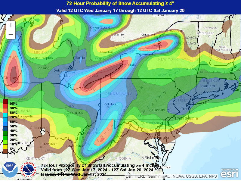
jmanley32 wrote:is that at 10:1 or taking into consideration higher ratios.heehaw453 wrote:Hot off the presses WPC 15Z issued. Focusing on central & NE NJ/NYC. 40-50% chance of at least 4" of snow. Based on the ULL pass that's probably a good of area as any.

That's a good question. Not sure it's accounting for ratios on that. Certainly though with -12c h7 temps ratios could be 15:1 or better.
heehaw453- Advanced Forecaster
- Posts : 3906
Reputation : 86
Join date : 2014-01-20
Location : Bedminster Township, PA Elevation 600' ASL
Re: January 2024 Observations and Discussion
![]() by SENJsnowman Wed Jan 17, 2024 11:48 am
by SENJsnowman Wed Jan 17, 2024 11:48 am
As a Jersey Shorite, all I can say to these last few posts by Mugs, SRoc and HeeHaw is
For those who wish to join me in (light-hearted) prayer:
The favorable trends for the Shore and other areas should increase, and not decrease; the precip shield should expand throughout the forum and not contract; the ULL should strengthen earlier and not later; and there should be no show killers, like Virga or Subsidence to deprive of us of His heavenly bounty.
Can I get an Amen?!
SENJsnowman- Senior Enthusiast

- Posts : 1189
Reputation : 61
Join date : 2017-01-06
Age : 51
Location : Bayville, NJ
Frank_Wx, docstox12, CPcantmeasuresnow, kalleg, Grselig, jmanley32, richb521 and like this post
Re: January 2024 Observations and Discussion
![]() by Frank_Wx Wed Jan 17, 2024 12:07 pm
by Frank_Wx Wed Jan 17, 2024 12:07 pm
_________________
_______________________________________________________________________________________________________
CLICK HERE to view NJ Strong Snowstorm Classifications

Frank_Wx- Godzilla Seeker

- Posts : 21305
Reputation : 328
Join date : 2013-01-05
Age : 32
Location : Jersey City, NJ -

Re: January 2024 Observations and Discussion
![]() by amugs Wed Jan 17, 2024 1:01 pm
by amugs Wed Jan 17, 2024 1:01 pm
Frank_Wx wrote:If I had to place a bet - and I must be crazy since IVTs are mostly unpredictable - I would place SNJ in the jackpot for this one. 2-4” as much as 6”
This is where you may puke snow at this time in the black circle. It can all change in the next set of runs . Norluns love to move N from experience and it usually does but time will tel.

_________________
Mugs
AKA:King: Snow Weenie
Self Proclaimed
WINTER 2014-15 : 55.12" +.02 for 6 coatings (avg. 35")
WINTER 2015-16 Total - 29.8" (Avg 35")
WINTER 2016-17 : 39.5" so far

amugs- Advanced Forecaster - Mod

- Posts : 15095
Reputation : 213
Join date : 2013-01-07
Age : 54
Location : Hillsdale,NJ
Re: January 2024 Observations and Discussion
![]() by amugs Wed Jan 17, 2024 1:10 pm
by amugs Wed Jan 17, 2024 1:10 pm


Its the new experimental model as explained:
Rapid Refresh Forecast System
GSL, NCEP/EMC, and other partners are working together on a project to design a single-model, convection-allowing, ensemble-based data assimilation, and forecasting system called the Rapid Refresh Forecast System (RRFS).
Within the NOAA model unification effort, the RRFS represents the evolution of the NAM, RAP, HRRR, and HREF systems to a new unified deterministic and ensemble storm-scale system. This new system is targeted for initial operational implementation in late 2024 as a planned replacement for the NAMnest, HRRR, HiResWindows, and HREF.
_________________
Mugs
AKA:King: Snow Weenie
Self Proclaimed
WINTER 2014-15 : 55.12" +.02 for 6 coatings (avg. 35")
WINTER 2015-16 Total - 29.8" (Avg 35")
WINTER 2016-17 : 39.5" so far
amugs- Advanced Forecaster - Mod
- Posts : 15095
Reputation : 213
Join date : 2013-01-07
Age : 54
Location : Hillsdale,NJ
Re: January 2024 Observations and Discussion
![]() by heehaw453 Wed Jan 17, 2024 1:16 pm
by heehaw453 Wed Jan 17, 2024 1:16 pm

heehaw453- Advanced Forecaster
- Posts : 3906
Reputation : 86
Join date : 2014-01-20
Location : Bedminster Township, PA Elevation 600' ASL
Re: January 2024 Observations and Discussion
![]() by tomsriversnowstorm Wed Jan 17, 2024 1:18 pm
by tomsriversnowstorm Wed Jan 17, 2024 1:18 pm
heehaw453 wrote:The main reason we don't see a closed off ULL with this is the spacing issues discussed before. There's not clean separation between the waves. It's like putting half a cover over a fire. It's really the only thing IMO that prevents this from being an sig event. If somehow that improves you'd see a closed off ULL and this dropping major accumulations.
tomsriversnowstorm- Posts : 90
Reputation : 0
Join date : 2021-02-06
Re: January 2024 Observations and Discussion
![]() by aiannone Wed Jan 17, 2024 1:20 pm
by aiannone Wed Jan 17, 2024 1:20 pm

_________________
-Alex Iannone-

aiannone- Senior Enthusiast - Mod
- Posts : 4819
Reputation : 92
Join date : 2013-01-07
Location : Saint James, LI (Northwest Suffolk Co.)
Re: January 2024 Observations and Discussion
![]() by heehaw453 Wed Jan 17, 2024 1:26 pm
by heehaw453 Wed Jan 17, 2024 1:26 pm
tomsriversnowstorm wrote:Is there any chance that can happen?heehaw453 wrote:The main reason we don't see a closed off ULL with this is the spacing issues discussed before. There's not clean separation between the waves. It's like putting half a cover over a fire. It's really the only thing IMO that prevents this from being an sig event. If somehow that improves you'd see a closed off ULL and this dropping major accumulations.
I don't think clean spacing is in the cards per se, so there's a cap on potential IMO
2 things come to mind to possibly push this to 5-6", 1/inverted trough enhancement, 2/the ULL strengthens earlier due to better phasing. and these are not mutually exclusive.
heehaw453- Advanced Forecaster
- Posts : 3906
Reputation : 86
Join date : 2014-01-20
Location : Bedminster Township, PA Elevation 600' ASL
Re: January 2024 Observations and Discussion
![]() by sroc4 Wed Jan 17, 2024 1:32 pm
by sroc4 Wed Jan 17, 2024 1:32 pm
_________________
"In weather and in life, there's no winning and losing; there's only winning and learning."
WINTER 2012/2013 TOTALS 43.65"WINTER 2017/2018 TOTALS 62.85" WINTER 2022/2023 TOTALS 4.9"
WINTER 2013/2014 TOTALS 64.85"WINTER 2018/2019 TOTALS 14.25" WINTER 2023/2024 TOTALS 13.1"
WINTER 2014/2015 TOTALS 71.20"WINTER 2019/2020 TOTALS 6.35"
WINTER 2015/2016 TOTALS 35.00"WINTER 2020/2021 TOTALS 37.75"
WINTER 2016/2017 TOTALS 42.25"WINTER 2021/2022 TOTALS 31.65"

sroc4- Admin
- Posts : 8394
Reputation : 302
Join date : 2013-01-07
Location : Wading River, LI
Re: January 2024 Observations and Discussion
![]() by heehaw453 Wed Jan 17, 2024 1:39 pm
by heehaw453 Wed Jan 17, 2024 1:39 pm
Could also be there are several main pieces of energy that don't merge. That certainly doesn't help, but I think that wouldn't be a problem if heights weren't getting dampened by the wave in front. It's hard to tilt negative and close off when something is pressing on its ability to do so.sroc4 wrote:Euro is almost a big fat nothing burger. It more than just wave spacing as to why it stays flat and progressive. To me this is a big red flag. Ill give this to the morning.
heehaw453- Advanced Forecaster
- Posts : 3906
Reputation : 86
Join date : 2014-01-20
Location : Bedminster Township, PA Elevation 600' ASL
sroc4 likes this post
Re: January 2024 Observations and Discussion
![]() by heehaw453 Wed Jan 17, 2024 1:41 pm
by heehaw453 Wed Jan 17, 2024 1:41 pm
heehaw453- Advanced Forecaster
- Posts : 3906
Reputation : 86
Join date : 2014-01-20
Location : Bedminster Township, PA Elevation 600' ASL
Re: January 2024 Observations and Discussion
![]() by phil155 Wed Jan 17, 2024 1:47 pm
by phil155 Wed Jan 17, 2024 1:47 pm
heehaw453 wrote:And like I was saying was before I think 1-3" is an excellent expectations setter. Could over perform but I think synoptically that range is appropriate.
Agree 100%
phil155- Pro Enthusiast

- Posts : 487
Reputation : 4
Join date : 2019-12-16
Re: January 2024 Observations and Discussion
![]() by heehaw453 Wed Jan 17, 2024 2:04 pm
by heehaw453 Wed Jan 17, 2024 2:04 pm

heehaw453- Advanced Forecaster
- Posts : 3906
Reputation : 86
Join date : 2014-01-20
Location : Bedminster Township, PA Elevation 600' ASL
Re: January 2024 Observations and Discussion
![]() by jmanley32 Wed Jan 17, 2024 2:21 pm
by jmanley32 Wed Jan 17, 2024 2:21 pm
Last edited by jmanley32 on Wed Jan 17, 2024 2:25 pm; edited 1 time in total

jmanley32- Senior Enthusiast
- Posts : 20595
Reputation : 108
Join date : 2013-12-12
Age : 43
Location : Yonkers, NY
Re: January 2024 Observations and Discussion
![]() by CPcantmeasuresnow Wed Jan 17, 2024 2:24 pm
by CPcantmeasuresnow Wed Jan 17, 2024 2:24 pm
aiannone wrote:12z EURO is UGGGLYYY...
Where's the dislike button? Not for Alex but definitely for the Euro.

CPcantmeasuresnow- Wx Statistician Guru

- Posts : 7274
Reputation : 230
Join date : 2013-01-07
Age : 103
Location : Eastern Orange County, NY
Re: January 2024 Observations and Discussion
![]() by Dunnzoo Wed Jan 17, 2024 2:25 pm
by Dunnzoo Wed Jan 17, 2024 2:25 pm

_________________
Janet
Snowfall winter of 2023-2024 17.5"
Snowfall winter of 2022-2023 6.0"
Snowfall winter of 2021-2022 17.6" 1" sleet 2/25/22
Snowfall winter of 2020-2021 51.1"
Snowfall winter of 2019-2020 8.5"
Snowfall winter of 2018-2019 25.1"
Snowfall winter of 2017-2018 51.9"
Snowfall winter of 2016-2017 45.6"
Snowfall winter of 2015-2016 29.5"
Snowfall winter of 2014-2015 50.55"
Snowfall winter of 2013-2014 66.5"

Dunnzoo- Senior Enthusiast - Mod
- Posts : 4912
Reputation : 68
Join date : 2013-01-11
Age : 62
Location : Westwood, NJ
jmanley32 likes this post
Re: January 2024 Observations and Discussion
![]() by sroc4 Wed Jan 17, 2024 2:27 pm
by sroc4 Wed Jan 17, 2024 2:27 pm
heehaw453 wrote:Could also be there are several main pieces of energy that don't merge. That certainly doesn't help, but I think that wouldn't be a problem if heights weren't getting dampened by the wave in front. It's hard to tilt negative and close off when something is pressing on its ability to do so.sroc4 wrote:Euro is almost a big fat nothing burger. It more than just wave spacing as to why it stays flat and progressive. To me this is a big red flag. Ill give this to the morning.
Yes but equally important is the pna ridge. It’s just not steep enough. It’s axis is way to slanted from NW at its apex to SE on its eastern flank. This also does not allow any northern stream energy to dig into or even create really any real trough. It just kind of slips into the back side and stays progressive. I think if the ridge axis was ironed better in the N S direction it would dig causing some consolidation of energy which in turn would challenge the wave spacing idea. Personally it appears we have both working against. And I agree on your totals as again a very low amount of QPF will lead to quick accumulations. This just has so much potential if we could have gotten just a little help from the western side of things.
_________________
"In weather and in life, there's no winning and losing; there's only winning and learning."
WINTER 2012/2013 TOTALS 43.65"WINTER 2017/2018 TOTALS 62.85" WINTER 2022/2023 TOTALS 4.9"
WINTER 2013/2014 TOTALS 64.85"WINTER 2018/2019 TOTALS 14.25" WINTER 2023/2024 TOTALS 13.1"
WINTER 2014/2015 TOTALS 71.20"WINTER 2019/2020 TOTALS 6.35"
WINTER 2015/2016 TOTALS 35.00"WINTER 2020/2021 TOTALS 37.75"
WINTER 2016/2017 TOTALS 42.25"WINTER 2021/2022 TOTALS 31.65"
sroc4- Admin
- Posts : 8394
Reputation : 302
Join date : 2013-01-07
Location : Wading River, LI
heehaw453 likes this post
Re: January 2024 Observations and Discussion
![]() by sroc4 Wed Jan 17, 2024 2:28 pm
by sroc4 Wed Jan 17, 2024 2:28 pm
_________________
"In weather and in life, there's no winning and losing; there's only winning and learning."
WINTER 2012/2013 TOTALS 43.65"WINTER 2017/2018 TOTALS 62.85" WINTER 2022/2023 TOTALS 4.9"
WINTER 2013/2014 TOTALS 64.85"WINTER 2018/2019 TOTALS 14.25" WINTER 2023/2024 TOTALS 13.1"
WINTER 2014/2015 TOTALS 71.20"WINTER 2019/2020 TOTALS 6.35"
WINTER 2015/2016 TOTALS 35.00"WINTER 2020/2021 TOTALS 37.75"
WINTER 2016/2017 TOTALS 42.25"WINTER 2021/2022 TOTALS 31.65"
sroc4- Admin
- Posts : 8394
Reputation : 302
Join date : 2013-01-07
Location : Wading River, LI
jmanley32 and heehaw453 like this post
Re: January 2024 Observations and Discussion
![]() by docstox12 Wed Jan 17, 2024 2:42 pm
by docstox12 Wed Jan 17, 2024 2:42 pm
heehaw453 wrote:Mount Holly's latest snowfall prog. 3" to increase snowpack works for me. we'll see.
22 degrees, partly cloudy, breezy.
Nice to see 3 inch totals on this map! That would be great for our snowpacks and with the cold coming in, we will have them until Weds.

docstox12- Wx Statistician Guru
- Posts : 8560
Reputation : 222
Join date : 2013-01-07
Age : 73
Location : Monroe NY
Re: January 2024 Observations and Discussion
![]() by SENJsnowman Wed Jan 17, 2024 2:48 pm
by SENJsnowman Wed Jan 17, 2024 2:48 pm
heehaw453 wrote:Mount Holly's latest snowfall prog. 3" to increase snowpack works for me. we'll see.
Hmmm
SENJsnowman- Senior Enthusiast
- Posts : 1189
Reputation : 61
Join date : 2017-01-06
Age : 51
Location : Bayville, NJ
Re: January 2024 Observations and Discussion
![]() by richb521 Wed Jan 17, 2024 2:53 pm
by richb521 Wed Jan 17, 2024 2:53 pm
docstox12 wrote:heehaw453 wrote:Mount Holly's latest snowfall prog. 3" to increase snowpack works for me. we'll see.
22 degrees, partly cloudy, breezy.
Nice to see 3 inch totals on this map! That would be great for our snowpacks and with the cold coming in, we will have them until Weds.
This would work for me as well. To have a snowpack for almost an entire week would be the best we’ve had in at least 2 years.
richb521- Posts : 61
Reputation : 3
Join date : 2014-01-19
Age : 50
Location : Hillsborough, NJ
heehaw453 likes this post
Re: January 2024 Observations and Discussion
![]() by amugs Wed Jan 17, 2024 3:02 pm
by amugs Wed Jan 17, 2024 3:02 pm
They smocking some good stuff or are teh onto something using the newest guidance model I posted earlier.
_________________
Mugs
AKA:King: Snow Weenie
Self Proclaimed
WINTER 2014-15 : 55.12" +.02 for 6 coatings (avg. 35")
WINTER 2015-16 Total - 29.8" (Avg 35")
WINTER 2016-17 : 39.5" so far
amugs- Advanced Forecaster - Mod
- Posts : 15095
Reputation : 213
Join date : 2013-01-07
Age : 54
Location : Hillsdale,NJ
Grselig and jmanley32 like this post
Re: January 2024 Observations and Discussion
![]() by heehaw453 Wed Jan 17, 2024 3:13 pm
by heehaw453 Wed Jan 17, 2024 3:13 pm
amugs wrote:WPC moved the NORLUN over the NYC Metro ala NOV 2018.
They smocking some good stuff or are teh onto something using the newest guidance model I posted earlier.
It's changed 18Z. Ingested the Euro data. LoL

heehaw453- Advanced Forecaster
- Posts : 3906
Reputation : 86
Join date : 2014-01-20
Location : Bedminster Township, PA Elevation 600' ASL
Re: January 2024 Observations and Discussion
![]() by heehaw453 Wed Jan 17, 2024 4:03 pm
by heehaw453 Wed Jan 17, 2024 4:03 pm
RGENT - WINTER WEATHER MESSAGE
National Weather Service Mount Holly NJ
316 PM EST Wed Jan 17 2024
NJZ001-007>010-012>015-PAZ054-055-060>062-103-105-181100-
/O.NEW.KPHI.WW.Y.0003.240119T0500Z-240120T0000Z/
Sussex-Warren-Morris-Hunterdon-Somerset-Middlesex-
Western Monmouth-Eastern Monmouth-Mercer-Carbon-Monroe-Berks-
Lehigh-Northampton-Western Montgomery-Upper Bucks-
Including the cities of Newton, Washington, Morristown,
Flemington, Somerville, New Brunswick, Freehold, Sandy Hook,
Trenton, Jim Thorpe, Stroudsburg, Reading, Allentown, Bethlehem,
Easton, Collegeville, Pottstown, Chalfont, and Perkasie
316 PM EST Wed Jan 17 2024
...WINTER WEATHER ADVISORY IN EFFECT FROM MIDNIGHT THURSDAY NIGHT
TO 7 PM EST FRIDAY...
* WHAT...Snow expected. Total snow accumulations of 2 to 4
inches.
* WHERE...Portions of central, northern and northwest New Jersey
and east central, northeast and southeast Pennsylvania.
* WHEN...From midnight Thursday night to 7 PM EST Friday.
* IMPACTS...Plan on slippery road conditions. The hazardous
conditions could impact the morning or evening commute.
* ADDITIONAL DETAILS...Temperatures will rapidly drop into the
teens late Friday night. Any untreated roads will become icy and
dangerous.
PRECAUTIONARY/PREPAREDNESS ACTIONS...
Slow down and use caution while traveling.
The latest road conditions for the state you are calling from can
be obtained by calling 5 1 1.
heehaw453- Advanced Forecaster
- Posts : 3906
Reputation : 86
Join date : 2014-01-20
Location : Bedminster Township, PA Elevation 600' ASL
Page 11 of 26 • 1 ... 7 ... 10, 11, 12 ... 18 ... 26 ![]()
|
|
|