Long Range Thread 8.0
+30
Grselig
devsman
chief7
oldtimer
Noreaster
Quietace
mako460
jimv45
rb924119
sroc4
HectorO
snow247
essexcountypete
chinkaps
billg315
Snow88
dkodgis
docstox12
WOLVES1
nutleyblizzard
CPcantmeasuresnow
algae888
skinsfan1177
Dunnzoo
weatherwatchermom
Math23x7
jmanley32
amugs
Dtone
Frank_Wx
34 posters
Page 19 of 40
Page 19 of 40 •  1 ... 11 ... 18, 19, 20 ... 29 ... 40
 Re: Long Range Thread 8.0
Scott, never understood these dots for what they mean - looks like the chicken pox to me !!sroc4 wrote:Here are the anomalies/departures from normal.
amugs- Advanced Forecaster - Mod

- Posts : 15155
Join date : 2013-01-07
 Re: Long Range Thread 8.0
Sorry Mugs The key to what those are are apparently a seperate image that has to be posted (see below). In a nutshell the reds are areas where the snow totals are below avg for this time of year; whereas the purple are above normal snowfall amts. The white is avg. So as you can see although we are getting snow coverage there is still a good portion of eastern Siberia below normal at the moment. But the pattern I discussed above for the east coast is also a set up for snow growth for the areas in red moving through the second half of the month.
Here is the link to that page.
http://climate.rutgers.edu/snowcover/chart_daily.php?ui_year=2015&ui_day=280&ui_set=2

Here is the link to that page.
http://climate.rutgers.edu/snowcover/chart_daily.php?ui_year=2015&ui_day=280&ui_set=2
sroc4 wrote:Here are the anomalies/departures from normal.

sroc4- Admin

- Posts : 8458
Join date : 2013-01-07
 Re: Long Range Thread 8.0
sroc4 wrote:Sorry Mugs The key to what those are are apparently a seperate image that has to be posted (see below). In a nutshell the reds are areas where the snow totals are below avg for this time of year; whereas the purple are above normal snowfall amts. The white is avg. So as you can see although we are getting snow coverage there is still a good portion of eastern Siberia below normal at the moment. But the pattern I discussed above for the east coast is also a set up for snow growth for the areas in red moving through the second half of the month.
Here is the link to that page.
http://climate.rutgers.edu/snowcover/chart_daily.php?ui_year=2015&ui_day=280&ui_set=2sroc4 wrote:Here are the anomalies/departures from normal.
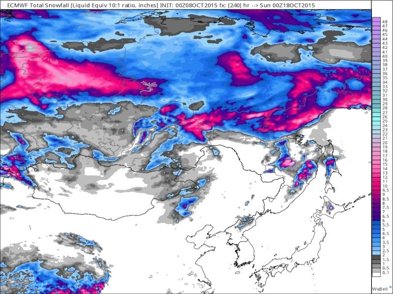
Here are the GFS and Euro total snowfall forecast over the next 10days. Take with a grain of salt but again snow growth in general is in the pattern over most of the Siberian, eastern Russia region. This also only takes us until about the 18th. If the pattern sets up the way I think after the 15th or so that snow growth over the following 10days should be even more extensive. Only one piece to the puzzle.

 " />
" />_________________
"In weather and in life, there's no winning and losing; there's only winning and learning."
WINTER 2012/2013 TOTALS 43.65"WINTER 2017/2018 TOTALS 62.85" WINTER 2022/2023 TOTALS 4.9"
WINTER 2013/2014 TOTALS 64.85"WINTER 2018/2019 TOTALS 14.25" WINTER 2023/2024 TOTALS 13.1"
WINTER 2014/2015 TOTALS 71.20"WINTER 2019/2020 TOTALS 6.35" WINTER 2024/2025 TOTALS 0.00
WINTER 2015/2016 TOTALS 35.00"WINTER 2020/2021 TOTALS 37.75"
WINTER 2016/2017 TOTALS 42.25"WINTER 2021/2022 TOTALS 31.65"

sroc4- Admin

- Posts : 8458
Reputation : 302
Join date : 2013-01-07
Location : Wading River, LI
 Re: Long Range Thread 8.0
Love it SROC I may have a full blow Puppy by then!!!
Here is a close picture of what the Euro showed for Jan through March - this would be great!!!

Here is a close picture of what the Euro showed for Jan through March - this would be great!!!

_________________
Mugs
AKA:King: Snow Weenie
Self Proclaimed
WINTER 2014-15 : 55.12" +.02 for 6 coatings (avg. 35")
WINTER 2015-16 Total - 29.8" (Avg 35")
WINTER 2016-17 : 39.5" so far

amugs- Advanced Forecaster - Mod

- Posts : 15155
Reputation : 213
Join date : 2013-01-07
Age : 54
Location : Hillsdale,NJ
 Re: Long Range Thread 8.0
Region 3.4 off the charts - good to see since this where we want he trop forcing to set up at near the dateline. https://twitter.com/ggweather/status/652113859705204736
Looks like another Jan to March winter incoming -as per the latest information - I know looonnngggg way to go - if we can get 1/2 December the its gravy if not another as we would say back loaded pattern - early but something I have been saying since June?
Looks like another Jan to March winter incoming -as per the latest information - I know looonnngggg way to go - if we can get 1/2 December the its gravy if not another as we would say back loaded pattern - early but something I have been saying since June?
_________________
Mugs
AKA:King: Snow Weenie
Self Proclaimed
WINTER 2014-15 : 55.12" +.02 for 6 coatings (avg. 35")
WINTER 2015-16 Total - 29.8" (Avg 35")
WINTER 2016-17 : 39.5" so far

amugs- Advanced Forecaster - Mod

- Posts : 15155
Reputation : 213
Join date : 2013-01-07
Age : 54
Location : Hillsdale,NJ
 Re: Long Range Thread 8.0
A good pattern setting up if it verifies:
Dec average to slightly above by this map, then we get the goods Jan, Feb and March - again by this set up depicted here.

Dec average to slightly above by this map, then we get the goods Jan, Feb and March - again by this set up depicted here.

_________________
Mugs
AKA:King: Snow Weenie
Self Proclaimed
WINTER 2014-15 : 55.12" +.02 for 6 coatings (avg. 35")
WINTER 2015-16 Total - 29.8" (Avg 35")
WINTER 2016-17 : 39.5" so far

amugs- Advanced Forecaster - Mod

- Posts : 15155
Reputation : 213
Join date : 2013-01-07
Age : 54
Location : Hillsdale,NJ
 Re: Long Range Thread 8.0
amugs wrote:A good pattern setting up if it verifies:
Dec average to slightly above by this map, then we get the goods Jan, Feb and March - again by this set up depicted here.
My totally analog seat of the pants thinking is for that back loaded winter.Just too warm of a september to think bitter cold in december.Thinking it will duplicate last winter, cranking up in late january.Again, I hope I get the chooch of prognostication award and it is cold and snowy form Thanksgiving through St Pats!!!

docstox12- Wx Statistician Guru

- Posts : 8615
Reputation : 222
Join date : 2013-01-07
Age : 74
Location : Monroe NY
 Re: Long Range Thread 8.0
HectorO wrote:The winter that never was : http://www.accuweather.com/en/weather-news/accuweathercom-winter-20112012/55890
http://www.accuweather.com/en/weather-blogs/anderson/the-20142015-accuweather-winter-forecast-for-canada/36489273 Last years "not supposed to be as cold as the year before....... right.
13/14 Pastelok was just babbling on. Above average temps, but we could see some below average temps. Above average snow, below average snow blah blah.
I remember viewing the 2011-12 Winter outlook article from Accuweather several times that winter and spring, and I have viewed it occasionally since then, although I'm really just there to see the hilarious comments at the bottom.
Math23x7- Wx Statistician Guru

- Posts : 2382
Reputation : 68
Join date : 2013-01-08
 Re: Long Range Thread 8.0
http://www.cbsnews.com/pictures/godzilla-el-nino-headed-for-california/
California may get needed rain but at a cost...from El Nino. I guess it makes sense California is the first stop.
California may get needed rain but at a cost...from El Nino. I guess it makes sense California is the first stop.

dkodgis- Senior Enthusiast

- Posts : 2692
Reputation : 98
Join date : 2013-12-29
 Re: Long Range Thread 8.0
I also thought the Inaccuweather article was poorly written and I threw it up here to see if folks would think along the same lines. It turns out many do and were much funnier about it than I could ever be. Yes, In accuweather is all about that hype and unfortunately I think Inaccuweather uses too much hype to drive sales. I'd like to see Henry M. and Joe Bastardi do some jello wrestling about the winter forecast!

dkodgis- Senior Enthusiast

- Posts : 2692
Reputation : 98
Join date : 2013-12-29
 Re: Long Range Thread 8.0
dkodgis wrote:http://www.cbsnews.com/pictures/godzilla-el-nino-headed-for-california/
California may get needed rain but at a cost...from El Nino. I guess it makes sense California is the first stop.
During El Nino years, central and southern California see above normal precipitation. Not atypical. Depending on how the jet stream is setup...some of those storms could make there way all the way to our area.
_________________
_______________________________________________________________________________________________________
CLICK HERE to view NJ Strong Snowstorm Classifications
 Re: Long Range Thread 8.0
Hmm eastern most ENSO regions cooling a bit over last 7 days


_________________
_______________________________________________________________________________________________________
CLICK HERE to view NJ Strong Snowstorm Classifications
 Re: Long Range Thread 8.0
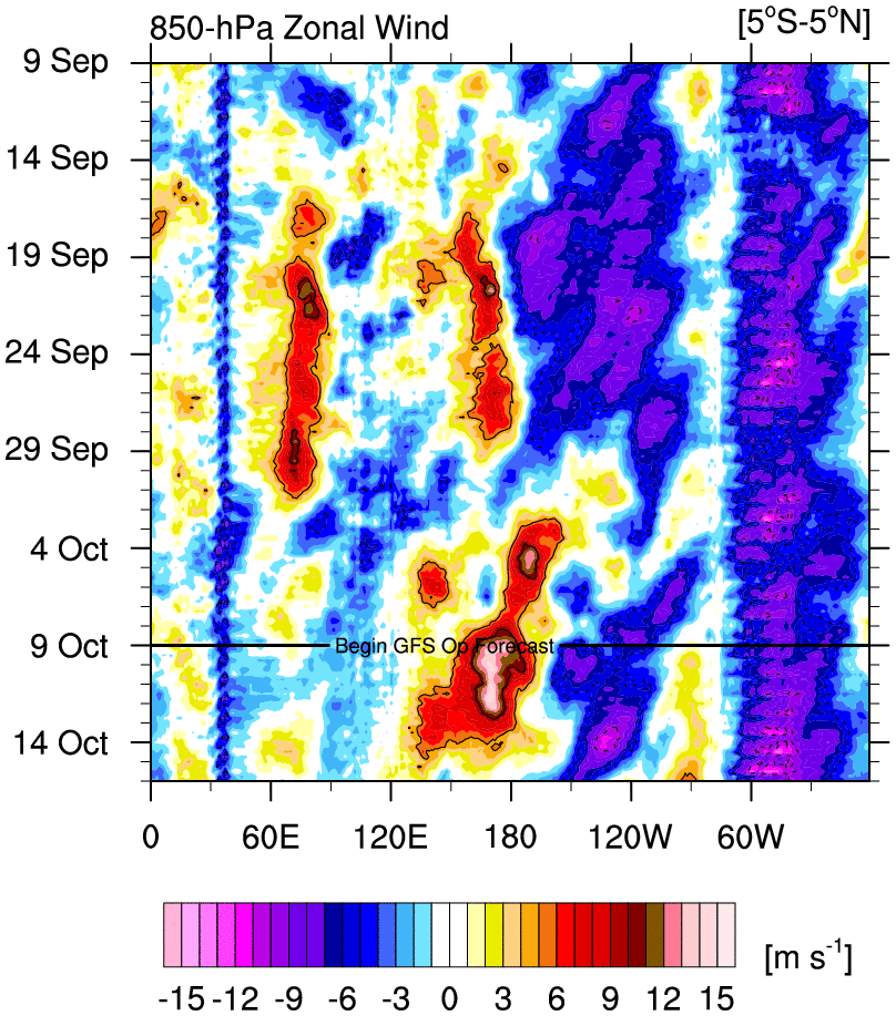
Frank this is inline with the WWB that happened over the SA coast I wrote about a few posts ago, those warm waters are migrating to the west and the dateline. Here is a post to back this up and a chart by Mike Ventrice. Very powerful WWB continuing, it has pushed all the way to 120W and further with strong westerly winds and still going:Frank_Wx wrote:Hmm eastern most ENSO regions cooling a bit over last 7 days
https://twitter.com/mjventrice/status/652485913860304896
I read that there is relationship between the October pattern and the winter pattern in a moderate to strong nino - 9 out of 11 have shown this. Anyone have such stats - I will try to dig this up but need 500mb anlags that I might be able to get my hands on.
_________________
Mugs
AKA:King: Snow Weenie
Self Proclaimed
WINTER 2014-15 : 55.12" +.02 for 6 coatings (avg. 35")
WINTER 2015-16 Total - 29.8" (Avg 35")
WINTER 2016-17 : 39.5" so far

amugs- Advanced Forecaster - Mod

- Posts : 15155
Reputation : 213
Join date : 2013-01-07
Age : 54
Location : Hillsdale,NJ
 Re: Long Range Thread 8.0
Interesting information on blocking in relation to the QBO:
For blocking, you want -QBO with low solar or +QBO with high solar - I don't know how true this is but interesting
For blocking, you want -QBO with low solar or +QBO with high solar - I don't know how true this is but interesting
Last edited by amugs on Fri Oct 09, 2015 5:17 pm; edited 1 time in total
_________________
Mugs
AKA:King: Snow Weenie
Self Proclaimed
WINTER 2014-15 : 55.12" +.02 for 6 coatings (avg. 35")
WINTER 2015-16 Total - 29.8" (Avg 35")
WINTER 2016-17 : 39.5" so far

amugs- Advanced Forecaster - Mod

- Posts : 15155
Reputation : 213
Join date : 2013-01-07
Age : 54
Location : Hillsdale,NJ
 Re: Long Range Thread 8.0
This winter set up??


_________________
Mugs
AKA:King: Snow Weenie
Self Proclaimed
WINTER 2014-15 : 55.12" +.02 for 6 coatings (avg. 35")
WINTER 2015-16 Total - 29.8" (Avg 35")
WINTER 2016-17 : 39.5" so far

amugs- Advanced Forecaster - Mod

- Posts : 15155
Reputation : 213
Join date : 2013-01-07
Age : 54
Location : Hillsdale,NJ
 Re: Long Range Thread 8.0
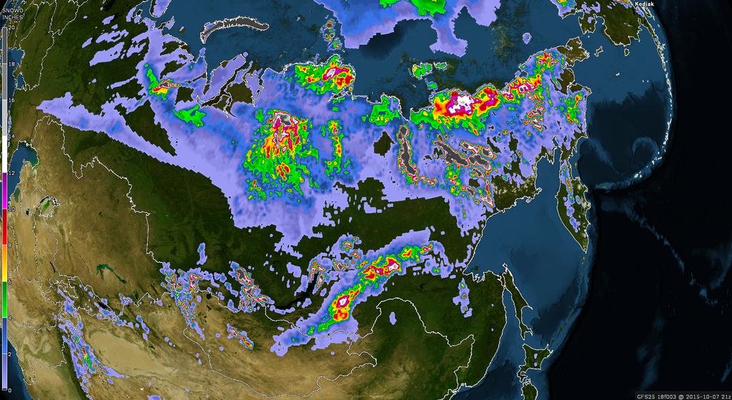
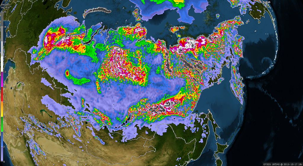
Look at how the ice is going to grow over the next 10 days in a really cool map:


_________________
Mugs
AKA:King: Snow Weenie
Self Proclaimed
WINTER 2014-15 : 55.12" +.02 for 6 coatings (avg. 35")
WINTER 2015-16 Total - 29.8" (Avg 35")
WINTER 2016-17 : 39.5" so far

amugs- Advanced Forecaster - Mod

- Posts : 15155
Reputation : 213
Join date : 2013-01-07
Age : 54
Location : Hillsdale,NJ
 Re: Long Range Thread 8.0
amugs wrote:Interesting information on blocking in relation to teh QBO:
For blocking, you want -QBO with low solar or +QBO with high solar - I don't know how true this is but ineteresting
So then I ask mugs where are we as we speak with qbo and solar activity. Where was the QBO last year during DJF?

skinsfan1177- Senior Enthusiast

- Posts : 4485
Reputation : 35
Join date : 2013-01-07
Age : 47
Location : Point Pleasant Boro
 Re: Long Range Thread 8.0
skinsfan1177 wrote:amugs wrote:Interesting information on blocking in relation to the QBO:
For blocking, you want -QBO with low solar or +QBO with high solar - I don't know how true this is but interesting
So then I ask mugs where are we as we speak with qbo and solar activity. Where was the QBO last year during DJF?
QBO was -20's but we had low solar activity in the summer and fall only to have two major solar flares in late Nov and one again in mid December if I recall correctly this delaying our winter. IF, and that is a big IF, those did not occur with a dip in the solar activity overall then winter would have been very close to December through March wall to wall - also Typhoon Nuri screwed things up as well in our pattern.
http://www.esrl.noaa.gov/psd/data/correlation/qbo.data
_________________
Mugs
AKA:King: Snow Weenie
Self Proclaimed
WINTER 2014-15 : 55.12" +.02 for 6 coatings (avg. 35")
WINTER 2015-16 Total - 29.8" (Avg 35")
WINTER 2016-17 : 39.5" so far

amugs- Advanced Forecaster - Mod

- Posts : 15155
Reputation : 213
Join date : 2013-01-07
Age : 54
Location : Hillsdale,NJ
 Re: Long Range Thread 8.0
amugs wrote:Interesting information on blocking in relation to the QBO:
For blocking, you want -QBO with low solar or +QBO with high solar - I don't know how true this is but interesting
Too bad we're going to see low solar with a +QBO to begin winter. But I honestly don't know how much impact this will have on the overall pattern.
_________________
_______________________________________________________________________________________________________
CLICK HERE to view NJ Strong Snowstorm Classifications
 Re: Long Range Thread 8.0
Frank_Wx wrote:amugs wrote:Interesting information on blocking in relation to the QBO:
For blocking, you want -QBO with low solar or +QBO with high solar - I don't know how true this is but interesting
Too bad we're going to see low solar with a +QBO to begin winter. But I honestly don't know how much impact this will have on the overall pattern.
Other factors come into play as well such as the Siberian snow cover and overall pattern up there and on the NPAC. WE can't get everything to fall in line now Frank, that would be to easy right?
_________________
Mugs
AKA:King: Snow Weenie
Self Proclaimed
WINTER 2014-15 : 55.12" +.02 for 6 coatings (avg. 35")
WINTER 2015-16 Total - 29.8" (Avg 35")
WINTER 2016-17 : 39.5" so far

amugs- Advanced Forecaster - Mod

- Posts : 15155
Reputation : 213
Join date : 2013-01-07
Age : 54
Location : Hillsdale,NJ
 Re: Long Range Thread 8.0
One of our own posted by Isotherm - backs up Frank's map above and 1.2 is cooling and will continue to do so as the DATELINE slightly warms and holds steady - what does this mean - EXCELLENT NEWS!!!!
Temperature depth anomaly progression indicates some fairly noteworthy subsurface cooling at approximately 80W-100W. There was a fairly expansive area of +6c anomalies near 50m depth; those anomalies have decreased to around +4c over the past week or so w/ some retrogression of the subsurface warm pool. This is probably indicative of the beginning stages of the gradual decline in region 1+2 anomalies which model data projects over the next month. My thinking is that region 1+2 values have likely reached their climax; there should be gradual cooling over the next month, as region 3 / 3.4 / 4 anomalies concurrently maintain their magnitude or warm slightly further.
Here's a map of the depth of the water temps:

It is beginning to show that 100W area is cooling in comparison (map is shunted and needs to go out to 40W to really show the 1.2 region but we see it on other maps so) to the 160W and 180W areas that have a deeper and warmer by about 2C water..
Temperature depth anomaly progression indicates some fairly noteworthy subsurface cooling at approximately 80W-100W. There was a fairly expansive area of +6c anomalies near 50m depth; those anomalies have decreased to around +4c over the past week or so w/ some retrogression of the subsurface warm pool. This is probably indicative of the beginning stages of the gradual decline in region 1+2 anomalies which model data projects over the next month. My thinking is that region 1+2 values have likely reached their climax; there should be gradual cooling over the next month, as region 3 / 3.4 / 4 anomalies concurrently maintain their magnitude or warm slightly further.
Here's a map of the depth of the water temps:

It is beginning to show that 100W area is cooling in comparison (map is shunted and needs to go out to 40W to really show the 1.2 region but we see it on other maps so) to the 160W and 180W areas that have a deeper and warmer by about 2C water..
_________________
Mugs
AKA:King: Snow Weenie
Self Proclaimed
WINTER 2014-15 : 55.12" +.02 for 6 coatings (avg. 35")
WINTER 2015-16 Total - 29.8" (Avg 35")
WINTER 2016-17 : 39.5" so far

amugs- Advanced Forecaster - Mod

- Posts : 15155
Reputation : 213
Join date : 2013-01-07
Age : 54
Location : Hillsdale,NJ
 Re: Long Range Thread 8.0
Here you go - come on euro do it!!


_________________
Mugs
AKA:King: Snow Weenie
Self Proclaimed
WINTER 2014-15 : 55.12" +.02 for 6 coatings (avg. 35")
WINTER 2015-16 Total - 29.8" (Avg 35")
WINTER 2016-17 : 39.5" so far

amugs- Advanced Forecaster - Mod

- Posts : 15155
Reputation : 213
Join date : 2013-01-07
Age : 54
Location : Hillsdale,NJ
 Re: Long Range Thread 8.0
frank scott and rb's forecast for mid late october look to be spot on.
nws disco... we are getting close
THURSDAY NIGHT-FRIDAY...AN AMPLIFYING UPPER LVL SHORT WV TROUGH
ALONG WITH A STRONG COLD FRONT WILL BRING THE COLDEST AIR OF THIS
SEASON BY NEXT WEEKEND. STAY TUNED.
cmc air temps next weekend gfs similar

nws disco... we are getting close
THURSDAY NIGHT-FRIDAY...AN AMPLIFYING UPPER LVL SHORT WV TROUGH
ALONG WITH A STRONG COLD FRONT WILL BRING THE COLDEST AIR OF THIS
SEASON BY NEXT WEEKEND. STAY TUNED.
cmc air temps next weekend gfs similar


algae888- Advanced Forecaster

- Posts : 5311
Reputation : 46
Join date : 2013-02-05
Age : 62
Location : mt. vernon, new york
 Re: Long Range Thread 8.0
Al if you want I wull post the euro ensembles. Not frost but freeze next weekend just outside the heat island/engine we call NYC.
_________________
Mugs
AKA:King: Snow Weenie
Self Proclaimed
WINTER 2014-15 : 55.12" +.02 for 6 coatings (avg. 35")
WINTER 2015-16 Total - 29.8" (Avg 35")
WINTER 2016-17 : 39.5" so far

amugs- Advanced Forecaster - Mod

- Posts : 15155
Reputation : 213
Join date : 2013-01-07
Age : 54
Location : Hillsdale,NJ
 Re: Long Range Thread 8.0

_________________
Mugs
AKA:King: Snow Weenie
Self Proclaimed
WINTER 2014-15 : 55.12" +.02 for 6 coatings (avg. 35")
WINTER 2015-16 Total - 29.8" (Avg 35")
WINTER 2016-17 : 39.5" so far

amugs- Advanced Forecaster - Mod

- Posts : 15155
Reputation : 213
Join date : 2013-01-07
Age : 54
Location : Hillsdale,NJ
 Re: Long Range Thread 8.0
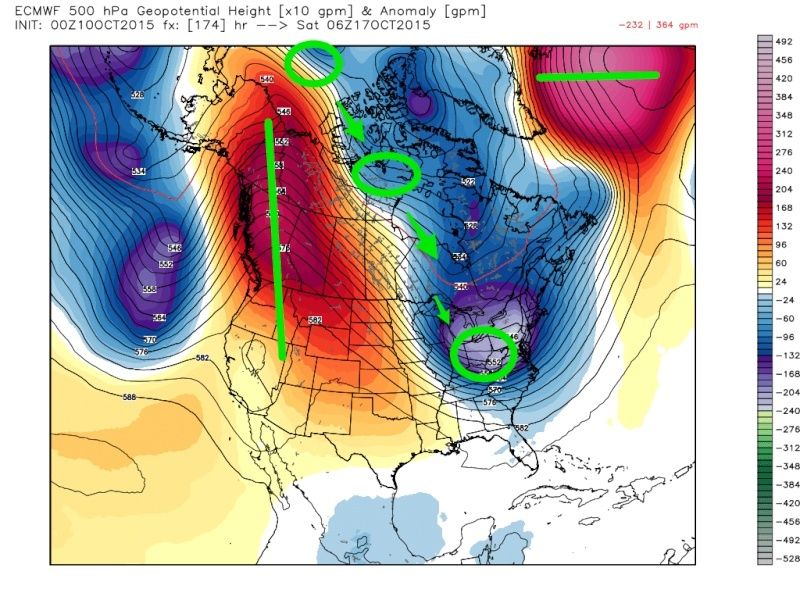
Madonne, very impressive amplification in our pattern late next week shown on guidance. The Pacific or Aleutian trough really helps to pump up the western ridge. A remnant ULL helps to separate the STJ with the PJ which further helps to bring positive heights as far north Alaska and the western province of Canada.
On the east, several shots of upper level energy track into our area to keep reinforcing the cold air. We have to watch for one of these vorts, because they could dig into the trough and develop a coastal storm. That could bring us our first snow flurries or showers of the season. Obviously those inland and into New England have a better shot at this than we do.
_________________
_______________________________________________________________________________________________________
CLICK HERE to view NJ Strong Snowstorm Classifications
 Re: Long Range Thread 8.0
The Euro is showing a storm around the 17th, and if anyone wants to see the first significant snow map (its all upstate and VT) let me know : ) Just for kicks though.

jmanley32- Senior Enthusiast

- Posts : 20646
Reputation : 108
Join date : 2013-12-12
Age : 43
Location : Yonkers, NY
Page 19 of 40 •  1 ... 11 ... 18, 19, 20 ... 29 ... 40
Page 19 of 40
Permissions in this forum:
You cannot reply to topics in this forum
 Home
Home