Long Range Thread 8.0
+30
Grselig
devsman
chief7
oldtimer
Noreaster
Quietace
mako460
jimv45
rb924119
sroc4
HectorO
snow247
essexcountypete
chinkaps
billg315
Snow88
dkodgis
docstox12
WOLVES1
nutleyblizzard
CPcantmeasuresnow
algae888
skinsfan1177
Dunnzoo
weatherwatchermom
Math23x7
jmanley32
amugs
Dtone
Frank_Wx
34 posters
Page 20 of 40
Page 20 of 40 •  1 ... 11 ... 19, 20, 21 ... 30 ... 40
 Re: Long Range Thread 8.0
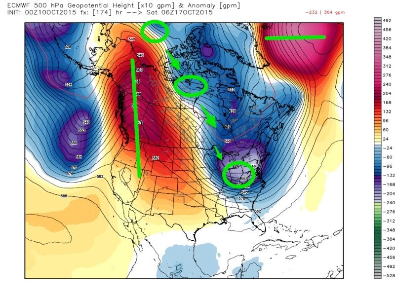
Madonne, very impressive amplification in our pattern late next week shown on guidance. The Pacific or Aleutian trough really helps to pump up the western ridge. A remnant ULL helps to separate the STJ with the PJ which further helps to bring positive heights as far north Alaska and the western province of Canada.
On the east, several shots of upper level energy track into our area to keep reinforcing the cold air. We have to watch for one of these vorts, because they could dig into the trough and develop a coastal storm. That could bring us our first snow flurries or showers of the season. Obviously those inland and into New England have a better shot at this than we do.
 Re: Long Range Thread 8.0
The Euro is showing a storm around the 17th, and if anyone wants to see the first significant snow map (its all upstate and VT) let me know : ) Just for kicks though.
jmanley32- Senior Enthusiast

- Posts : 20648
Join date : 2013-12-12
 Re: Long Range Thread 8.0
The only thing we are missing in that map Frank is a truly negative NAO. If my memory serves me correctly, I think the AO is negative, though during this same period?
rb924119- Meteorologist

- Posts : 7117
Reputation : 195
Join date : 2013-02-06
Age : 32
Location : Greentown, Pa
 Re: Long Range Thread 8.0
Snowstorm for NNE at 192 hours on the Euro?
http://mp1.met.psu.edu/~fxg1/ECMWF0.5_0z/ecmwfloop.html
http://mp1.met.psu.edu/~fxg1/ECMWF0.5_0z/ecmwfloop.html

Snow88- Senior Enthusiast

- Posts : 2193
Reputation : 4
Join date : 2013-01-09
Age : 36
Location : Brooklyn, NY
 Re: Long Range Thread 8.0
rb924119 wrote:The only thing we are missing in that map Frank is a truly negative NAO. If my memory serves me correctly, I think the AO is negative, though during this same period?
Yes, but it's closer to neutral than it is -1. The cold air is not overly impressive despite the low heights. PV is still in the Arctic.
_________________
_______________________________________________________________________________________________________
CLICK HERE to view NJ Strong Snowstorm Classifications
 Re: Long Range Thread 8.0
Snow88 wrote:Snowstorm for NNE at 192 hours on the Euro?
http://mp1.met.psu.edu/~fxg1/ECMWF0.5_0z/ecmwfloop.html
This is what Jman is talking about. It's very possible for them.
_________________
_______________________________________________________________________________________________________
CLICK HERE to view NJ Strong Snowstorm Classifications
 Re: Long Range Thread 8.0
Frank let's hope this is a harbinger of things to come. While in the fall you will see changing weather patterns partly due to the shortening of wavelengths, you will often see a dominate weather pattern regime start to take hold. Presently I like how the Pacific anomalies are setting up. The Atlantic is the wildcard player yet there are signs it will cooperate as well. Things should be much clearer by early November to see what winter has in store for us, but I'm optimistic.Frank_Wx wrote:
Madonne, very impressive amplification in our pattern late next week shown on guidance. The Pacific or Aleutian trough really helps to pump up the western ridge. A remnant ULL helps to separate the STJ with the PJ which further helps to bring positive heights as far north Alaska and the western province of Canada.
On the east, several shots of upper level energy track into our area to keep reinforcing the cold air. We have to watch for one of these vorts, because they could dig into the trough and develop a coastal storm. That could bring us our first snow flurries or showers of the season. Obviously those inland and into New England have a better shot at this than we do.

nutleyblizzard- Senior Enthusiast

- Posts : 1964
Reputation : 42
Join date : 2014-01-30
Age : 58
Location : Nutley, new jersey
 Re: Long Range Thread 8.0
No, but it is only mid-October, and there isn't much in the way of snowpack in eastern Canada so it can moderate before getting here. That said, I think the snowpack in that region is going to blossom over the next one to two weeks, which will only help us in the long run. I'm totally ok with moderation now, as long as it works toward setting us up for the goods this winter.
rb924119- Meteorologist

- Posts : 7117
Reputation : 195
Join date : 2013-02-06
Age : 32
Location : Greentown, Pa

Snow88- Senior Enthusiast

- Posts : 2193
Reputation : 4
Join date : 2013-01-09
Age : 36
Location : Brooklyn, NY
 Re: Long Range Thread 8.0
jmanley32 wrote:The Euro is showing a storm around the 17th, and if anyone wants to see the first significant snow map (its all upstate and VT) let me know : ) Just for kicks though.
Put it in Banter JMAN
_________________
Mugs
AKA:King: Snow Weenie
Self Proclaimed
WINTER 2014-15 : 55.12" +.02 for 6 coatings (avg. 35")
WINTER 2015-16 Total - 29.8" (Avg 35")
WINTER 2016-17 : 39.5" so far

amugs- Advanced Forecaster - Mod

- Posts : 15157
Reputation : 213
Join date : 2013-01-07
Age : 54
Location : Hillsdale,NJ
 Re: Long Range Thread 8.0
Check out 1997 in comparison to today's El Nino - major differences - 1.2 and 3 are ridiculously warmer and look at the beautiful pool of warm/hot water in the GOA!!
Today - come to poppa

1997 - wonder why we torched that winter???

Today - come to poppa

1997 - wonder why we torched that winter???

Last edited by amugs on Sun Oct 11, 2015 12:43 pm; edited 1 time in total
_________________
Mugs
AKA:King: Snow Weenie
Self Proclaimed
WINTER 2014-15 : 55.12" +.02 for 6 coatings (avg. 35")
WINTER 2015-16 Total - 29.8" (Avg 35")
WINTER 2016-17 : 39.5" so far

amugs- Advanced Forecaster - Mod

- Posts : 15157
Reputation : 213
Join date : 2013-01-07
Age : 54
Location : Hillsdale,NJ
 Re: Long Range Thread 8.0
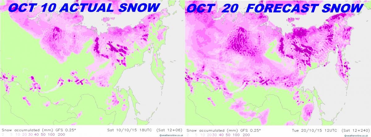
Siberia SNOW COVER - BOOM!!!!!!!!!!!!!!
CANADA

Monday Oct 5th


CANADA

Monday Oct 5th

_________________
Mugs
AKA:King: Snow Weenie
Self Proclaimed
WINTER 2014-15 : 55.12" +.02 for 6 coatings (avg. 35")
WINTER 2015-16 Total - 29.8" (Avg 35")
WINTER 2016-17 : 39.5" so far

amugs- Advanced Forecaster - Mod

- Posts : 15157
Reputation : 213
Join date : 2013-01-07
Age : 54
Location : Hillsdale,NJ
 Re: Long Range Thread 8.0
amugs wrote:Check out 1997 in comparison to today's El Nino - major differences - 1.2 and 3 are ridiculously warmer and look at the beautiful pool of warm/hot water in the GOA!!
Today - come to poppa
Look like they took the idea of a strong el nino and "spread the wealth" instead of all the heat built up in one area.
1997 - wonder why we torched that winter???
NjWeatherGuy- Advanced Forecaster

- Posts : 4100
Reputation : 28
Join date : 2013-01-06
Location : Belle Mead, NJ
 Re: Long Range Thread 8.0
Why did it post like that, my commet in between two pics and the 1997.

NjWeatherGuy- Advanced Forecaster

- Posts : 4100
Reputation : 28
Join date : 2013-01-06
Location : Belle Mead, NJ
 Re: Long Range Thread 8.0
Also there are major deep ULL over that area for the next 10 days so we should see the snow growth increase by A LOT!!!!!
_________________
Mugs
AKA:King: Snow Weenie
Self Proclaimed
WINTER 2014-15 : 55.12" +.02 for 6 coatings (avg. 35")
WINTER 2015-16 Total - 29.8" (Avg 35")
WINTER 2016-17 : 39.5" so far

amugs- Advanced Forecaster - Mod

- Posts : 15157
Reputation : 213
Join date : 2013-01-07
Age : 54
Location : Hillsdale,NJ
 Re: Long Range Thread 8.0
NjWeatherGuy wrote:Why did it post like that, my commet in between two pics and the 1997.
HMMM??
Basin wide event my man and no worries thanks for commenting.
_________________
Mugs
AKA:King: Snow Weenie
Self Proclaimed
WINTER 2014-15 : 55.12" +.02 for 6 coatings (avg. 35")
WINTER 2015-16 Total - 29.8" (Avg 35")
WINTER 2016-17 : 39.5" so far

amugs- Advanced Forecaster - Mod

- Posts : 15157
Reputation : 213
Join date : 2013-01-07
Age : 54
Location : Hillsdale,NJ
 Re: Long Range Thread 8.0
Rutgers says HI - catching up
2015

2014

2015

2014

_________________
Mugs
AKA:King: Snow Weenie
Self Proclaimed
WINTER 2014-15 : 55.12" +.02 for 6 coatings (avg. 35")
WINTER 2015-16 Total - 29.8" (Avg 35")
WINTER 2016-17 : 39.5" so far

amugs- Advanced Forecaster - Mod

- Posts : 15157
Reputation : 213
Join date : 2013-01-07
Age : 54
Location : Hillsdale,NJ
 Re: Long Range Thread 8.0
NjWeatherGuy wrote:Why did it post like that, my commet in between two pics and the 1997.
When you quote someone, make sure you type your reply below their entire post.
_________________
_______________________________________________________________________________________________________
CLICK HERE to view NJ Strong Snowstorm Classifications
 Re: Long Range Thread 8.0
Mugs even though we are behind last year in coverage this year may have a better effect on the AO as most of this years snow growth will occur in mid to late october. Last years snow growth was sept and early october then she leveled off. Most mets believe its the october smow growth that has the most impact on the AO. Anyway thats what i have been hearing from several different mets.amugs wrote:Rutgers says HI - catching up
2015
2014

algae888- Advanced Forecaster

- Posts : 5311
Reputation : 46
Join date : 2013-02-05
Age : 62
Location : mt. vernon, new york
 Re: Long Range Thread 8.0
algae888 wrote:Mugs even though we are behind last year in coverage this year may have a better effect on the AO as most of this years snow growth will occur in mid to late october. Last years snow growth was sept and early october then she leveled off. Most mets believe its the october smow growth that has the most impact on the AO. Anyway thats what i have been hearing from several different mets.amugs wrote:Rutgers says HI - catching up
2015
2014
Al, you're correct.
_________________
_______________________________________________________________________________________________________
CLICK HERE to view NJ Strong Snowstorm Classifications
 Re: Long Range Thread 8.0
Yes we has record snow growth in that time frame and then lost 700k of snow and ice heading in late Nov. So with that being said most Mets are all on board and you will see Siberia and the like go KABOOM in the next couple of weeks in this dept as I showed with the map I posted above. Updates will be forthcoming.
_________________
Mugs
AKA:King: Snow Weenie
Self Proclaimed
WINTER 2014-15 : 55.12" +.02 for 6 coatings (avg. 35")
WINTER 2015-16 Total - 29.8" (Avg 35")
WINTER 2016-17 : 39.5" so far

amugs- Advanced Forecaster - Mod

- Posts : 15157
Reputation : 213
Join date : 2013-01-07
Age : 54
Location : Hillsdale,NJ
 Re: Long Range Thread 8.0
Here is a great link to see the snow growth in the arctic region. Change the dates and hit play and watch Rocky my chia pet grow!!
http://www.ncdc.noaa.gov/snow-and-ice/snow-cover/nh/20151002-20151010
http://www.ncdc.noaa.gov/snow-and-ice/snow-cover/nh/20151002-20151010
_________________
Mugs
AKA:King: Snow Weenie
Self Proclaimed
WINTER 2014-15 : 55.12" +.02 for 6 coatings (avg. 35")
WINTER 2015-16 Total - 29.8" (Avg 35")
WINTER 2016-17 : 39.5" so far

amugs- Advanced Forecaster - Mod

- Posts : 15157
Reputation : 213
Join date : 2013-01-07
Age : 54
Location : Hillsdale,NJ
 Re: Long Range Thread 8.0
Despite the positive heights in the west, namely Alaska into western province of Canada, the NAO shift from east-based to positive by the 3rd week of October. This could make the cold spell we see beginning Tuesday night be short-lived (until next Monday)


_________________
_______________________________________________________________________________________________________
CLICK HERE to view NJ Strong Snowstorm Classifications
 Re: Long Range Thread 8.0
Cold temps for the weekend


_________________
Mugs
AKA:King: Snow Weenie
Self Proclaimed
WINTER 2014-15 : 55.12" +.02 for 6 coatings (avg. 35")
WINTER 2015-16 Total - 29.8" (Avg 35")
WINTER 2016-17 : 39.5" so far

amugs- Advanced Forecaster - Mod

- Posts : 15157
Reputation : 213
Join date : 2013-01-07
Age : 54
Location : Hillsdale,NJ
 Re: Long Range Thread 8.0
This from Isotherm on El Nino
Tropical convective forcing has generally congregated around 160-180W over the past week [continued conducive forcing overall].
Date Line baby - woop woop. This is where the forcing looks to be/will set up - great news.

Evolution the past week

Tropical convective forcing has generally congregated around 160-180W over the past week [continued conducive forcing overall].
Date Line baby - woop woop. This is where the forcing looks to be/will set up - great news.

Evolution the past week

_________________
Mugs
AKA:King: Snow Weenie
Self Proclaimed
WINTER 2014-15 : 55.12" +.02 for 6 coatings (avg. 35")
WINTER 2015-16 Total - 29.8" (Avg 35")
WINTER 2016-17 : 39.5" so far

amugs- Advanced Forecaster - Mod

- Posts : 15157
Reputation : 213
Join date : 2013-01-07
Age : 54
Location : Hillsdale,NJ
 Re: Long Range Thread 8.0
Although I'm willing to wait and see where we stand in a month as far as anomaly placements are concerned, I'm beginning to grow increasingly confident that we will see an above normal snowfall season if not historic. I wonder what Frank's thoughts are. Guess we will wait till November 1st.amugs wrote:This from Isotherm on El Nino
Tropical convective forcing has generally congregated around 160-180W over the past week [continued conducive forcing overall].
Date Line baby - woop woop. This is where the forcing looks to be/will set up - great news.
Evolution the past week

nutleyblizzard- Senior Enthusiast

- Posts : 1964
Reputation : 42
Join date : 2014-01-30
Age : 58
Location : Nutley, new jersey
 Re: Long Range Thread 8.0
Hearing models GFS and Euro both have backed off the blocking.

skinsfan1177- Senior Enthusiast

- Posts : 4485
Reputation : 35
Join date : 2013-01-07
Age : 47
Location : Point Pleasant Boro
Page 20 of 40 •  1 ... 11 ... 19, 20, 21 ... 30 ... 40
Page 20 of 40
Permissions in this forum:
You cannot reply to topics in this forum
 Home
Home
