Long Range Thread 8.0
+30
Grselig
devsman
chief7
oldtimer
Noreaster
Quietace
mako460
jimv45
rb924119
sroc4
HectorO
snow247
essexcountypete
chinkaps
billg315
Snow88
dkodgis
docstox12
WOLVES1
nutleyblizzard
CPcantmeasuresnow
algae888
skinsfan1177
Dunnzoo
weatherwatchermom
Math23x7
jmanley32
amugs
Dtone
Frank_Wx
34 posters
Page 23 of 40
Page 23 of 40 •  1 ... 13 ... 22, 23, 24 ... 31 ... 40
 Re: Long Range Thread 8.0
Frank_Wx wrote:I don't want to give anything away from my winter outlook, but I will say this will be one of those seasons when all it will take is 1 collasal Snowstorm to achieve our seasonal snowfall.
Ohhh sneaky tidbits, man if its one of those years where its boring until boom one day and thats it that one day will be gr8 but man waiting for when that happens will be tough. If we used the totals from last year in one storm that would be a frankroidzillajmanazoola. LOL
Give me 4 feet plus of snow and 75mph winds and i'll be one drooling camper. lol
jmanley32- Senior Enthusiast

- Posts : 20645
Join date : 2013-12-12
 Re: Long Range Thread 8.0
Dunnzoo wrote:syosnow94 wrote:Just heard on WCBS 880 a.m. at 3:00 p.m. that this winter will be much milder and wetter for the tri-state area with way less snow than last year. It was one of their headline stories at 3.


Looks like they are taking NOAA's forecast
Is there a dislike button?
jmanley32- Senior Enthusiast

- Posts : 20645
Join date : 2013-12-12
 Re: Long Range Thread 8.0
Frank_Wx wrote:I don't want to give anything away from my winter outlook, but I will say this will be one of those seasons when all it will take is 1 collasal Snowstorm to achieve our seasonal snowfall.
Or two to double it.
_________________
"In weather and in life, there's no winning and losing; there's only winning and learning."
WINTER 2012/2013 TOTALS 43.65"WINTER 2017/2018 TOTALS 62.85" WINTER 2022/2023 TOTALS 4.9"
WINTER 2013/2014 TOTALS 64.85"WINTER 2018/2019 TOTALS 14.25" WINTER 2023/2024 TOTALS 13.1"
WINTER 2014/2015 TOTALS 71.20"WINTER 2019/2020 TOTALS 6.35" WINTER 2024/2025 TOTALS 0.00
WINTER 2015/2016 TOTALS 35.00"WINTER 2020/2021 TOTALS 37.75"
WINTER 2016/2017 TOTALS 42.25"WINTER 2021/2022 TOTALS 31.65"

sroc4- Admin

- Posts : 8458
Reputation : 302
Join date : 2013-01-07
Location : Wading River, LI
 Re: Long Range Thread 8.0
http://www.accuweather.com/en/weather-news/how-will-el-nino-affect-us-weather-winter-forecast/52974535
Inaccuweather's take at this juncture.
Wild card is the timing of the cold air with the storminess.This bolster's Frank's preview of a monster snowstorm adding to the totals.Seems like this warm to cold to warm pattern will be in effect this week.Could this be a preview of the temperature swings this winter season.Anyhoo, in my limited ability to interpret this data, I would assume there will be more chances of a classic Miller A coming up from the Gulf.

docstox12- Wx Statistician Guru

- Posts : 8611
Reputation : 222
Join date : 2013-01-07
Age : 74
Location : Monroe NY
 Re: Long Range Thread 8.0
sroc4 wrote:Frank_Wx wrote:I don't want to give anything away from my winter outlook, but I will say this will be one of those seasons when all it will take is 1 collasal Snowstorm to achieve our seasonal snowfall.
Or two to double it.
I have to meet you man. Ever the optimist!!!
Guest- Guest
 Re: Long Range Thread 8.0
This a great read about this upcoming winter.
http://easternmassweather.blogspot.com/
http://easternmassweather.blogspot.com/
_________________
Mugs
AKA:King: Snow Weenie
Self Proclaimed
WINTER 2014-15 : 55.12" +.02 for 6 coatings (avg. 35")
WINTER 2015-16 Total - 29.8" (Avg 35")
WINTER 2016-17 : 39.5" so far

amugs- Advanced Forecaster - Mod

- Posts : 15148
Reputation : 213
Join date : 2013-01-07
Age : 54
Location : Hillsdale,NJ
 Re: Long Range Thread 8.0
Dunnzoo wrote:syosnow94 wrote:Just heard on WCBS 880 a.m. at 3:00 p.m. that this winter will be much milder and wetter for the tri-state area with way less snow than last year. It was one of their headline stories at 3.


Looks like they are taking NOAA's forecast
This is a basic strong nino map, I am sorry but I am not buying this as our overall pattern this winter - may is start ln January and be back loaded and delay spring more likely. Interesting listening to Nick Gregory last night and he said I can see this map for Dec and part of Jan but I think Feb and into March we have a colder period and the split flow jet -Northern/polar jet and southern branch - the sub tropical jet will phase and produce nor'easters and coastal lows, that he said is most likely this winter with this pattern. Too early to call this now - we still have a few weeks to see what is what.
_________________
Mugs
AKA:King: Snow Weenie
Self Proclaimed
WINTER 2014-15 : 55.12" +.02 for 6 coatings (avg. 35")
WINTER 2015-16 Total - 29.8" (Avg 35")
WINTER 2016-17 : 39.5" so far

amugs- Advanced Forecaster - Mod

- Posts : 15148
Reputation : 213
Join date : 2013-01-07
Age : 54
Location : Hillsdale,NJ
 Re: Long Range Thread 8.0
JMAN - here you go - the tropics showing some activity late next week. Could get interesting


Last edited by amugs on Fri Oct 16, 2015 5:44 pm; edited 1 time in total
_________________
Mugs
AKA:King: Snow Weenie
Self Proclaimed
WINTER 2014-15 : 55.12" +.02 for 6 coatings (avg. 35")
WINTER 2015-16 Total - 29.8" (Avg 35")
WINTER 2016-17 : 39.5" so far

amugs- Advanced Forecaster - Mod

- Posts : 15148
Reputation : 213
Join date : 2013-01-07
Age : 54
Location : Hillsdale,NJ
 Re: Long Range Thread 8.0
Hey,
I gotta say that I am a little worried about NOAA putting out this winter outlook of above average temps. and wet weather. I know it's way early and most of the long range telecommunications at this point seem favorable for a good winter but........you have to give some credence to NOAA.
Personally I feel we probably won't be as cold as last season (no ice rink for 6 straight weeks in the backyard on LI) but probably more big coastal storms (miller a's for Doc and CP) causing mixing issues down here on the coast. We've had a great run here S and E. It's improbable to think it continues. (Or is it Sroc?)
Guest- Guest
 Re: Long Range Thread 8.0
syosnow94 wrote:Hey,
I gotta say that I am a little worried about NOAA putting out this winter outlook of above average temps. and wet weather. I know it's way early and most of the long range telecommunications at this point seem favorable for a good winter but........you have to give some credence to NOAA.
Personally I feel we probably won't be as cold as last season (no ice rink for 6 straight weeks in the backyard on LI) but probably more big coastal storms (miller a's for Doc and CP) causing mixing issues down here on the coast. We've had a great run here S and E. It's improbable to think it continues. (Or is it Sroc?)
I'm not sure how much credence they deserve. Here was their winter outlook last year

Here it was 2 years ago

Let's just say very poor track record.
_________________
_______________________________________________________________________________________________________
CLICK HERE to view NJ Strong Snowstorm Classifications
 Re: Long Range Thread 8.0
Frank_Wx wrote:syosnow94 wrote:Hey,
I gotta say that I am a little worried about NOAA putting out this winter outlook of above average temps. and wet weather. I know it's way early and most of the long range telecommunications at this point seem favorable for a good winter but........you have to give some credence to NOAA.
Personally I feel we probably won't be as cold as last season (no ice rink for 6 straight weeks in the backyard on LI) but probably more big coastal storms (miller a's for Doc and CP) causing mixing issues down here on the coast. We've had a great run here S and E. It's improbable to think it continues. (Or is it Sroc?)
I'm not sure how much credence they deserve. Here was their winter outlook last year
Here it was 2 years ago
Let's just say very poor track record.
In the bayou and still post from NOLA!! Love it - and I was just looking for their predictions last year - so we take with a grain of salt.
_________________
Mugs
AKA:King: Snow Weenie
Self Proclaimed
WINTER 2014-15 : 55.12" +.02 for 6 coatings (avg. 35")
WINTER 2015-16 Total - 29.8" (Avg 35")
WINTER 2016-17 : 39.5" so far

amugs- Advanced Forecaster - Mod

- Posts : 15148
Reputation : 213
Join date : 2013-01-07
Age : 54
Location : Hillsdale,NJ
 Re: Long Range Thread 8.0
Me too, mugs, for some reason your posts are not showing up but todays Euro shows double trouble, I posted in banter.

jmanley32- Senior Enthusiast

- Posts : 20645
Reputation : 108
Join date : 2013-12-12
Age : 43
Location : Yonkers, NY
 Re: Long Range Thread 8.0
The Euro does not depict much of a warm up. We look to stay mainly in the 60s to low 70s. Pretty much seasonable. There's a trough in southeast Canada preventing heights from rising excessively over the northeast.
And yes, the EURO also shows a couple of tropical systems we will have to watch closely. This would be around Halloween.
And yes, the EURO also shows a couple of tropical systems we will have to watch closely. This would be around Halloween.
_________________
_______________________________________________________________________________________________________
CLICK HERE to view NJ Strong Snowstorm Classifications
 Re: Long Range Thread 8.0
MJO is barking in phase two around that time.
_________________
"In weather and in life, there's no winning and losing; there's only winning and learning."
WINTER 2012/2013 TOTALS 43.65"WINTER 2017/2018 TOTALS 62.85" WINTER 2022/2023 TOTALS 4.9"
WINTER 2013/2014 TOTALS 64.85"WINTER 2018/2019 TOTALS 14.25" WINTER 2023/2024 TOTALS 13.1"
WINTER 2014/2015 TOTALS 71.20"WINTER 2019/2020 TOTALS 6.35" WINTER 2024/2025 TOTALS 0.00
WINTER 2015/2016 TOTALS 35.00"WINTER 2020/2021 TOTALS 37.75"
WINTER 2016/2017 TOTALS 42.25"WINTER 2021/2022 TOTALS 31.65"

sroc4- Admin

- Posts : 8458
Reputation : 302
Join date : 2013-01-07
Location : Wading River, LI
 Re: Long Range Thread 8.0
So the Euro GFS CMC and I believe NAVGEM have been damn consistent on two maybe even 3 tropical developments and in pretty much the same areas for over a week now. That to me is interesting, and regardless where they go due to the time of year and our past history (ie 2012. and others I am probably not thinking of) October can be ugly for us. What are your guys thinking? sroc the MJO tanking what does that mean for us if those systems do actually come to fruition which they look like they will unless the models are all using.


jmanley32- Senior Enthusiast

- Posts : 20645
Reputation : 108
Join date : 2013-12-12
Age : 43
Location : Yonkers, NY
 Re: Long Range Thread 8.0
Frank from that map, if I was you (I know your not into the whole tropical thing) I would book another two weeks lol.

jmanley32- Senior Enthusiast

- Posts : 20645
Reputation : 108
Join date : 2013-12-12
Age : 43
Location : Yonkers, NY
 Re: Long Range Thread 8.0
I'm not buying into any tropical development in the Atlantic just yet. Conditions don't look ripe in the Atlantic at this time. I do see how a tropical storm or weak hurricane could develop in the Gulf of Mexico and threaten the Gulf Coast states. There's a piece of energy near the Yucatan that's forecasted to go into the warm waters of the Gulf. We'll see how this trends with the models.
_________________
_______________________________________________________________________________________________________
CLICK HERE to view NJ Strong Snowstorm Classifications
 Re: Long Range Thread 8.0
Frank_Wx wrote:I'm not buying into any tropical development in the Atlantic just yet. Conditions don't look ripe in the Atlantic at this time. I do see how a tropical storm or weak hurricane could develop in the Gulf of Mexico and threaten the Gulf Coast states. There's a piece of energy near the Yucatan that's forecasted to go into the warm waters of the Gulf. We'll see how this trends with the models.
Arent you on vacation?
_________________
"In weather and in life, there's no winning and losing; there's only winning and learning."
WINTER 2012/2013 TOTALS 43.65"WINTER 2017/2018 TOTALS 62.85" WINTER 2022/2023 TOTALS 4.9"
WINTER 2013/2014 TOTALS 64.85"WINTER 2018/2019 TOTALS 14.25" WINTER 2023/2024 TOTALS 13.1"
WINTER 2014/2015 TOTALS 71.20"WINTER 2019/2020 TOTALS 6.35" WINTER 2024/2025 TOTALS 0.00
WINTER 2015/2016 TOTALS 35.00"WINTER 2020/2021 TOTALS 37.75"
WINTER 2016/2017 TOTALS 42.25"WINTER 2021/2022 TOTALS 31.65"

sroc4- Admin

- Posts : 8458
Reputation : 302
Join date : 2013-01-07
Location : Wading River, LI
 Re: Long Range Thread 8.0
sroc4 wrote:Frank_Wx wrote:I'm not buying into any tropical development in the Atlantic just yet. Conditions don't look ripe in the Atlantic at this time. I do see how a tropical storm or weak hurricane could develop in the Gulf of Mexico and threaten the Gulf Coast states. There's a piece of energy near the Yucatan that's forecasted to go into the warm waters of the Gulf. We'll see how this trends with the models.
Arent you on vacation?
Yes, but usually the first thing I do when I wake up is check prior day model runs and provide updates. Speaking of, today's 12z GFS shows nothing of significance in the long range. Hints at a stormy pattern possibly by end of month.
_________________
_______________________________________________________________________________________________________
CLICK HERE to view NJ Strong Snowstorm Classifications
 Re: Long Range Thread 8.0
here is steve d winter forecast map...


algae888- Advanced Forecaster

- Posts : 5311
Reputation : 46
Join date : 2013-02-05
Age : 62
Location : mt. vernon, new york
 Re: Long Range Thread 8.0
here is his summary..
Okay so you can see what I’ve been tracking for months and breaking down all the factors. So let me put this all together for you.
We start with El Nino which is strong right now but expected to weaken. A typical climatology strong El Nino would suggest the Polar jet stream gets blocked to the north and a mild winter ensues, however this is no typical strong El Nino as we have seen above. The location of convection all Fall is a major warning sign against a warm winter from coast to coast. There is also the matter of a positive PDO which points to below normal heights below the Aleutian Islands and above normal heights over western North America. The positive PDO also points to below normal heights over the Gulf Coast and Southeast. So these factors suggest a rather stormy weather pattern along the Gulf Coast, Tennessee River Valley, Southeast, and Mid Atlantic.
Next, we have the Atlantic with a very cold area of water in the northwestern Atlantic and well above normal water temperatures along the East coast. These factors have supported in the past and likely will this Winter a negative NAO pattern in the northern Atlantic along with a high threat potential for low pressure development from the Southeast coast to the Mid Atlantic coast. This would suggest a high threat for Nor’Easters via Miller A and B type varieties.
Finally, the stratospheric influences from solar activity, Siberia snow growth, and QBO influences all point to a high threat for strong high latitude blocking which will show up as a negative Eastern Pacific Oscillation, negative Arctic Oscillation, and negative North Atlantic Oscillation.

algae888- Advanced Forecaster

- Posts : 5311
Reputation : 46
Join date : 2013-02-05
Age : 62
Location : mt. vernon, new york
 Re: Long Range Thread 8.0
Al great write up. The factors for this winter are coming together. You will see people say El Nino is going to override everything and say it us east based there is and will be s light spike in the east vase waters of region 1.2 due to a big Web and Kelvin wave but it will only get to around 120w or so. Once that abades then the show begins as it cools and the trop forcing sets up a camp,where it is already, fir the winter months. A few more days fir my Chia pet Rocky to grow and I will do a comparis on this fir our memebers. Great job and thanks for sharing.
_________________
Mugs
AKA:King: Snow Weenie
Self Proclaimed
WINTER 2014-15 : 55.12" +.02 for 6 coatings (avg. 35")
WINTER 2015-16 Total - 29.8" (Avg 35")
WINTER 2016-17 : 39.5" so far

amugs- Advanced Forecaster - Mod

- Posts : 15148
Reputation : 213
Join date : 2013-01-07
Age : 54
Location : Hillsdale,NJ
 Re: Long Range Thread 8.0
https://twitter.com/nj_strong_wx/status/655778718724456448
_________________
_______________________________________________________________________________________________________
CLICK HERE to view NJ Strong Snowstorm Classifications
 Re: Long Range Thread 8.0


End of October beginning of November = interesting
_________________
Mugs
AKA:King: Snow Weenie
Self Proclaimed
WINTER 2014-15 : 55.12" +.02 for 6 coatings (avg. 35")
WINTER 2015-16 Total - 29.8" (Avg 35")
WINTER 2016-17 : 39.5" so far

amugs- Advanced Forecaster - Mod

- Posts : 15148
Reputation : 213
Join date : 2013-01-07
Age : 54
Location : Hillsdale,NJ
 Re: Long Range Thread 8.0
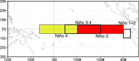
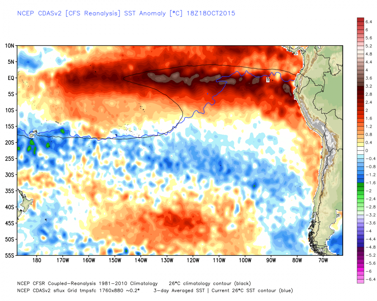
El Nino - Modoki style here peeps and this type of set up favors the mid Atlantic region

Need to nudge that Aluetian LP a bit west and BOOOOOMMMMM!!
1.2 down - YESSS!!!
Nino 1+2 and 3 down...3.4 steady....4 up.
1.2 3 3.4 4 (Dateline!!!)
07OCT2015 2.7 2.8 2.4 1.0
14OCT2015 2.5 2.6 2.4 1.1
Lets look


So what does this mean?? It means the trop forcing will be setting up at the DL(dateline) which is excellent news at this stage - it may take until January to get all the players playing nice/coming together (epo, pna, ao and nao) but this means we do not have a 97-98 blowtorch winter. So IMHO forget the warm solution that some are suggesting!

Need to nudge that Aluetian LP a bit west and BOOOOOMMMMM!!
1.2 down - YESSS!!!
Nino 1+2 and 3 down...3.4 steady....4 up.
1.2 3 3.4 4 (Dateline!!!)
07OCT2015 2.7 2.8 2.4 1.0
14OCT2015 2.5 2.6 2.4 1.1
Lets look


So what does this mean?? It means the trop forcing will be setting up at the DL(dateline) which is excellent news at this stage - it may take until January to get all the players playing nice/coming together (epo, pna, ao and nao) but this means we do not have a 97-98 blowtorch winter. So IMHO forget the warm solution that some are suggesting!
_________________
Mugs
AKA:King: Snow Weenie
Self Proclaimed
WINTER 2014-15 : 55.12" +.02 for 6 coatings (avg. 35")
WINTER 2015-16 Total - 29.8" (Avg 35")
WINTER 2016-17 : 39.5" so far

amugs- Advanced Forecaster - Mod

- Posts : 15148
Reputation : 213
Join date : 2013-01-07
Age : 54
Location : Hillsdale,NJ
 Re: Long Range Thread 8.0
Lets Look at the state of our beloved snow growth way up North and how rocky is doing:
Oct 10th

Oct 18th


Look at that growth and upward movement by this chart - great sign.
Not done yet peeps - forecasts here looking very good for the next ten days as per snow growth
GFS - this is liquid equivalent frozen precip over the next 10 days! Grow and Growing like that weed in your lawn in the summer heat!

Here is Rocky:
Look at him grow

Oct 10th

Oct 18th


Look at that growth and upward movement by this chart - great sign.
Not done yet peeps - forecasts here looking very good for the next ten days as per snow growth
GFS - this is liquid equivalent frozen precip over the next 10 days! Grow and Growing like that weed in your lawn in the summer heat!

Here is Rocky:
Look at him grow

_________________
Mugs
AKA:King: Snow Weenie
Self Proclaimed
WINTER 2014-15 : 55.12" +.02 for 6 coatings (avg. 35")
WINTER 2015-16 Total - 29.8" (Avg 35")
WINTER 2016-17 : 39.5" so far

amugs- Advanced Forecaster - Mod

- Posts : 15148
Reputation : 213
Join date : 2013-01-07
Age : 54
Location : Hillsdale,NJ
Page 23 of 40 •  1 ... 13 ... 22, 23, 24 ... 31 ... 40
Page 23 of 40
Permissions in this forum:
You cannot reply to topics in this forum
 Home
Home