01/22/16-01/23/16 Update #1 - Historic Storm Possible
+45
nnjwxguy78
lglickman1
jwalsh
Teetghhuhnbhj
Sunflowers138
Dave1978
devsman
Cyanide02Z06
Grselig
track17
Dunnzoo
Dtone
CPcantmeasuresnow
weatherwatchermom
aiannone
jimv45
Biggin23
billg315
docstox12
Quietace
GreyBeard
RJB8525
Snowfall
frank 638
Joe Snow
SNOW MAN
jmanley32
chief7
rb924119
Artechmetals
Math23x7
algae888
Abba701
SoulSingMG
sroc4
mako460
skinsfan1177
nutleyblizzard
jake732
amugs
oldtimer
hyde345
snow247
NjWeatherGuy
Frank_Wx
49 posters
Page 6 of 26
Page 6 of 26 •  1 ... 5, 6, 7 ... 16 ... 26
 Re: 01/22/16-01/23/16 Update #1 - Historic Storm Possible
Yep confirms my thinking. Even SNE does great in this run. Wow what a map!!! It shows 2ft+ for most of NJ, and the scary part is that's without ratios!!!SNOW MAN wrote:Frank_Wx wrote:Here is 06z GFS snowman. Right now there are two evolutions shown on the models. Both evolutions give the area snow, so it is win win for us. But not for inland areas into PA.
Thanks Frank.
nutleyblizzard- Senior Enthusiast

- Posts : 1964
Join date : 2014-01-30
 Re: 01/22/16-01/23/16 Update #1 - Historic Storm Possible
Each map shows something different for the coast does their look to be mixing issues
skinsfan1177- Senior Enthusiast

- Posts : 4485
Join date : 2013-01-07
 Re: 01/22/16-01/23/16 Update #1 - Historic Storm Possible
WOW!!! Frank! The euro, and GFS and Canadian ALL showing 18"+. 
 When have you ever seen that. Too bad we are still 4 days out.
Guest- Guest
 Re: 01/22/16-01/23/16 Update #1 - Historic Storm Possible
Let's not forget about the NAVGEM & JMA showing the storm too. 

SoulSingMG- Senior Enthusiast

- Posts : 2853
Reputation : 74
Join date : 2013-12-11
Location : Long Island City, NY
 Re: 01/22/16-01/23/16 Update #1 - Historic Storm Possible
When u wake up to 6 pages from a thread frank started last night it's big where's sroc
Snowfall- Posts : 59
Reputation : 0
Join date : 2015-12-31
 Re: 01/22/16-01/23/16 Update #1 - Historic Storm Possible
Snowfall wrote:When u wake up to 6 pages from a thread frank started last night it's big where's sroc
Got that right lol

RJB8525- Senior Enthusiast

- Posts : 1994
Reputation : 28
Join date : 2013-02-06
Age : 38
Location : Hackettstown, NJ
 Re: 01/22/16-01/23/16 Update #1 - Historic Storm Possible
Frank, your map has a timestamp of jan 28, is that a separate storm?
GreyBeard- Senior Enthusiast

- Posts : 732
Reputation : 34
Join date : 2014-02-12
Location : Boca Raton, Fl.
 Re: 01/22/16-01/23/16 Update #1 - Historic Storm Possible
This reminds of 92' for coastal no. Except with more snow

skinsfan1177- Senior Enthusiast

- Posts : 4485
Reputation : 35
Join date : 2013-01-07
Age : 47
Location : Point Pleasant Boro
 Re: 01/22/16-01/23/16 Update #1 - Historic Storm Possible
If this historic event should happen- and my confidence level is starting to build one has to wonder with such a dynamic storm, what the high resolution short range models might find in those CCB bands. The atlantic waters are very warm which could cause quite explosive results with thundersnow. I would not be surprised to see 3ft lollipop amounts in and around the area if this storm lives up to its full potential.
Last edited by nutleyblizzard on Mon Jan 18, 2016 7:47 am; edited 1 time in total

nutleyblizzard- Senior Enthusiast

- Posts : 1964
Reputation : 41
Join date : 2014-01-30
Age : 58
Location : Nutley, new jersey
 Re: 01/22/16-01/23/16 Update #1 - Historic Storm Possible
And imo if this storm comes through with the warm Atlantic I wouldn't be surprised for no coast to get 2ft plus like boxing day

skinsfan1177- Senior Enthusiast

- Posts : 4485
Reputation : 35
Join date : 2013-01-07
Age : 47
Location : Point Pleasant Boro
 Re: 01/22/16-01/23/16 Update #1 - Historic Storm Possible
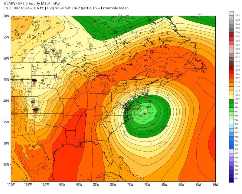
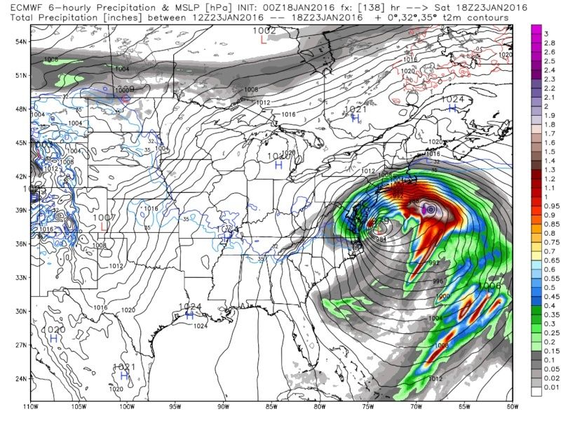
Looking at the Euro surface maps it appears there be one of two things happening here. Either convective feedback or the LP is becoming occluded.

 " />
" />

 " />
" />
Notice how At hrs 138-144 there is a second center N and east of the main center of LP. The bulk of the Moisture shield is actually around the LP center further to the NE rather than the one just off the coast. I believe there is a reason for this and I will explain.

 " />
" />
If this is a convective feedback problem than it means the model is having trouble with where to place the center of the LP and everything looks spread out. As we move closer this should correct and everything should consolidate into one large precip shield, and the expansion of higher snow totals back NW to interior areas should occur.
However, I believe this is actually the latter, occlusion of the main Low. When I look at the 500mb charts I see that the main area of LP just off the Delmarva at hr 144 it is nearly beneath it. This in essence occludes the surface LP AKA caps it off over top. What I mean by that is the divergence(air moving away from itself) over the top of the surface LP needed to strengthen it is no more. The reason being is that now by hrs 138- 144 the upper level LP, with counterclockwise air rushing towards its center, is directly over top of the surface LP center, which also has counter clockwise winds rushing towards its center.
As the air rushing into the center of any LP collides with itself it is going to either move up or down right? At the surface there is nowhere for this colliding air to go but up because of the ground which strengthens vertical upward motion deepening the LP and enhancing convection and precip. However because an upper level LP also has air crashing into itself at the center it does not have the ground to limit which direction that air moves. So while some air will move up, you will also get air to move down causing sinking air at its center. If there is a surface LP benath this sinking air it will essentially limit the rising air of the surface LP effectively "occluding it, or capping it off.
The best analogy for this is your fireplace. If the flue of your fireplace is wide open then the warm air from the fire(surface LP) is allowed to rise rapidly and exit the chimney maximally. If you close the flue partially or completely(surface LP slides under the ULL) you limit the rising warm air and the flames become dampened until it essentially burns(snows) itself out.
Here you can see the surface LP is sitting right under the ULL by hr 144

 " />
" />

 " />
" />
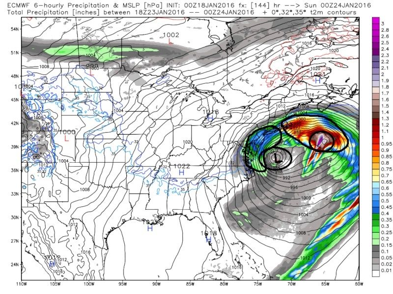
The reason we get enhanced precip to the NE and a second center of LP is that we have two jet streaks at 300mb. Now while the main area of LP is being dampened by upper level convergence, ULL sitting on top of it, that second area of LP and enhanced precip is because of enhanced upper level divergence. The L front quadrant and the R rear quadrants of a jet streak as a general rule will lead to enhanced upper level divergence in these locations(small black circle in image below). If you have divergence aloft then you can only infer that the air to replace it comes from underneath it at the surface. Rising air as we all know lowers pressures and enhances convection and precip.

This is why I think we see what we see on the Euro. I see it on the other models as well but believe the Euro is handling this the best at the moment. We will have to see how this trends going forward and the timing of the occlusion of the main low. This may be a limiting factor in just how far interior the expansion of the precip field can make it, leading to sharp cutoffs.
 " />
" /> " />
" />Notice how At hrs 138-144 there is a second center N and east of the main center of LP. The bulk of the Moisture shield is actually around the LP center further to the NE rather than the one just off the coast. I believe there is a reason for this and I will explain.
 " />
" />If this is a convective feedback problem than it means the model is having trouble with where to place the center of the LP and everything looks spread out. As we move closer this should correct and everything should consolidate into one large precip shield, and the expansion of higher snow totals back NW to interior areas should occur.
However, I believe this is actually the latter, occlusion of the main Low. When I look at the 500mb charts I see that the main area of LP just off the Delmarva at hr 144 it is nearly beneath it. This in essence occludes the surface LP AKA caps it off over top. What I mean by that is the divergence(air moving away from itself) over the top of the surface LP needed to strengthen it is no more. The reason being is that now by hrs 138- 144 the upper level LP, with counterclockwise air rushing towards its center, is directly over top of the surface LP center, which also has counter clockwise winds rushing towards its center.
As the air rushing into the center of any LP collides with itself it is going to either move up or down right? At the surface there is nowhere for this colliding air to go but up because of the ground which strengthens vertical upward motion deepening the LP and enhancing convection and precip. However because an upper level LP also has air crashing into itself at the center it does not have the ground to limit which direction that air moves. So while some air will move up, you will also get air to move down causing sinking air at its center. If there is a surface LP benath this sinking air it will essentially limit the rising air of the surface LP effectively "occluding it, or capping it off.
The best analogy for this is your fireplace. If the flue of your fireplace is wide open then the warm air from the fire(surface LP) is allowed to rise rapidly and exit the chimney maximally. If you close the flue partially or completely(surface LP slides under the ULL) you limit the rising warm air and the flames become dampened until it essentially burns(snows) itself out.
Here you can see the surface LP is sitting right under the ULL by hr 144
 " />
" /> " />
" />The reason we get enhanced precip to the NE and a second center of LP is that we have two jet streaks at 300mb. Now while the main area of LP is being dampened by upper level convergence, ULL sitting on top of it, that second area of LP and enhanced precip is because of enhanced upper level divergence. The L front quadrant and the R rear quadrants of a jet streak as a general rule will lead to enhanced upper level divergence in these locations(small black circle in image below). If you have divergence aloft then you can only infer that the air to replace it comes from underneath it at the surface. Rising air as we all know lowers pressures and enhances convection and precip.

This is why I think we see what we see on the Euro. I see it on the other models as well but believe the Euro is handling this the best at the moment. We will have to see how this trends going forward and the timing of the occlusion of the main low. This may be a limiting factor in just how far interior the expansion of the precip field can make it, leading to sharp cutoffs.
Last edited by sroc4 on Mon Jan 18, 2016 8:05 am; edited 2 times in total
_________________
"In weather and in life, there's no winning and losing; there's only winning and learning."
WINTER 2012/2013 TOTALS 43.65"WINTER 2017/2018 TOTALS 62.85" WINTER 2022/2023 TOTALS 4.9"
WINTER 2013/2014 TOTALS 64.85"WINTER 2018/2019 TOTALS 14.25" WINTER 2023/2024 TOTALS 13.1"
WINTER 2014/2015 TOTALS 71.20"WINTER 2019/2020 TOTALS 6.35" WINTER 2024/2025 TOTALS 0.00
WINTER 2015/2016 TOTALS 35.00"WINTER 2020/2021 TOTALS 37.75"
WINTER 2016/2017 TOTALS 42.25"WINTER 2021/2022 TOTALS 31.65"

sroc4- Admin

- Posts : 8458
Reputation : 302
Join date : 2013-01-07
Location : Wading River, LI
 Re: 01/22/16-01/23/16 Update #1 - Historic Storm Possible
Snowfall wrote:When u wake up to 6 pages from a thread frank started last night it's big where's sroc
I have decided to remain relatively quite until Tuesday, mostly for superstitious reason, however, I did offer some analysis above. I still want to get to the Tuesday Wed time frame to go all in since our energy is not onshore yet. That said I am 90% on board with a major storm to affect the entire area with details yet to be determined.
_________________
"In weather and in life, there's no winning and losing; there's only winning and learning."
WINTER 2012/2013 TOTALS 43.65"WINTER 2017/2018 TOTALS 62.85" WINTER 2022/2023 TOTALS 4.9"
WINTER 2013/2014 TOTALS 64.85"WINTER 2018/2019 TOTALS 14.25" WINTER 2023/2024 TOTALS 13.1"
WINTER 2014/2015 TOTALS 71.20"WINTER 2019/2020 TOTALS 6.35" WINTER 2024/2025 TOTALS 0.00
WINTER 2015/2016 TOTALS 35.00"WINTER 2020/2021 TOTALS 37.75"
WINTER 2016/2017 TOTALS 42.25"WINTER 2021/2022 TOTALS 31.65"

sroc4- Admin

- Posts : 8458
Reputation : 302
Join date : 2013-01-07
Location : Wading River, LI
 Re: 01/22/16-01/23/16 Update #1 - Historic Storm Possible
Still worried about a southern trend with what the ECM showed last night even though it wad personally still a great run. Have to watch the details. Lots of time to trend from a '96 challenger to a wide right too late Nemo. (Different setup I know, better example would be early Feb 2010 where I got 7", DC got like 3 feet, Philly almost 2 feet and NYC barely anything.... As I said dont worry about cutting or warm air, we want this to close off and stallright off New Jersey to put us in the best banding. Not down by DE, not way out in the ocean. Literally just off of ACY tucked in between NJ and LI parked would slam the whole I95 corridor down to the coast.
NjWeatherGuy- Advanced Forecaster

- Posts : 4100
Reputation : 28
Join date : 2013-01-06
Location : Belle Mead, NJ
 Re: 01/22/16-01/23/16 Update #1 - Historic Storm Possible
Nice post above, Sroc. Not trying to be an a$$, but there are a couple of small details that aren't quite right, but it does get the point across. Anyway, I'm totally with you in the sense of not getting hopes up. I do not like the southeast trend of the Euro Op and it's ensemble, and the new look they give to the western ridge. The GFS still looks like it will continue to correct northwest, based upon the ensemble clustering of 500 hPa spaghettis showing a sharper trough in relation the other ensemble mean and even the Op. Lastly, it would still appear that the Canadian ensemble doesn't know what it wants to do, and is a total mess haha Really don't want to see that western ridge begin to collapse, but unfortunately, I think we will still end up with a further southeast track. We shall see.
rb924119- Meteorologist

- Posts : 7112
Reputation : 195
Join date : 2013-02-06
Age : 32
Location : Greentown, Pa
 Re: 01/22/16-01/23/16 Update #1 - Historic Storm Possible
rb924119 wrote:Nice post above, Sroc. Not trying to be an a$$, but there are a couple of small details that aren't quite right, but it does get the point across. Anyway, I'm totally with you in the sense of not getting hopes up. I do not like the southeast trend of the Euro Op and it's ensemble, and the new look they give to the western ridge. The GFS still looks like it will continue to correct northwest, based upon the ensemble clustering of 500 hPa spaghettis showing a sharper trough in relation the other ensemble mean and even the Op. Lastly, it would still appear that the Canadian ensemble doesn't know what it wants to do, and is a total mess haha Really don't want to see that western ridge begin to collapse, but unfortunately, I think we will still end up with a further southeast track. We shall see.
When looking at the low locations on the euro ens there is a very small number of LP well S of the mean. I believe this small cluster is skewing the mean a tad further south and east. The main cluster seems to be tucked up inside NW of the mean. We shall see how the next 48hrs shakes out.
_________________
"In weather and in life, there's no winning and losing; there's only winning and learning."
WINTER 2012/2013 TOTALS 43.65"WINTER 2017/2018 TOTALS 62.85" WINTER 2022/2023 TOTALS 4.9"
WINTER 2013/2014 TOTALS 64.85"WINTER 2018/2019 TOTALS 14.25" WINTER 2023/2024 TOTALS 13.1"
WINTER 2014/2015 TOTALS 71.20"WINTER 2019/2020 TOTALS 6.35" WINTER 2024/2025 TOTALS 0.00
WINTER 2015/2016 TOTALS 35.00"WINTER 2020/2021 TOTALS 37.75"
WINTER 2016/2017 TOTALS 42.25"WINTER 2021/2022 TOTALS 31.65"

sroc4- Admin

- Posts : 8458
Reputation : 302
Join date : 2013-01-07
Location : Wading River, LI

Quietace- Meteorologist - Mod

- Posts : 3689
Reputation : 33
Join date : 2013-01-07
Age : 27
Location : Point Pleasant, NJ
 Re: 01/22/16-01/23/16 Update #1 - Historic Storm Possible
When looking at the low locations on the euro ens there is a very small number of LP well S of the mean. I believe this small cluster is skewing the mean a tad further south and east. The main cluster seems to be tucked up inside NW of the mean. We shall see how the next 48hrs shakes out.
Yeah I saw that. But, I'm looking at the 500 hPa spaghettis. For example, take a look at yesterday's 12z (top) versus last night's 00z (bottom):


See how there were a lot of members more amplified than the mean and Op at 12z? Now, there's actually a cluster of heights that is broader than 12z. We want the clustering inside of the mean, with it being skewed ONLY by outliers that are broader with the trough, not vice-versa. Hopefully it only a hiccup.
rb924119- Meteorologist

- Posts : 7112
Reputation : 195
Join date : 2013-02-06
Age : 32
Location : Greentown, Pa
 Re: 01/22/16-01/23/16 Update #1 - Historic Storm Possible
Comparatively the 6z GEFS are similarly clustered, with less south of the mean.

Quietace- Meteorologist - Mod

- Posts : 3689
Reputation : 33
Join date : 2013-01-07
Age : 27
Location : Point Pleasant, NJ
 Re: 01/22/16-01/23/16 Update #1 - Historic Storm Possible
sroc4 wrote:rb924119 wrote:Nice post above, Sroc. Not trying to be an a$$, but there are a couple of small details that aren't quite right, but it does get the point across. Anyway, I'm totally with you in the sense of not getting hopes up. I do not like the southeast trend of the Euro Op and it's ensemble, and the new look they give to the western ridge. The GFS still looks like it will continue to correct northwest, based upon the ensemble clustering of 500 hPa spaghettis showing a sharper trough in relation the other ensemble mean and even the Op. Lastly, it would still appear that the Canadian ensemble doesn't know what it wants to do, and is a total mess haha Really don't want to see that western ridge begin to collapse, but unfortunately, I think we will still end up with a further southeast track. We shall see.
When looking at the low locations on the euro ens there is a very small number of LP well S of the mean. I believe this small cluster is skewing the mean a tad further south and east. The main cluster seems to be tucked up inside NW of the mean. We shall see how the next 48hrs shakes out.
LOL! Did somebody say "S and E?"

docstox12- Wx Statistician Guru

- Posts : 8615
Reputation : 222
Join date : 2013-01-07
Age : 74
Location : Monroe NY
 Re: 01/22/16-01/23/16 Update #1 - Historic Storm Possible
Quietace wrote:Comparatively the 6z GEFS are similarly clustered, with less south of the mean.
Yup, which is why I expect the mean to continue to correct northwest in successive runs. 00z (top) versus 06z (bottom):


There's a good portion that are inside the mean and Op, which is a GREAT sign, and honestly, what I hope the Euro corrects to lol
rb924119- Meteorologist

- Posts : 7112
Reputation : 195
Join date : 2013-02-06
Age : 32
Location : Greentown, Pa
 Re: 01/22/16-01/23/16 Update #1 - Historic Storm Possible
The Para Euro has been NW of the OP since it has shown the system, yet the 0z data is not available on WXbell yet so I cant compare yet.rb924119 wrote:Quietace wrote:Comparatively the 6z GEFS are similarly clustered, with less south of the mean.
Yup, which is why I expect the mean to continue to correct northwest in successive runs. 00z (top) versus 06z (bottom):
There's a good portion that are inside the mean and Op, which is a GREAT sign, and honestly, what I hope the Euro corrects to lol

Quietace- Meteorologist - Mod

- Posts : 3689
Reputation : 33
Join date : 2013-01-07
Age : 27
Location : Point Pleasant, NJ
 Re: 01/22/16-01/23/16 Update #1 - Historic Storm Possible
Oh good, it's not just me then Ace ahaha
rb924119- Meteorologist

- Posts : 7112
Reputation : 195
Join date : 2013-02-06
Age : 32
Location : Greentown, Pa
 Re: 01/22/16-01/23/16 Update #1 - Historic Storm Possible
FWIW, TWC just had their report and hinting at the "B" word saying a stay at home snow storm sat, said a foot in DC maybe 6 inches north of there (what are they looking at?), and the winds will be high and come in off ocean warm temps to just around freezing so its not go be really cold? What are they looking at and btw they were talk bout euro. But needless to say media is chirping i give it another day or two b4 the panic sets in. If you all know frankie from nova scotia on youtube (he is autitistic) I love to watch his videos, you wanna talk about weather excitement! I am trying so hard to temper and sorry for my all out excitement pour out lat night lets just say I was "out, having a bit too much fun lol" and checking on my phone.
Sorry OT but if anyone saw ttwc within the past hr or seen news that 14 car accident that has the bronx river parkway shutdown in yonkers is the exit near my mother in law. Just crazy highwway will be closed until tuesday!
Sorry OT but if anyone saw ttwc within the past hr or seen news that 14 car accident that has the bronx river parkway shutdown in yonkers is the exit near my mother in law. Just crazy highwway will be closed until tuesday!

jmanley32- Senior Enthusiast

- Posts : 20646
Reputation : 108
Join date : 2013-12-12
Age : 43
Location : Yonkers, NY
 Re: 01/22/16-01/23/16 Update #1 - Historic Storm Possible
jmanley32 wrote:FWIW, TWC just had their report and hinting at the "B" word saying a stay at home snow storm sat, said a foot in DC maybe 6 inches north of there (what are they looking at?), and the winds will be high and come in off ocean warm temps to just around freezing so its not go be really cold? What are they looking at and btw they were talk bout euro. But needless to say media is chirping i give it another day or two b4 the panic sets in. If you all know frankie from nova scotia on youtube (he is autitistic) I love to watch his videos, you wanna talk about weather excitement! I am trying so hard to temper and sorry for my all out excitement pour out lat night lets just say I was "out, having a bit too much fun lol" and checking on my phone.
Sorry OT but if anyone saw ttwc within the past hr or seen news that 14 car accident that has the bronx river parkway shutdown in yonkers is the exit near my mother in law. Just crazy highwway will be closed until tuesday!
Jman, just for you, here's the extended GFS MOS data for NYC, which is a tabled model output for the weather station's location. The numbers I have highlighted are the progged sustained wind speeds in knots. Would this quench your thirst for wind? haha

rb924119- Meteorologist

- Posts : 7112
Reputation : 195
Join date : 2013-02-06
Age : 32
Location : Greentown, Pa
 Re: 01/22/16-01/23/16 Update #1 - Historic Storm Possible
rb924119 wrote:jmanley32 wrote:FWIW, TWC just had their report and hinting at the "B" word saying a stay at home snow storm sat, said a foot in DC maybe 6 inches north of there (what are they looking at?), and the winds will be high and come in off ocean warm temps to just around freezing so its not go be really cold? What are they looking at and btw they were talk bout euro. But needless to say media is chirping i give it another day or two b4 the panic sets in. If you all know frankie from nova scotia on youtube (he is autitistic) I love to watch his videos, you wanna talk about weather excitement! I am trying so hard to temper and sorry for my all out excitement pour out lat night lets just say I was "out, having a bit too much fun lol" and checking on my phone.
Sorry OT but if anyone saw ttwc within the past hr or seen news that 14 car accident that has the bronx river parkway shutdown in yonkers is the exit near my mother in law. Just crazy highwway will be closed until tuesday!
Jman, just for you, here's the extended GFS MOS data for NYC, which is a tabled model output for the weather station's location. The numbers I have highlighted are the progged sustained wind speeds in knots. Would this quench your thirst for wind? haha
Jeeze is that sustained? 44mph (or is it kts) for a period of the event. Ummm ya lol

jmanley32- Senior Enthusiast

- Posts : 20646
Reputation : 108
Join date : 2013-12-12
Age : 43
Location : Yonkers, NY
 Re: 01/22/16-01/23/16 Update #1 - Historic Storm Possible
Sustained and in knots, so roughly 50 m/h sustained winds lmao
rb924119- Meteorologist

- Posts : 7112
Reputation : 195
Join date : 2013-02-06
Age : 32
Location : Greentown, Pa
 Re: 01/22/16-01/23/16 Update #1 - Historic Storm Possible
This storm is going to give us agita. There will be waffling over the next 2 days that will severely cut-off the snow amounts for those west and north of I-95. I have a feeling the ridge may go flat at a bad time for those area and the storm track may end up further east. I hope I am wrong for the sake of those places, but we'll see. I just do not trust the progressive flow at this time. The saving grace may be the block from the huge 50/50. But that mean we'll need organized phasing, not this double-barrel low stuff models are showing.
_________________
_______________________________________________________________________________________________________
CLICK HERE to view NJ Strong Snowstorm Classifications
Page 6 of 26 •  1 ... 5, 6, 7 ... 16 ... 26
Page 6 of 26
Permissions in this forum:
You cannot reply to topics in this forum
 Home
Home


