01/23/16 Storm Update #4 - A Tough 1st Call
+58
Ferndue21
Snow88
Ronniek
CPcantmeasuresnow
nyrfan31
Mathgod55
Aerojet514
Sunflowers138
Deweydave
chief7
Vinnydula
Snowfall
SNOW MAN
JDKWeather
Grselig
essexcountypete
docstox12
dsvinos
nutleyblizzard
mwilli5783
snowlover78
Radz
Quietace
jake732
Joe Snow
mako460
Bkdude
pdubz
oldtimer
rb924119
Artechmetals
sroc4
billg315
Abba701
Dunnzoo
Sanchize06
Math23x7
lglickman1
algae888
2004blackwrx
Biggin23
gigs68
weatherwatchermom
WeatherBob
BARBIEFLY
Dtone
RJB8525
amugs
skinsfan1177
frank 638
NjWeatherGuy
jimv45
hyde345
devsman
SoulSingMG
jmanley32
snow247
Frank_Wx
62 posters
Page 21 of 29
Page 21 of 29 •  1 ... 12 ... 20, 21, 22 ... 25 ... 29
 Keep the faith
Hey guys...been a while since i've been on but i've been here reading all your posts and keeping up. I now work during the storms clearing city streets. I know this probably belongs on banter but hopefully this keeps some off the roof! I totally understand everyone's frustration here...i'm a snow junky too! We're all born that way! But never give up hope till the storms actually gone and the clouds are breaking! I always bring up the '96 storm...the king in my lifetime! I'm in Queens and that baby gave us 30"!! The big difference with that storm was the arctic high to our NW was extreme....it was 7 deg that morning! I live the cold but i never felt that cold in my life when i went out that morning! The dampness went through your bones and that wonderful smell of the snow coming!! That temp assured us that no matter how close that storm got most likely there would be no rain/ snow line issues! And every beautiful flake that fell stuck immediately! Back then all i had was the weather channel...when they actually stuck to weather!! And a little noaa weather radio...yeah ,i'm old! No computer so my only radar outlet was the WC's "local on the 8's"! Everyone went to bed the night before storm hit hearing 3-6" and possibly 6-12" forecast. The jackpot zone was over DC and PHI...24+. I'll never forget stayin up all night to watch the live winter weather updates they had every hour or so. Right around 2am Paul Kocin came on with the latest comp model updates...telling us that with the latest information they now need to shift the jackpot totals NE!! That the bullseye for this storm is now over NYC!! More times then not in my life when we have gotten our monster storms that has been the case....heaviest totals to our south and west....head for the hills its coming! Especially when they say Boston may get shut out with this one....Boston rarely gets shut out!! Mother nature loves the snow lovers up there!!! So keep faith guys...theres always time for it to change! Keep the spirit of '96 alive!!
Last edited by Aerojet514 on Thu Jan 21, 2016 2:29 pm; edited 2 times in total
Aerojet514- Posts : 29
Join date : 2014-02-04
 Re: 01/23/16 Storm Update #4 - A Tough 1st Call
I'm certainly not. We're seeing something on the global models which we really don't know how to decipher. How can you explain convection just jumping like that. Sure the storm is feeling the effects of the gradient, but why doesn't the convection just slide due east? A big red flag which we all know by now, is the upper levels depiction look great and only improves with each ensuing run. It's just not reflecting that on the surface maps. Then you have the hi-res models consistently showing big hits. So you now have two model camps. One would think that one side will blink by 12z tomorrow. My gut tells me the EURO and GFS will bump up north another 50 miles which would put NYC metro in 12+ inches.sroc4 wrote:Quietace wrote:The RGEM, RPM, and NAM show very similar outcomes. No true jump to convection.
Lower Res Globals due. Have to wait and see
Exactly. There is no sense jumping off the same bridge that many of you have jumped off this time yesterday. Clearly there is a ton of variability occurring here. Just like yesterday, pause for serious concern, but there is still enough time to jog things back 50miles north which will make a huge diff if it occurs. Dont JUMP!!!!!
nutleyblizzard- Senior Enthusiast

- Posts : 1963
Join date : 2014-01-30
 Re: 01/23/16 Storm Update #4 - A Tough 1st Call
SREFS!!!!!!!!!!!!!!!
_________________
Mugs
AKA:King: Snow Weenie
Self Proclaimed
WINTER 2014-15 : 55.12" +.02 for 6 coatings (avg. 35")
WINTER 2015-16 Total - 29.8" (Avg 35")
WINTER 2016-17 : 39.5" so far

amugs- Advanced Forecaster - Mod

- Posts : 15154
Reputation : 213
Join date : 2013-01-07
Age : 54
Location : Hillsdale,NJ
 Re: 01/23/16 Storm Update #4 - A Tough 1st Call

_________________
Mugs
AKA:King: Snow Weenie
Self Proclaimed
WINTER 2014-15 : 55.12" +.02 for 6 coatings (avg. 35")
WINTER 2015-16 Total - 29.8" (Avg 35")
WINTER 2016-17 : 39.5" so far

amugs- Advanced Forecaster - Mod

- Posts : 15154
Reputation : 213
Join date : 2013-01-07
Age : 54
Location : Hillsdale,NJ
 Re: 01/23/16 Storm Update #4 - A Tough 1st Call

_________________
Mugs
AKA:King: Snow Weenie
Self Proclaimed
WINTER 2014-15 : 55.12" +.02 for 6 coatings (avg. 35")
WINTER 2015-16 Total - 29.8" (Avg 35")
WINTER 2016-17 : 39.5" so far

amugs- Advanced Forecaster - Mod

- Posts : 15154
Reputation : 213
Join date : 2013-01-07
Age : 54
Location : Hillsdale,NJ
 Re: 01/23/16 Storm Update #4 - A Tough 1st Call
nutleyblizzard wrote:I'm certainly not. We're seeing something on the global models which we really don't know how to decipher. How can you explain convection just jumping like that. Sure the storm is feeling the effects of the gradient, but why doesn't the convection just slide due east? A big red flag which we all know by now, is the upper levels depiction look great and only improves with each ensuing run. It's just not reflecting that on the surface maps. Then you have the hi-res models consistently showing big hits. So you now have two model camps. One would think that one side will blink by 12z tomorrow. My gut tells me the EURO and GFS will bump up north another 50 miles which would put NYC metro in 12+ inches.sroc4 wrote:Quietace wrote:The RGEM, RPM, and NAM show very similar outcomes. No true jump to convection.
Lower Res Globals due. Have to wait and see
Exactly. There is no sense jumping off the same bridge that many of you have jumped off this time yesterday. Clearly there is a ton of variability occurring here. Just like yesterday, pause for serious concern, but there is still enough time to jog things back 50miles north which will make a huge diff if it occurs. Dont JUMP!!!!!
I am going to agree with this, every year there are some problems with the BIG 3 handling the energy and all its parameters. My hunch is that this one plays out

Joe Snow- Pro Enthusiast

- Posts : 933
Reputation : 7
Join date : 2014-02-12
Age : 62
Location : Sanford Florida, Fmrly Kings Park, NY
 Re: 01/23/16 Storm Update #4 - A Tough 1st Call
amugs wrote:
Looks like its giving Long Island the purple finger

gigs68- Posts : 142
Reputation : 3
Join date : 2013-01-16
Location : Commack, NY (NW Suffolk)
 Re: 01/23/16 Storm Update #4 - A Tough 1st Call
Wetter, Not jumping to the convection - third run in a row now.
BIG MOMMA PLEASE GIVE US THIS SOLUTION!!
BIG MOMMA PLEASE GIVE US THIS SOLUTION!!
_________________
Mugs
AKA:King: Snow Weenie
Self Proclaimed
WINTER 2014-15 : 55.12" +.02 for 6 coatings (avg. 35")
WINTER 2015-16 Total - 29.8" (Avg 35")
WINTER 2016-17 : 39.5" so far

amugs- Advanced Forecaster - Mod

- Posts : 15154
Reputation : 213
Join date : 2013-01-07
Age : 54
Location : Hillsdale,NJ
 Re: 01/23/16 Storm Update #4 - A Tough 1st Call
gigs68 wrote:amugs wrote:
Looks like its giving Long Island the purple finger
LOL

RJB8525- Senior Enthusiast

- Posts : 1994
Reputation : 28
Join date : 2013-02-06
Age : 38
Location : Hackettstown, NJ
 Re: 01/23/16 Storm Update #4 - A Tough 1st Call
RJB8525 wrote:gigs68 wrote:amugs wrote:
Looks like its giving Long Island the purple finger
LOL
LOL! Does this model have snow totals?
dsvinos- Posts : 68
Reputation : 4
Join date : 2014-01-02
Age : 56
Location : Marlboro NJ
 Re: 01/23/16 Storm Update #4 - A Tough 1st Call
Relax fella's! I've lived on the south shore waters of Long Island for over 50 years and can tell you that with even the best weather models and guidance, Nor'easter's are full of surprises and leave a lot of egg on forecasters faces. Enjoy the ride!

Mathgod55- Posts : 60
Reputation : 0
Join date : 2013-01-08
Location : West Islip, NyY
 Re: 01/23/16 Storm Update #4 - A Tough 1st Call
jake732 wrote:mugs,
do we trust the srefs ever??
Yes they are short range meoscale model that we use for winter storms to gauge LP placement and qpf - hi res model - sniffs out the goods.
I think the convection feedback issue is more than an issue here I believe it is a problem with our globals. I can't see why the LP jumps due east at hr 54-57 when everything points it should take NNE path - fricking amazing.
_________________
Mugs
AKA:King: Snow Weenie
Self Proclaimed
WINTER 2014-15 : 55.12" +.02 for 6 coatings (avg. 35")
WINTER 2015-16 Total - 29.8" (Avg 35")
WINTER 2016-17 : 39.5" so far

amugs- Advanced Forecaster - Mod

- Posts : 15154
Reputation : 213
Join date : 2013-01-07
Age : 54
Location : Hillsdale,NJ
 Re: 01/23/16 Storm Update #4 - A Tough 1st Call
Heavy lean to a tucked in solution as all meoscale models are showing


_________________
Mugs
AKA:King: Snow Weenie
Self Proclaimed
WINTER 2014-15 : 55.12" +.02 for 6 coatings (avg. 35")
WINTER 2015-16 Total - 29.8" (Avg 35")
WINTER 2016-17 : 39.5" so far

amugs- Advanced Forecaster - Mod

- Posts : 15154
Reputation : 213
Join date : 2013-01-07
Age : 54
Location : Hillsdale,NJ
 Re: 01/23/16 Storm Update #4 - A Tough 1st Call
Didn't the short range models nail Juno last year while the long range models (specifically the Euro) showed the Tri-state getting hammered? Just some food for thought, a lot of the short range models are solid for the area.

nyrfan31- Posts : 45
Reputation : 0
Join date : 2013-01-13
Age : 30
Location : Carmel, NY
 Re: 01/23/16 Storm Update #4 - A Tough 1st Call
So amugs your saying there's a chance!
jimv45- Senior Enthusiast

- Posts : 1168
Reputation : 36
Join date : 2013-09-20
Location : Hopewell jct.
 Re: 01/23/16 Storm Update #4 - A Tough 1st Call
It really is amazing the difference in the mesoscale models and the globals with 48 hours to start time in this area. Its not just a small difference but a huge difference in some cases. It will be interesting to see how this all plays out. I'm still of the opinion that the HV gets very little.
hyde345- Pro Enthusiast

- Posts : 1084
Reputation : 48
Join date : 2013-01-08
Location : Hyde Park, NY
 Re: 01/23/16 Storm Update #4 - A Tough 1st Call
jimv45 wrote:So amugs your saying there's a chance!


RJB8525- Senior Enthusiast

- Posts : 1994
Reputation : 28
Join date : 2013-02-06
Age : 38
Location : Hackettstown, NJ
 Re: 01/23/16 Storm Update #4 - A Tough 1st Call
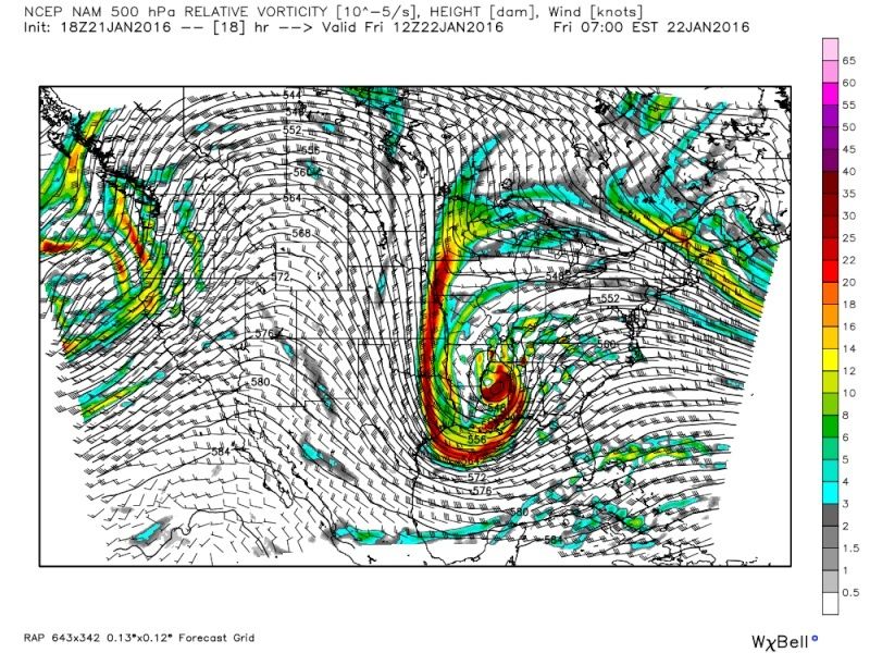
Latest RAP HR 18


Quietace- Meteorologist - Mod

- Posts : 3689
Reputation : 33
Join date : 2013-01-07
Age : 27
Location : Point Pleasant, NJ
 Re: 01/23/16 Storm Update #4 - A Tough 1st Call
hyde don't give up yet!! Again I have never seen the sharop cutoffs like this it could be right but by tonight i think it will be better how much for us will see!!
jimv45- Senior Enthusiast

- Posts : 1168
Reputation : 36
Join date : 2013-09-20
Location : Hopewell jct.
 Re: 01/23/16 Storm Update #4 - A Tough 1st Call
With the placement of the low now what model has been the most on point?

Vinnydula- Pro Enthusiast

- Posts : 778
Reputation : 8
Join date : 2013-12-12
Location : Dobbs ferry
 Re: 01/23/16 Storm Update #4 - A Tough 1st Call
Also what models are the best 48 hours out?

Vinnydula- Pro Enthusiast

- Posts : 778
Reputation : 8
Join date : 2013-12-12
Location : Dobbs ferry
 Re: 01/23/16 Storm Update #4 - A Tough 1st Call
. I agree this is local model time that's what I call them I sat in front of the tv and watch heavy bands come all the way to queens and like they just turned backnyrfan31 wrote:Didn't the short range models nail Juno last year while the long range models (specifically the Euro) showed the Tri-state getting hammered? Just some food for thought, a lot of the short range models are solid for the area.
Snowfall- Posts : 59
Reputation : 0
Join date : 2015-12-31
 Re: 01/23/16 Storm Update #4 - A Tough 1st Call
Waiting on SREF individual members, more telling than general spread...
NjWeatherGuy- Advanced Forecaster

- Posts : 4100
Reputation : 28
Join date : 2013-01-06
Location : Belle Mead, NJ

snow247- Pro Enthusiast

- Posts : 2417
Reputation : 0
Join date : 2014-08-27
Location : Mount Ivy, NY - Elevation 545'
 Re: 01/23/16 Storm Update #4 - A Tough 1st Call
Ughhhhhh I'm trying so hard to think positively but this just reminds me of all those storms that year DC/BM had Snowmegedon. I feel like we are sorta grasping at straws because of how great this looked on Sun/Mon. :-/

SoulSingMG- Senior Enthusiast

- Posts : 2853
Reputation : 74
Join date : 2013-12-11
Location : Long Island City, NY
Page 21 of 29 •  1 ... 12 ... 20, 21, 22 ... 25 ... 29
Page 21 of 29
Permissions in this forum:
You cannot reply to topics in this forum
 Home
Home