January 23, 2016 Roidzilla Observations
+88
Nyi1058
track17
mandaface
New Yorker 234
79cj7jeep
dsvinos
Michael Rehman
tigernumba1
nyrfan31
bas1gun
deadrabbit79
AMD95
HEATMISER
Cyanide02Z06
Ronniek
mako460
Fededle22
Artechmetals
anthony joseph
lglickman1
dkodgis
SoulSingMG
sabamfa
keliza52
ltledy23
brownie
mancave25
hyde345
elkiehound
mwilli5783
dgallag
rb924119
2004blackwrx
Grselig
Gator99
Snow88
WeatherBob
meeka312
Mathgod55
mmanisca
bloc1357
Sparky Sparticles
Dave1978
down tines
JoeBx82
abayoumi21
MikeFr
algae888
Scullybutcher
Vinnydula
Dunnzoo
oldtimer
gigs68
nutleyblizzard
snowlover 12345
SNOW MAN
Math23x7
snowlover78
Snowfall
jmanley32
Dtone
UnionWX
devsman
frank 638
amugs
shawnerak
weatherwatchermom
crippo84
sroc4
GreyBeard
Quietace
roccuweather
petep1000
docstox12
Angela0621
Biggin23
SkiSeadooJoe
jimv45
CPcantmeasuresnow
Frank_Wx
Radz
Joe Snow
RJB8525
xtingu
skinsfan1177
NjWeatherGuy
billg315
snow247
92 posters
Page 12 of 40
Page 12 of 40 •  1 ... 7 ... 11, 12, 13 ... 26 ... 40
 Re: January 23, 2016 Roidzilla Observations
Wheres Frank?
WeatherBob- Meteorologist

- Posts : 683
Join date : 2013-12-13
 Re: January 23, 2016 Roidzilla Observations
Getting shafted up here. Been snowing since 1am and I have 1.25-1.5" lol
rb924119- Meteorologist

- Posts : 7117
Join date : 2013-02-06
 Re: January 23, 2016 Roidzilla Observations
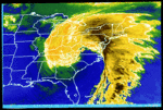
weatherwatchermom wrote:http://earth.nullschool.net/#current/wind/surface/level/orthographic=-79.82,35.49,676/loc=-74.453,40.888
love looking at this
Memorizing!
Radz- Pro Enthusiast

- Posts : 1028
Reputation : 17
Join date : 2013-01-12
Location : Cortlandt Manor NY
 Re: January 23, 2016 Roidzilla Observations
Over o foot here with two foot drifts. Temp at 31.8. Power has been flickering on and off in the last half hour. Still a long way to go.

SkiSeadooJoe- Posts : 95
Reputation : 8
Join date : 2013-01-08
Age : 52
Location : Toms River, NJ
 Re: January 23, 2016 Roidzilla Observations
weatherwatchermom wrote:Lee Goldberg...just said that the Model not a model might end up being correct...some places NNJ could see up to 30 inches when all said and done...
Hi, New member here. I just watched Lee Goldberg as well. He mentioned the sweet spot could be the Morristown area. That's me. This is getting real!
With that said I wanted to thank everyone on this forum. I have been reading all week and you guys are great at what you do. This will be my goto for weather moving forward. Enjoy the storm everyone!
dgallag- Posts : 1
Reputation : 0
Join date : 2016-01-22
Age : 54
Location : Mendham NJ
 Re: January 23, 2016 Roidzilla Observations
Just measured 6 inches. Snow is light and fluffy. Good ratios. I feel if I don't dry slot, 2 feet is definitely attainable. 

nutleyblizzard- Senior Enthusiast

- Posts : 1964
Reputation : 41
Join date : 2014-01-30
Age : 58
Location : Nutley, new jersey
 Re: January 23, 2016 Roidzilla Observations
MESMERIZING! lol hate auto correct!

Radz- Pro Enthusiast

- Posts : 1028
Reputation : 17
Join date : 2013-01-12
Location : Cortlandt Manor NY
 Re: January 23, 2016 Roidzilla Observations
With the highest accumulations expected from CNJ to NNJ and NYC, that means the majority of our members are in line to be in the jackpot
https://www.njstrongweatherforum.com/h4-member-map
https://www.njstrongweatherforum.com/h4-member-map
_________________
_______________________________________________________________________________________________________
CLICK HERE to view NJ Strong Snowstorm Classifications
 Re: January 23, 2016 Roidzilla Observations
Surface:
[img] [/img]
500MB
[img]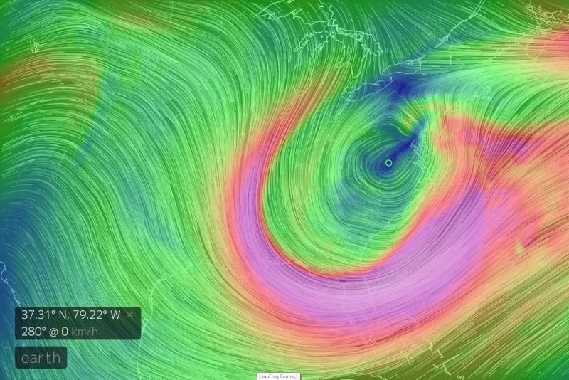 [/img]
[img]
 [/img]
500MB
[img]
 [/img]
_________________
"In weather and in life, there's no winning and losing; there's only winning and learning."
WINTER 2012/2013 TOTALS 43.65"WINTER 2017/2018 TOTALS 62.85" WINTER 2022/2023 TOTALS 4.9"
WINTER 2013/2014 TOTALS 64.85"WINTER 2018/2019 TOTALS 14.25" WINTER 2023/2024 TOTALS 13.1"
WINTER 2014/2015 TOTALS 71.20"WINTER 2019/2020 TOTALS 6.35" WINTER 2024/2025 TOTALS 0.00
WINTER 2015/2016 TOTALS 35.00"WINTER 2020/2021 TOTALS 37.75"
WINTER 2016/2017 TOTALS 42.25"WINTER 2021/2022 TOTALS 31.65"

sroc4- Admin

- Posts : 8463
Reputation : 302
Join date : 2013-01-07
Location : Wading River, LI
 Re: January 23, 2016 Roidzilla Observations
South nassau, LI. Drifts are insane. Can barely open my front door but my back door, I can see pavement. Wont even bother measuring.

devsman- Pro Enthusiast

- Posts : 424
Reputation : 4
Join date : 2014-01-01
Age : 49
Location : merrick, ny (south shore of Long Island)
 Re: January 23, 2016 Roidzilla Observations
Frank_Wx wrote:With the highest accumulations expected from CNJ to NNJ and NYC, that means the majority of our members are in line to be in the jackpot
https://www.njstrongweatherforum.com/h4-member-map
And to think I was in the cutoff area earlier!
_________________
Janet
Snowfall winter of 2023-2024 17.5"
Snowfall winter of 2022-2023 6.0"
Snowfall winter of 2021-2022 17.6" 1" sleet 2/25/22
Snowfall winter of 2020-2021 51.1"
Snowfall winter of 2019-2020 8.5"
Snowfall winter of 2018-2019 25.1"
Snowfall winter of 2017-2018 51.9"
Snowfall winter of 2016-2017 45.6"
Snowfall winter of 2015-2016 29.5"
Snowfall winter of 2014-2015 50.55"
Snowfall winter of 2013-2014 66.5"
Dunnzoo- Senior Enthusiast - Mod

- Posts : 4938
Reputation : 68
Join date : 2013-01-11
Age : 62
Location : Westwood, NJ
 Re: January 23, 2016 Roidzilla Observations
hello all what a band sitting over southern Westchester. woke up at 4 had about an inch now have at least 6" eyeballing it . WOW and the best still to come

algae888- Advanced Forecaster

- Posts : 5311
Reputation : 46
Join date : 2013-02-05
Age : 62
Location : mt. vernon, new york
 Re: January 23, 2016 Roidzilla Observations
This is what Mt Holly said about the dry slot
Mt Holly disco
NEAR TERM /UNTIL 6 PM THIS EVENING/...
630 AM UPDATE...A POTENT STORM JUST EAST OF THE VIRGINIA COAST
CONTINUES TO DEEPEN. IMPRESSIVE INFLOW AS NORTHEAST WIND GUSTS TO
55 TO 65 MPH HAVE BEEN REPORTED IN SOUTHERN DELAWARE TO THE
SOUTHEASTERN NEW JERSEY COAST. THIS WILL CONTINUE FOR AWHILE AS
MOMENTUM TRANSFER IS MAXIMIZED ON THE NORTH SIDE OF THE DEEPENING
STORM. A [url=http://forecast.weather.gov/glossary.php?word=DRY SLOT]DRY SLOT[/url] IS WORKING NORTHWARD, WHICH MAY HAVE INITIALLY
BEEN PART OF AN AREA OF GRAVITY WAVES THAT NEARED THE DELAWARE TO
SOUTHEASTERN NEW JERSEY COASTS. THIS IS ALSO WITH THE MID LEVEL
[url=http://forecast.weather.gov/glossary.php?word=DRY SLOT]DRY SLOT[/url] MOVING UP FROM THE [url=http://forecast.weather.gov/glossary.php?word=CLOSED LOW]CLOSED LOW[/url]. THIS IS HELPING TO ADD
SOME INSTABILITY AND SOME LIGHTNING STRIKES HAVE BEEN OBSERVED IN
MARYLAND, ALTHOUGH THESE HAVE BEEN SPORADIC. THE [url=http://forecast.weather.gov/glossary.php?word=LARGE SCALE]LARGE SCALE[/url] LIFT
IS PIVOTING AROUND, THEREFORE THE [url=http://forecast.weather.gov/glossary.php?word=DRY SLOT]DRY SLOT[/url] SHOULD TEND TO FILL IN.
SOME TWEAKS WERE MADE TO THE GRIDS TO KEEP UP WITH THE TRENDS,
OTHERWISE SNOW AMOUNTS REMAIN UNCHANGED ATTM.
_________________
_______________________________________________________________________________________________________
CLICK HERE to view NJ Strong Snowstorm Classifications
 Re: January 23, 2016 Roidzilla Observations
Frank_Wx wrote:With the highest accumulations expected from CNJ to NNJ and NYC, that means the majority of our members are in line to be in the jackpot
https://www.njstrongweatherforum.com/h4-member-map
I think Long Island gets in on the Jackpot numbers as well....The bands just keep pouring snow over the Island
bloc1357- Pro Enthusiast

- Posts : 344
Reputation : 10
Join date : 2013-03-05
Age : 47
Location : West Babylon, NY - 11704
 Re: January 23, 2016 Roidzilla Observations
24* and heavy snow continues. I would measure but frankly I'm too damn comfortable inside right now. Lol. But I can say this, they've been plowing the streets here regularly and since the last plow went through it looks like another 2 or 3" have accumulated on the road.

billg315- Advanced Forecaster - Mod

- Posts : 4564
Reputation : 185
Join date : 2015-01-24
Age : 50
Location : Flemington, NJ
 Re: January 23, 2016 Roidzilla Observations
Latest HRRR


_________________
_______________________________________________________________________________________________________
CLICK HERE to view NJ Strong Snowstorm Classifications
 Re: January 23, 2016 Roidzilla Observations
sroc4 wrote:Surface:" />
500MB" />
Love
_________________
_______________________________________________________________________________________________________
CLICK HERE to view NJ Strong Snowstorm Classifications
 Re: January 23, 2016 Roidzilla Observations

_________________
_______________________________________________________________________________________________________
CLICK HERE to view NJ Strong Snowstorm Classifications
 Re: January 23, 2016 Roidzilla Observations
Pouring down snow here on LI. Unbelievable. Winds gusting to near 40? 2"+ per hour in this band and it looks to be a crazy next several hours when I look at what is coming in off the ocean. Should/could see 6-8" just in the next 3 to 4 hours if these returns hold together.!!
Guest- Guest
 Re: January 23, 2016 Roidzilla Observations
Having trouble posting pic(prob because tech challenged)..will have hub post for me later...it is
BAD out there..the drifts in the middle of the street were about 2 feet.. a gust of wind almost knocked me over..no plows yet.. I measured around the yard in spots protected by wind..not sure if that is correct way..prob about 8 inches right now..wind whipping and it hurts..
26* real feel 14 winds 32mph wonder what the gusts are??

weatherwatchermom- Senior Enthusiast

- Posts : 3896
Reputation : 78
Join date : 2014-11-25
Location : Hazlet Township, NJ
 Re: January 23, 2016 Roidzilla Observations
This is def a high ratio event up ion NNJ. I had 2 in on the ground at 4:30 am. Now have 8 to 10 in , getting tough to measure with the wind, some drifts like to 1.5 to 2 feet.

WeatherBob- Meteorologist

- Posts : 683
Reputation : 83
Join date : 2013-12-13
Location : Caldwell, NJ - NW Essex County - Altitude 500 FT
 Re: January 23, 2016 Roidzilla Observations
Left Dutchess county at 5 this morning. No snow. Starting flurrying as I headed south. Light snow just started in Northern Westchester around 6. A Dusting as of now. Most snow i have seen all year. Jind of sad.
2004blackwrx- Pro Enthusiast

- Posts : 576
Reputation : 9
Join date : 2013-01-14
Location : Wappinger NY
 Re: January 23, 2016 Roidzilla Observations
central park just confirmed 6 inches of snow

weatherwatchermom- Senior Enthusiast

- Posts : 3896
Reputation : 78
Join date : 2014-11-25
Location : Hazlet Township, NJ
 Re: January 23, 2016 Roidzilla Observations
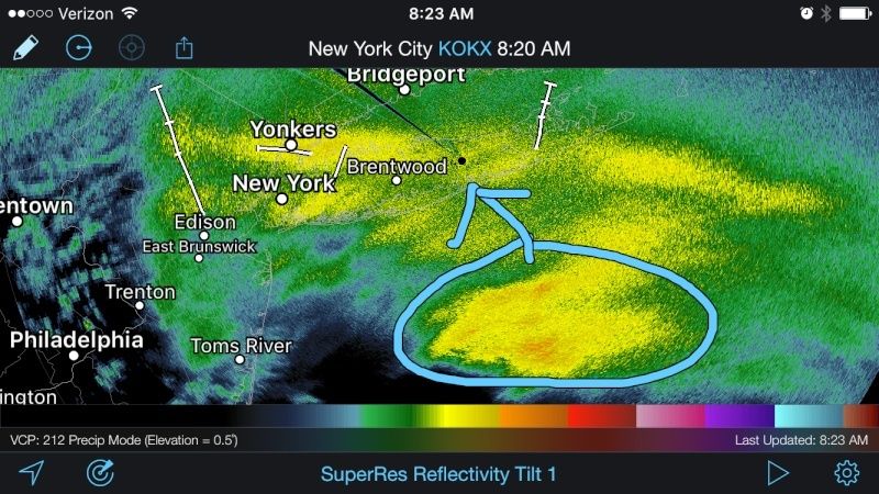
Omg if that band makes it into Suffolk county we will see 2-4" an hr and thundersnow. Lightning is in he band. 40-45dbz!!!! Please please PLEASE!!

_________________
"In weather and in life, there's no winning and losing; there's only winning and learning."
WINTER 2012/2013 TOTALS 43.65"WINTER 2017/2018 TOTALS 62.85" WINTER 2022/2023 TOTALS 4.9"
WINTER 2013/2014 TOTALS 64.85"WINTER 2018/2019 TOTALS 14.25" WINTER 2023/2024 TOTALS 13.1"
WINTER 2014/2015 TOTALS 71.20"WINTER 2019/2020 TOTALS 6.35" WINTER 2024/2025 TOTALS 0.00
WINTER 2015/2016 TOTALS 35.00"WINTER 2020/2021 TOTALS 37.75"
WINTER 2016/2017 TOTALS 42.25"WINTER 2021/2022 TOTALS 31.65"

sroc4- Admin

- Posts : 8463
Reputation : 302
Join date : 2013-01-07
Location : Wading River, LI
 Re: January 23, 2016 Roidzilla Observations
Morning ya'll!!
We'll ain't she just beautiful well he Jonas! !
I have about 4" so far and it is snowing like the f--k end out and even heavier stuff to come.
Enjoy it all take pictures, video. These are rare events so embrace it.
We'll ain't she just beautiful well he Jonas! !
I have about 4" so far and it is snowing like the f--k end out and even heavier stuff to come.
Enjoy it all take pictures, video. These are rare events so embrace it.
_________________
Mugs
AKA:King: Snow Weenie
Self Proclaimed
WINTER 2014-15 : 55.12" +.02 for 6 coatings (avg. 35")
WINTER 2015-16 Total - 29.8" (Avg 35")
WINTER 2016-17 : 39.5" so far

amugs- Advanced Forecaster - Mod

- Posts : 15157
Reputation : 213
Join date : 2013-01-07
Age : 54
Location : Hillsdale,NJ
 Re: January 23, 2016 Roidzilla Observations
The Conservancy measured 6 inches as of 8 am. I can't comment on the accuracy yet but just the fact they reported this early in a storm is encouraging, you would never ever get that from the zookeeper. 


CPcantmeasuresnow- Wx Statistician Guru

- Posts : 7288
Reputation : 230
Join date : 2013-01-07
Age : 103
Location : Eastern Orange County, NY
 Re: January 23, 2016 Roidzilla Observations
Does any one have images of current upper level wind patterns or of something showing why the northern cutoff is where it is.
2004blackwrx- Pro Enthusiast

- Posts : 576
Reputation : 9
Join date : 2013-01-14
Location : Wappinger NY
Page 12 of 40 •  1 ... 7 ... 11, 12, 13 ... 26 ... 40
Page 12 of 40
Permissions in this forum:
You cannot reply to topics in this forum
 Home
Home