January 2017 Observations & Discussions
+31
devsman
HectorO
Grselig
rb924119
SNOW MAN
skinsfan1177
Joe Snow
Isotherm
algae888
dkodgis
RJB8525
billg315
oldtimer
Dtone
docstox12
Radz
frank 638
sroc4
snow247
Taffy
mako460
Math23x7
dad4twoboys
bobjohnsonforthehall
weatherwatchermom
Dunnzoo
amugs
aiannone
jmanley32
Frank_Wx
CPcantmeasuresnow
35 posters
Page 11 of 13
Page 11 of 13 •  1, 2, 3 ... 10, 11, 12, 13
 Re: January 2017 Observations & Discussions
Math23x7 wrote:The last time it hit freezing at CPK was January 16th. The lowest temperature since then has been 34 degrees. And to think that this is the time period where we climatologically see the coldest temperatures...
I wonder what the longest above freezing stretch is in Jan.
Today is close but no guarantee to get to 32.
DC set a Jan record with 16 straight days above freezing.
Dtone- Wx Statistician Guru

- Posts : 1738
Join date : 2013-08-26
 Re: January 2017 Observations & Discussions
Ok it's 41 and snow flurries but the noreaster was 36 and pour rain. Go figure. Doesn't make sense.
jmanley32- Senior Enthusiast

- Posts : 20645
Join date : 2013-12-12
 Re: January 2017 Observations & Discussions
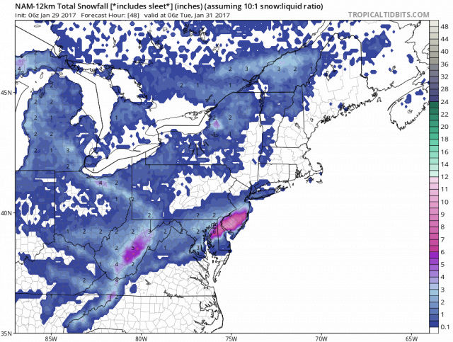
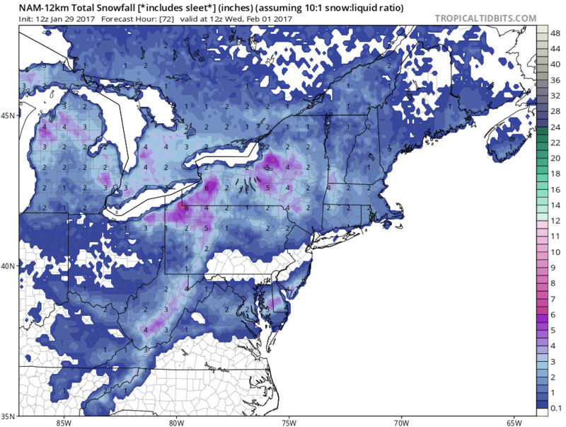
The 18z nam popping a low off The Jersey coast for Monday get some snow into the City and Long Island

algae888- Advanced Forecaster

- Posts : 5311
Reputation : 46
Join date : 2013-02-05
Age : 62
Location : mt. vernon, new york
 Re: January 2017 Observations & Discussions
The 3K Nam gives Southern New Jersey 6 to 9 inches of snow on Monday up to three inches central New Jersey Shore

algae888- Advanced Forecaster

- Posts : 5311
Reputation : 46
Join date : 2013-02-05
Age : 62
Location : mt. vernon, new york
 Re: January 2017 Observations & Discussions
Wow all the nam models give the southern third of New Jersey 3 to 6 inches of snow the high-res gives more incredible from just 12 Z and 0 0 Z last night waiting for the rgem to confirm if this has any shot

algae888- Advanced Forecaster

- Posts : 5311
Reputation : 46
Join date : 2013-02-05
Age : 62
Location : mt. vernon, new york
 Re: January 2017 Observations & Discussions
Yes...that's why IVT are tough to forecast. Let's see what other short range guidance shows later on.
_________________
_______________________________________________________________________________________________________
CLICK HERE to view NJ Strong Snowstorm Classifications
 Re: January 2017 Observations & Discussions
jmanley32 wrote:Ok it's 41 and snow flurries but the noreaster was 36 and pour rain. Go figure. Doesn't make sense.
Not everywhere. Still encased in a solid white 3 inches of sleet that isn't going anywhere courteously of that storm. I get your point though. I never went above 33 that whole storm and received 6 inches of snow and sleet and freezing rain that should have been 24 inches of snow.
I'm hoping February finally brings us something we have not had since March 2015 and that is above normal snowfall in a Month with normal or below normal temperatures. That would be a refreshing change.

CPcantmeasuresnow- Wx Statistician Guru

- Posts : 7282
Reputation : 230
Join date : 2013-01-07
Age : 103
Location : Eastern Orange County, NY
 Re: January 2017 Observations & Discussions
this ivt sounds like it could deal the goods to a lucky area. This monday? As in about 36 hrs away?CPcantmeasuresnow wrote:jmanley32 wrote:Ok it's 41 and snow flurries but the noreaster was 36 and pour rain. Go figure. Doesn't make sense.
Not everywhere. Still encased in a solid white 3 inches of sleet that isn't going anywhere courteously of that storm. I get your point though. I never went above 33 that whole storm and received 6 inches of snow and sleet and freezing rain that should have been 24 inches of snow.
I'm hoping February finally brings us something we have not had since March 2015 and that is above normal snowfall in a Month with normal or below normal temperatures. That would be a refreshing change.

jmanley32- Senior Enthusiast

- Posts : 20645
Reputation : 108
Join date : 2013-12-12
Age : 43
Location : Yonkers, NY
 Re: January 2017 Observations & Discussions
jmanley32 wrote:Ok it's 41 and snow flurries but the noreaster was 36 and pour rain. Go figure. Doesn't make sense.
This is something that always fascinated me, how I could see flurries or snow showers in the mid 40's but heavy rain at 33.Guess it's a function of how thick the warmer layer of air is close to the ground.
26.6, 83%, 29.39R, mostly cloudy ATM. Calm wind. 2 inches of sleetpack still around so at least it looks like winter up here.

docstox12- Wx Statistician Guru

- Posts : 8611
Reputation : 222
Join date : 2013-01-07
Age : 74
Location : Monroe NY
 Re: January 2017 Observations & Discussions
I hoping for some snow tonight I'm in a WWA issued by Mr Holly this morning. Anything would be nice

skinsfan1177- Senior Enthusiast

- Posts : 4485
Reputation : 35
Join date : 2013-01-07
Age : 47
Location : Point Pleasant Boro
 Re: January 2017 Observations & Discussions
The smell of snow is in the air.....hope it's not my imagination currently 33*

weatherwatchermom- Senior Enthusiast

- Posts : 3892
Reputation : 78
Join date : 2014-11-25
Location : Hazlet Township, NJ
 Re: January 2017 Observations & Discussions
weatherwatchermom wrote:The smell of snow is in the air.....hope it's not my imagination currently 33*
Hopefully we see some overnight it looks like the inverted trough is favoring South and cnj atm.

skinsfan1177- Senior Enthusiast

- Posts : 4485
Reputation : 35
Join date : 2013-01-07
Age : 47
Location : Point Pleasant Boro
 Re: January 2017 Observations & Discussions
skinsfan1177 wrote:weatherwatchermom wrote:The smell of snow is in the air.....hope it's not my imagination currently 33*
Hopefully we see some overnight it looks like the inverted trough is favoring South and cnj atm.
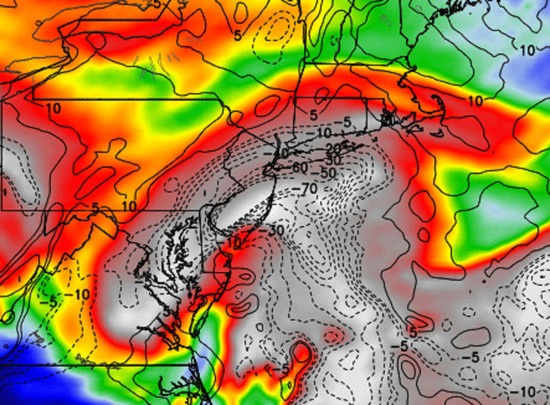
Skins you have a great chance to see unexpected snow fall from the system overnight as does all of cenral to southern NJ and LI esp the S shore. I have to get my son ready for soccer otherwise I would actually put out a snow map and a discussion. When I'm home later this afternoon I may try to put something together if someone else hasn't. Just look at vertical velocities through southern and central NJ. All we need is a trigger above and we may get some thin bands of heavy snow develop for a short period. Skins it would not surprise me if you ended up with a surprise 2-4". iTS NOT DEF OF COURSE


_________________
"In weather and in life, there's no winning and losing; there's only winning and learning."
WINTER 2012/2013 TOTALS 43.65"WINTER 2017/2018 TOTALS 62.85" WINTER 2022/2023 TOTALS 4.9"
WINTER 2013/2014 TOTALS 64.85"WINTER 2018/2019 TOTALS 14.25" WINTER 2023/2024 TOTALS 13.1"
WINTER 2014/2015 TOTALS 71.20"WINTER 2019/2020 TOTALS 6.35" WINTER 2024/2025 TOTALS 0.00
WINTER 2015/2016 TOTALS 35.00"WINTER 2020/2021 TOTALS 37.75"
WINTER 2016/2017 TOTALS 42.25"WINTER 2021/2022 TOTALS 31.65"

sroc4- Admin

- Posts : 8458
Reputation : 302
Join date : 2013-01-07
Location : Wading River, LI
 Re: January 2017 Observations & Discussions
Tx for the quick write up ....good luck with your sons gamesroc4 wrote:skinsfan1177 wrote:weatherwatchermom wrote:The smell of snow is in the air.....hope it's not my imagination currently 33*
Hopefully we see some overnight it looks like the inverted trough is favoring South and cnj atm.
Skins you have a great chance to see unexpected snow fall from the system overnight as does all of cenral to southern NJ and LI esp the S shore. I have to get my son ready for soccer otherwise I would actually put out a snow map and a discussion. When I'm home later this afternoon I may try to put something together if someone else hasn't. Just look at vertical velocities through southern and central NJ. All we need is a trigger above and we may get some thin bands of heavy snow develop for a short period. Skins it would not surprise me if you ended up with a surprise 2-4". iTS NOT DEF OF COURSE

weatherwatchermom- Senior Enthusiast

- Posts : 3892
Reputation : 78
Join date : 2014-11-25
Location : Hazlet Township, NJ
 Re: January 2017 Observations & Discussions
Nam and srefs showing an inch of liquid this looks like 20 to 1 ratio. Could be 6 plus cnj to snj. Getting excited here.


skinsfan1177- Senior Enthusiast

- Posts : 4485
Reputation : 35
Join date : 2013-01-07
Age : 47
Location : Point Pleasant Boro

skinsfan1177- Senior Enthusiast

- Posts : 4485
Reputation : 35
Join date : 2013-01-07
Age : 47
Location : Point Pleasant Boro
 Re: January 2017 Observations & Discussions
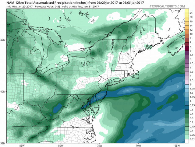
Skins I know your excited and looking for snow So am I buddy. But those maps show .20 qpf not 1 inch my man. Ant with temps at 30 tonight 20:1 is not going to happen. Hope I'm wrong though good luck
Guest- Guest
 Re: January 2017 Observations & Discussions
12z nam went south compared to prior run. Not looking good for us northern Jersey folks. 

nutleyblizzard- Senior Enthusiast

- Posts : 1963
Reputation : 41
Join date : 2014-01-30
Age : 58
Location : Nutley, new jersey
 Re: January 2017 Observations & Discussions
Who wants to chip in on a snow maker machine on a flat bed? Doc and I could drive it around to members' home and bring some snow happiness around. It would get a lot of work around and above I-84.

dkodgis- Senior Enthusiast

- Posts : 2688
Reputation : 98
Join date : 2013-12-29
 Re: January 2017 Observations & Discussions
syosnow94 wrote:Skins I know your excited and looking for snow So am I buddy. But those maps show .20 qpf not 1 inch my man. Ant with temps at 30 tonight 20:1 is not going to happen. Hope I'm wrong though good luck

skinsfan1177- Senior Enthusiast

- Posts : 4485
Reputation : 35
Join date : 2013-01-07
Age : 47
Location : Point Pleasant Boro
 Re: January 2017 Observations & Discussions
Skinns , what a beauty NAM model overnight. Unfortunately it went south and basically misses us totally.
 Re: January 2017 Observations & Discussions
Here's an update on the 3 storm threats. The SCI is updated on the homepage.
IVT: If this sets up, it will bring accumulating snow to southern and coastal NJ into Central and eastern LI. A coating to an inch is possible for the rest of NJ, including NYC Since these are largely unpredictable, I'm keeping probability low. As much as 3 to 5 inches of snow is possible if it sets up. Timing would be late tonight through 10am Monday (tomorrow).
Clipper: I downgraded chances for accumulating snow from 40 to 20%. The upper air energy is simply not digging nor strong enough to bring about a strong surface low capable of dropping a few inches of snow. We'll see how this trends today and tomorrow, but models aren't impressed. The H5 energy is literally strung out from coast to coast. If a piece was able to break off and become it's own entity we would have seen a good storm.
February 6th: this one remain out in the LR but it's clear a storm will only happen if the Pacific cooperates. A ridge out west or over the EPO domain will allow the polar energy to dig into the eastern CONUS and interact with southern stream energy to bring about a coastal low. This no longer looks like a SWFE since we're reliant on the northern energy. This no longer looks like southern stream dominant storm. The EURO flattens the PAC ridge while GFS keeps it intact to bring about a storm. Will look at this more on Tuesday.
_________________
_______________________________________________________________________________________________________
CLICK HERE to view NJ Strong Snowstorm Classifications
 Re: January 2017 Observations & Discussions
Hi Res NAM for clipper on Tuesday


_________________
_______________________________________________________________________________________________________
CLICK HERE to view NJ Strong Snowstorm Classifications
 Re: January 2017 Observations & Discussions
As a betting man our 3 snow chances look a lot closer to not happening then happening. Swing and a miss. If these 3 events were forecast to be rain storms then we'd be in!!
Guest- Guest
 Re: January 2017 Observations & Discussions
GFS tomorrow morning. Snowy.


_________________
_______________________________________________________________________________________________________
CLICK HERE to view NJ Strong Snowstorm Classifications
 Re: January 2017 Observations & Discussions
dkodgis wrote:Who wants to chip in on a snow maker machine on a flat bed? Doc and I could drive it around to members' home and bring some snow happiness around. It would get a lot of work around and above I-84.
LOL, Damian, I think you have a great idea there! Kinda like ski resorts, we could put 6 to 12 on the members property,lol.
looks like any chances of snow are way S and E of us tomorrow.

docstox12- Wx Statistician Guru

- Posts : 8611
Reputation : 222
Join date : 2013-01-07
Age : 74
Location : Monroe NY
Page 11 of 13 •  1, 2, 3 ... 10, 11, 12, 13
Page 11 of 13
Permissions in this forum:
You cannot reply to topics in this forum
 Home
Home