
 Search
Long Range Thread 16.0
Page 6 of 40 •  1 ... 5, 6, 7 ... 23 ... 40
 ![]()
Re: Long Range Thread 16.0
![]() by Frank_Wx Sat Dec 30, 2017 2:04 am
by Frank_Wx Sat Dec 30, 2017 2:04 am
Frank_Wx- Godzilla Seeker

- Posts : 21324
Join date : 2013-01-05 -

Re: Long Range Thread 16.0
![]() by jmanley32 Sat Dec 30, 2017 2:55 am
by jmanley32 Sat Dec 30, 2017 2:55 am
jmanley32- Senior Enthusiast

- Posts : 20646
Join date : 2013-12-13
Re: Long Range Thread 16.0
![]() by jmanley32 Sat Dec 30, 2017 3:33 am
by jmanley32 Sat Dec 30, 2017 3:33 am

jmanley32- Senior Enthusiast
- Posts : 20646
Reputation : 108
Join date : 2013-12-13
Age : 43
Location : Yonkers, NY
Re: Long Range Thread 16.0
![]() by nutleyblizzard Sat Dec 30, 2017 3:43 am
by nutleyblizzard Sat Dec 30, 2017 3:43 am
That was close. EPS ensembles should be interesting. Great trends tonight with all the major models. We're back in the ballgame folks. See you guys tomorrow at 12z!jmanley32 wrote:Woo euro is well west with acnonster 953mb storm. Still has ways go to catch us full blown but like you guys said we have that time. Now let's hope it continues west or at least stays the same.

nutleyblizzard- Senior Enthusiast
- Posts : 1963
Reputation : 41
Join date : 2014-01-30
Age : 58
Location : Nutley, new jersey
Re: Long Range Thread 16.0
![]() by jmanley32 Sat Dec 30, 2017 3:51 am
by jmanley32 Sat Dec 30, 2017 3:51 am
jmanley32- Senior Enthusiast
- Posts : 20646
Reputation : 108
Join date : 2013-12-13
Age : 43
Location : Yonkers, NY
Re: Long Range Thread 16.0
![]() by jmanley32 Sat Dec 30, 2017 3:59 am
by jmanley32 Sat Dec 30, 2017 3:59 am
can someone post the eps indie snow maps in the morning?nutleyblizzard wrote:That was close. EPS ensembles should be interesting. Great trends tonight with all the major models. We're back in the ballgame folks. See you guys tomorrow at 12z!jmanley32 wrote:Woo euro is well west with acnonster 953mb storm. Still has ways go to catch us full blown but like you guys said we have that time. Now let's hope it continues west or at least stays the same.
jmanley32- Senior Enthusiast
- Posts : 20646
Reputation : 108
Join date : 2013-12-13
Age : 43
Location : Yonkers, NY
Re: Long Range Thread 16.0
![]() by rb924119 Sat Dec 30, 2017 4:16 am
by rb924119 Sat Dec 30, 2017 4:16 am
rb924119- Meteorologist

- Posts : 7109
Reputation : 195
Join date : 2013-02-06
Age : 32
Location : Greentown, Pa
Re: Long Range Thread 16.0
![]() by docstox12 Sat Dec 30, 2017 8:13 am
by docstox12 Sat Dec 30, 2017 8:13 am

docstox12- Wx Statistician Guru

- Posts : 8615
Reputation : 222
Join date : 2013-01-07
Age : 74
Location : Monroe NY
Re: Long Range Thread 16.0
![]() by jmanley32 Sat Dec 30, 2017 8:37 am
by jmanley32 Sat Dec 30, 2017 8:37 am
jmanley32- Senior Enthusiast
- Posts : 20646
Reputation : 108
Join date : 2013-12-13
Age : 43
Location : Yonkers, NY
Re: Long Range Thread 16.0
![]() by Sanchize06 Sat Dec 30, 2017 8:46 am
by Sanchize06 Sat Dec 30, 2017 8:46 am
jmanley32 wrote:The west trend continues gfs is now another big jump west giving easto ren areas snow now.
Yep and 6z GEFS are even further west than that
Sanchize06- Senior Enthusiast
- Posts : 1041
Reputation : 21
Join date : 2013-02-06
Location : Union Beach, NJ

skinsfan1177- Senior Enthusiast
- Posts : 4485
Reputation : 35
Join date : 2013-01-07
Age : 47
Location : Point Pleasant Boro
Re: Long Range Thread 16.0
![]() by docstox12 Sat Dec 30, 2017 9:13 am
by docstox12 Sat Dec 30, 2017 9:13 am
skinsfan1177 wrote:Look at these shifts
Skins, GREAT depiction of the latest trend.I like it!!!!
docstox12- Wx Statistician Guru
- Posts : 8615
Reputation : 222
Join date : 2013-01-07
Age : 74
Location : Monroe NY
Re: Long Range Thread 16.0
![]() by Carter bk Sat Dec 30, 2017 9:16 am
by Carter bk Sat Dec 30, 2017 9:16 am
Carter bk- Posts : 73
Reputation : 5
Join date : 2017-12-07
Re: Long Range Thread 16.0
![]() by nutleyblizzard Sat Dec 30, 2017 9:49 am
by nutleyblizzard Sat Dec 30, 2017 9:49 am
Many of the members are now in the benchmark.Sanchize06 wrote:jmanley32 wrote:The west trend continues gfs is now another big jump west giving easto ren areas snow now.
Yep and 6z GEFS are even further west than that
nutleyblizzard- Senior Enthusiast
- Posts : 1963
Reputation : 41
Join date : 2014-01-30
Age : 58
Location : Nutley, new jersey
Re: Long Range Thread 16.0
![]() by skinsfan1177 Sat Dec 30, 2017 9:55 am
by skinsfan1177 Sat Dec 30, 2017 9:55 am
skinsfan1177- Senior Enthusiast
- Posts : 4485
Reputation : 35
Join date : 2013-01-07
Age : 47
Location : Point Pleasant Boro
Re: Long Range Thread 16.0
![]() by Quietace Sat Dec 30, 2017 9:56 am
by Quietace Sat Dec 30, 2017 9:56 am
Can you give a quantitative value rather than a qualitative description. How many members are now on BM in comparison to prior runs?nutleyblizzard wrote:Many of the members are now in the benchmark.Sanchize06 wrote:jmanley32 wrote:The west trend continues gfs is now another big jump west giving easto ren areas snow now.
Yep and 6z GEFS are even further west than that

Quietace- Meteorologist - Mod

- Posts : 3689
Reputation : 33
Join date : 2013-01-07
Age : 27
Location : Point Pleasant, NJ
skinsfan1177- Senior Enthusiast
- Posts : 4485
Reputation : 35
Join date : 2013-01-07
Age : 47
Location : Point Pleasant Boro
Re: Long Range Thread 16.0
![]() by Carter bk Sat Dec 30, 2017 10:22 am
by Carter bk Sat Dec 30, 2017 10:22 am
Carter bk- Posts : 73
Reputation : 5
Join date : 2017-12-07
Re: Long Range Thread 16.0
![]() by Frank_Wx Sat Dec 30, 2017 10:29 am
by Frank_Wx Sat Dec 30, 2017 10:29 am
_________________
_______________________________________________________________________________________________________
CLICK HERE to view NJ Strong Snowstorm Classifications

Frank_Wx- Godzilla Seeker
- Posts : 21324
Reputation : 328
Join date : 2013-01-05
Age : 32
Location : Jersey City, NJ -
Re: Long Range Thread 16.0
![]() by billg315 Sat Dec 30, 2017 10:40 am
by billg315 Sat Dec 30, 2017 10:40 am

billg315- Advanced Forecaster - Mod

- Posts : 4562
Reputation : 185
Join date : 2015-01-24
Age : 50
Location : Flemington, NJ
Re: Long Range Thread 16.0
![]() by amugs Sat Dec 30, 2017 10:44 am
by amugs Sat Dec 30, 2017 10:44 am
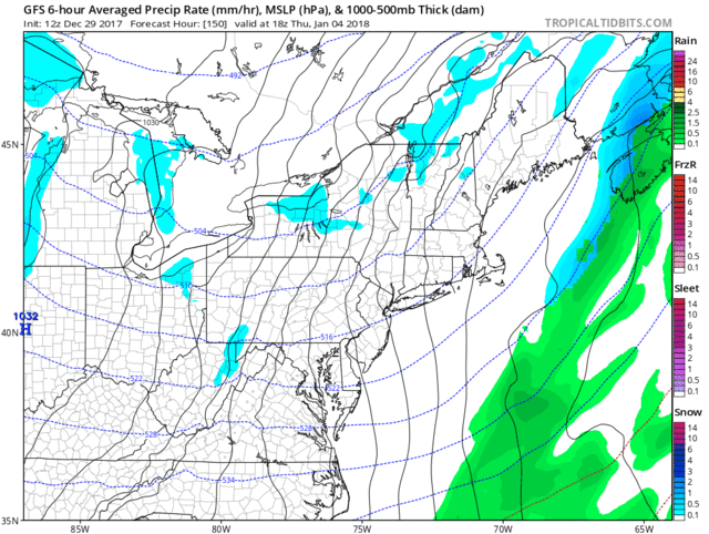
Laid out why the pattern has the POTENTIAL to produce. Still 4 days away from models having full sampling of all energy pieces but they are trending better. Wish it was 48 hours till show time.
Okay, N EPO gets a octane boost from another PAC jet extension from our frinds in the East Asia Mountain Range aka Himalayas Region and east. This as forecasted will allow the N EPO to sustain and rebuild which will thwart or hold off the thaw we shall get no help in Jan from the PV as Frank noted at this time of current projections
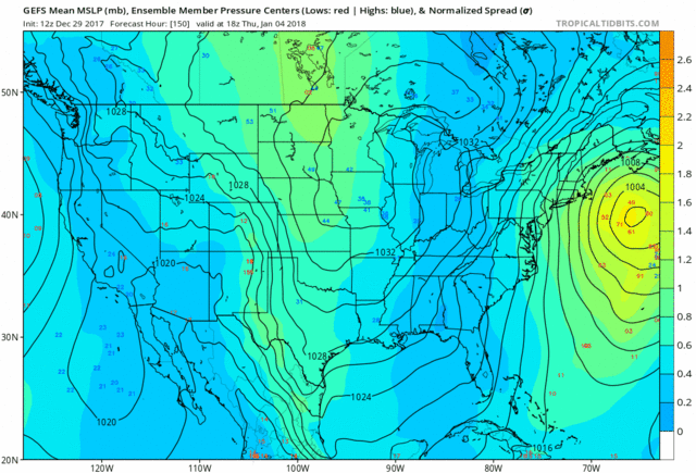
GEFS from another board that has an in depth discussion going on this


SE Ridge wants to flex it's muscle but this is going to quell it. Going to be a very tight and interesting gradient. Meaning Sroc and Syo on LI could be in the 50''s whIle I'm in the 40* range and and DOC and CP are in the mid 30's range along with EPA. Time will tell
_________________
Mugs
AKA:King: Snow Weenie
Self Proclaimed
WINTER 2014-15 : 55.12" +.02 for 6 coatings (avg. 35")
WINTER 2015-16 Total - 29.8" (Avg 35")
WINTER 2016-17 : 39.5" so far

amugs- Advanced Forecaster - Mod
- Posts : 15149
Reputation : 213
Join date : 2013-01-07
Age : 54
Location : Hillsdale,NJ
Re: Long Range Thread 16.0
![]() by Frank_Wx Sat Dec 30, 2017 10:49 am
by Frank_Wx Sat Dec 30, 2017 10:49 am
billg315 wrote:The deeper trough in the central US seems to be bringing the storm closer to the coast, so for me the question is, are there signs that the trough will dig deep there? Not really sure what to look for in that regard (I.e. is it the strength of the cold air, the strength of the wave in the Midwest, etc?)
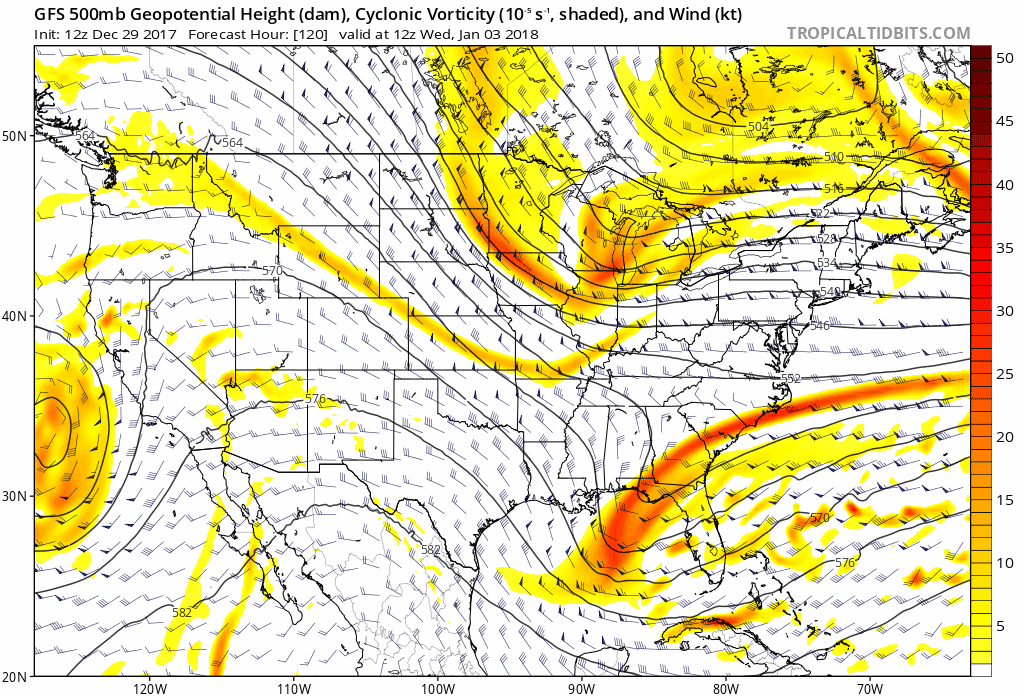
I would pay attention to the ridge and the northern stream energy. This trend GIF of the last 4 GFS images at 500mb shows how the ridge has trended stronger. As a result, it's placed further west and allows the northern stream energy to dig sooner. The northern stream energy is also trending stronger. Since the ridge is further west it allows the trough to be placed more west too. The stronger northern stream energy - which is now digging into the eastern CONUS instead of progressively tracking east - allows phasing to occur with the southern branch. In future runs we want either the northern stream energy to dig faster even more or get the southern branch to slow down.
_________________
_______________________________________________________________________________________________________
CLICK HERE to view NJ Strong Snowstorm Classifications
Frank_Wx- Godzilla Seeker
- Posts : 21324
Reputation : 328
Join date : 2013-01-05
Age : 32
Location : Jersey City, NJ -
Re: Long Range Thread 16.0
![]() by billg315 Sat Dec 30, 2017 11:01 am
by billg315 Sat Dec 30, 2017 11:01 am
billg315- Advanced Forecaster - Mod
- Posts : 4562
Reputation : 185
Join date : 2015-01-24
Age : 50
Location : Flemington, NJ
Re: Long Range Thread 16.0
![]() by amugs Sat Dec 30, 2017 11:11 am
by amugs Sat Dec 30, 2017 11:11 am
Where is our current vort maxima’s? Well our trailing shortwave (PJ) is within that North Pac gyre while our lead vort is heading towards the coast of BC, and that’ll be fully sampled by RAOB come tomorrow night. So with these great trends we’re seeing, just imagine until we get full sampling of that shortwave still way out in the pacific, SW of the Aluetians. By 0z Monday, we’ll have full sampling of both shortwaves.
Exciting times in the next 48 hours to weenie land.


Anticipation is going to be the death of the weeenies.
_________________
Mugs
AKA:King: Snow Weenie
Self Proclaimed
WINTER 2014-15 : 55.12" +.02 for 6 coatings (avg. 35")
WINTER 2015-16 Total - 29.8" (Avg 35")
WINTER 2016-17 : 39.5" so far
amugs- Advanced Forecaster - Mod
- Posts : 15149
Reputation : 213
Join date : 2013-01-07
Age : 54
Location : Hillsdale,NJ
Re: Long Range Thread 16.0
![]() by skinsfan1177 Sat Dec 30, 2017 11:22 am
by skinsfan1177 Sat Dec 30, 2017 11:22 am
billg315 wrote:The deeper trough in the central US seems to be bringing the storm closer to the coast, so for me the question is, are there signs that the trough will dig deep there? Not really sure what to look for in that regard (I.e. is it the strength of the cold air, the strength of the wave in the Midwest, etc?)
I would pay attention to the ridge and the northern stream energy. This trend GIF of the last 4 GFS images at 500mb shows how the ridge has trended stronger. As a result, it's placed further west and allows the northern stream energy to dig sooner. The northern stream energy is also trending stronger. Since the ridge is further west it allows the trough to be placed more west too. The stronger northern stream energy - which is now digging into the eastern CONUS instead of progressively tracking east - allows phasing to occur with the southern branch. In future runs we want either the northern stream energy to dig faster even more or get the southern branch to slow down.[
Some other things I like to add frank also notice that the vort crashing into the west coast doesn't look as stout. Which will help the affects downstream I also noticed the WAR LOOKS to be back which could help us out
skinsfan1177- Senior Enthusiast
- Posts : 4485
Reputation : 35
Join date : 2013-01-07
Age : 47
Location : Point Pleasant Boro
Re: Long Range Thread 16.0
![]() by amugs Sat Dec 30, 2017 11:42 am
by amugs Sat Dec 30, 2017 11:42 am
Look at the 6Z gefs
Wow some are really bad boys. Good sign. Models picking up on synoptic set up hemispherical here.

_________________
Mugs
AKA:King: Snow Weenie
Self Proclaimed
WINTER 2014-15 : 55.12" +.02 for 6 coatings (avg. 35")
WINTER 2015-16 Total - 29.8" (Avg 35")
WINTER 2016-17 : 39.5" so far
amugs- Advanced Forecaster - Mod
- Posts : 15149
Reputation : 213
Join date : 2013-01-07
Age : 54
Location : Hillsdale,NJ
Re: Long Range Thread 16.0
![]() by amugs Sat Dec 30, 2017 11:45 am
by amugs Sat Dec 30, 2017 11:45 am
_________________
Mugs
AKA:King: Snow Weenie
Self Proclaimed
WINTER 2014-15 : 55.12" +.02 for 6 coatings (avg. 35")
WINTER 2015-16 Total - 29.8" (Avg 35")
WINTER 2016-17 : 39.5" so far
amugs- Advanced Forecaster - Mod
- Posts : 15149
Reputation : 213
Join date : 2013-01-07
Age : 54
Location : Hillsdale,NJ
Page 6 of 40 • 1 ... 5, 6, 7 ... 23 ... 40 ![]()