Long Range Thread 16.0
+44
snowday111
HectorO
Grselig
essexcountypete
Snow88
mwilli5783
WeatherBob
NjWeatherGuy
Dunnzoo
jake732
aiannone
crippo84
bobjohnsonforthehall
Scullybutcher
algae888
dsix85
dkodgis
sroc4
emokid51783
Math23x7
Sanchize06
docstox12
billg315
oldtimer
CPcantmeasuresnow
skinsfan1177
Quietace
SENJsnowman
lglickman1
hyde345
MattyICE
Carter bk
RJB8525
jimv45
amugs
GreyBeard
weatherwatchermom
SoulSingMG
nutleyblizzard
mikeypizano
rb924119
frank 638
jmanley32
Frank_Wx
48 posters
Page 36 of 40
Page 36 of 40 •  1 ... 19 ... 35, 36, 37, 38, 39, 40
 Re: Long Range Thread 16.0
Dougie Fresh with his insight:
The PNA and EPO link very nicely on the 8th or so, sending a beautiful area of high pressure down into the CONUS, setting up a large temperature gradient for the 10th threat. This large, sprawling area of surface high pressure is not something we have for the 4-5th and 7-8th storms, so this is a good thing.
It will get quite cold in the CONUS for a few days as that HP sets in. But the Pacific Jet extension afterwards looks to be inevitable, leading to a more zonal pattern and warmth across the CONUS, while we reshuffle things in the Stratosphere. It's still not really a warm pattern in the East, though -- but it could have an "ugly" look for a couple of days.
amugs- Advanced Forecaster - Mod

- Posts : 15148
Join date : 2013-01-07
 Re: Long Range Thread 16.0
Our next chance of snow for everyone according to the Goldberg will be next Saturday. For our Wednesday storm. Expect all rain with temperatures in the 50 SMH
frank 638- Senior Enthusiast

- Posts : 2880
Join date : 2016-01-01
 Re: Long Range Thread 16.0
frank 638 wrote:Our next chance of snow for everyone according to the Goldberg will be next Saturday. For our Wednesday storm. Expect all rain with temperatures in the 50 SMH


Guest- Guest
frank 638- Senior Enthusiast

- Posts : 2880
Reputation : 37
Join date : 2016-01-01
Age : 41
Location : bronx ny
 Re: Long Range Thread 16.0
Note: I am not saying this will happen. I am just pointing something out from model guidance.
The 500 mb anomaly map Hr 192 of the 12Z ECMWF has heights over Greenland which are anything but ideal. This in turn would give us a super positive NAO in the +2 to +3 range.

For historical context, the highest daily NAO index on record according to the CPC was +2.751, which occurred in December 2015. I don't think I have to explain how that month turned out
The 500 mb anomaly map Hr 192 of the 12Z ECMWF has heights over Greenland which are anything but ideal. This in turn would give us a super positive NAO in the +2 to +3 range.

For historical context, the highest daily NAO index on record according to the CPC was +2.751, which occurred in December 2015. I don't think I have to explain how that month turned out
Math23x7- Wx Statistician Guru

- Posts : 2382
Reputation : 68
Join date : 2013-01-08
 Re: Long Range Thread 16.0
Math23x7 wrote:Note: I am not saying this will happen. I am just pointing something out from model guidance.
The 500 mb anomaly map Hr 192 of the 12Z ECMWF has heights over Greenland which are anything but ideal. This in turn would give us a super positive NAO in the +2 to +3 range.
For historical context, the highest daily NAO index on record according to the CPC was +2.751, which occurred in December 2015. I don't think I have to explain how that month turned out
That was also during the peak of one of the strongest El Ninos ever. It's not the case right now so hopefully not the same result. I was hoping to never see a repeat of a December 2015 in my lifetime but if this happens it's your fault. I hope you can live with yourself.

CPcantmeasuresnow- Wx Statistician Guru

- Posts : 7282
Reputation : 230
Join date : 2013-01-07
Age : 103
Location : Eastern Orange County, NY
 Re: Long Range Thread 16.0
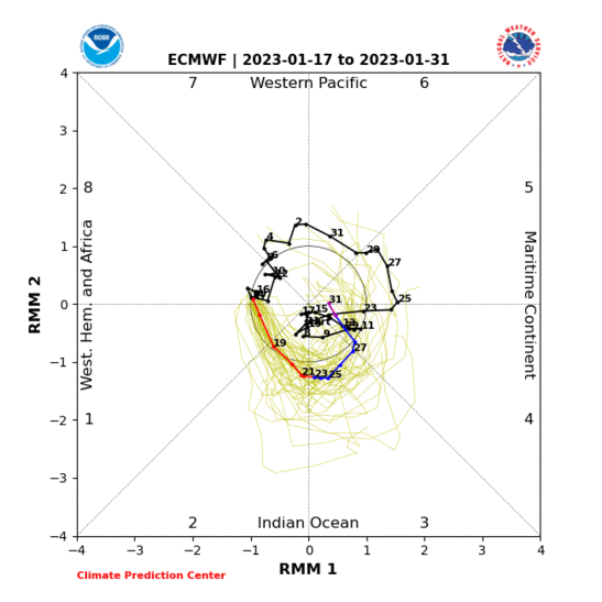
And why the absolute worst case scenery instead of the beat case from plots shown the MJO traversing g through phase 7 to 8?? Speaks volumes of where you stand and your appeal. How about a snowmap from the GFS or CMC in the LR or your friend the EPS?
This is hope, saves winter.

This is hope, saves winter.

_________________
Mugs
AKA:King: Snow Weenie
Self Proclaimed
WINTER 2014-15 : 55.12" +.02 for 6 coatings (avg. 35")
WINTER 2015-16 Total - 29.8" (Avg 35")
WINTER 2016-17 : 39.5" so far

amugs- Advanced Forecaster - Mod

- Posts : 15148
Reputation : 213
Join date : 2013-01-07
Age : 54
Location : Hillsdale,NJ
 Re: Long Range Thread 16.0

Joe Bastardi

@BigJoeBastardi
West Wind burst serves 2 purposes 1) its a cattle prod to the atmosphere as powerful MJO part due to low solar and east qbo continues moving toward colder phases. Same thing happened in December to set could up
2) Likely beginning of end of La Nina. Weak Modoki nino next winter
8:03 AM - Feb 3, 2018
Also, we have seen this before with the SOI were it tanks and sends the MJO into more favorable phases like 8 through 2.
Time will tell here.
Could we have a wild 2-3/4 week period from spanning latter Feb through mid March with these factors?
_________________
Mugs
AKA:King: Snow Weenie
Self Proclaimed
WINTER 2014-15 : 55.12" +.02 for 6 coatings (avg. 35")
WINTER 2015-16 Total - 29.8" (Avg 35")
WINTER 2016-17 : 39.5" so far

amugs- Advanced Forecaster - Mod

- Posts : 15148
Reputation : 213
Join date : 2013-01-07
Age : 54
Location : Hillsdale,NJ
 Re: Long Range Thread 16.0
JOE DA LEO
"
When I trust the GEFS more
It is not because it its in line with our ideas for the winter or am wishcasting. There is good reason for not believing what the GEM andEPS are saying about the cold vanishing mid-month.
Major changes are taking place high up in the atmosphere with the east QBO and low solar activity and the vanishing of geomagnetic storms all of which favor high latitude blocking developing.
Check this incredible warming at 30mb and 10mb on the latest runs.
.jpg)
.jpg)
That should propagate down to the mid troposphere and tank the AO and eventually NAO
"
When I trust the GEFS more
It is not because it its in line with our ideas for the winter or am wishcasting. There is good reason for not believing what the GEM andEPS are saying about the cold vanishing mid-month.
Major changes are taking place high up in the atmosphere with the east QBO and low solar activity and the vanishing of geomagnetic storms all of which favor high latitude blocking developing.
Check this incredible warming at 30mb and 10mb on the latest runs.
.jpg)
.jpg)
That should propagate down to the mid troposphere and tank the AO and eventually NAO
_________________
Mugs
AKA:King: Snow Weenie
Self Proclaimed
WINTER 2014-15 : 55.12" +.02 for 6 coatings (avg. 35")
WINTER 2015-16 Total - 29.8" (Avg 35")
WINTER 2016-17 : 39.5" so far

amugs- Advanced Forecaster - Mod

- Posts : 15148
Reputation : 213
Join date : 2013-01-07
Age : 54
Location : Hillsdale,NJ
 Re: Long Range Thread 16.0
We have 2 chances coming this Tuesday night to Wednesday morning exp for the northern parts then next Weekend. Never thought this Sunday would mount to anything.
jimv45- Senior Enthusiast

- Posts : 1168
Reputation : 36
Join date : 2013-09-20
Location : Hopewell jct.

aiannone- Senior Enthusiast - Mod

- Posts : 4827
Reputation : 92
Join date : 2013-01-07
Location : Saint James, LI (Northwest Suffolk Co.)
 Re: Long Range Thread 16.0
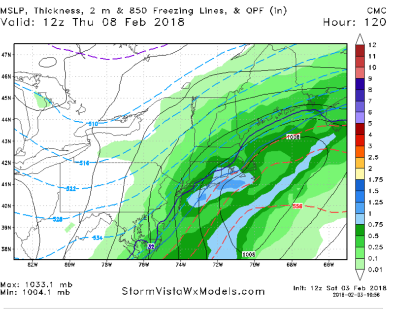
Both the GFS and CMC trended colder for the midweek storm just get the precipitation here and I'll take my chances will be riding on the edge on a lot of these but I'm sure one of them is going to turn out more favorable for usaiannone wrote:12z CMC for midweek:

algae888- Advanced Forecaster

- Posts : 5311
Reputation : 46
Join date : 2013-02-05
Age : 62
Location : mt. vernon, new york
 Re: Long Range Thread 16.0
Absolutely great article by Earth light in the upcoming Sudden Stratospheric Warming (SSW) event that looks to take place Feb 20th. What dies this mean? Well we could have a wild 3 week period from the 20th to mid March with the most elusive Negative NAO. This time of year we have BIGGLY storms and with the monster westerly wind burst forcing the MJO wave to come east into pahse 8 then 1 and 2 this will aid in the trough over the East coast.
Peeps, this could be a wild 3 weeks stretch that ands us AN for snowfall. I am not saying it will but the "coupling" between the SSW event and the AO tanking and NAO it could be a great stretch to end winter.
Many though we would see this early in Feb but it did not materialize. The very strong MJO phase 6 and 7 have sent all this latent heat pole ward and we see this in the latest heat Flux graphs/charts for the stratosphere.
https://www.nymetroweather.com/2018/02/03/sudden-stratospheric-warming-increasingly-likely-mean/
_________________
Mugs
AKA:King: Snow Weenie
Self Proclaimed
WINTER 2014-15 : 55.12" +.02 for 6 coatings (avg. 35")
WINTER 2015-16 Total - 29.8" (Avg 35")
WINTER 2016-17 : 39.5" so far

amugs- Advanced Forecaster - Mod

- Posts : 15148
Reputation : 213
Join date : 2013-01-07
Age : 54
Location : Hillsdale,NJ
 Re: Long Range Thread 16.0
AAM chart showing the slowing down of the winds aloft which help the pattern slow down like "Igantowski" from one of the greatest episodes on TV
Earth light.posted this showing the change again this is all due to the WWB

Earth light.posted this showing the change again this is all due to the WWB

Last edited by amugs on Sat Feb 03, 2018 5:39 pm; edited 1 time in total
_________________
Mugs
AKA:King: Snow Weenie
Self Proclaimed
WINTER 2014-15 : 55.12" +.02 for 6 coatings (avg. 35")
WINTER 2015-16 Total - 29.8" (Avg 35")
WINTER 2016-17 : 39.5" so far

amugs- Advanced Forecaster - Mod

- Posts : 15148
Reputation : 213
Join date : 2013-01-07
Age : 54
Location : Hillsdale,NJ
 Re: Long Range Thread 16.0
We can all post all the charts we want, but until the PV moves further southeast by a couple of hundred miles minimum, we will continue to have all the spokes of energy (short waves) having too much time to round the bend therefore ending up tracking over or west of us. No good
Guest- Guest
 Re: Long Range Thread 16.0
syosnow94 wrote:We can all post all the charts we want, but until the PV moves further southeast by a couple of hundred miles minimum, we will continue to have all the spokes of energy (short waves) having too much time to round the bend therefore ending up tracking over or west of us. No good
Yes and no. This is the PV position now without a split. We get to the time frame outlined we split the PV and in tandem with a N NAO forming from this. Low AAM along with a WWB in parallel with the MJO going into phase 8 then looks to charge east into and possible 2 has confidence for a good tompossibly great patttern. Many of the pro met are on board with this and if they crash and burn so be it. But the PV position now again is not what I am referring to for this time frame. I'll send you a pair of my weenie shades to help if you'd like. This coming from the man who has 30"of white gold on the year.
There are a lot of positives for this time frame be patient as curgently modeled.
_________________
Mugs
AKA:King: Snow Weenie
Self Proclaimed
WINTER 2014-15 : 55.12" +.02 for 6 coatings (avg. 35")
WINTER 2015-16 Total - 29.8" (Avg 35")
WINTER 2016-17 : 39.5" so far

amugs- Advanced Forecaster - Mod

- Posts : 15148
Reputation : 213
Join date : 2013-01-07
Age : 54
Location : Hillsdale,NJ
 Re: Long Range Thread 16.0
Here is your WWB chart, see the reds and oranges at the bottom of the map that is phase 7 heading into 8, very good sign off the OLR site.


_________________
Mugs
AKA:King: Snow Weenie
Self Proclaimed
WINTER 2014-15 : 55.12" +.02 for 6 coatings (avg. 35")
WINTER 2015-16 Total - 29.8" (Avg 35")
WINTER 2016-17 : 39.5" so far

amugs- Advanced Forecaster - Mod

- Posts : 15148
Reputation : 213
Join date : 2013-01-07
Age : 54
Location : Hillsdale,NJ
 Re: Long Range Thread 16.0
Hopefully you are right Al. A lot of pro Mets were very bullish about the early Feb period too. That’s gone by the wayside
Guest- Guest
 Re: Long Range Thread 16.0
syosnow94 wrote:Hopefully you are right Al. A lot of pro Mets were very bullish about the early Feb period too. That’s gone by the wayside
Jim,
I agree and I hope so too. The various factors are starting to align. We'll know more in the upcoming week.
_________________
Mugs
AKA:King: Snow Weenie
Self Proclaimed
WINTER 2014-15 : 55.12" +.02 for 6 coatings (avg. 35")
WINTER 2015-16 Total - 29.8" (Avg 35")
WINTER 2016-17 : 39.5" so far

amugs- Advanced Forecaster - Mod

- Posts : 15148
Reputation : 213
Join date : 2013-01-07
Age : 54
Location : Hillsdale,NJ
 Re: Long Range Thread 16.0
As long as I can fly out March 4th for spring training! As much as I want everything to align for an awesome storm, it better not be while I'm away! Let's shoot for another President's Day storm instead!
_________________
Janet
Snowfall winter of 2023-2024 17.5"
Snowfall winter of 2022-2023 6.0"
Snowfall winter of 2021-2022 17.6" 1" sleet 2/25/22
Snowfall winter of 2020-2021 51.1"
Snowfall winter of 2019-2020 8.5"
Snowfall winter of 2018-2019 25.1"
Snowfall winter of 2017-2018 51.9"
Snowfall winter of 2016-2017 45.6"
Snowfall winter of 2015-2016 29.5"
Snowfall winter of 2014-2015 50.55"
Snowfall winter of 2013-2014 66.5"

Dunnzoo- Senior Enthusiast - Mod

- Posts : 4934
Reputation : 68
Join date : 2013-01-11
Age : 62
Location : Westwood, NJ
 Re: Long Range Thread 16.0
From tweeter look a this unbelievable spike in Heat Flux for the stratosphere. Partly due to the E QBO


_________________
Mugs
AKA:King: Snow Weenie
Self Proclaimed
WINTER 2014-15 : 55.12" +.02 for 6 coatings (avg. 35")
WINTER 2015-16 Total - 29.8" (Avg 35")
WINTER 2016-17 : 39.5" so far

amugs- Advanced Forecaster - Mod

- Posts : 15148
Reputation : 213
Join date : 2013-01-07
Age : 54
Location : Hillsdale,NJ
 Re: Long Range Thread 16.0
Models still trending colder for the Thursday storm. Looks like a snow to rain back to snow scenario for the coast and most folks NW stay all snow. Here is the 12z GFS:


_________________
-Alex Iannone-

aiannone- Senior Enthusiast - Mod

- Posts : 4827
Reputation : 92
Join date : 2013-01-07
Location : Saint James, LI (Northwest Suffolk Co.)
 Re: Long Range Thread 16.0
Getting really Trend colder with the GFS warm and the ggem the coldest model as of now however the difference for Wednesday storm compared to today's is that we have a 1040 high pressure system sitting over Maine which has trended stronger on almost all models the last 24 hours or so too bad we didn't have a negative Nao right now which would have kept the cold air locked in still looks like a solid thump of snow on the front end followed by rain and as you said back to snow for the coastal sectionsaiannone wrote:Models still trending colder for the Thursday storm. Looks like a snow to rain back to snow scenario for the coast and most folks NW stay all snow. Here is the 12z GFS:

algae888- Advanced Forecaster

- Posts : 5311
Reputation : 46
Join date : 2013-02-05
Age : 62
Location : mt. vernon, new york
 Re: Long Range Thread 16.0
rb. Early February was forecasted by most to be below normal temps and snow chances every few days. Scott’s post says we will be normal to above normal temps through the middle of February. That leaves about 4 weeks for most of the board excluding the N and W crew (who deserve more snow, except for CP. but my flame thrower will be waiting for him anyway) until spring. With the way the forecast has changed 180 degrees for early February (see Frank removing the scroll about many significant snow chances) I for one am incredibly skeptical that we don’t see things continue to trend negatively.
I’ll remain hopeful but pessimistic
I’ll remain hopeful but pessimistic
Guest- Guest
 Re: Long Range Thread 16.0
euro trended much weaker and colder for wens. looks like 2-6" for the city n and west.

algae888- Advanced Forecaster

- Posts : 5311
Reputation : 46
Join date : 2013-02-05
Age : 62
Location : mt. vernon, new york
 Re: Long Range Thread 16.0
syosnow94 wrote:rb. Early February was forecasted by most to be below normal temps and snow chances every few days. Scott’s post says we will be normal to above normal temps through the middle of February. That leaves about 4 weeks for most of the board excluding the N and W crew (who deserve more snow, except for CP. but my flame thrower will be waiting for him anyway) until spring. With the way the forecast has changed 180 degrees for early February (see Frank removing the scroll about many significant snow chances) I for one am incredibly skeptical that we don’t see things continue to trend negatively.
I’ll remain hopeful but pessimistic
To your first point:
1. We have had two CHANCES snow and it's only February 4th. Unfortunately, the coastal plain has wound up on the warm side of them with the NW winning out.
2. If you look at the averages so far for the month, I believe you will see that the region is generally near to slightly below normal. With it being only four days in, and the expected upcoming pattern, I think a below-normal February with respect to temperatures is VERY LIKELY, with the largest departures from the mean in the second half of the month. As for snow chances in the future, here comes another one on a Wednesday and then next weekend again, with similar frequency progged thereafter given the projected pattern.
3. Based on the two above points, the outlooks have mainly verified so far, even if not in your backyard, and look very likely to continue to verify.
4. Some mets, including myself, Armando, and Frank (if I recall correctly), were not, nor have ever been, on board with the idea that the true pattern change would occur by this point. We always favored at least until the 7th-10th ofnthe month before it locked in and were adamant that the opening week or so would be a transitional step-down BACK into the winter pattern.
To your second point, quoted directly from Scott's discussion:
"For now we will have to settle for a "mediocre" pattern. There will be several chances at snow, and temps will likely avg N to BN overall I believe for the first 15-20days of Feb. But the snow chances def favor interior sections as the pattern is such that its more likely that we see storm tracks that warm sector the area out ahead of the storm with possible front end snows followed by mixing and or rain along the coastal plain; then return to cold BN temps after it all passes. This of course doesn't mean that we cant get a decent system come together for the coast as well if the Pac and Polar s/w's are timed just right."
To your third point, the above means you should go back and check your math, because like your snow totals, it seems to be off :p
And to your fourth and final point, the forecast has not changed at all, at least from my perspective, but maybe from the others you have followed which I am unaware of, they have. I cannot comment on said other forecasts.
rb924119- Meteorologist

- Posts : 7103
Reputation : 195
Join date : 2013-02-06
Age : 32
Location : Greentown, Pa
 Re: Long Range Thread 16.0
for the wens and next weekend system what the models are starting to show is better HP placement which should allow for more confluence to our north and hence a colder solution. something to keep monitoring over the next few days.

algae888- Advanced Forecaster

- Posts : 5311
Reputation : 46
Join date : 2013-02-05
Age : 62
Location : mt. vernon, new york
Page 36 of 40 •  1 ... 19 ... 35, 36, 37, 38, 39, 40
Page 36 of 40
Permissions in this forum:
You cannot reply to topics in this forum
 Home
Home